OmahaSnowFan
-
Posts
2693 -
Joined
-
Last visited
-
Days Won
1
Everything posted by OmahaSnowFan
-
12/10 to 12/11 Upper Midwest Snow Storm
OmahaSnowFan replied to bud2380's topic in East of the Rockies
based on the Euro, it shows early to mid afternoon -
December 2021 Observations and Discussion
OmahaSnowFan replied to Tom's topic in East of the Rockies
Even after yesterday's coldest winter day so far this season (8 degrees below average for the day), we're still at 10.0 degrees above average for the first 6 days of the month. Back to at or above normal for probably at least the next 10 days. GFS keeps showing us near 70 next Wednesday, 12/15 too. -
December 2021 Observations and Discussion
OmahaSnowFan replied to Tom's topic in East of the Rockies
Coldest day here since February 19th! Only 30.2 degrees for the high so far and a cold wind that has finally slowed down. I still haven't had any precip since 11/13, so if this weekends storm misses us to the north, it will be a full month since any precip, rain or snow. -
12/10 to 12/11 Upper Midwest Snow Storm
OmahaSnowFan replied to bud2380's topic in East of the Rockies
Yep same here. Looking back at my records, I did have a lt mix of snow/rain on April 19th, but no accumulation and I did have some flakes fall last month on the 12th, but no measurable snow since 2/21. Wonder what our record is..... -
December 2021 Observations and Discussion
OmahaSnowFan replied to Tom's topic in East of the Rockies

-
December 2021 Observations and Discussion
OmahaSnowFan replied to Tom's topic in East of the Rockies
540 line all the way to Hudson Bay in mid December.

-
December 2021 Observations and Discussion
OmahaSnowFan replied to Tom's topic in East of the Rockies
No snow on the ground will just make it easier when it goes back to ridging and highs in the 50s after this coming week -
December 2021 Observations and Discussion
OmahaSnowFan replied to Tom's topic in East of the Rockies
Holy ridge after the storm next weekend -
December 2021 Observations and Discussion
OmahaSnowFan replied to Tom's topic in East of the Rockies
Omaha afternoon discussion
-
December 2021 Observations and Discussion
OmahaSnowFan replied to Tom's topic in East of the Rockies
Exactly. -
December 2021 Observations and Discussion
OmahaSnowFan replied to Tom's topic in East of the Rockies
It sounds like you're mad you're not in the winter storm watch.... You've actually liked quite a few of my "negative and snarky" posts lately. Weird.... I actually thought I was being funny pointing out the blizzard warnings in Hawaii. And I don't get how when others here were the ones that called the CPC "political hacks", when I use that phrase it's offensive. Anything else moderator? -
December 2021 Observations and Discussion
OmahaSnowFan replied to Tom's topic in East of the Rockies
The political hacks at the CPC don't see winter coming quite yet... 6-10 Day Outlooks 8-14 Day Outlooks Week 3-4 Outlooks -
December 2021 Observations and Discussion
OmahaSnowFan replied to Tom's topic in East of the Rockies
If you want to find winter, just go to Hawaii. https://forecast.weather.gov/wwamap/wwatxtget.php?cwa=hfo&wwa=blizzard warning URGENT - WINTER WEATHER MESSAGE National Weather Service Honolulu HI 311 AM HST Fri Dec 3 2021 ...BLIZZARD WARNING FOR THE BIG ISLAND SUMMITS... HIZ028-040215- /O.CON.PHFO.BZ.W.0001.211204T0400Z-211205T1600Z/ Big Island Summits- 311 AM HST Fri Dec 3 2021 ...BLIZZARD WARNING REMAINS IN EFFECT FROM 6 PM THIS EVENING TO 6 AM HST SUNDAY... * WHAT...Blizzard conditions expected. Total snow accumulations of up to 12 inches or more. Winds gusting over 100 mph. * WHERE...Big Island Summits. * WHEN...From 6 PM this evening to 6 AM HST Sunday. * IMPACTS...Travel could be very difficult to impossible. Blowing snow will significantly reduce visibility at times, with periods of zero visibility. See the High Wind Warning that is also in effect. * ADDITIONAL DETAILS...The strong winds will likely cause significant drifting of snow. -
December 2021 Observations and Discussion
OmahaSnowFan replied to Tom's topic in East of the Rockies
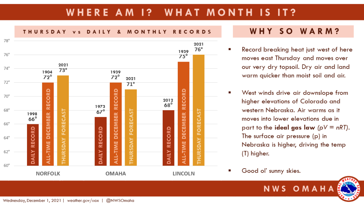
Failed to hit the elusive 70 in December. Still hit 68.0 IMBY and at the airport which broke the daily record. I believe that’s the 4th record high in just the last 5 weeks and 5th since the end of September. -
December 2021 Observations and Discussion
OmahaSnowFan replied to Tom's topic in East of the Rockies
Don't think we're going to break any records today and 70 might be out of reach as well. Only up to 64.8 as of 1p and our afternoon highs have been occurring around 215 each day this past week. -
December 2021 Observations and Discussion
OmahaSnowFan replied to Tom's topic in East of the Rockies
Up to 61.0 IMBY, up from 54.5 an hour ago. One would think 70 should be an easy target with 3-3.5 hours of heating yet.... Valley NWS isn't so sure. Just sent out this update. UPDATE... Issued at 1040 AM CST Thu Dec 2 2021 We did lower the high temperature forecast a couple of degrees this morning. Have some concern about overall poor mixing and whether the true warmth can be realized. Will monitor how temps rise in the next few hours. Still a fabulous day, but just a couple degrees lower than previously forecast. -
December 2021 Observations and Discussion
OmahaSnowFan replied to Tom's topic in East of the Rockies
That’s a lot of brown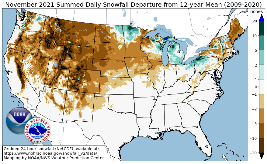
-
December 2021 Observations and Discussion
OmahaSnowFan replied to Tom's topic in East of the Rockies
All time record set for consecutive days over 80 in Phoenix in November https://amp.azcentral.com/amp/8823241002 -
December 2021 Observations and Discussion
OmahaSnowFan replied to Tom's topic in East of the Rockies
Looking back at my data, I show we were in the upper 80s to lower 90s the 26th-28th of September with a record high of 93 on the 27th and a non record high of 94 on the 28th -
December 2021 Observations and Discussion
OmahaSnowFan replied to Tom's topic in East of the Rockies
I’m getting a little worried about tomorrow’s highs. All of the short range hi res models keep highs well down into the 60s and even some upper 50s across eastern Nebraska tomorrow. -
December 2021 Observations and Discussion
OmahaSnowFan replied to Tom's topic in East of the Rockies
Are you talking about Omaha/eastern Nebraska or western SoDak and Wyoming like the post refers to? -
December 2021 Observations and Discussion
OmahaSnowFan replied to Tom's topic in East of the Rockies
All time warmth in Wyoming today.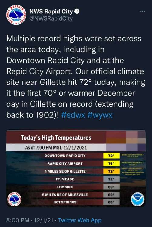
-
December 2021 Observations and Discussion
OmahaSnowFan replied to Tom's topic in East of the Rockies
-
November 2021 Observations and Discussion
OmahaSnowFan replied to Tom's topic in East of the Rockies
Here's my November stats from MBY. Avg low: 33.0 (+2.8) Lowest min: 21.0 (25th) Avg high: 55.0 (+4.7) Warmest high: 73.0 (16th) +3.8 degrees for the month (8 out of 11 months above average so far this year) .33" rain (-1.12" deficit) Trace snowfall. Set 3 record highs at the airport. I noticed last November was basically the same here as well with 32.3/55.2 for the average low and high and we only received .2" of snowfall. Then December came and the last 3 weeks of the month delivered 10" of snow, but we still ended up 4.5 degrees above normal for Dec '20. That's the way I like it, snowy and not bitterly cold, so I wouldn't mind a repeat of that this month. -
December 2021 Observations and Discussion
OmahaSnowFan replied to Tom's topic in East of the Rockies
Looks like we're going to underperform by a couple of degrees today with a high of 65 vs predicted 67. I see they've lowered the high for tomorrow by 2 degrees here as well, down to 70 from 72. All time record December high is 72, and we've only hit 70 in December 3x since records began so kinda big deal tomorrow.