bainbridgekid
-
Posts
6890 -
Joined
-
Last visited
-
Days Won
24
Everything posted by bainbridgekid
-

February 2024 Weather in the PNW
bainbridgekid replied to TigerWoodsLibido's topic in West of the Rockies
It only cut it in half from the ridiculously wet 12z. Other model runs of the NAM have been much more in line with the 18z. Half inch of QPF for Seattle is still a lot. -
February 2024 Weather in the PNW
bainbridgekid replied to TigerWoodsLibido's topic in West of the Rockies
Drier air working its way closer from both the East and North. Current DP's: Bellingham: 17 North Bend: 17 Monroe: 23 -
February 2024 Weather in the PNW
bainbridgekid replied to TigerWoodsLibido's topic in West of the Rockies
Winter Weather Advisory issued for Olympia, Chehalis, and Hood Canal. URGENT - WINTER WEATHER MESSAGE National Weather Service Seattle WA 347 AM PST Wed Feb 14 2024 WAZ504-511-512-142100- /O.NEW.KSEW.WW.Y.0006.240215T0600Z-240215T1800Z/ Southwest Interior-Hood Canal Area-Lower Chehalis Valley Area- including Lacey, Olympia, Tumwater, Yelm, Grand Mound, Rochester, Centralia, Toledo, Shelton, Seabeck, Belfair, Brinnon, Montesano, Elma, and McCleary 347 AM PST Wed Feb 14 2024 ...WINTER WEATHER ADVISORY IN EFFECT FROM 10 PM THIS EVENING TO 10 AM PST THURSDAY... * WHAT...Wet snow expected. Total snow accumulations of up to two inches. * WHERE...Lowlands of Thurston, western Lewis, and far southeast Mason Counties, including Harstine Island, Olympia, Centralia, and Toledo, Western Kitsap and the lowlands of eastern Jefferson and Mason Counties, including Brinnon, Seabeck, and Shelton and Far southwest Mason County and the interior lowlands of Grays Harbor County, including Matlock, McCleary, and Montesano. * WHEN...From 10 PM this evening to 10 AM PST Thursday. * IMPACTS...Plan on slippery road conditions.
-
February 2024 Weather in the PNW
bainbridgekid replied to TigerWoodsLibido's topic in West of the Rockies
IDK your exact location, but Mason County is one of the best spots for snow with tonight's storm. Focus on that not a fantasy storm 15 days out. -
February 2024 Weather in the PNW
bainbridgekid replied to TigerWoodsLibido's topic in West of the Rockies
12z WRF back to being snowy for Seattle (and especially the South Sound) after the fluky dry 00z last night. No dice for Portland.
-
February 2024 Weather in the PNW
bainbridgekid replied to TigerWoodsLibido's topic in West of the Rockies
12z increased snow amounts for both Seattle and Portland..thumb.png.4d625805237d18bafcbe95ecc996e649.png)
-
February 2024 Weather in the PNW
bainbridgekid replied to TigerWoodsLibido's topic in West of the Rockies
12z NAM was the snowiest run yet for Seattle. Kuchera map..thumb.png.362231006235fadec7979603862980d3.png)
- 8823 replies
-
- 12
-

-

-

-

-
February 2024 Weather in the PNW
bainbridgekid replied to TigerWoodsLibido's topic in West of the Rockies
Portland NWS feels like a fever dream sometimes. URGENT - WINTER WEATHER MESSAGE National Weather Service Portland OR 507 AM PST Wed Feb 14 2024 ORZ005-006-WAZ022-039-150030- /O.NEW.KPQR.WW.Y.0012.240215T0400Z-240216T0000Z/ Lower Columbia-Greater Portland Metro Area-I- 5 Corridor in Cowlitz County-Greater Vancouver Area- Including the cities of St. Helens, Clatskanie, Hillsboro, Portland, Wilsonville, Oregon City, Gresham, Troutdale, Longview, Kelso, Castle Rock, Vancouver, Battle Ground, Ridgefield, Washougal, Yacolt, and Amboy 507 AM PST Wed Feb 14 2024 ...WINTER WEATHER ADVISORY IN EFFECT FROM 8 PM THIS EVENING TO 4 PM PST THURSDAY... * WHAT...Wet snow expected. Total snow accumulations of up to 3 inches. Winds gusting as high as 40 mph. * WHERE...In Oregon, Lower Columbia and Greater Portland Metro Area. In Washington, I-5 Corridor in Cowlitz County and Greater Vancouver Area. * WHEN...From 8 PM this evening to 4 PM PST Thursday. * IMPACTS...Plan on slippery road conditions. The hazardous conditions could impact Thursday morning`s commute. * ADDITIONAL DETAILS...While the primary impacts are expected to occur later tonight into Thursday, there is roughly a 20 percent chance accumulating snow will impact this evening`s commute. If and when precipitation does change to snow, it can likely be assumed that precipitation will remain snow until tapering off to drizzle or light rain Thursday. Most likely areas to be impacted are north and east of Interstate 205, as well as elevations above 500 feet and the eastern slopes of the Coast Range in western Washington County. -
February 2024 Weather in the PNW
bainbridgekid replied to TigerWoodsLibido's topic in West of the Rockies
Neurotypical is a common way to describe people without ADHD, Autism, etc. -
February 2024 Weather in the PNW
bainbridgekid replied to TigerWoodsLibido's topic in West of the Rockies
This thing sure did trend South the last six runs or so..thumb.gif.1e994e268519f3368224b8d1d4910ebf.gif)
-
February 2024 Weather in the PNW
bainbridgekid replied to TigerWoodsLibido's topic in West of the Rockies
DP down to 19 in Bellingham. Tomorrow night really hinges on how well that cool dry air can push South ahead of the precip moving North. -
February 2024 Weather in the PNW
bainbridgekid replied to TigerWoodsLibido's topic in West of the Rockies
00z Euro looks significantly moister for the Central Sound. 0.5" of QPF for Seattle v. 0.2" on the 18z. Lots of 35 degree slop coming IMO. -
February 2024 Weather in the PNW
bainbridgekid replied to TigerWoodsLibido's topic in West of the Rockies
We think of the 49th parallel as being the CA/US border, but 70% of Canadians actually live South of that line. Pretty amazing. -
February 2024 Weather in the PNW
bainbridgekid replied to TigerWoodsLibido's topic in West of the Rockies
It's amazing how empty most of Canada is. It's the 4th least populated large region on Earth behind Antarctica, the Saraha and Greenland. And not only do 90% of Canadians live within 100 miles of the US, but 50% of Canadians live South of Portland, Oregon in that tiny little triangle that dips South between NY and Michigan below the red line.
-
February 2024 Weather in the PNW
bainbridgekid replied to TigerWoodsLibido's topic in West of the Rockies
And in true WRF fashion, as soon as the GFS it's supposed to be based on gets snowier, it gets way drier. Makes zero sense why it would suddenly flip totally dry even for Kitsap like that.
-
February 2024 Weather in the PNW
bainbridgekid replied to TigerWoodsLibido's topic in West of the Rockies
00z GFS also upped totals. Kuchera..thumb.png.24d52763a7953fc04a0faec072c98ed9.png)
-
February 2024 Weather in the PNW
bainbridgekid replied to TigerWoodsLibido's topic in West of the Rockies
00z NAM continues to be nutty snowy for Central and South Sound. Kuchera map..thumb.png.3d184c3dffc9dcfdf8940a906e1fd248.png)
-
February 2024 Weather in the PNW
bainbridgekid replied to TigerWoodsLibido's topic in West of the Rockies
I honestly think so few people live out there they just largely ignore it and focus their time on where 90% of people live. It's lame but there's no other good explanation for why they so often ignore Hood Canal only events till after the snow is piling up there -
February 2024 Weather in the PNW
bainbridgekid replied to TigerWoodsLibido's topic in West of the Rockies

-
February 2024 Weather in the PNW
bainbridgekid replied to TigerWoodsLibido's topic in West of the Rockies
Portland NWS never has been gun shy to talk about extreme potentials. This from their AFD. Then there is the potential worst case scenario for Wed-Thu, where the advance of the cold air is actually stronger than presently forecast. This is a main feature of the EC/GEFS ensemble members that show accumulating snow in the PDX metro lowlands. Some of the members (about 5%) still feature extreme snow accumulations of 6 to 12 inches for the metro area by late Thursday night. To provide some perspective, there are indeed some similarities between this event and the unexpected Jan 2017 snow event where much of the PDX metro saw nearly a foot of snow. That event was heavily precip intensity driven, with the thermal profile going isothermal near 0 deg C in the low levels due to heavy precip and the latent heat processes of melting and evaporation cooling the environment. That could happen with this event, but the odds are low just as they were in that case. In that event, there was probably about a 10% chance of all the ingredients to come together for a snowstorm, and they did. Would probably give similar probabilities of our Wed-Thu event having everything come together just right for heavy metro lowland snow. -
February 2024 Weather in the PNW
bainbridgekid replied to TigerWoodsLibido's topic in West of the Rockies
Drier air certainly getting to Bellingham. 32 mph NE winds and DP down to 24. Course the temp is also 50. -
February 2024 Weather in the PNW
bainbridgekid replied to TigerWoodsLibido's topic in West of the Rockies
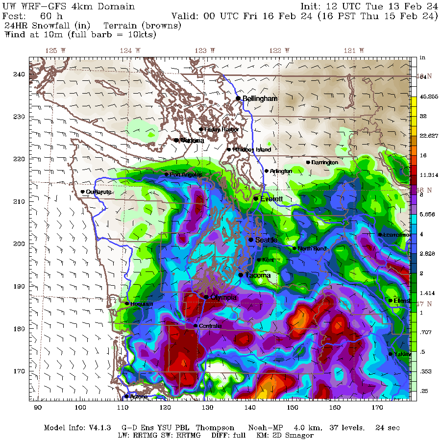
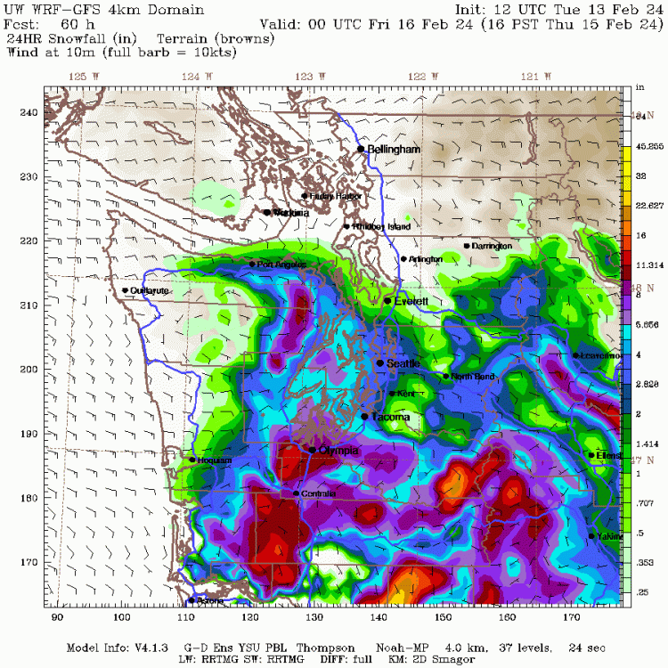
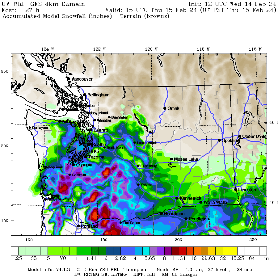
High-Res WRF continues to be quite generous for the Central and South Sound.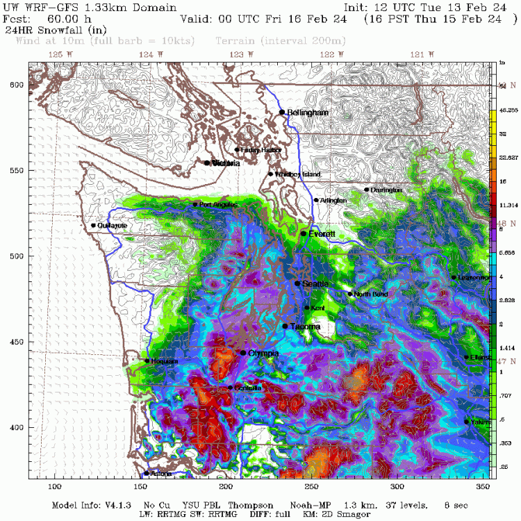
-
February 2024 Weather in the PNW
bainbridgekid replied to TigerWoodsLibido's topic in West of the Rockies
12z GFS gives Everett 0.03" in the next 9 days. Crazy how dry February has been here..thumb.png.3c366782da1efb99fddd9d1075b7a588.png)
-
February 2024 Weather in the PNW
bainbridgekid replied to TigerWoodsLibido's topic in West of the Rockies
6z Euro upped snow amounts noticeably. 10:1 map is always way too generous in borderline situations, but still good to see..thumb.png.e79b01c099230639bb1ff71bc04e593b.png)
-
February 2024 Weather in the PNW
bainbridgekid replied to TigerWoodsLibido's topic in West of the Rockies


.png.323fc441d847ff9816ebfb298fde4a2e.png)
.png.f3e725ca3c49822e9cf9494c626ba799.png)


.gif.d5c305ca339cd8709c65f06cad09fc4c.gif)


.png.ba4f42e2f0b5a412c1bac8a9ea48aa5f.png)

.png.adcb3e7809009bd08726b89f4aac8fd3.png)


.png.a438490fbebe499c8ff556479443d76a.png)

.png.2d8c32e252fdbd164c85425b2aa60e84.png)