

Gradient Keeper
-
Posts
27986 -
Joined
-
Last visited
-
Days Won
164
Posts posted by Gradient Keeper
-
-
32.9 with off/on flurries. Light N to E wind. Mmmm, hot chocolate with mini-marshmallows melted in it.
-
 5
5
-
 1
1
-
-
4 minutes ago, Kayla said:
The funny thing is none of the numbers were ever all that extreme for here. It was just for a while there in the beginning that the models thought the PACNW was Montana.
Yup!
-
4 minutes ago, Cascadia_Wx said:
The northern push of arctic air is beating the push through the Gorge at the moment. Im up in Salmon Creek right now and there’s a stiff north wind. The temp has fallen from 34 to 30 in the last half hour.
Yeah, the northern push had more momentum than I expected. It's just now nearing Troutdale from the east.
-
4
-
-
7 minutes ago, Olive1010 said:
Where's the arctic front now
From the north into PDX north of Division Street and just now pushing into Corbett from the east.
-
4
-
-
1 minute ago, Everleigh said:
Checking in from Yelm. I have about 4 inches of snow this morning. It started with the pellety type snow around 8:30pm, and it's still very lightly snowing now at 5am. No call from the school district yet though....

Wow 4 inches.... Very nice
-
3
-
-
5:03 am Arctic front just now into Kelso.
-
1
-
 2
2
-
-
4:23 am Arctic front through Castle Rock, and in the eastern Gorge through Rowena and Lyle now. Next up: Mosier, Hood River.
-
4
-
-
-
44 minutes ago, CasuallyFoxy said:
Pretty aggressive CAA through the gorge, The Dalles went from NW 9 to E 36 in 10 minutes.
Very much so. Comparing the progress of the arctic front with the 00z WRF 1.33km it's right on schedule. The boundary moving in from the north is a bit behind modeling though just north of Castle Rock. The fact the WRF is doing that well with the backdoor front into the eastern Gorge means it may be quite close with pressure gradient forecasts and if so, areas east of I-205 especially Gresham, Troutdale, Fairview, Wood village are going to see very strong possibly damaging winds. Another area of similar winds for the Foothills up into Clark County and even the West Hills. There is the potential before this east wind storm is over that we could see the strongest east winds in 20-25 years.
12z GFS in 4 hours 7 minutes
-
2
-
-
1 am 850mb temps. That's impressive! Now imagine if that ridge had held for another 1-2 days. Top tier blast without a doubt.
-
7
-
-
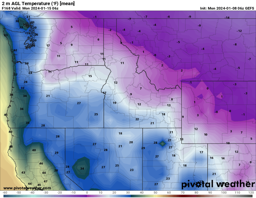
Wow 12z EPS mean temp PDX for Saturday 20/14 .... Bitter cold!
-
8
-
-
12 minutes ago, GobBluth said:
14 degrees with 850 temps above 0?
Bitter low level cold/925s
-
3
-
-
18z NAM 4 pm Tuesday (12-run trend) Nice trend to amplify the ridge and watch the base of the block closely scoot further west a notch.
.thumb.gif.28946dfb3bced07484f04cbe921cb9fb.gif)
-
3
-
-
Not bad.
-
1
-
 1
1
-
 1
1
-
-
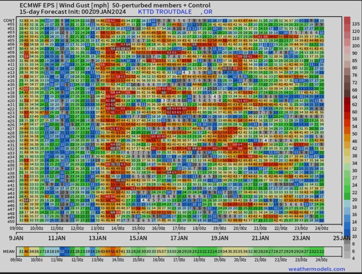
59 minutes ago, Ken in Wood Village said:
Just looked at the 00Z EPS winds for my area. Looks like I'm in for a major windstorm event this weekend. Check out some of the members. Some are over 70 mph
 🌬
🌬

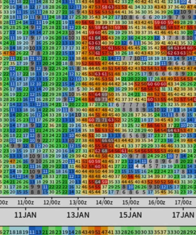
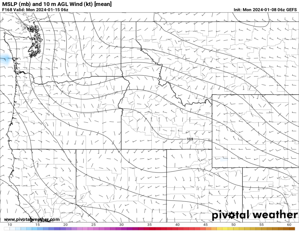
I've never seen anything like this for an ensemble for east winds. Ever. The ECMWF Op IF it's correct would produce a damaging east wind storm, but not just gap, downslope as well. 4 am Saturday the PDX-DLS gradient is at least -14mb and the Cross Cascade OTH-GEG gradient at a staggering -29mb! The criteria typically where we look for downslope wind storm potential is -24mb. This needs to be watched very closely. Oh, and this occurs as an arctic blast is underway with temps plummeting.
-
8
-
-
This wraps up this episode of the Night Shift. Cya later today. Root for improved 12z runs!
12z GFS in 4 hours 4 minutes
12z ECMWF in 6 hours 14 minutes-
3
-
 1
1
-
-
Wednesday 6-10 am PDX finally warms to 33-35 F that is assuming the model isn't trying to moderate us too quickly. That depends on east wind though.
-
1
-
-
Jeez 10 PM Tuesday and PDX still hasn't moderated at 30 F.
-
2
-
-
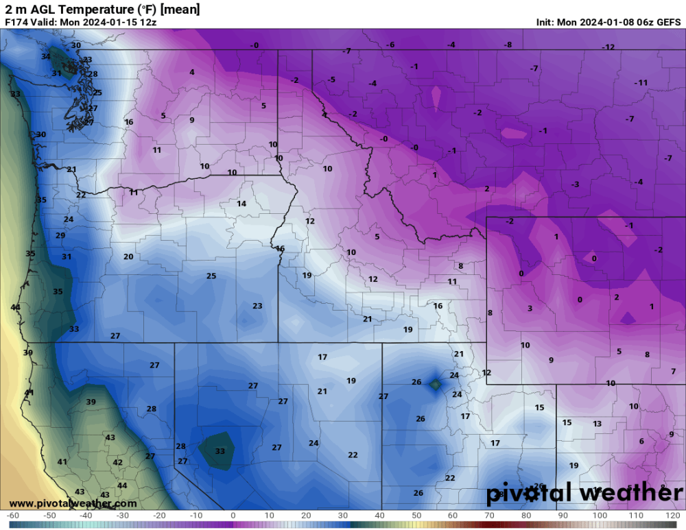
4 am Monday fresh batch of low level arctic air spills far down the valley even.
-
4
-
-
East wind increases Sunday evening keeping PDX in the freezer.
-
2
-
-
Jeez PDX back down to 24 by 10 pm Sunday! Puget Sound all cold!
-
5
-
-
MOAIS Mother of All Ice Storms

-
 1
1
-
-
The 6z GEFS has a very similar theme as the 6z GFS. It looks like temps at PDX fall below freezing 4-5 PM Friday and plummet into the 20s through Sunday morning at least as a lot of precipitation arrives. It's unclear how much of that is snow, sleet, or freezing rain.
-
2
-
-
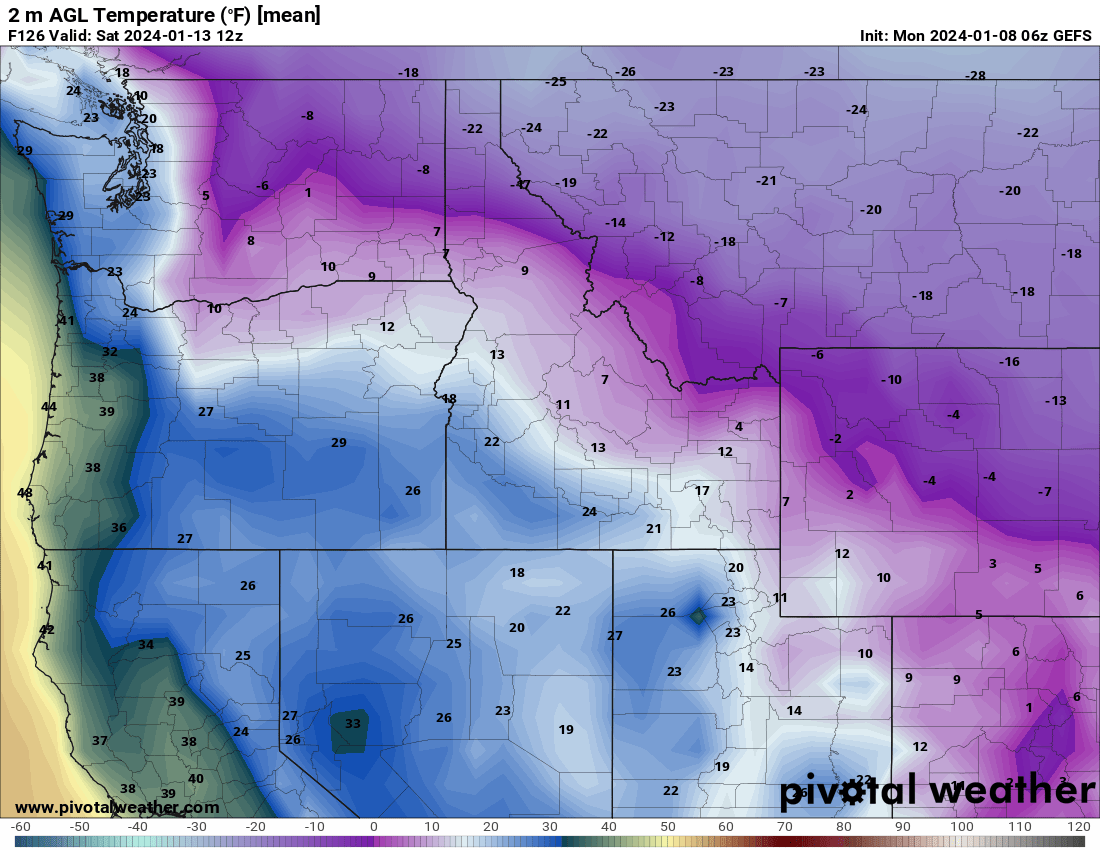
GEFS is plenty cold.

-
6
-
1
-

.gif.766f77f674fc343215ca1b3f406897fd.gif)


February 2024 Weather in the PNW
in West of the Rockies
Posted
It looks like we just may score again in February. Dramatic shifts on the ECMWF, GEM, and EPS tonight. Day 3.5 to 6.5 major improvement. Day 7+ love that PV retrograding through the Canadian prairies edging towards northeast Washington. Big things coming. MBG!
Night Shift 6z GFS in 1 hour 23 minutes