

Gradient Keeper
-
Posts
27986 -
Joined
-
Last visited
-
Days Won
164
4 Followers


About Gradient Keeper
Recent Profile Visitors


Gradient Keeper's Achievements
")


-

February 2024 Weather in the PNW
Gradient Keeper replied to TigerWoodsLibido's topic in West of the Rockies
It looks like we just may score again in February. Dramatic shifts on the ECMWF, GEM, and EPS tonight. Day 3.5 to 6.5 major improvement. Day 7+ love that PV retrograding through the Canadian prairies edging towards northeast Washington. Big things coming. MBG! Night Shift 6z GFS in 1 hour 23 minutes -
January 2024 Weather in the PNW (Part II)
Gradient Keeper replied to Meatyorologist's topic in West of the Rockies
32.9 with off/on flurries. Light N to E wind. Mmmm, hot chocolate with mini-marshmallows melted in it. -
January 2024 Weather in the PNW (Part II)
Gradient Keeper replied to Meatyorologist's topic in West of the Rockies
Yup! -
January 2024 Weather in the PNW (Part II)
Gradient Keeper replied to Meatyorologist's topic in West of the Rockies
Yeah, the northern push had more momentum than I expected. It's just now nearing Troutdale from the east. -
January 2024 Weather in the PNW (Part II)
Gradient Keeper replied to Meatyorologist's topic in West of the Rockies
From the north into PDX north of Division Street and just now pushing into Corbett from the east. -
January 2024 Weather in the PNW (Part II)
Gradient Keeper replied to Meatyorologist's topic in West of the Rockies
Wow 4 inches.... Very nice -
January 2024 Weather in the PNW (Part II)
Gradient Keeper replied to Meatyorologist's topic in West of the Rockies
5:03 am Arctic front just now into Kelso. -
January 2024 Weather in the PNW (Part II)
Gradient Keeper replied to Meatyorologist's topic in West of the Rockies
4:23 am Arctic front through Castle Rock, and in the eastern Gorge through Rowena and Lyle now. Next up: Mosier, Hood River. -
January 2024 Weather in the PNW (Part II)
Gradient Keeper replied to Meatyorologist's topic in West of the Rockies
-
January 2024 Weather in the PNW (Part II)
Gradient Keeper replied to Meatyorologist's topic in West of the Rockies
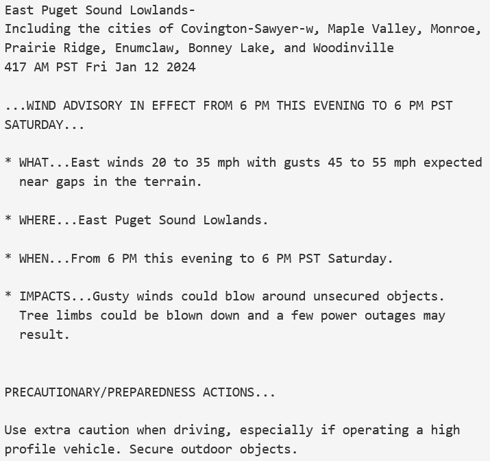
Very much so. Comparing the progress of the arctic front with the 00z WRF 1.33km it's right on schedule. The boundary moving in from the north is a bit behind modeling though just north of Castle Rock. The fact the WRF is doing that well with the backdoor front into the eastern Gorge means it may be quite close with pressure gradient forecasts and if so, areas east of I-205 especially Gresham, Troutdale, Fairview, Wood village are going to see very strong possibly damaging winds. Another area of similar winds for the Foothills up into Clark County and even the West Hills. There is the potential before this east wind storm is over that we could see the strongest east winds in 20-25 years. 12z GFS in 4 hours 7 minutes -
January 2024 Weather in the PNW (Part II)
Gradient Keeper replied to Meatyorologist's topic in West of the Rockies
1 am 850mb temps. That's impressive! Now imagine if that ridge had held for another 1-2 days. Top tier blast without a doubt.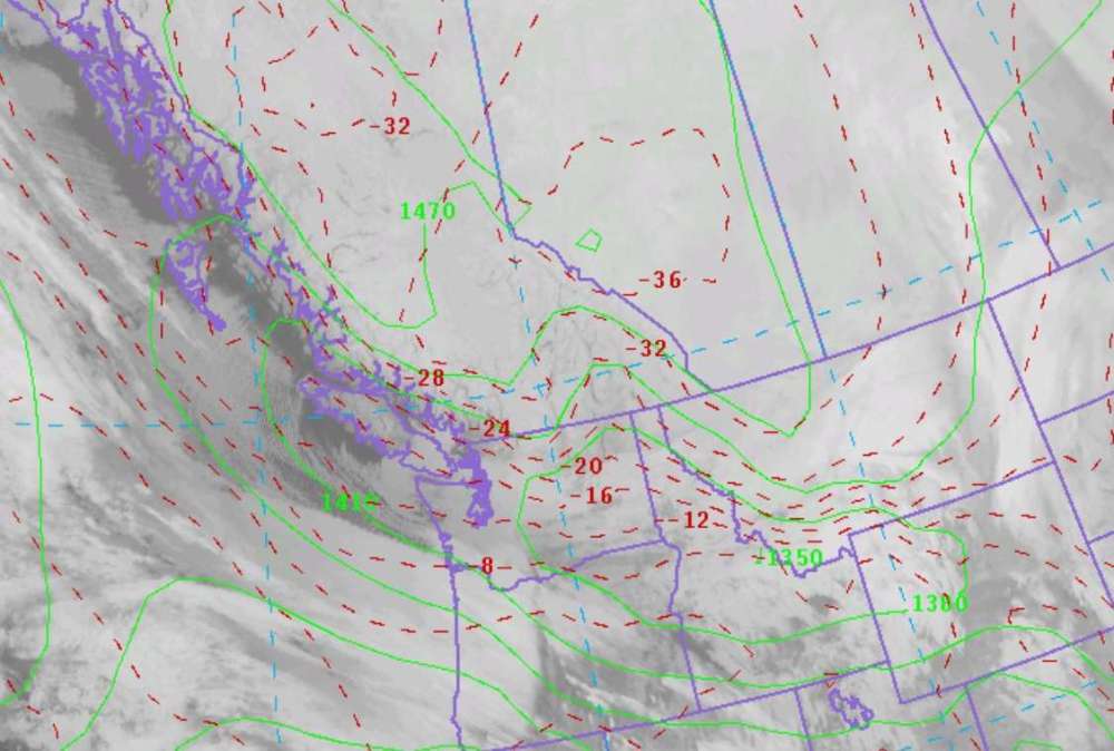
-
January 2024 Weather in the PNW (Part II)
Gradient Keeper replied to Meatyorologist's topic in West of the Rockies
Wow 12z EPS mean temp PDX for Saturday 20/14 .... Bitter cold! -
January 2024 Weather in the PNW (Part II)
Gradient Keeper replied to Meatyorologist's topic in West of the Rockies
Bitter low level cold/925s -
January 2024 Weather in the PNW (Part II)
Gradient Keeper replied to Meatyorologist's topic in West of the Rockies
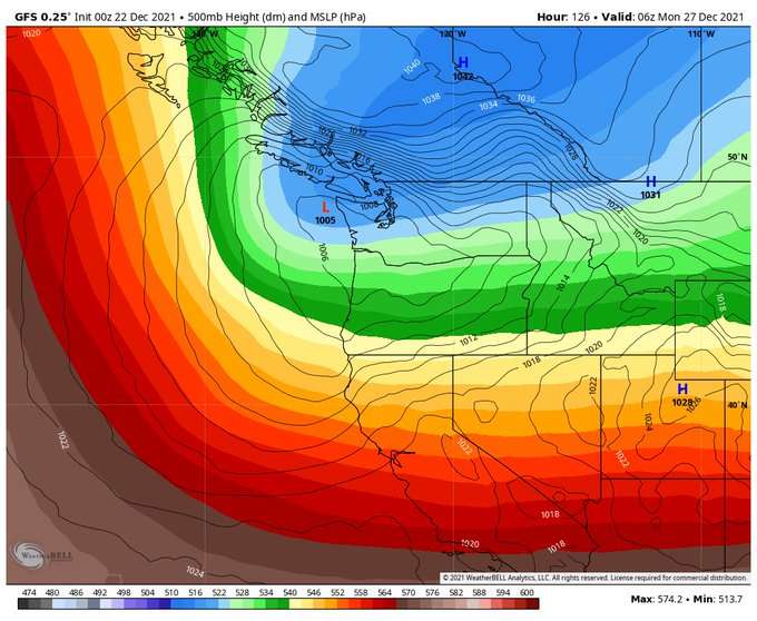
18z NAM 4 pm Tuesday (12-run trend) Nice trend to amplify the ridge and watch the base of the block closely scoot further west a notch..thumb.gif.28946dfb3bced07484f04cbe921cb9fb.gif)
-
January 2024 Weather in the PNW (Part II)
Gradient Keeper replied to Meatyorologist's topic in West of the Rockies
Not bad.


.gif.766f77f674fc343215ca1b3f406897fd.gif)

