


Cascadia_Wx
-
Posts
7137 -
Joined
-
Last visited
-
Days Won
25
Posts posted by Cascadia_Wx
-
-
1 hour ago, Meatyorologist said:
Good question, I'm not entirely sure myself, though I do have a good idea why ground observations in the intermountain west don't have as much of a lag. These stations are at ground level surrounded by similar or more prominent high elevation terrain, so there is lots of surface heating. A city like Denver for instance is going to be receiving air from upstream deserts where 100s of miles of high elevation terrain have warmed the 800-400mb column to the dry adiabat. This effect tracks most prominently with sun angles, thereby offsetting the upper level seasonal lag by few weeks.
An influx of monsoonal moisture may play a significant role as well, since it comes in right around or just after the solstice, and lowers max heating potential considerably, especially in AZ, UT, and NV.
I'd imagine prominent peaks along the coast such as Whitney or Shasta or Rainier max out in temperatures around August since they are consistently exposed to unmodified high altitude marine air. Pikes Peak in CO on the other hand may top out earlier, but I'm not sure.
I’ve thought about this sort of thing a lot my self. It seems like relatively isolated areas of elevation (a mountain range like the Cascades or Sierras) are much more subject to the lag than broad areas with elevation (like the Colorado plateau). Even though these areas are high they get heated a lot more evenly and act as the “surface”, albeit elevated. I’ve looked at 850mb temp charts for places like Denver or Santa Fe before and it’s interesting how well 850s track with the diurnal cycle in these locations, as opposed to their relative consistency in our area, decoupled from the surface
-
 3
3
-
-
1 minute ago, Omegaraptor said:
Looks like Hillsboro just barely missed a freeze with a low of 33. Corvallis and McMinnville both got to 34.
Six hour lows come out around 11am
-
3
-
-
40 minutes ago, Eujunga said:
But you're saying that all things being equal, temps at the 700mb level tend to warm more slowly in the spring than they do at the 1,000mb level, for example? It's just interesting to me, as I hadn't heard about that effect before.
There’s lots of factors but I’ve always been under the impression that the atmosphere is generally warmed from the bottom up. Which is short answer why places with elevation are colder overall. So the lag thing makes sense since it would take longer for heat to propagate up through the atmosphere, on top of the existing seasonal lag that even the surface experiences
-
2
-
-
Low of 37 here this morning despite mostly overcast skies. Pretty impressive
-
5
-
-
- Popular Post
- Popular Post
Keeps getting better
-
10
-
29 minutes ago, Omegaraptor said:
Latest first 80 on record at PDX is June 12, 2010. Could be a record to watch?
Also keeping a close eye on that record low annual max from 1954. It’s already May 8th. We’ve practically got it in the bag at this point.
-
Also, for the record, PDX had a ridiculously late 50 degree max on 5/22/13
-
1
-
-
23 minutes ago, Deweydog said:
Latest sub-53 degree max at PDX since 2003 when they managed a 52 and 51 on the 16th and 17th.
To put that in perspective, Shia LaBeouf was starring at that time as a pubescent scofflaw in the movie Holes. IT’S BEEN A LONG TIME.
They hit 53.
-
1
-
 2
2
-
-
7 minutes ago, TigerWoodsLibido said:
About -7F here or so. Wish we got more -10F or better more often but we're just a bit too far south.
There were widespread -15 to -20 departures to your south today
Your daily departure was about the same as SEA’s
#cognitivedissonance
-
1
-
 1
1
-
-
5 minutes ago, Omegaraptor said:
Beat me to it. Although the high of 39 in Klamath Falls is a -26 departure.
Lakeview and Sunriver also ended up with highs of 39.
Figured I was stealing your thunder there. It’s been clear for years your true heart lies in some semi-arid corner of Siskiyou county
-
 1
1
-
-
1 minute ago, snow_wizard said:
Nice to see we can still put up a region wide major cool period.
Kind of scary looking at the ytd and water year to date deficits for those Northern California spots, though.
-
-15F departure for Medford, Oregon today with a 50/38 spread. Same spread for for Roseburg which put up a -14 departure.
Biggest departure I could find in the area covered by NWS Medford was 19 degrees below the daily average in Montague, CA. That included a record low of 24 which beat the previous record of 27. Mount Shasta City also had a record low with their 27 beating the previous record of 29.
-
6
-
-
1 minute ago, snow_wizard said:
SEA picks up a nice fat -8 departure today. 4 consecutive -7 or lower.
Weak sauce. -10 departure at PDX
-
1
-
 1
1
-
1
-
-
Assuming the 53 or 54 holds, today should end up PDX’s coldest high this late in the season since....2013
51/40 spread here with light rain in the morning giving way to scattered heavy showers and limited sunbreaks. Chilly day.
-
6
-
-
EPS looking good. A little break from the troughing later this week then we get another dip. Still no weeks of death ridging in sight, which sets this year apart from pretty much every year since 2013 at this point
-
6
-
1
-
-
PDX holding at 49 as of 1pm.
47 here, clouds are thinning a bit but it seems like more precip is rotating in rim the south
-
1
-
-
7 minutes ago, snow_wizard said:
Bloody cold for this time of year. This trough is a beast.
I’m sure clouds and precip are playing a role in keeping temps down there today

-
2
-
1
-
-
GFS ensembles looking good for another decent trough moving in around the 20th, after the current troughy period
-
5
-
1
-
-
12 minutes ago, MWG said:
What a Sunday! Currently 36F and raining.
The mountains of Southern Oregon and Northern California are going to get some more much needed snow with this system.
We are getting the deformation zone to the north of the ULL today. Just 45 with light rain currently. Could stay very chilly today if sunbreaks are limited later on.
-
2
-
-
12z GFS gives us a reprieve from the troughing later this week but gets really nice again in the long range.
-
2
-
-
A very cool 54/43 day here yesterday with scattered chilly showers.
Currently light rain and 44 this morning after a low of 40. Looks like some new snow fell on Larch overnight which is getting pretty low for this time of year. Happy Mother’s Day to all the moms on and off the forum!
-
6
-
-
59/48 day yesterday with over .80” of rain. Close to 2” for the month now.
Cooler airmass moving in this morning, overcast and 47 currently.
-
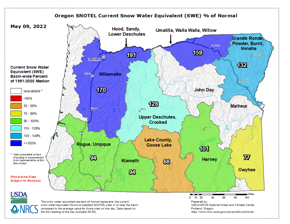
Looking like a nice shot of late season snow for the Cascades tonight through Monday. Some padding to the seasonal totals and should help make up for the very dry and sunny mid January through mid February period up there this year
-
2
-
 2
2
-
-
7 hours ago, Phil said:
Western-WA is cloudier than the majority of the country 10 out of 12 months in the year. Lowest annual UV index of anywhere else in the lower-48.
It’s a very cloudy climate. That’s just a fact.
And the Snoqualmie Valley up against the Cascade foothills is way wetter and cloudier than Seattle obviously. Probably closer to the west slopes of the Olympics. The rain/cloud shadow effect drops off quickly moving east from the Seattle metro
-
2
-

May Winter Continue 2022 PNW
in West of the Rockies
Posted
We’re way overdue for a washout Memorial Day weekend