


Cascadia_Wx
-
Posts
7178 -
Joined
-
Last visited
-
Days Won
25
Posts posted by Cascadia_Wx
-
-
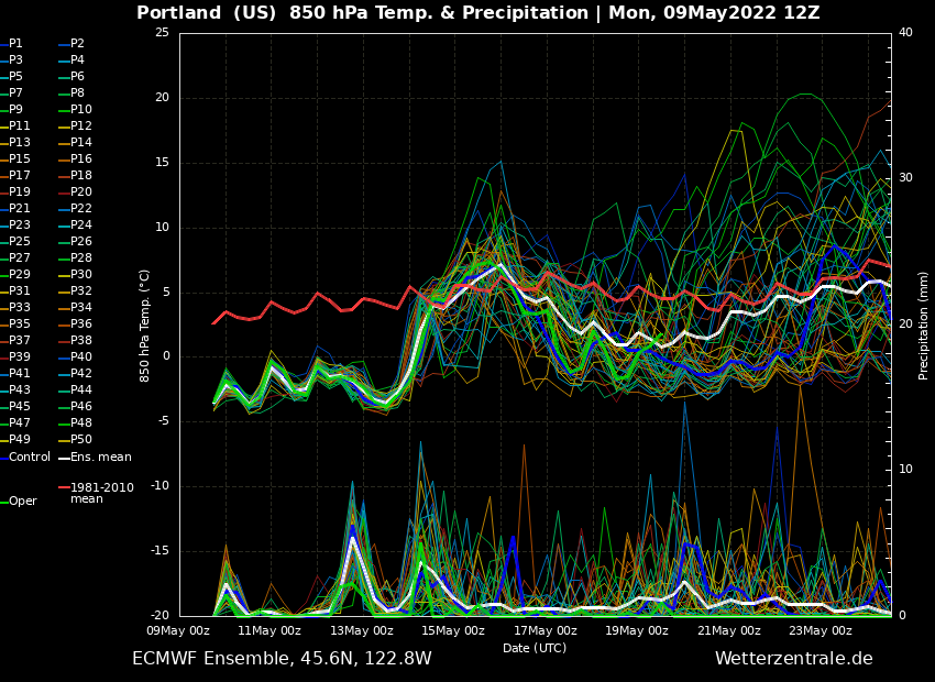
12z EPS was still showing a nice troughy period next week
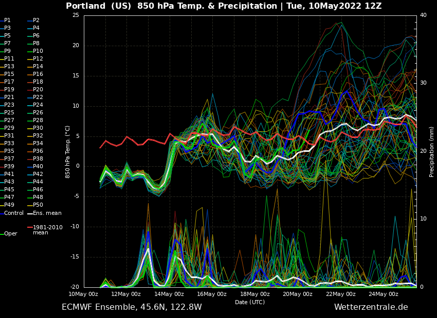
Mean rises a bit toward average after that but there are still plenty of cool and wet members in the mix
-
61/39 back at home with partly to mostly sunny skies and some big puffy clouds. Real stunner of a day.
-
 2
2
-
-
- Popular Post
- Popular Post
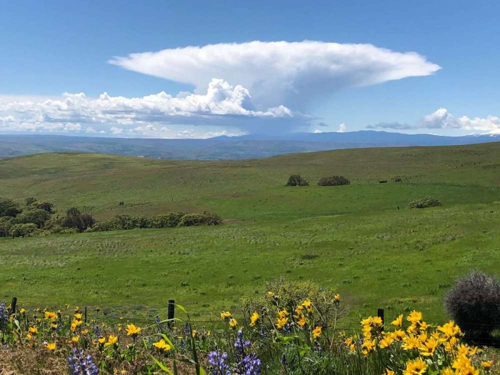
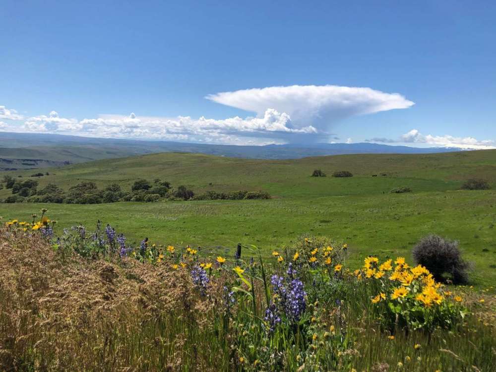
Classic anvil shaped thundercloud visible from Columbia Hills state Park this fine afternoon
-
15
-
 1
1
-
1 hour ago, SilverFallsAndrew said:
Don't worry, because 75% of people on this forum live within 30 minutes of Sea Tac, they will continue to discount our lived experience of last summer.
The bulk of heat related deaths were in the Puget Sound region up through SW BC iirc
-
5 minutes ago, SilverFallsAndrew said:
A lot of transplants here who do not realize this is normal spring weather.
It’s been on the cool and wet side but nowhere near as anomalous as the last ten or so warm seasons.
-
1
-
-
1 minute ago, The Blob said:
This will be some of you guys once it stops being cold


Last summer was about 35 degrees hotter than that. Killed a bunch of people.
-
Troughing isn’t as extreme as this week obviously, but that’s a pretty high bar for mid May.
-
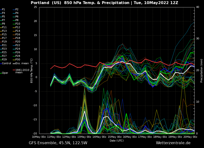
Next week still looking pretty troughy on the GEFS
-
3
-
 1
1
-
-
36 minutes ago, Omegaraptor said:
I’m not getting my hopes up yet but next week has trended much less troughy over the last few runs. Guess this pattern can’t last forever.
It will be time for a new pattern to complain about soon
-
 1
1
-
-
3 minutes ago, Jginmartini said:
43* and 2.30 precipitation for the month Federal Way
I have seen Spring….ya just need to travel to it
 ! Rowena Plateau trail (Columbia River Gorge) was not the place to find it though….chilly blustery winds. In wind sheltered areas of the hike it was quite lovely with the flowers blooming though.
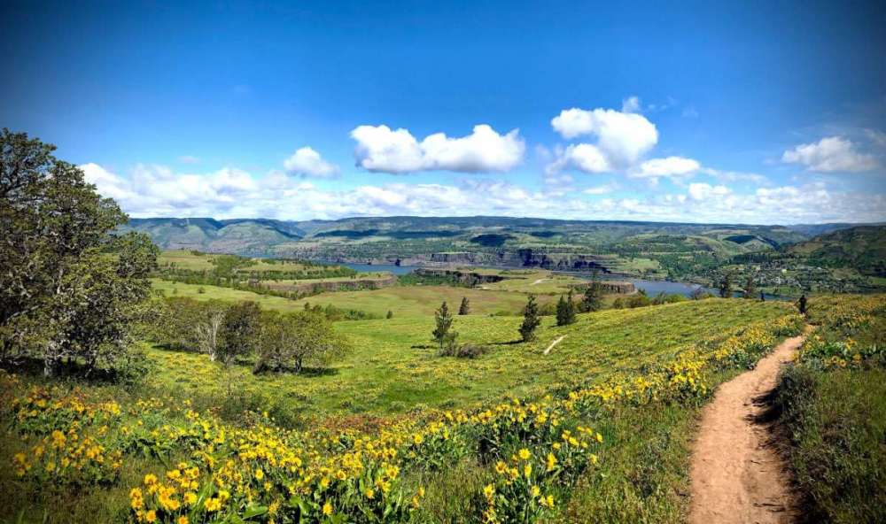
Chilly blustery winds with flowers
 blooming sounds like the epitome of spring in the gorge
-
1
-
-
Just a stunning morning out right now with the sun beaming down upon a lush, well watered landscape.
-
4
-
1
-
-
Mostly sunny and 43 this morning. Really pretty out. Got down to 39 earlier.
-
2
-
-
17 minutes ago, Omegaraptor said:
There are a lot of people here on my campus… and I haven’t met a single person even remotely happy about this weather. Just complaining. Believe me - my opinion of it is probably higher than most other people I know, if just for an appreciation of the anomalies we’re seeing out of some of these airmasses.
There’s gotta be at least one person here who is legitimately enjoying it and wants it to be cold and wet every day… but I haven’t met them yet.
Highly anecdotal observations like this usually seem to suffer from a lot of confirmation bias. We more readily see in others what we ourselves feel and tend to ignore information/evidence to the contrary.
-
2
-
 1
1
-
-
Just got a pretty gnarly hail shower here. Dropped the temp to 45 in the middle of the afternoon.
53/37 so far today. Another notably chilly one for so late in the season.
-
6
-
-
1 hour ago, Meatyorologist said:
12z Euro has mean blocking ridge position sliding right back over AK around the 20th. Models are also trending towards flattening this ridge and bringing warm rains instead of abundant sunshine to both OR and WA, particularly WA.
I’m not seeing the warm rains focused on Washington? But the 12z EPS definitely wants to move another trough in in the mid to long range.
-
1
-
1
-
-
29 minutes ago, bainbridgekid said:
It's amazing how the default setting has been thicknesses around 534-538 for the last several weeks and even more amazing there is still no clear end in sight. Hopefully things flip in a real way the last 10 days of the month.
We’re way overdue for a washout Memorial Day weekend
-
5
-
-
1 hour ago, Meatyorologist said:
Good question, I'm not entirely sure myself, though I do have a good idea why ground observations in the intermountain west don't have as much of a lag. These stations are at ground level surrounded by similar or more prominent high elevation terrain, so there is lots of surface heating. A city like Denver for instance is going to be receiving air from upstream deserts where 100s of miles of high elevation terrain have warmed the 800-400mb column to the dry adiabat. This effect tracks most prominently with sun angles, thereby offsetting the upper level seasonal lag by few weeks.
An influx of monsoonal moisture may play a significant role as well, since it comes in right around or just after the solstice, and lowers max heating potential considerably, especially in AZ, UT, and NV.
I'd imagine prominent peaks along the coast such as Whitney or Shasta or Rainier max out in temperatures around August since they are consistently exposed to unmodified high altitude marine air. Pikes Peak in CO on the other hand may top out earlier, but I'm not sure.
I’ve thought about this sort of thing a lot my self. It seems like relatively isolated areas of elevation (a mountain range like the Cascades or Sierras) are much more subject to the lag than broad areas with elevation (like the Colorado plateau). Even though these areas are high they get heated a lot more evenly and act as the “surface”, albeit elevated. I’ve looked at 850mb temp charts for places like Denver or Santa Fe before and it’s interesting how well 850s track with the diurnal cycle in these locations, as opposed to their relative consistency in our area, decoupled from the surface
-
3
-
-
1 minute ago, Omegaraptor said:
Looks like Hillsboro just barely missed a freeze with a low of 33. Corvallis and McMinnville both got to 34.
Six hour lows come out around 11am
-
3
-
-
40 minutes ago, Eujunga said:
But you're saying that all things being equal, temps at the 700mb level tend to warm more slowly in the spring than they do at the 1,000mb level, for example? It's just interesting to me, as I hadn't heard about that effect before.
There’s lots of factors but I’ve always been under the impression that the atmosphere is generally warmed from the bottom up. Which is short answer why places with elevation are colder overall. So the lag thing makes sense since it would take longer for heat to propagate up through the atmosphere, on top of the existing seasonal lag that even the surface experiences
-
2
-
-
Low of 37 here this morning despite mostly overcast skies. Pretty impressive
-
5
-
-
- Popular Post
- Popular Post
Keeps getting better
-
10
-
29 minutes ago, Omegaraptor said:
Latest first 80 on record at PDX is June 12, 2010. Could be a record to watch?
Also keeping a close eye on that record low annual max from 1954. It’s already May 8th. We’ve practically got it in the bag at this point.
-
Also, for the record, PDX had a ridiculously late 50 degree max on 5/22/13
-
1
-
-
23 minutes ago, Deweydog said:
Latest sub-53 degree max at PDX since 2003 when they managed a 52 and 51 on the 16th and 17th.
To put that in perspective, Shia LaBeouf was starring at that time as a pubescent scofflaw in the movie Holes. IT’S BEEN A LONG TIME.
They hit 53.
-
1
-
 2
2
-


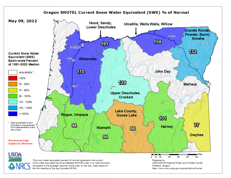
May Winter Continue 2022 PNW
in West of the Rockies
Posted
The GEFS has a monthly? Can’t imagine it being much better than the CFS