


Skagit Weather
-
Posts
2303 -
Joined
-
Last visited
-
Days Won
3
Posts posted by Skagit Weather
-
-
It didn’t get colder than 38F last night, but the small pond outside already has a decent layer of ice on it. I don’t think I’ve ever seen that before. DP is down to 23F though.
-
 1
1
-
-
Clear and 40F outside. I feel like before weather forecasts you'd really have no idea that by the end of the day temperatures will be almost 30 degrees colder.
-
 3
3
-
1
-
-
DP already dropped to 25F here about an hour ago, although it's currently back up to 28F with a westerly wind. It's really going to take a miracle to see any snow here. I don't think a single model shows it at this point, but I haven't given up hope yet.
-
4
-
 1
1
-
-
2 minutes ago, TT-SEA said:
Totally agree. HRRR also seems to underestimate precip coverage even during regular rain events even in near real time.
Yeah, In my experience the HRRR may be on of the worst models out there. It can't even forecast precipitation correctly an hour out let alone 1-2 days. I only use it to feel good about an event if it predicts snow although it usually has no basis in reality.
-
3
-
-
2 minutes ago, Front Ranger said:
Yeah, we already have seen that plenty of lowland snowfall is still very possible in this warming climate. The big question for some people is if a top tier blast was still possible.
That being said...snow is what brings people here.
Do we know what the qualifications are for a "top tier blast?" I mean are we looking for a subfreezing high all the way to Eugene or low temperatures in the teens over the same area or 850mb temps of -15C at SEA or what? I think we should establish a uniform set of statistics so that when it verifies we can highlight it instead of having a debate a couple years down the line about whether this was "top tier" or not.
-
4 minutes ago, AlTahoe said:
Early stages of this storm have been giving us brief whiteout conditions so far. Supposed to keep deteriorating into the evening.
Big avalanche off of the Kt-22 chair with 3 people missing. Palisades shut down for the time being.
That's terrifying. Inbounds is where you're supposed to be able to control you own fate (to some extent). Hope it turns out they're all right.
-
2
-
-
Saw that they were harvesting the last of the Brussels sprouts here yesterday in the valley. We've left root vegetables in the garden for the last couple of years even when temperatures dropped into the single digits, but that was always with a healthy snow cover. Might have to harvest a bunch of stuff before the flash freeze since we won't have any insulation this go around.
-
Hi-res WRF shows a decent chunk of moisture popping up overnight here. Unfortunately, at this time it's likely still too warm for snow here although @MossMan would get a decent dump of snow.
-
 1
1
-
-
6 minutes ago, Skagit Weather said:
Wow! That snow cover did wonders for you!
It didn't drop below 20F up here during that event and I didn't even have a subfreezing high. Here are the lows:
1/11: 20.1
1/12: 22.8
1/13: 20.6
1/14: 21.2
1/15: 23.5I would need to drop below 17.7F to set a January record low for my station (since 2010) and have a high below 24.8F to set a January record min-max.
Both of those I think are probably within reach.
-
5 minutes ago, Tyler Mode said:
My record lows tomorrow through Tuesday, all from 2017.
22.4, 2017 20.4, 2017 10.1, 2017 9.5, 2017 11.4, 2017 19.0, 2017 26.5, 2017 Wow! That snow cover did wonders for you!
It didn't drop below 20F up here during that event and I didn't even have a subfreezing high. Here are the lows:
1/11: 20.1
1/12: 22.8
1/13: 20.6
1/14: 21.2
1/15: 23.5-
2
-
1
-
-
22 minutes ago, TacomaWx said:
Might just be an Oregon event and us western Washington folks will have to see what it’s like being down there for once lol. We will see though going to be interesting!
For once? The 2010s were full of times Oregon did significantly better than WA. I mean even in the last few years they've had some crazy snowfall numbers (although obviously we've done better up here on the cold and lasting snow in the last few years).
If they end up getting heavy snowfall, I'll be ecstatic, but this isn't the first time with a possibility of them getting snow while we're left cold and dry.
-
4
-
 1
1
-
-
3 minutes ago, TT-SEA said:
Frigid on Saturday... teens with a snow in Portland.
Do you have min temperatures Saturday morning? It looks a bit chilly.
-
1
-
-
Ehhh...front passage was pretty tame here. Wind gusts to about 30 mph and 0.2" of rain over about 30 minutes.
-
Pretty wacky NWS point forecast for tomorrow morning here. I'm not sure any model is showing anything close to snow in the next 24 hours. Tonight before the front moved through and it bumped up to 50F, yes the snow levels were low. Wednesday morning, yes snow levels will be a couple hundred feet. But not Tuesday morning. I mean the temperatures should be in the 40s.
-
1
-
 1
1
-
-
1 minute ago, MossMan said:
2019.
That was a pretty weak niño. Michael Snyder showed it has only snowed twice in Seattle in the last 50 years during a strong niño.
-
36 minutes ago, SilverFallsAndrew said:
Yeah, does anyone think this could turn more into a January 2004 than a 1998? That was a bit more regional so to speak.
Also what do folks think about the 1980 analog? That one wasn't great for folks south of PDX, but there was a big arctic blast late in the month, that one was dry, but it would be cool to get another crack at it in a few weeks.
Going on basically nothing except the fact that this is a strong niño, I would be shocked if we get another chance this winter. I honestly feel pretty lucky to be seeing the mountain snow dump over the next few days and I’m just hoping it doesn’t get obliterated in a couple weeks by another warm atmospheric river.
-
2
-
-
- Popular Post
- Popular Post
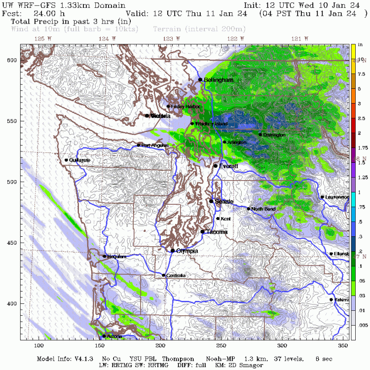
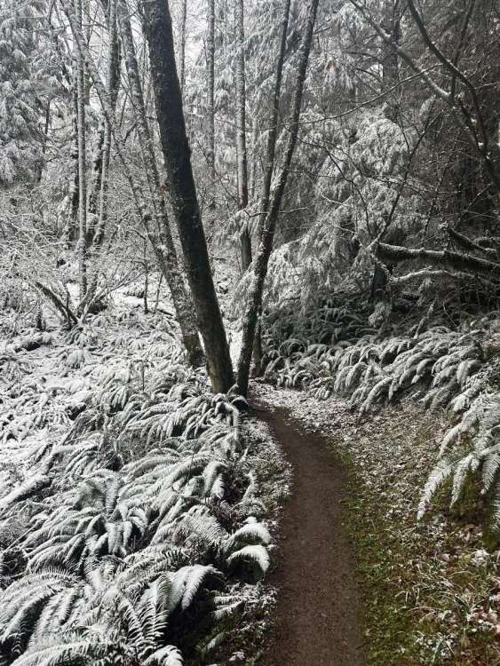
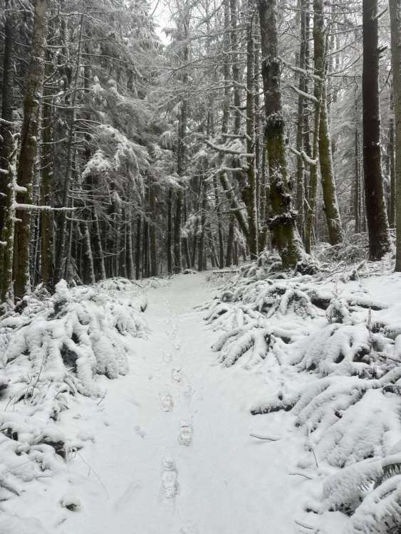
Went up Squak Mountain this morning. Snow started at 1,500’ and there was 3” at the summit. Certainly why we’re not seeing any sea level snow on the east side of Puget Sound
-
12
-
3 minutes ago, TT-SEA said:
The run ends at Thursday at 4 p.m. and was a little farther west than 00Z run.
.thumb.png.8f3c19c9aa21aa03983124b556dd6195.png)
Thanks! Looks maybe a bit faster with the cold air and a bit drier than the 00z up here.
-
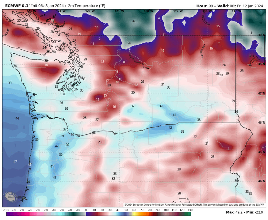
Anybody have access to the 06z Euro? Also nice to see that NWS looks to at least believe we’ll get a bit cold up here. Low temperature forecast for Fri/Sat is close to the single digits.
-
4
-
1
-
-
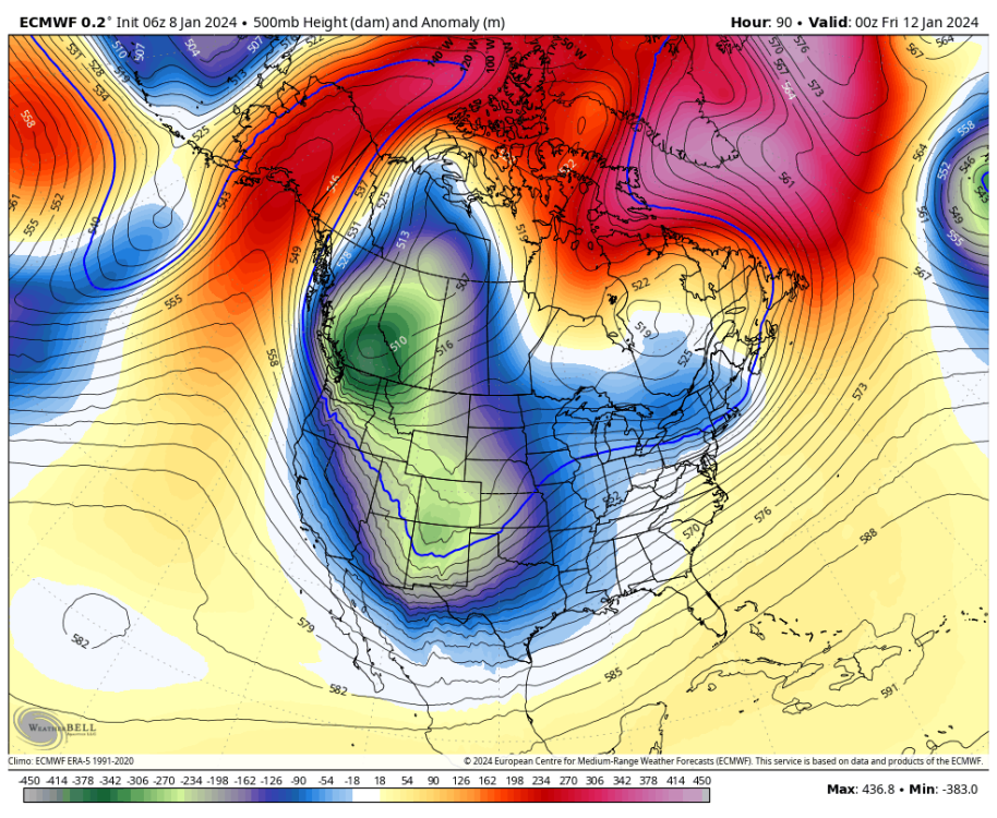
23 minutes ago, Rubus Leucodermis said:
ECMWF 6 days out on the Dec 2021 cold snap, just to temper expectations.
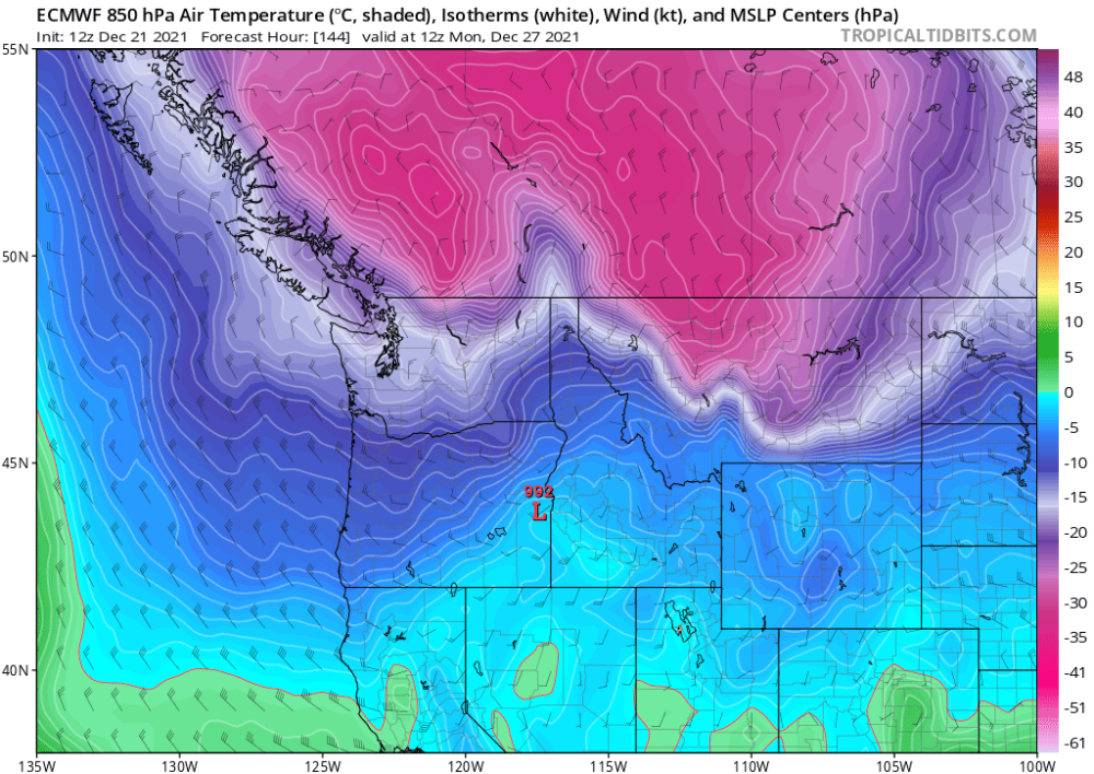
Looks like it bottomed out at -10.7C at 850mb at Quillayute on the 27th (which was the coldest reading) in December 2021 so maybe the Euro was 2-3ºC too warm with this -13 or -14C forecast? Honestly I would be pretty happy with a 2021 repeat.
For reference the 138 hour forecast for the Euro tonight shows 850mb temps dropping to -16 or -17C at Quillayute for this event so maybe 3-4C colder if it verified with the same error.
-
1
-
-
39 minutes ago, Port Angeles Foothiller said:
This graphic…
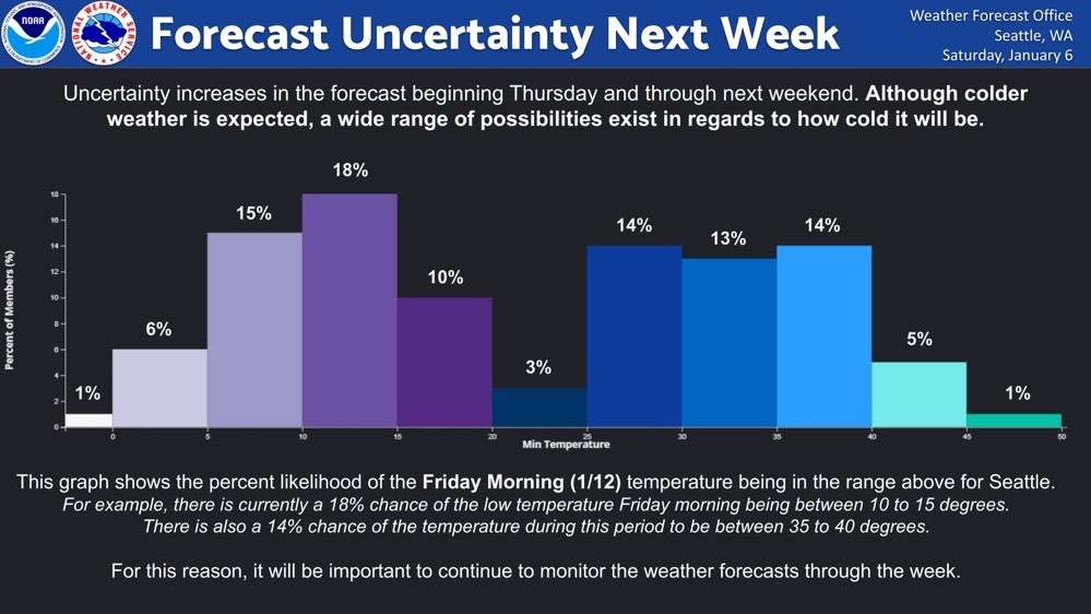
I generally like the NWS attempts to communicate uncertainty, but in my opinion this is kind of ridiculous and perhaps one of the worst ones I've seen if you're considering the audience is the general public. One reason is simply design complaints. You can barely read the temperatures at the bottom. I have good eyes and I had to get out my magnifying glass. It's like when the graph was created they weren't sure how to change the font size of the x/y labels.
Also, this is incredibly confusing. I have been following weather for decades and the run-up to this storm for days and it took me a minute to understand what this was implying. I mean it looks like they took all the minimum values from the ensembles (I don't know if it's GFS, NBM, Euro, or a combination) on Friday morning (1/12) at 12z and put them into buckets. It looks to me that based on the model they're using there's a 20% chance for the low temperature to be in the single digits or below and a 20% chance for it to be above 35F, but I can guarantee most people are not going to take that information from this. As a weather nerd, I think it does a decent job showing the separation between the warm ensembles and cold ensembles, but there's no additional discussion about that to give context to people not heavily invested in it.
Finally, this is for a single location (I imagine SEA), one of the warmest in the entire state during Arctic outbreaks. But most people who are going to see this have no idea about that. Maps are much better to convey this sort of temperature information and are a more standard method because they address regional climate differences. If they wanted to focus specifically on Seattle they could chose a much better method than this histogram.
My understanding is there are accepted graphic templates that are handed down from on high (changing each year) to each NWS forecast office and the meteorologists in each office can decide which ones to use to communicate forecasts with the general public. I'm pretty sure NWS Seattle is not responsible for the design of the graphic, but it's a questionable choice to distribute.
-
2
-
-
At the very least, even if it doesn't snow in the lowlands, the mountains look to get buried. That's a win in my book for a niño.
-
4
-
-
Ugh...not that it's going to happen in any shape or form, but I really hate overrunning events. Definitely my least favorite type of snow setup. I can't recall the last overrunning setup that produced decent snow here. Almost every time I'm shadowed for hours while it's snowing all around me, and then finally when the precip gets here it falls as rain and all the snow melts remarkably quickly.
In the last 15 years I'm not sure I've picked up more than 2" (if that) from an overrunning event. Of course that's not what any model shows at the moment, but I just hope the only snow chances don't come down to overrunning.
-
1
-
-
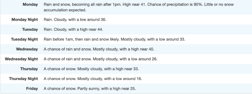
It's within NWS point forecast now! This is for just north of Bellingham with a forecast high in the mid 20s next Friday. I still have my doubts, but I'm starting to get a little excited.


.png.94c0ab5cf77dde684ed4a267cb03fabe.png)


January 2024 Weather in the PNW (Part II)
in West of the Rockies
Posted
North wind looks like it just arrived here in Skagit. Temperature is down a couple degrees from 44F earlier.