


whatitdo
-
Posts
146 -
Joined
-
Last visited
Posts posted by whatitdo
-
-
@jaster220 looks like you got that winter storm warning! Congrats man
-
 1
1
-
-
29 minutes ago, tStacsh said:
The Hi Rez euro gives me a dusting. The gfs is barely worth mentioning. GRR is being realistic. I think you’ll do decent 3-4” at the worst but these maps showing a foot in SMI are insane and not worth taking seriously. Otherwise the GRR NWS should look for a new job.
Looking forward to the forecast discussion at 330 to say the least lol. Idt ive ever seen such disparity
-
 2
2
-
-
4 hours ago, Tom said:
Boom! LOT pulls the trigger and issues a WSW for heavy snow across Cook county with 4-8” of snow expected.
Wow awesome. Im so confused as to why GRR downplaying this so much to the point that it’s an event not even worthy of any headline
-
 2
2
-
-
3 hours ago, Stacsh said:
Depressing for Michigan. Oh well. Enjoy it to the south and east. Big winners there. Midwest/GL going to get shut out, then it's almost March. Bring on warm and Thunderstorms. We need a warmer, more active Spring for once!!!
Still waiting on a big dog here in kzoo - no snows more than 3.5 inches for any 24 hr period! Misses west, east, north, south or systems lose umph when they get here. But still more season total snowfall ive probably ever had. At least you had that 8 inch day on the 5th!
-
1
-
 1
1
-
-
16 minutes ago, Grizzcoat said:
Glacier!!!

lolwut. that's crazy
-
 1
1
-
-
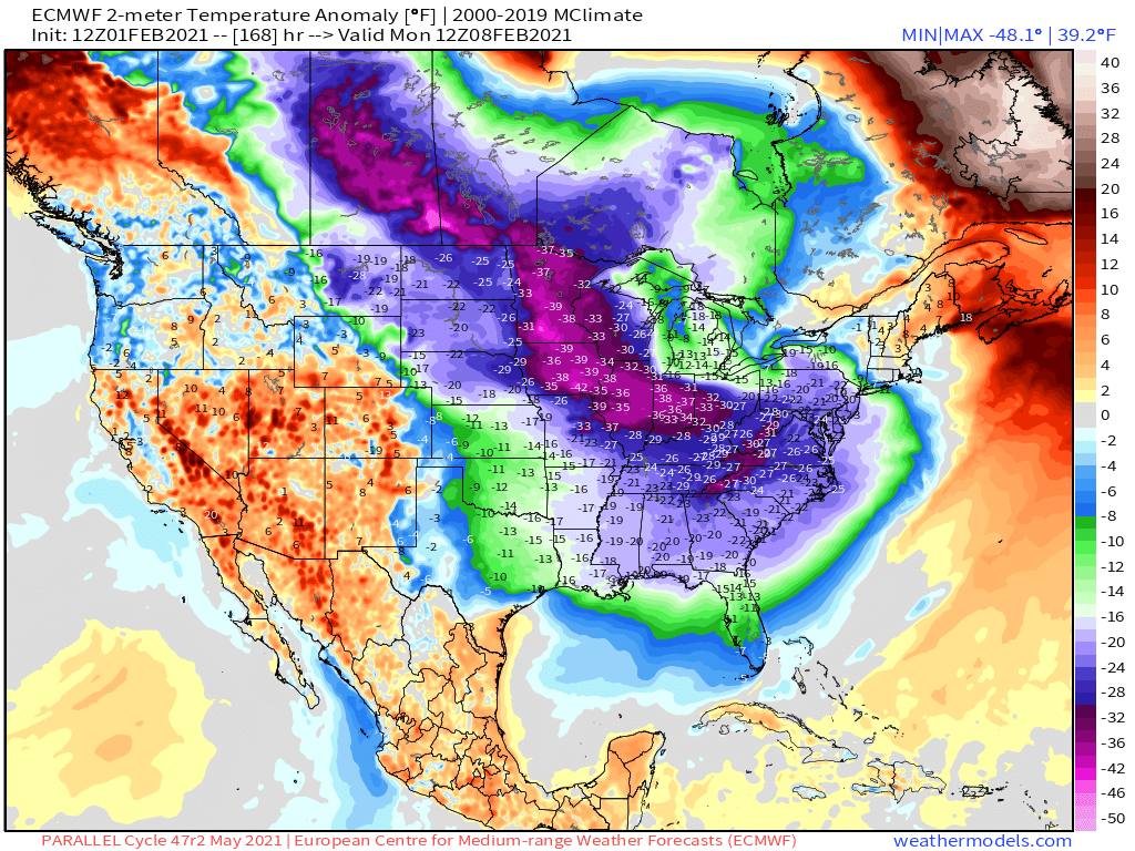
Does NWS take into account LES when they forecast below normal precip for a good majority of the cold snap?

Just curious because weather app (which i never really look at) went from showing snowflakes to just cloudy for mby
-
1
-
-
58 minutes ago, tStacsh said:
My sweet spot is due west or WSW wind. I should do well with how strong it may be
1 hour ago, jaster220 said:Can't really remember the last time we had this kind of bombing SLP taking this (or any) track during the winter months. Trying to draw a picture of this in my mind's eye is proving a bit challenging tbh. Which is a good thing. I'd say that the Hybrid storm during late January of 2019 was probably a good comparison for areas NW of here. We got the initial system snow but the following PV-driven lake effect bliz screwed us when the winds never got fully west but remained WSW. Have fears with a repeat of that for here this time as well. Nonetheless, this has an actual deepening SLP and the low baro should really provide for some great lift and dynamics. Friday will rock for those fortunate enough to get a favorable fetch off the lake. I expect to ride my familiar fringe yet again.
Kzoo does well with NW and WNW I believe. How do yall think the lake effect for Sunday-Monday looks? Better than Friday? Man I may have to call in sick and weenie it up on friday lol
-
 1
1
-
-

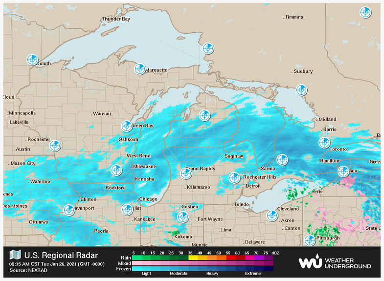
yikes.
though the brunt of the cold misses michigan this run, im assuming thats still a great signal for LES @Stacsh
-
36 minutes ago, Stacsh said:
Should we do separate threads? One for the surface low and one for the Arctic cold/LES behind it? I'm all for the WAA part of the event, but I'm more excited for the LES potential and don't want to talk about that only on here.
Yes please fire up a LES thread
-
1 hour ago, Jarod said:
Well we might finally get some lake effect over here ... although if it gets as cold as the models are showing, it will probably be tiny flake size and not add up real well.
4 minutes ago, Stacsh said:Lakes are still relatively warm. With enough cold air and moisture it will add up over time. This will no doubt be our snowiest month, even without a major storm/s
what extent of cold do we want for moderately sized flakes? The forecasted cold coming down looks a bit similar to 2019
-
1
-
-
53 minutes ago, jaster220 said:
Still in Baton Rouge. Any reports from my SWMI Peeps??
3 inches here! Best of the season lol. All snow has stopped though
-
1
-
1
-
-
Initial call of 4-6 inches for kzoo yesterday is going to bust. Nws hourly forecast only shows up to 2 inches. If I get 3 with being able to see some flakes fly at daybreak, ill be happy. It’s looking less and less likely though. Lame. @jaster220
-
1
-
-
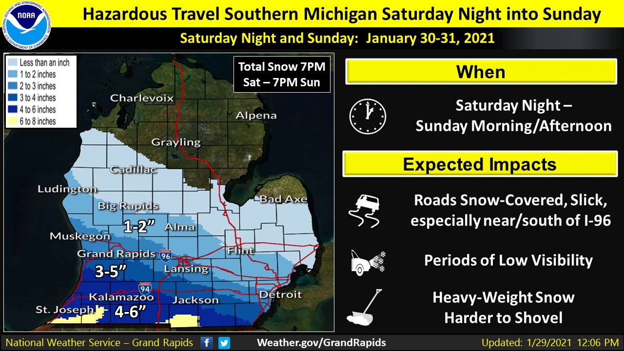
28 minutes ago, jaster220 said:
DISCUSSION...(Today through next Thursday)
Issued at 236 AM EST Fri Jan 29 2021

- Impactful snow event for parts of the area Sat night - Sun

Many of the latest runs continue to support several inches of snow
for the southern couple of rows of our CWA...generally south of
Interstate 96 with the next storm system. This is the region that
is expected to see the deepest moisture and most favorable
dynamics with this storm system.  However the GFS continues to
show accumulating impactful snow further north with this storm.
Meanwhile the Canadian GPDS suggests we could make a run a
warning snows down south...but this model is an outlier at this
time. Based on all this...it appears we are heading toward an
advisory event for southern and perhaps central parts of the
CWA...so no watch at this time. We will need to continue to
monitor the storm closely as tracks out of CA and into the Central
Plains.
This would be our biggest snowfall of the year. GRR NWS ftw!
-
 1
1
-
-
19 minutes ago, Stacsh said:
Too bad this storm just dies as it runs into Michigan.

been the theme all winter. didn't even need to wishcast lol i knew where this was headed from the jump smh
-
1
-
-
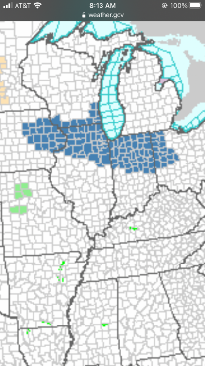
West Michigan this winter watching everyone else get winter storm watches/warnings

-
4
-
 1
1
-
-
1 minute ago, Sciascia said:
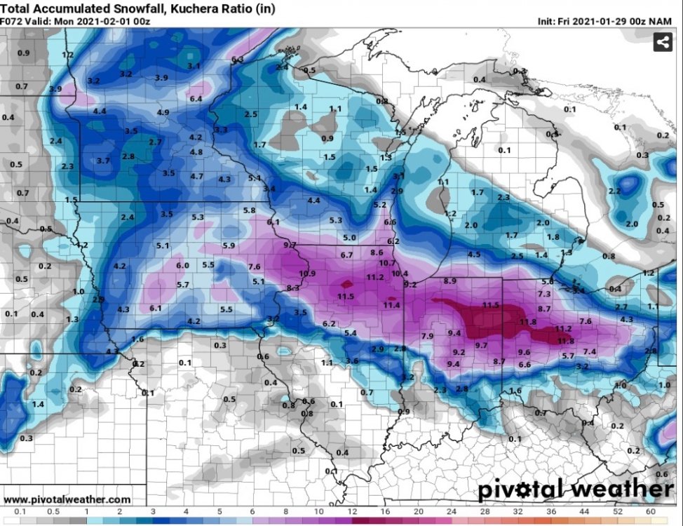
that gradient in south michigan is cruel. 5 inch difference down a row of counties. bump up north please
-
 1
1
-
-
7 minutes ago, Grizzcoat said:
This is NE /E IA into N.IL storm for max. Ring it up.
how do you think kalamazoo area will do this go round?
-
1 minute ago, Stacsh said:
GRR: Not one model I've seen has high snow impacts along I-96 in Michigan. Am I missing something? Is this going North and the models aren't showing it yet?
- Trend toward higher potential for impacts Sat Night - Sun

Models are coming into better agreement with the coverage and
location of the snow with the next storm system for Sat Night into
Sunday. Overall the latest guidance is favoring accumulating snow
across much of the central and southern parts of the CWA. Highest
amounts are shown to be along and south of I-96. Impacts are
looking increasingly likely...with several inches of snow now
possible. This system could continue to trend upward from an
impact perspective with time as models are now starting to show
better FGEN and some Gulf moisture getting drawn into it. Based on
this we will increase POPs to likely or higher for these
locations and add a few inches of snow to the forecast.
i saw that. you know, they were the first in the area to say heaviest snow amounts would be north of i94 (instead of south) for the last system.
-
I just want a snowfall greater than 3 inches. Is that too much to ask? I haven't had a day with more than 2 inches of 24 hr snowfall yet
-
1
-
1
-
-
Can someone post the 18z eps mean for michigan?
-
1 hour ago, Stacsh said:
The storm ongoing did also. 3 days ago there was no chance of snow in MId-Michigan and they got 3-8" so far. Time will tell.
4 minutes ago, Stacsh said:Like this previous storm, it's overplaying the blocking this far out.
I may be bitter and I hope im wrong but I honestly don’t think I will be. Using my jedi instincts on this and it just doesn’t feel like it will pan out despite what happened with todays system. Gotta be different variables at play. Ik @jaster220 feels me lol-
1
-
-
Ofc it hits a brick wall on its way over here ¯\_(ツ)_/¯ i give up lol
-
1
-
-
12 minutes ago, jaster220 said:
Sorry to say but Euro's been complete trash for here!
Essentially been following this threat/promised pattern shift (and storm) for what amounts to at least 3 weeks.
What did I get for all that time spent? Another lousy <1" snowfall. Ooof!
And what about all that talk of how this would be suppressed over here due to "the confluence". LOL
As pointed out by Stasch, "what suppression?"
Same places that have scored all season are scoring again. Nature will find a way.
As totally awesome as 13-14 was here, this is the total opposite dumpster fire season.
Glad at least you've gotten a decent storm tho, enjoy it!
i really cant believe it got that far north in michigan. they were saying the heaviest amounts would be along i94 or between i94-96. just crazy that we have to follow models the day before event and it still doesnt pan out
-
3
-
-
2 minutes ago, GDR said:
So is the Canadian showing from both?
no he posted just this thread's system (for the canadian)


Valentines and Presidents Day Oklahoma and Mid West Smasher.
in East of the Rockies
Posted
Got about 6-7 inches") Went out during heavy snow rates and although it was night that pixie dust was coming down hardddd.
Went out during heavy snow rates and although it was night that pixie dust was coming down hardddd.