


whatitdo
-
Posts
146 -
Joined
-
Last visited
Posts posted by whatitdo
-
-
May not belong in right thread but tell me @jaster220 how often in the winter months is there a potential snowfall threat to track in SW Michigan? Like how many snow events a month is common here I guess
-
I feel like Decembers have just been terrible these last couple of winters or so for much of the CONUS. Is there a explanation from verified meteorologists or atmospheric scientists why? Climate change? First third looks very meh.
-
 1
1
-
-
GRR NWS:
.DISCUSSION...(This evening through next Sunday)
Issued at 316 PM EST Sun Nov 29 2020

-- Snow Potential for Southeast Lower Michigan Monday into Tuesday --

Two potential storms may have at least peripheral effects for
southwest Lower Michigan, one early in the week and another next
weekend. The track of the  surface low on Monday and Tuesday across
eastern Ohio/western Pennsylvania will keep the deformation axis and
best f-gen forcing across central Ohio and southeast Lower Michigan
on Monday lingering into Tuesday as a trowal persists across the
eastern Great Lakes. Lake enhanced snow showers in northwest flow
will be affecting the southwest forecast area during this time as
well. So POPs Monday into Tuesday will be highest across the SE
zones especially Jackson County, along with the SW zones especially
Van Buren County. Accumulations and impacts in our forecast area
should be low as the stronger mesoscale snow bands are expected to
remain off to the east of the forecast area where the best mid level
F-gen will be, while the heavier lake effect bands remain to the
southwest, across Berrien County and northern Indiana. The storm
pulls away Tuesday night while our attention turns to a low cutting
off across the Southern Plains.

-- Lowering chances for a Big Storm next weekend --

The Southern Plains low is now trending to move along the Gulf Coast
and take longer to phase with a northern stream low. This greater
separation and slower phasing means the bulk of the heavier
precipitation remains south and east of Lower Michigan. There could
still be some light snow or snow showers as the northern stream low
moves through late in the weekend, but this is looking like less of
a significant storm for Lower Michigan.

&&
You in the right spot thus far @Niko this winter!
-
2
-
-
31 minutes ago, james1976 said:
Looks like a boring 2 weeks. Hopefully mid month we get some action.
Probably will seeing that im out of town (SW michigan) from the 17-23rd lol. Mark it!
-
 1
1
-
-
1 hour ago, jaster220 said:
Last night GRR's guy was "meh, SEMI storm". We'll see if they are any more enthusiastic with today's runs.
Judging by today's 12z euro he's right haha; further east the better for snow totals
-
6 minutes ago, jaster220 said:
Serious bump-up on that from the EC. Doubles my highest earlier amounts. Hoping models aren't going to say "oops" a 2nd time on this thing. That'd be a kick to the junk. Gonna remain skeptical after what they pulled on me before, lol
hahahah same. I think the key is to also pay attention to NWS office and what they suspect. Naturally their totals are probably half of what is shown here but they are experts for a reason
-
1
-
-
-
1
-
1
-
 1
1
-
-
58 minutes ago, Niko said:
GFS gives my area 6"+ while the European 3-6"
This info was given by my local forecasters.
Jaster: hope you can score something outta this bud. I hear the 18Z GFS and its ensembles came a little more west for ya. Should be very interesting early next week. One thing about this storm is that the more east you are, the more snow ya get. I am thinking anyone west of Jackson gets a dusting to an inch or 2, maybe less. Very sharp line from getting heavy snow to no snow.
18z euro more west..
-
1
-
1
-
-
If the euro doesn’t stop the trend on this run and run tonight may be time to put a fork in it. Not that I haven’t lost all confidence in it already lol
-
1
-
-
2 hours ago, jaster220 said:
Could've seen it coming when Tom posted the last 2 EPS snowfall maps that did NOT back-up the Euro Op's huge spinner idea. All the globals tonight have followed the EPS to a "tee"
If the models don’t shift back west today it may be over for west michigan. Would lake effect still take place though even if the track misses to the east?
-
That euro is underwhelming for SW michigan.
-
28 minutes ago, jaster220 said:
GRR gives a very good write-up treatment of the situation as of earlier today. Much more impressive breakdown than typically seen.
-- Possible wintry weather early next week --

Projecting the location and intensity of phased systems is a vexing
issue, and next week is no exception. A trough is currently moving
into the Pacific Northwest region and models are coming into
agreement that the southern portion of the trough will detach and
become an upper low cutoff over the Four Corners region. This upper
low is forecast to migrate east over the Rockies before attempting
to phase with a secondary, digging trough over the Midwest and Great
Lakes region. Where this phasing occurs will determine if we get
significant snowfall or not.

Not surprisingly, current long range guidance continues to feature
spread with where the upper level phasing induces low level
cyclogenesis. A probabilistic approach based on ensemble data
indicates more members are favoring cyclogenesis across the lower
Ohio Valley or Appalachians Monday into Tuesday, as opposed to the
Great Lakes. However, depending on how intense the upper level
phasing is, a negatively tilted upper low could substantially pivot
and deepen the surface low toward the north/northwest, potentially
impacting Lower Michigan. That scenario is supported by some ECE
members though most others prefer an Appalachian/East Coast track.
The GEFS and CMC members favor the Appalachian track as well.

Let`s suppose the scenario occurs where a deep/intense phasing of
the systems near the Great Lakes induces a deep surface low across
northern OH / southeast MI. Current and past runs of the ECMWF/GEM
would support double digit snow totals (spread out over a couple
days) across much of the region, which would make this the first
significant winter storm to impact Michigan this season. However,
assuming the phasing occurs across the Appalachians (ECE, GFS,
GEFS, CMC), we see only minor snowfall, or perhaps none at all.
Current odds are tilted in this direction but it is obviously
something we are watching closely given the higher impacts that
could potentially occur.
Looks like they think it’s less likely to hit the midwest despite euro’s consistency in the track to do just that. What you thinking?
-
1 hour ago, Stacsh said:
GRR mentioned a big change is that the models are really backing off on cold air with the next complex system. Which would kill any chance of big LE or LEH snow for Michigan.
Hoping this doesn’t happen - cold air not being in place with a nice system is all too familiar for me!
-
1
-
 1
1
-
-
50 minutes ago, bud2380 said:
Yep, Euro is a big whiff on the next system.
Weird since it’s been picking it up pretty adamantly past couple days. Wonder what happened
-
None of the snowfall stuck here in kzoo and it unfortunately reminds me of the many snowfall busts the south sees (to be fair this system kept shifting south/east of here as it got closer). Still waiting for first snowfall greater than an inch; but hopeful that next weekend and December delivers
-
2
-
-
19 minutes ago, jaster220 said:
Again, welcome whatitdo.
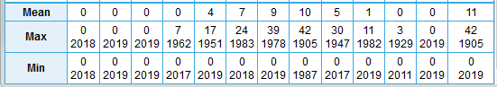
Here are the POR Max snowfall and Max Snow Depths (monthly and annually) for KAZO. One caveat is that they ceased to record snowfall at the airport circa mid-2000's. I've been around since then and believe nothing since then has likely surpassed the numbers.
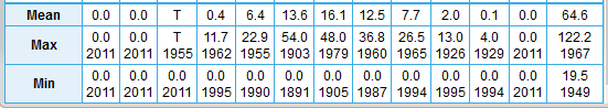
Good stuff, man. I found this tweet rather interesting as well:
In the last 20 years, accumulating snow >1 inch here has happened after December 15th only once back in 2012. Our average date would actually be tomorrow. Seems like we're due soon eh?
-
2
-
-
Maybe a little something early next week for snow belt areas in Michigan?
-
3
-
1
-
-
16 minutes ago, Tom said:
Welcome aboard! You got a couple members that live in Michigan on here and one guy by the name of @Jaster who lives in Kalazoo also! Our guy @WestMJim is from the Grand Rapids area and will always post stats and historical data. Finally, you have @Nikowho is just north of Detroit. There is another member north of Niko but I forgot his name. Anyhow, regarding your question about Winter headlines here is a link you can use:
I appreciate the warm welcomes! Thanks, will check this out. It's in my blood to refrain from getting too excited, but I'd be lying if I said I haven't caught myself wishing for some legit flakes soon. That dusting on the 1st was a nice lil treat.
-
1
-
-
Moved to Kalamazoo area pretty recently from the southeast. Always been a huge snow and weather fan, and I'm sure even the worst of the winters here will exceed what I've been used to (average snowfall per season around 5-8 inches lol, I see it is around 60 inches here). I have one observation and one question
1) the occasional gales that happen in the fall are fabulous. Makes me appreciate the ferocity of the great lakes that im sure are not known to many in the country
2) what consists of a winter storm warning in SW Michigan and how often do you get them in a season? Where I was, this was 3 inches+ (in 12 hours) and 4 inches+ (in 24 hours). Winter weather advisories were 1-3 inches. I've had many bare winters. These were the only winter weather definitions I've been accustomed to and I'm sure there are far more definitions that I'm unfamiliar with (blizzards, lake effect, etc) that I want to get familiar with haha
Apologies if I've posted this in the wrong thread
-
4
-
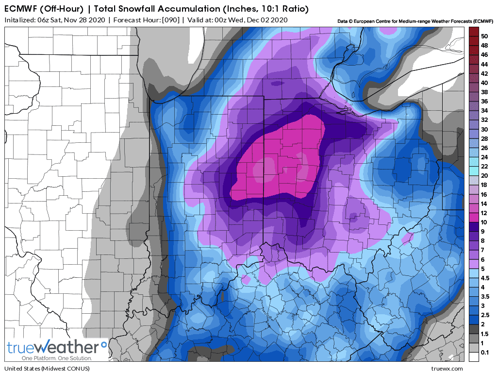


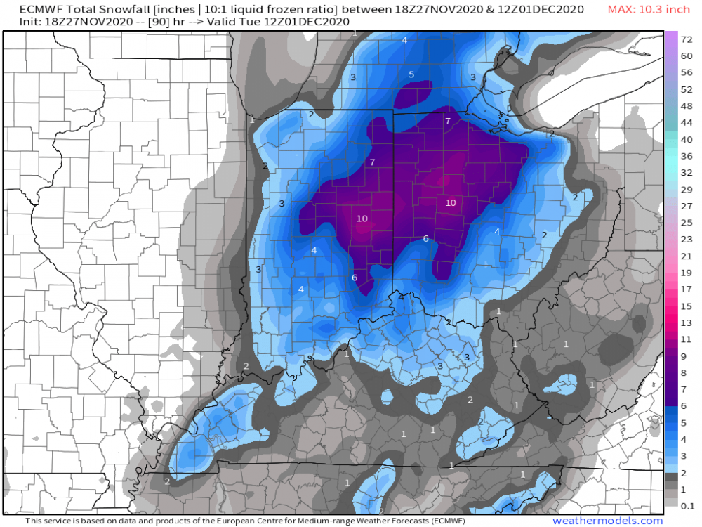
Nov 30-Dec 2 OHV/Eastern GL's possibly historic snowstorm.
in East of the Rockies
Posted
yessir it does. 7-8 3 inch plus events would be very welcomed. That's like 2 a month from december to march. Hope it pans out. I feel like bad luck sometimes don't want south busts to follow me haha