


Niko
-
Posts
12450 -
Joined
-
Last visited
-
Days Won
21
Recent Profile Visitors
3140 profile views


Niko's Achievements
")


-
Everyone be careful and wear eclipse glasses. Recommended glasses: ISO 12312-2.
-
So far it looks good for the eclipse here in S MI. Clouds should be outta here just in time, w/ partly cloudy skies. I decided to stay put, since 80 to 90% of totality serves me well. Enjoy!
-
Earthquake on the EC couple of days ago had me curious as to what could happen if the big one hits. Big cities need to have buildings to withhold, if a strong quake were to ever hit. Most of the current buildings and bridges were not build to take on strong tremors. Something to think about. NYC felt it. Nothing too terribly, thankfully.
-
Same here. Beautiful weather. Hopefully, tomorrow, the clouds will get outta here just in time in the afternoon for the eclipse. Great timing.
-
Looking forward to the "Eclipse" tomorrow. So many people traveling for this event. If that happens to be you, be prepared for lots and lots of delays. Best spot looks to be Upstate NY.
-
WOW! Hope everyone and yourself was ok w/ these crazy storms. The ones that are super scary are the nightime tornadoes when everyone is sleeping and not aware of bad weather coming. Stay safe there.
-
If anyone is interesting, I am selling my house in Greece (in Chios Island). I will put it on the market soon, but first I need to clean out the acres and inside as well. I am in the process of hiring someone from there to go and appraise it and also hire someone to have it freshen up and cut down some trees in the far distance and etc. Description: Has an amazing view of the Aegean sea and very close to Turkey. At nite, you can actually see the cars. No binoculars needed. An amazing view. Ton of acres. You have the ability to build another house there, or knock down the whole thing. Not sure of asking price yet, but an estimation will be for $250,000 Euro, so, in dollars will be roughly around $270,000, give or take. No negotiations! The house offers 2 floors: First floor, a kitchen, pantry, bathroom (w laundry), dining room, 2 bedrooms and 3 door outside entry. Doors lead you to the side of the house, to the backyard and lastly, the other door leads you towards the garage (1 car garage btw). Second floor: Master bedroom w huge balcony and a view facing Turkey and the Aegean sea and there are also steps going from the balcony to the roof, if you want to really get a tan, facing also extraordinary mountains. It has another bedroom down the hall and a library room (which that room can be anything you like. I decided back then to make it a library). Exiting the other bedroom, on the left, there is a door that leads to another huge balcony and steps to the right, leading you downstairs, near the garage. Its big house and lots of space to throw parties, entertain guests and etc. OK..back to spring weather!
-
Sorry for the late response amigo...been super busy. Me too, i missed a real severe t'stm. It feels like its been forever since I saw one.
-
I cannot wait for severe weather to start kicking in. Looking forward to loud thunder, along w dark ominous clouds, damaging winds and hail reports. It seems like it has been forever. Fav part is when a storm is approaching and you start seeing lightning and hearing thunder and feeling those winds cranking up.
-
Cloudy weather here today at the Big Apple w/ temps holding in the upper 40's. Some rain looking likely tomorrow w temps again barely getting outta the 40's. Was looking forward to some mild weather, but not looking likely. Hopefully, by the weekend, some 50s make a comeback along w some sunshine.
-
Beautiful weather here on the EC. NYC attm w/ lots of sunshine but chilly temps. Lows dipped in the 30s last nite but recovered only in the 40s these last 2 days. Will be in Times Square tanite dinner and possibly a show.
-
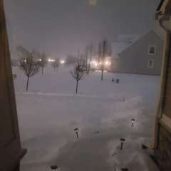
NOW until 12:00am Sat Winter Weather Advisory Today Heavy Snow High: 34 °F Tonight Snow Likely Low: 26 °F Well, isn't this special. A snowstorm for the Macomb area today. They are calling for 3-6inches, maybe more, if strong banding falls in. Part 2 is later this evening, w/ more snow. Temps are in the 20s attm. Honestly, I was hoping we were done w/ this mild winter. I would much rather had this back in February when not a flake fell...geez. Anyways, roads are not too good after listening to the news, numerous accidents out there. Looking out the window now, its snowing quite good and everything is covered, considering high sun angle. Good thing is that by early next week, this will all be a memory LOL...and back to spring.
-
After experiencing the 70s yesterday, I am definitely ready for spring. March right now is looking to have AN temps and I unless a fluke happens outta nowhere, my seasonal snowfall remains well BN, as expected. I am not surprised because in a nino yr, that is what you get. I am greatful that January snowfall was ironically AN. One thing is for sure, this winter was definitely a very mild one.
-
An incredible 72F here in SMI (Macomb area). Hard to believe it will snow tomorrow.
-
It is an incredible 68F right now and I am pretty confident that temps do get to at least 70F here in myby or maybe even higher than that. Just amazingly warm outside. I stepped outside and if feels like May. What a crazy winter weatherwise.


