


OKwx2k4
-
Posts
5472 -
Joined
-
Last visited
-
Days Won
33
Posts posted by OKwx2k4
-
-
1 hour ago, Clinton said:
Looks like we may see a bit of a phase 8 influence with the MJO for the second part of the month. So I would go with a blended look for temps.
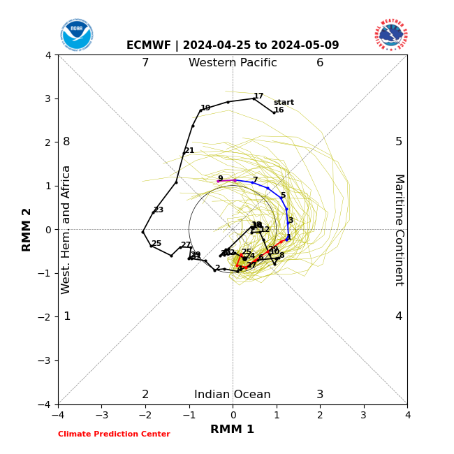
Still a pretty low amplitude phase as well. Would expect these to increase in amplitude as we go forward.
-
 1
1
-
-
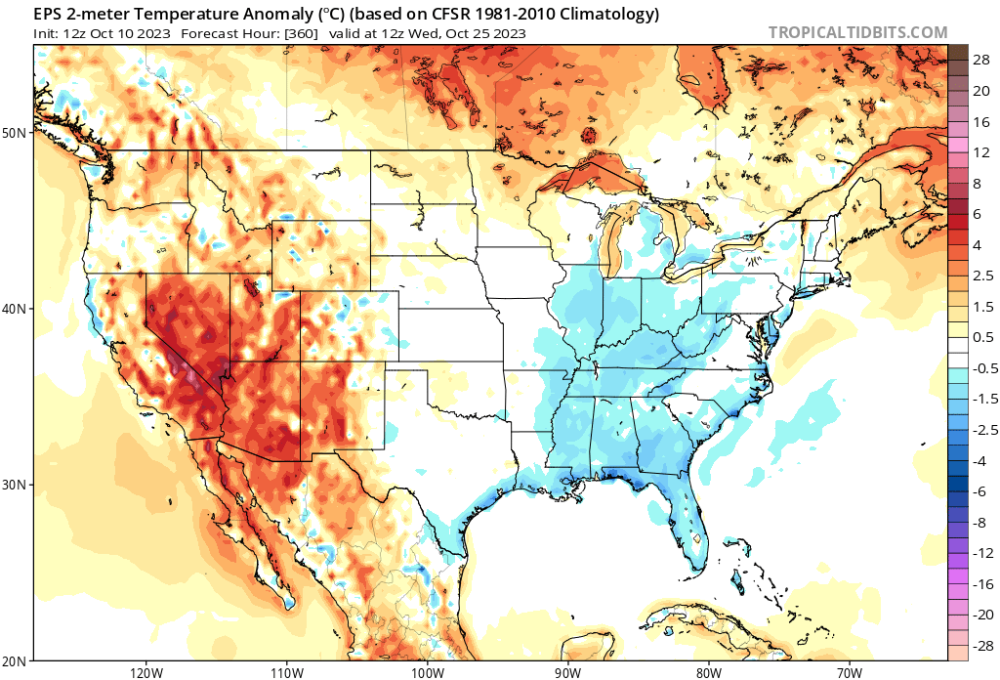
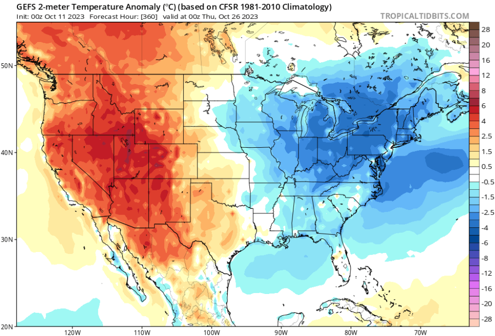
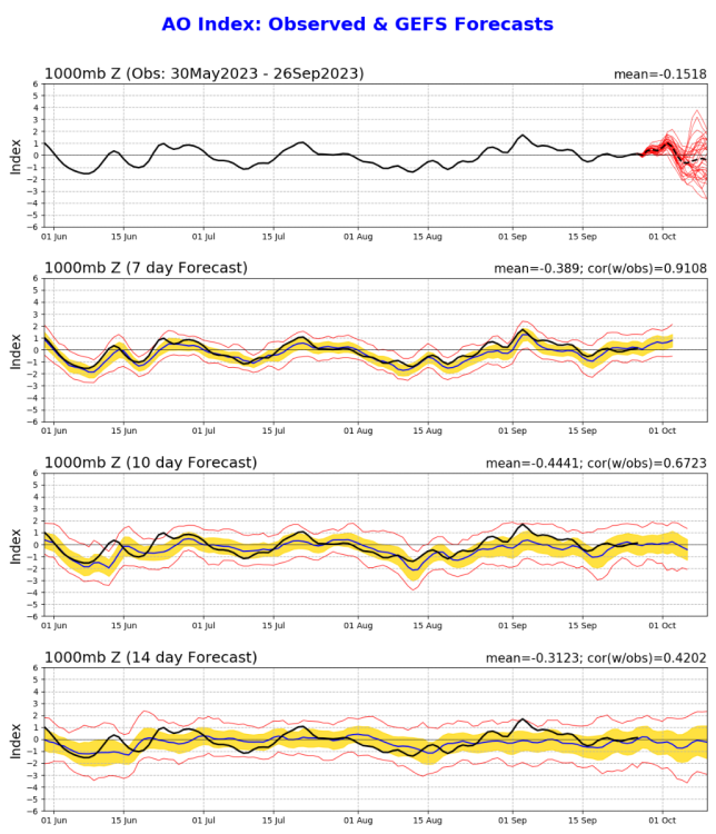
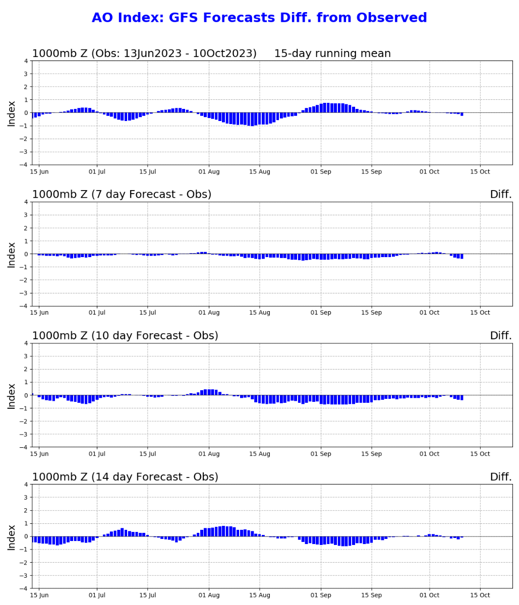
We have a split trend in the longer ranges as we go through the rest of the month.
The GFS is showing a strong rebound in temperatures across most of the country to close out the month.
The Euro ensembles are trending towards another long-term cold shot or cold pooling up right over the central states.
While I've complimented the GFS on its accuracy at longer ranges lately, will be interested to see if it fails miserably due to the double-dip feature in the AO pattern.
(It's ensembles do go to a similar pattern as Euro.)
@Black Holemade a great point about the shallow nature of the airmasses.
The source regions for cold are running highly above avg in temperature right now, which makes it really all the more incredible to see a three day cool blast in October.
-
1
-
 1
1
-
-
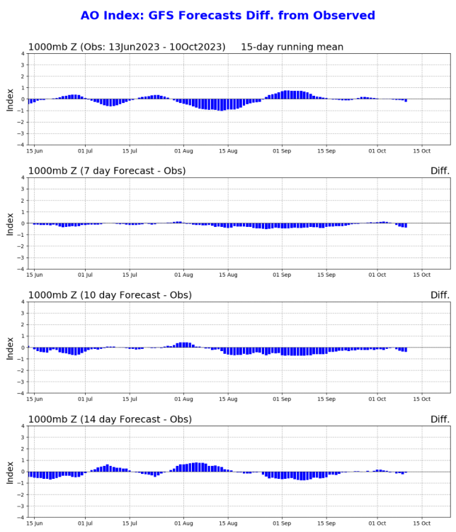
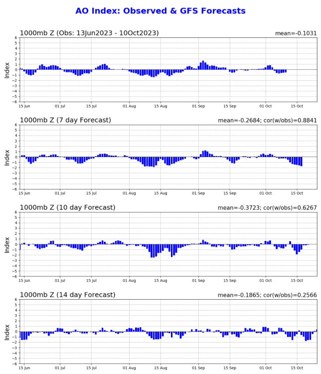
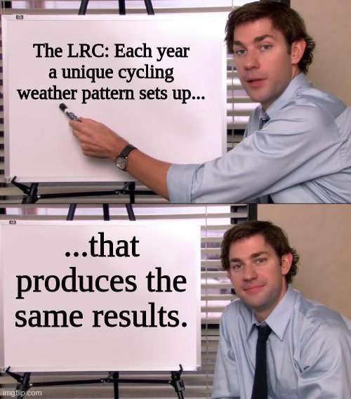
Should have went in an earlier post about the GFS and AO, but these explain it well.
Not perfect, but none of the models are. When the AO dumped in August after dipping and sending a ridge-busting cooldown in July, it was a sort of tell I was talking about. It's a unique weather pattern.
-
1
-
-
Another thing I want to come in to make a note of, the GFS has handled cold air masses at range better since September 10th or so than any other model.
It's still hedged to the warm side vs verification, but I am pretty impressed with it.
The AO is continuing the pattern it started back in July, in my opinion. Looking ahead, once the tropics go through more seasonal retrogression, cold will get on the way again.
Sometimes that rogue AO crash in July is a tell. This year its proving its worth.
-
2
-
-
4 hours ago, Andie said:
I’m hearing talk of severe weather in No Tx Wednesday or Thursday.
Is that fact or fiction?I've not seen anything to agree with this. There is a cold front and winds supposed to move through the area, but no forecasts of storms at this time.
-
1
-
-
15 hours ago, Black Hole said:
The near surface airmass will be at least as cold. It looks pretty dry, but also it looks to hold on for a few days instead of immediately reverting to southerly flow. So yeah, we should really get a nice stretch of cooler days here.
Looking ahead, we're headed for a setup that produces phasing storms if we don't end up with an overpowering polar jet or STJ.
I love what I'm seeing ahead.
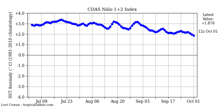
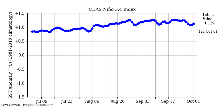
ENSO is trying its last surge in 1.2 but I'm pretty sure it won't reach where it was back in July. This means there will probably be another warm-ish spell as Oct closes and November opens, but it'll be awesome after.
-
1
-
-
18 hours ago, Black Hole said:
I think it's a testament to how not-cold it's been lol.
Going from a close of September at near record highs to the first frosts here only a week away from our record first is really crazy.
This cold shot the 14th looks to rival a lot I have seen in October as well.
Definitely arrived with a crash. I love it.
-
5
-
-
1 hour ago, Black Hole said:

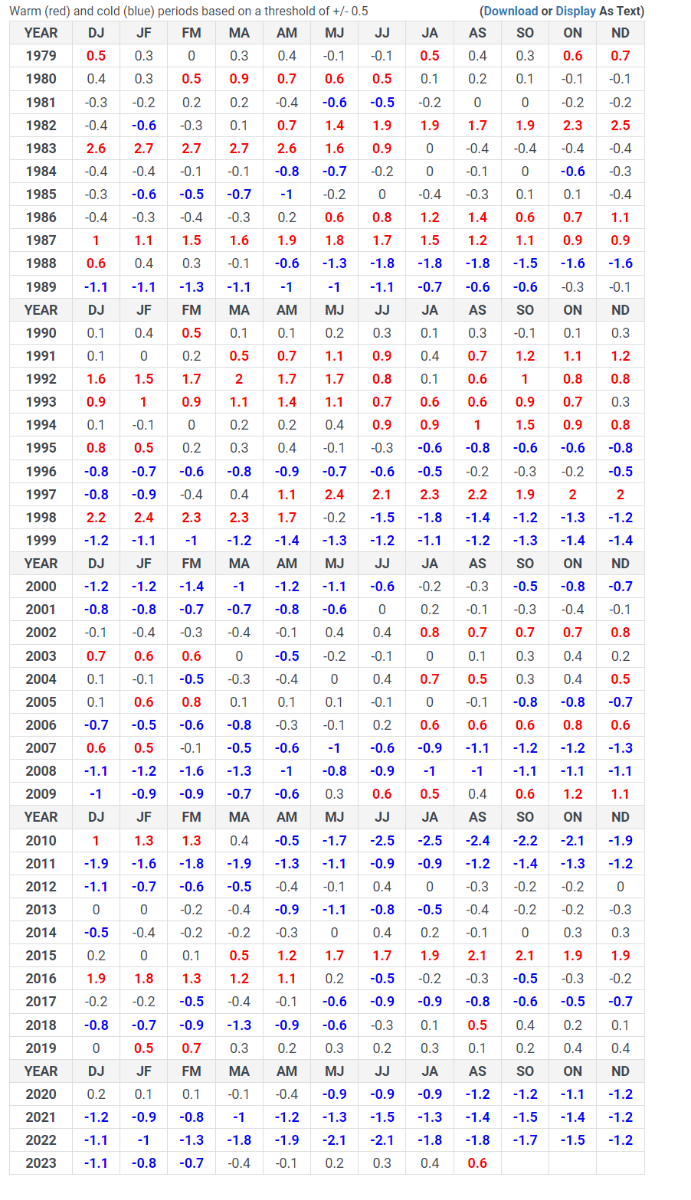
Here is the MEI table since 1979. Our AS value finally reached weak el nino status. This year is nothing like 15/16, 97/98 or 82/83 at this point (other "strong" ninos). Its actually a pretty good match to 09/10 or 02/03 by this metric.
Yes. When I was writing earlier in the year in another post this was what I was referring to and I couldn't think to call it the right term. Lol.
This is why I've been telling folks there was so much more to this than met the eye and a spot check of temperatures is not really how you measure things. You use the same standard that was always used. You don't change it to make news about nothing. It's a coupled system and you have to use and observe it all the same.
It's also becoming known that major enso + episodes work against the mjo in 8/1 during the peak of winter. 8/1 are cold phases over N. America.
It's growing apparent by that chart as well that we are actually entering a long-term cool phase if we look at the 80s-90s vs 2000s to today.
The chart starts right after the PAC climate shift ended in 1979.
-
3
-
-
21 hours ago, Black Hole said:
Thanks! From what I understand the cooler stratosphere from the extra warming promotes a stronger PV, which will be at odds with the negative QBO and tendency for a SSW. Solar maximum also usually supports less blocking. I've also heard that the current pattern in the NE Pacific often proceeds +AO years so there are definitely some cross currents we will have to deal with but I remain optimistic as a whole.
Correct on very many points.
I'm still optimistic as well, but we've both correctly identified the things which could go wrong or cause a warm-wet winter.
The El Nino being forecast to shift westward and decline is a big plus, along with what appears to be a consolidating N. Pac warm pool SE of the Aleutians.
-
1
-
-
Welcome to fall 2023!
-
2
-
 1
1
-
 1
1
-
-
12 hours ago, Black Hole said:
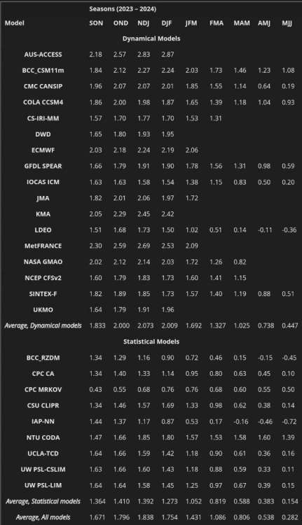
To be clear, I am not arguing with you, it's all intended to be positive discussion. But if you look at their past predictions for el nino, they all look exactly like this with minor variations. Same thing for la nina. There is no apparent attempt to use what we know to make adjustments such as for Modoki el nino verses classical, +/- QBO or IOD, or snow cover in Oct in Siberia...etc. Lots of known seasonal predictors but every year its just smearing all the like ENSO events together. But, oh well lol
It's refreshing to see someone working there say what I've been trying to say for years. I agree with you. I get why they do it, but there's got to be room in there for other proven predictors. They all need their proper weight for it to work better.
I think the work you've done in analogs is pretty awesome there's a lot of thought invested.
With the QBO, -AO forecast, I'd tend to weight the cooler years more, but those are offset against a few unknowns too. A giant volcanic eruption and this likely being the first true -QBO since the absent qbo cycle a few years ago. Another anomaly is the above average Atlantic hurricane season. Solar maximum plays a role as well.
There's more to be done or taken into account for seasonal forecasting by real weather and doing it better is what we are saying.
I like the 60s analogs you used and the 2009 year as well.
-
2
-
-
1 hour ago, Andie said:
At 11 it’s 69 and light rain. More rain west of us. This has been nice and much needed
81 tomorrow with a light breeze. Nice change.
I'm so glad the seasons have finally officially flipped for you and that your drought is ending.
-
1
-
-
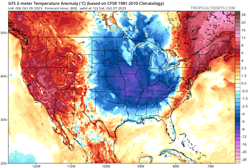
This is really a pretty shocking late-forecast increase in potency of the first real cool shot of the season. Gonna have a little bite in it.

-
2
-
-
If ENSO is poised for a surge, it is doing a poor job of displaying it.
If anything, looks to stabilize or decline.
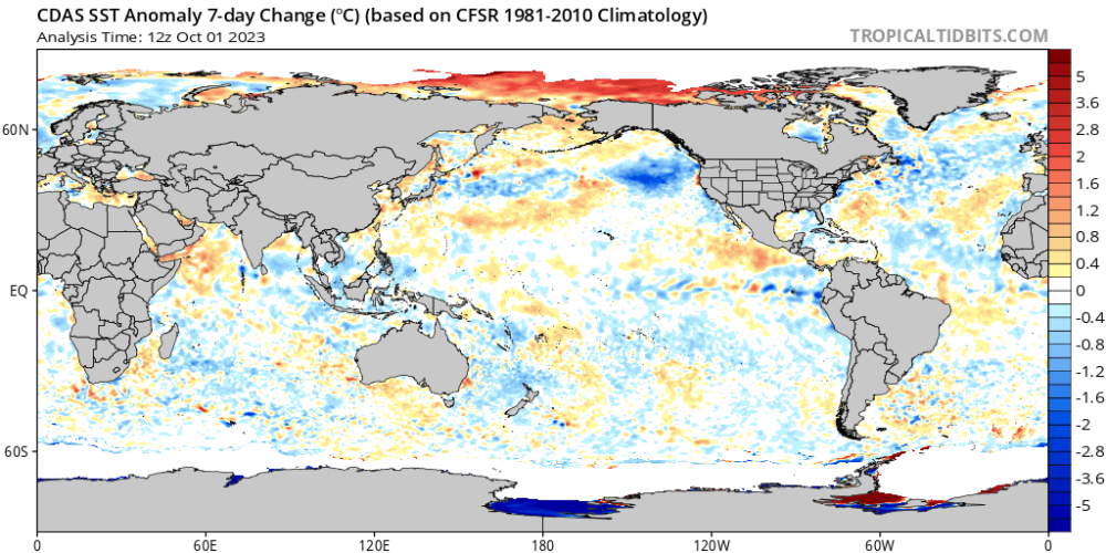
Not really a fan of the cooling in the GOA/NW coast of US. Would like to see that sudden reverse to warming. Would give hope for these ridging episodes to finally go away for a good while.
-
3
-
-
At 86/62 and 4.87 inches of rain, (today's data won't change much) September was very warm and humid as the DP averaged 60.
The closing days' highs, at or above 85 degrees since the 23rd, have really boosted an already warm opening week to start things off.
-
Of note, we have hit some of the highest -PDO values ever this year....in an El Niño. How wild is that?
-
3
-
-
Ahead on GFS, if the 3 frontal passages in 10 days works out, that'll pretty much be as real as autumn can get for a lot of us.
If that's our new pattern, wait til December and January.
-
3
-
-
On 9/26/2023 at 9:55 PM, gabel23 said:
Well you crazy weather fanatics it's time to start the biggest month of the year!! (If you follow the LRC at least) . Been seeing a lot of winter forecasts being released and it sounds like at the very minimum will have a weak/moderate El Nino(hoping not a strong!). The things I'll be watching is the NAO and AO. if we can keep those neutral or negative that would do wonders. Analog years I have seen that have matched up with the long range forecasters, or at least the ones I follow, leads to a fast start to winter. October and November cold and possibly snowy for the upper midwest?? 02-03 and 09-10 are winters that I remember; 09-10 by far being one of the best in my memory (NAO and AO negative pretty much the whole winter). 57-58, 72-73, 77-78 was also fast starts to winters, at least around my area. Let the discussions and new cycle begin!
https://www.facebook.com/JimFlowersForecaster/videos/294496906601118
Well, there's my late 70s and 09-10 analog comments confirmed in a good way.
Would be wild to see 6 weeks straight of snow-covered ground or winter from Thanksgiving to spring break.
-
3
-
-
11 hours ago, Tom said:
Has anyone on here been to Hot Springs, AR? @OKwx2k4its kinda by your area and was wondering if you had ever visited this place. Looks really nice and naturesque.
Believe it or not, I have never actually been there, but I do know the picturesque part to be truth. This whole area and northeast of me is really beautiful. A lot of the Ozarks are. I don't think you'd be disappointed.
-
2
-
1
-
-
14 hours ago, mlgamer said:
You do not often respond to my posts so to be clear I believe the LRC is pretty much what Lezak claims it to be. At the time I was noting that though a "unique" whether pattern sets up each year we had had very similar winters over recent years. Overall I think there are other longer term patterns that the LRC works within that explains why we have below normal snowfall for years on end for example. Like I said, Gary understood my point and laughed about it.
I was saying the same thing, basically. I know a lot of folks who don't believe in it or discredit it but believe in unfounded things.
-
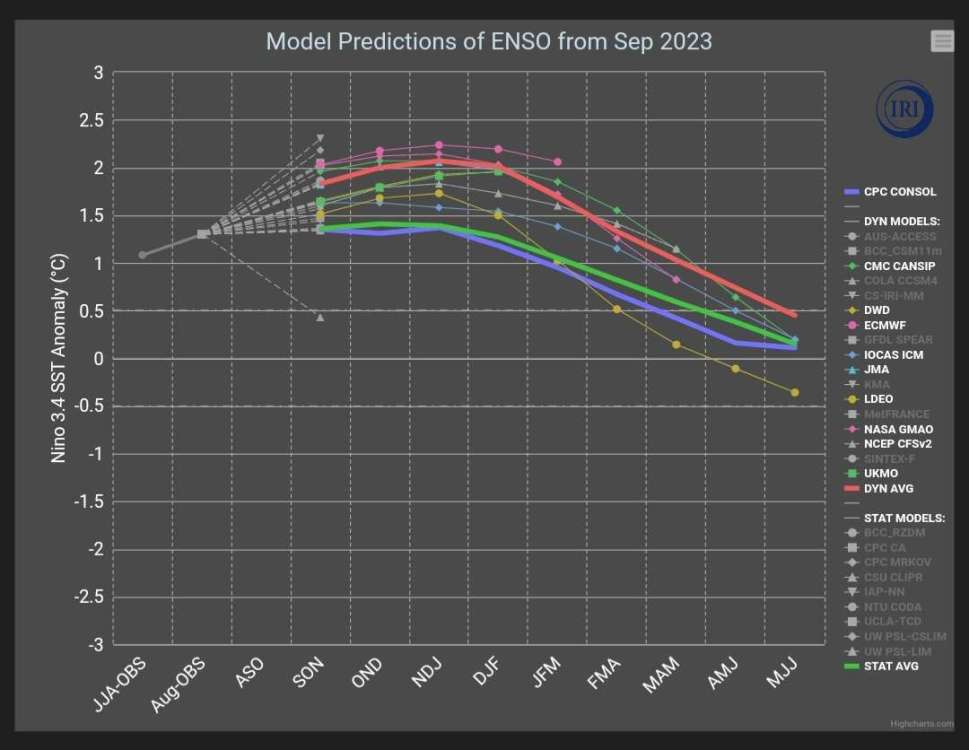
Here's the numerical spread on Niño predictions for each model. There are some that are way stupidly too high. This would explain the forecast avg that I believe is too high. A lot of the models start at too high of a number to begin with.
I removed some of the models so the averages could be better seen. (2nd Image)
-
1
-
1
-
-
22 hours ago, mlgamer said:
With a new LRC setting up soon, I once joked with Gary Lezak on the old KSHB weather blog about this and he laughed and pretty much agreed. All in fun.
Lezak's theory holds more provable merit than many of the other weather/climate-related theories have over the same span. Its still not perfect, but I have to give dues where they are due.
-
4
-
-
I saw recently from something that was posted last weekend by Joe Bastardi that we are, even in grip of Niño, at only +0.23C globally in terms of temperature anomalies. Nowhere close to a record.
#FailNiño
-
1
-
-
On 9/17/2023 at 7:21 PM, jaster220 said:
Couldn't this "double peak" tho? Pretty sure I remember one where that's exactly how the winter became a dumpster fire in the Midwest. Was it 15-16 perhaps? Was looking promising, then it just re-surged at the last minute. Idk, maybe I'm loosing my memory.
I believe 15-16 was a super-Nino suckfest all the way from October up, but I was deceived by the water temp alignments off Mexico and the US west coast. They overrode some of Niño effects, but not all.
-
1
-


October 2023 Observations and Discussion
in East of the Rockies
Posted
Models now trending to leaving me cooler than avg all but 48 hours or so of the entire run. That's definitely noteworthy.