OKwx2k4
-
Posts
5500 -
Joined
-
Last visited
-
Days Won
33
Recent Profile Visitors
2353 profile views


OKwx2k4's Achievements
")


-
Being from the edge of the purple OK/AR/KS/MO area I can attest to this being true. It's usually noticed more here because of the trees as well as compared to somewhere further west in the flatter grasslands/plains.
-
Definitely a plus to have rain but not at the cost of thrashing the crops. It's a wonder of how many different hits they can take.
-
Going to feel like a true festivus in July miracle.


-
@westMJim I find it amazing that what is regarded widely as the coldest February ever nationwide fell in what is still regarded as the hottest year in US history, 1936. The extremes that we see sometimes just in a state, also are very amazing. The balances we see over small spans.
-
Well, after hurricane Beryl's passing here and points east, our weather actually looks to rise to above normal temperatures and then, per euro ens may well see July close with falling temperatures vs the average. Will be really interesting to see how the month closes out over the eastern US. Also have begun watching the seasonal changes over the northern Pacific. If I'm reading the SST profiles well, they also back me up on a cooling trend over the eastern and central US. An area I'm going to watch very closely will be the waters around the Aleutian islands. Reminds me of autumn out today actually. Beautiful weather for July.
-
An unbelievable number of tornado warnings right now on the Northeast side of Beryl. Wow... Don't need a massive hurricane when you have seven tornadoes or more.

-
I'm sorry to hear about the crop losses. I know that's a hard thing to deal with in itself then adding in the countless property losses its just tough. You said the rest very well. It goes around you sometimes for years, until it doesn't.
-
It looks to me like Hastings is about to be hit by tornado. I pray not.
-
Was coming back on to say there's some bad stuff going on up there near or north of Hastings. Holy moly. Looks like an unwarned tornado honestly.
-
I know a lot of folks will be very happy to see the rainfall associated with the tropics and also our frontal boundary heading down the plains.

-
Right. Any lingering coolness would likely be as much precip related as "cold pool" related. I think a lot of folks are looking for a break at any rate. May well get it.
-
I'm jealous. In a few years, I'm going to start going every summer if I can this time of year and playing the WSOP. A local guy and acquaintance from my area is a professional poker dealer. He just dealt Phil Ivey a piece of history the other day on live television. Pretty neat stuff. Wish I was there buddy.
-
This is not good at all. However, my hurricane season forecast is starting right where I'd have drawn it up. Interesting. I didn't think our first tropical punch would be at Florida first. Eastern Fla and the Mid-Atlantic coast to the north are my other targets later in the season.

-
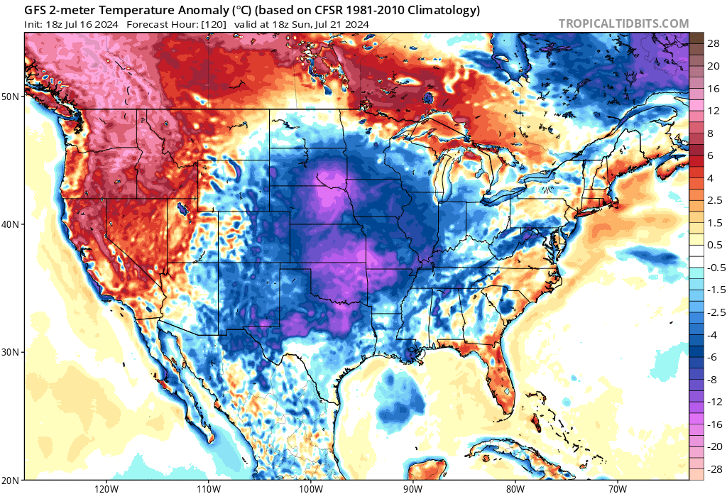
What is disheartening about this image the most is the fact that western OK and KS are going to go right into the 110 degree drought I'm afraid of. A big stagnant death gyre is going to setup. Yuk.
-
Getting the idea at least something is going to kick out of the tropics this year. If this were to verify, it would confirm parts of my forecast already. If Lezak is right, and a hurricane strikes the hardest part of Florida to hit, then my forecast already needs a trip to the drawing board. Lol. That's the most improbable place in my opinion to have a hurricane. That or maybe the GA coast. They haven't recorded a hurricane strike since 1899.