
OttumwaSnomow
-
Posts
575 -
Joined
-
Last visited
Everything posted by OttumwaSnomow
-
Pretty much tells the story here today. Although it fell to 68 this am. 97.3 temp, 81 dewpoint and I even saw for a moment 120 "feels like"!!!! Was brutal.

-
How does that work? Ive heard this before, that even though a high or low occurs it isnt counted as the "high or low" for that day because it was momentary? Anyone know where I can find more info?
-
My Highs today most at about 2:20 pm 95.0 temp 81.1 dewpoint 114.1 heat index
-
That reminds me of 2010 here. Crazy amounts of rain here, 60 to 75 inches! We were getting mowers stuck daily. Couldn't keep up with 50 lawns. Now for years it seems like a different planet! Almost never too wet to mow, no standing water. Grass growing a slow rates. Now we mow over 200! One is 60 acres.
-
I havent seen a 100f temp for 5 straight summers here! In 2012 it was 100f nearly 30 times! Btw was 56f here this am.
-
Kaj is one of the best in Iowa!
-
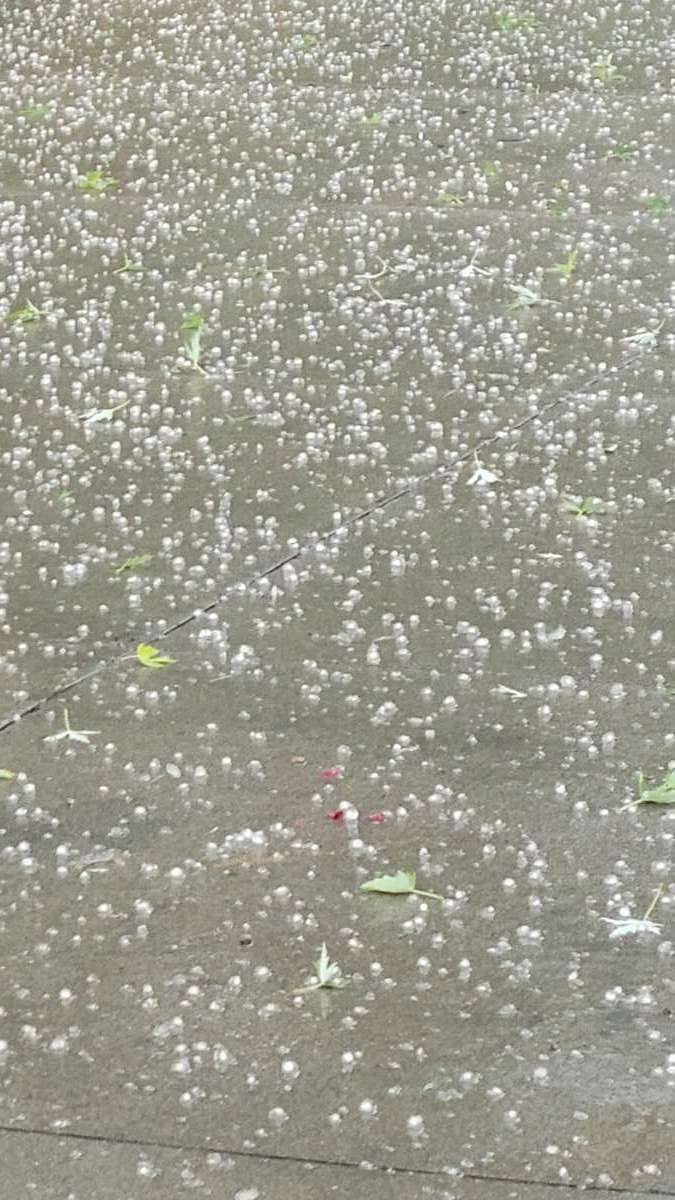
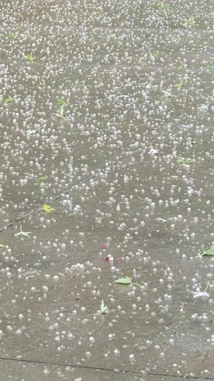
Wow! Totally unexpected and unpredicted series of training cells this am! Only about half inch so far. But has hailed on 2 different occasions. Yesterday i drove to Iowa falls and gotta say my specific spot as green as anyone! Crops and lawns right at my spot incredible! Love those sagging fronts draped near mo ia border ! Where as a passin front moving east usually nada! 20230717_094305.mp4
-
Its very odd to me (being from east originally) how cold fronts can pass thru on very hot humid days at peak heating and be a total dud!! Front was over me at 4 pm. Barely a cloud. It literally does this 90% of fronts here. But same fronts blow up near or east of miss river. Ive learned that a west to east moving cold front is pretty much useless in se iowa in summer. It needs to be west to east oriented sagging or wiggling near ia mo border. Most of my rain comes in 4 to 8 am timeframe. Decaying mcs. But in colder months precip hangs back behind cold fronts. I have my theories as to why these differences exist in iowa as opposed to further east.
-
Wow! Glad for you guys! I only got .40, nothing severe at all. The one front runner popup basically went indianola to albia and died just giving me .10. But the ball keeps rolling, no heavy rain at all but has rained on about 15 days since june 1.
-
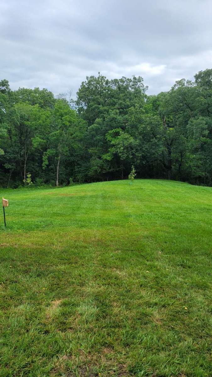
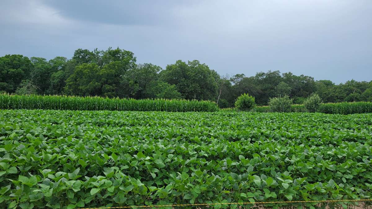
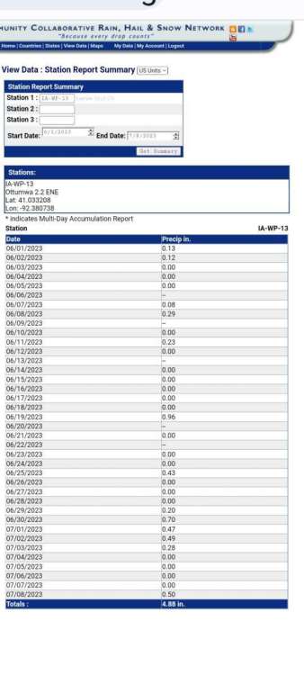
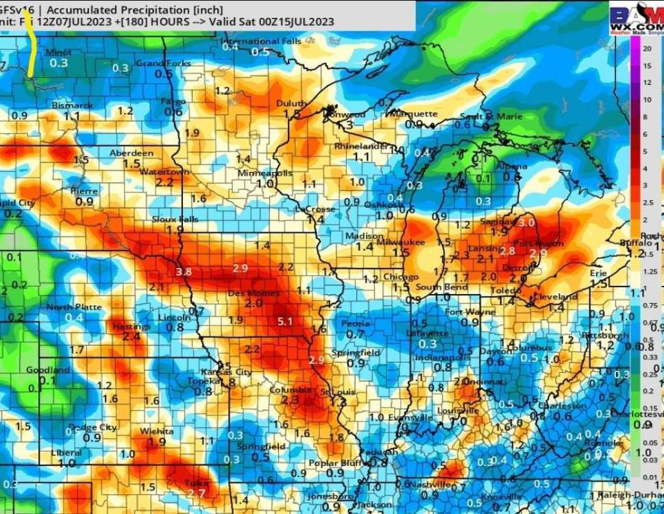
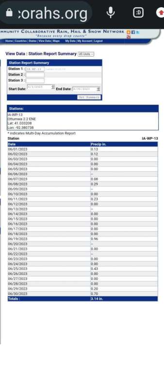
I got a .50 surprise rain yesterday. I must say the drought monitor for wapello county now is simply not accurate now. Since June 1st Ive recorded 4.88". Since June 19th Ive recorded 4.03". You could say the past 3 weeks are actually above normal rainfall, coupled with the cool temperatures the droughts affects are chsnging. Here are some pics. And if gfs is accurate we seem to keep the ball rolling next 10 days!


-

June 2023 Observations & Discussions
OttumwaSnomow replied to westMJim's topic in East of the Rockies
Not yet. Its been so low i haven't wanted to take any water from it. But we have a sweet corn area right beside the pond so in coming years we might. Another .43 overnight!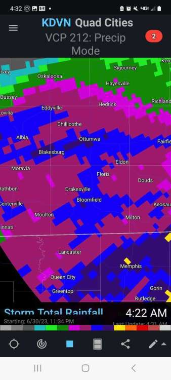
-
June 2023 Observations & Discussions
OttumwaSnomow replied to westMJim's topic in East of the Rockies
Im getting much better. But still probably a horrible 8 or 9 inches behind in the April to June timeframe. Lawns responding nice to past 10 days of rain. But absolutely zero runoff so my pond keeps dropping. With exception of a couple weeks almost no runoff going back to December 2021. But in the 2017 drought i went 18 months with JUST ONE 1 INCH PLUS RAIN, that was west of Ottumwa! -
June 2023 Observations & Discussions
OttumwaSnomow replied to westMJim's topic in East of the Rockies
Wow! Finishing out June strong! Despite being dead in the driest part of Iowa. I have 3.67" in June! .53 today.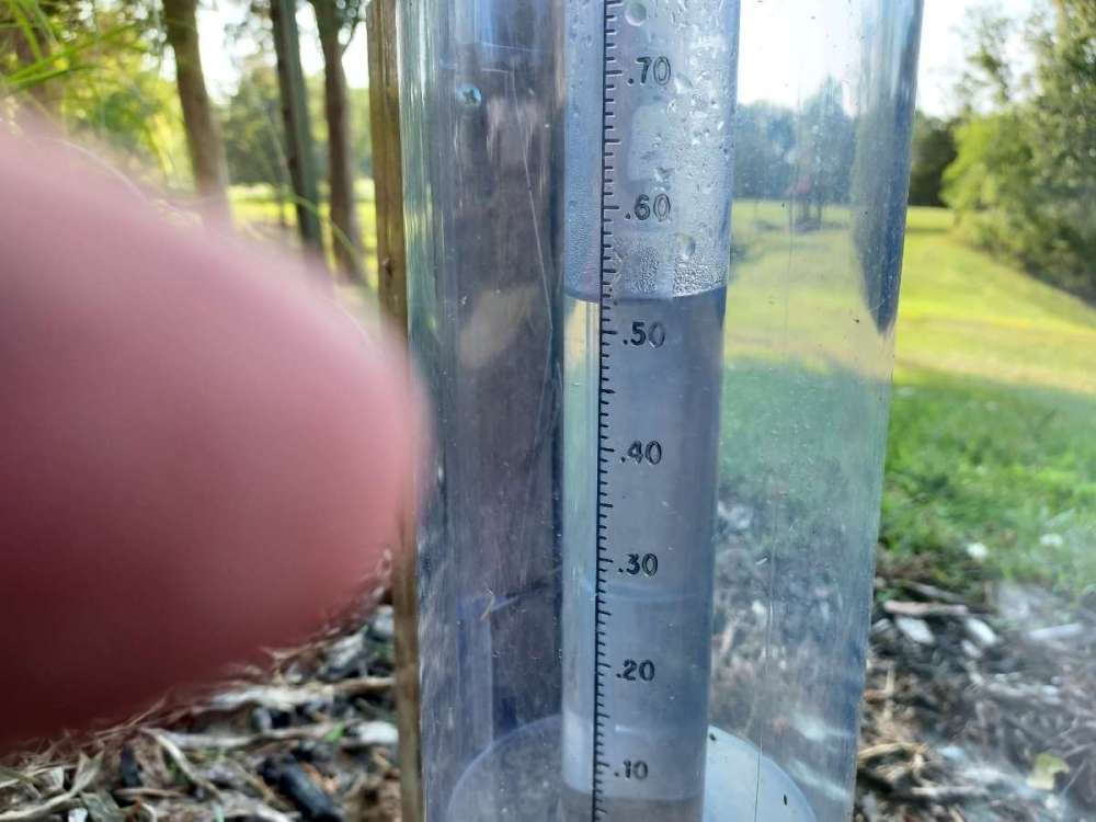
-
June 2023 Observations & Discussions
OttumwaSnomow replied to westMJim's topic in East of the Rockies
Just incredible.. im approaching 4.5 inches in june!! Has rained on 11 different days! Most has fallen past 11 days. But many areas near within 20 miles of me haven't been as fortunate. -
June 2023 Observations & Discussions
OttumwaSnomow replied to westMJim's topic in East of the Rockies
Ive heard more thunder and saw more lightning past 24 hrs than the past 14 months. Not kidding -
June 2023 Observations & Discussions
OttumwaSnomow replied to westMJim's topic in East of the Rockies
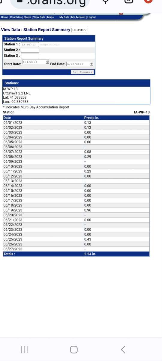
I have 2.24" in june and has rained on 7 days. Miles ahead of mays .89"! Better than most in my area here in SE Iowa.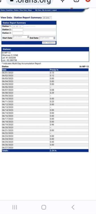
-
June 2023 Observations & Discussions
OttumwaSnomow replied to westMJim's topic in East of the Rockies
Trust me the south needs it bad!! Especially along hwy 2. Bloomfield has 1 inch since april 22!!!!! No place drier in Iowa! Except maybe near council bluffs. -
June 2023 Observations & Discussions
OttumwaSnomow replied to westMJim's topic in East of the Rockies
.43 at my home and farm today. I had a friend check my cocarahs gage. I have been extremely fortunate to catch some on about every thunderstorm anywhere nearby during june. I think im at 2.10 in June. But its the .89 in May that hurt. -
June 2023 Observations & Discussions
OttumwaSnomow replied to westMJim's topic in East of the Rockies
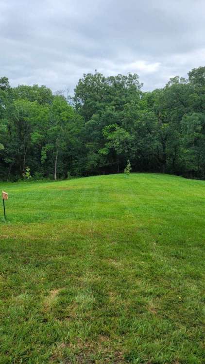
Im not at home. But wow! Every time i spew off about my areas deficits (which still exist) we get hammered! A friend northside says .38 and this pic is from southside.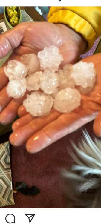
-
June 2023 Observations & Discussions
OttumwaSnomow replied to westMJim's topic in East of the Rockies
I expect next to nothing. Today and probably until at some point in September. Maybe a freak popup on occasion when we have a 10 to 30% chance. Simply put thats the Ottumwa Bloomfield Fairfield tendency. No offense but since 2012 the Ottumwa Bloomfield Kirksville Fairfield area is clearly the "hell hole of the midwest"! By aug 2022 we had a 15 inch deficit for the year. Currently for 2023 we are near 10 inch deficit! No doubt by aug 15 to sept we will be near a 17 or 18 inch deficit! -
June 2023 Observations & Discussions
OttumwaSnomow replied to westMJim's topic in East of the Rockies
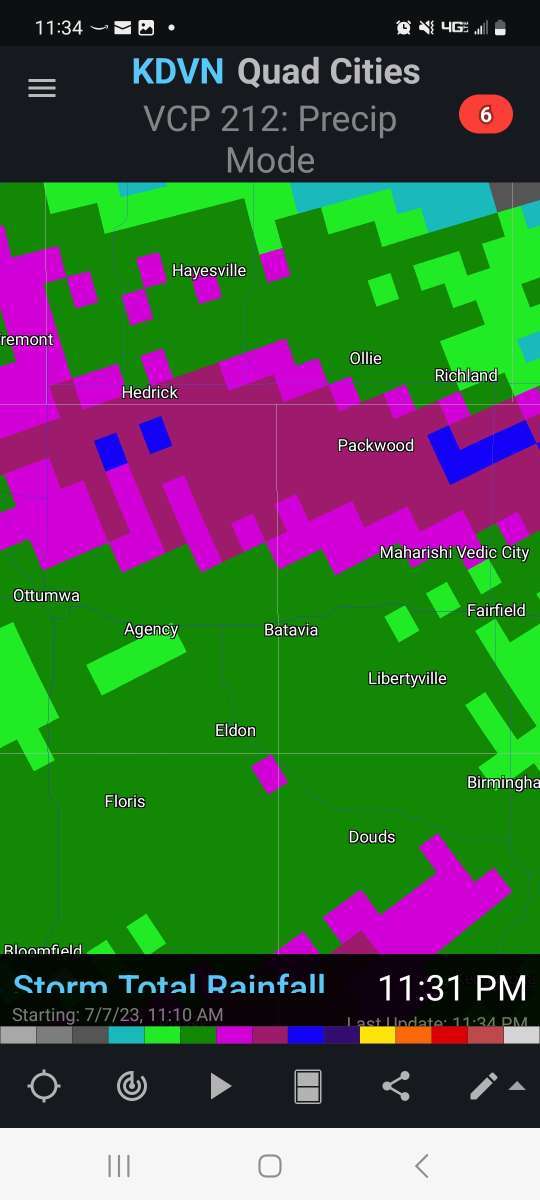
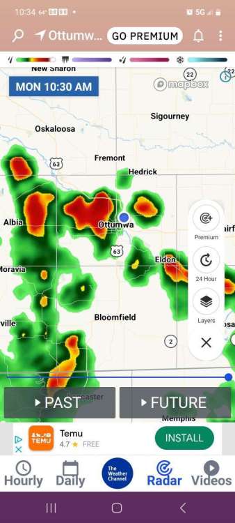
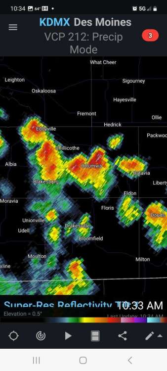
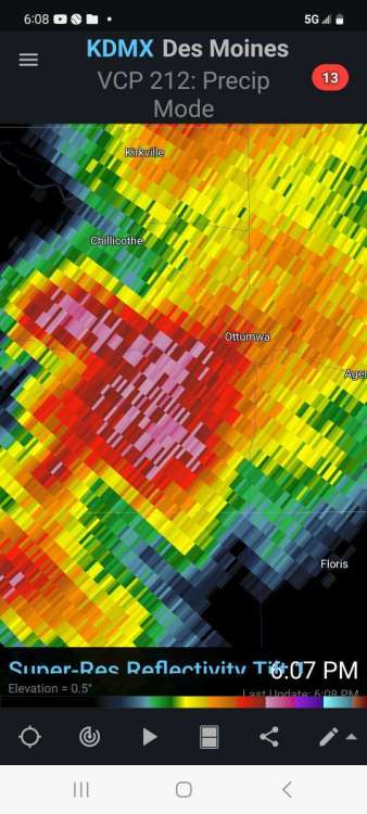
Yet another se Iowa sucker punch. Its impossible to think but its possible some spots near me dont get much over 1 inch the entire spring and summer! I've come to realize that east moving fronts and lines of storms are totally useless in my area. We need some kind of miracle sagging east to west front near the mo/ia border just to get a decent widespread rain for years now. My last 3 good summer rains over past 2 yrs were weird popups moving west! Freak stuff from the east. KDMX - Super-Res Reflectivity Tilt 1, 12_44 PM.mp4 -
June 2023 Observations & Discussions
OttumwaSnomow replied to westMJim's topic in East of the Rockies
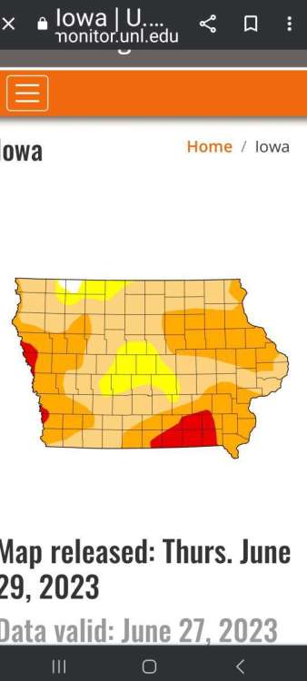
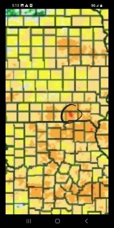
Hate to preach to the choir. But check out these departure from normal rainfal maps. Davis county Iowa up to near Ottumwa theres a small area which IS THE DRIEST IN THE USA! Except for the nw coast. This situation was almost identical to 2017. The area nnw of drakesville barely has one inch in those 60 days. Keep in mind this area is the wettest in iowa year round averaging nearly 10 inches in may and june combined.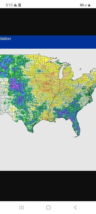
-
June 2023 Observations & Discussions
OttumwaSnomow replied to westMJim's topic in East of the Rockies
Ive always kept decent records. But have moved quite a bit over the years. I think I emailed them declaring my availability now that i live so near the city and ive always known of the need in my area for coop observers. The nws sent me a couple emails so we have a appointment forthcoming. I live and work on my property almost 24/7/365 now. Will involve both temperatures and precip i believe. -
June 2023 Observations & Discussions
OttumwaSnomow replied to westMJim's topic in East of the Rockies
Yes I am the only cocorahs in wapello county. I have some big news coming soon Im getting very close to becoming the official location for the nws (coop observer)- Ottumwa station nws reps should be coming to my property soon to scope out where to put the equipment. The location is much better than the OTM airport since its 7 miles from downtown. Im just off the ene edge of city and less than 2 miles from the long time location on the Des River. Ive noticed the data for our area to be sorely lacking with the automated equip, like melting winter precip etc. My son can help me out since he is a weather hobbyists as well. If not a employee can do it for me. -
June 2023 Observations & Discussions
OttumwaSnomow replied to westMJim's topic in East of the Rockies
This is a thing of beauty! Yesterdays mid day thunderstorm! VID-20230619-WA0000.mp4