

Joshua Lake Oswego
-
Posts
1005 -
Joined
-
Last visited
-
Days Won
1
Posts posted by Joshua Lake Oswego
-
-
6 minutes ago, SilverFallsAndrew said:
First freeze for SLE. 27 at HIO, 28 at CVO and EUG.
PDX all the way down to 36.
-
 1
1
-
 3
3
-
 1
1
-
-
-
Stuck at 44 here. Bottomed out at 38 this morning. 47 for a high.
-
 1
1
-
1
-
 1
1
-
-
8 hours ago, Joshua Lake Oswego said:
This thing is going to bust so hard for Portland and areas south today. We might get .10''.
Ok, I was at least partially wrong. I admit it. Portland did well. South of Portland… not so much.
-
6
-
-
This thing is going to bust so hard for Portland and areas south today. We might get .10''.
-
 2
2
-
-
The N/S QPF gradient this winter is going to put 2020 to shame. Just brutal.
-
2
-
1
-
-
6 minutes ago, Phishy Wx said:
Could we get an AR and an Arctic blast to align this winter? preferably in late Dec to minimize sun angle.
Please and thanks
Like what happened in Leavenworth last January? I missed that by one week.
-
3
-
-
4 minutes ago, Terreboner said:
Lots of new members joining today. Count me in as well!!!
Hilarious username
-
2
-
-
00z GFS is whetttt!
-
6
-
 2
2
-
-
14 minutes ago, Front Ranger said:
I don't think it's even a lock for PDX (definitely not for most stations). The next 10 days are going to be MUCH cooler than the monthly average to this point.
You might be right. If we average 56/44 over the next 11 days, we will beat the record by .1 degrees. I think we’re going to break the record, but it’s certainly not a given like you said.
-
4
-
-
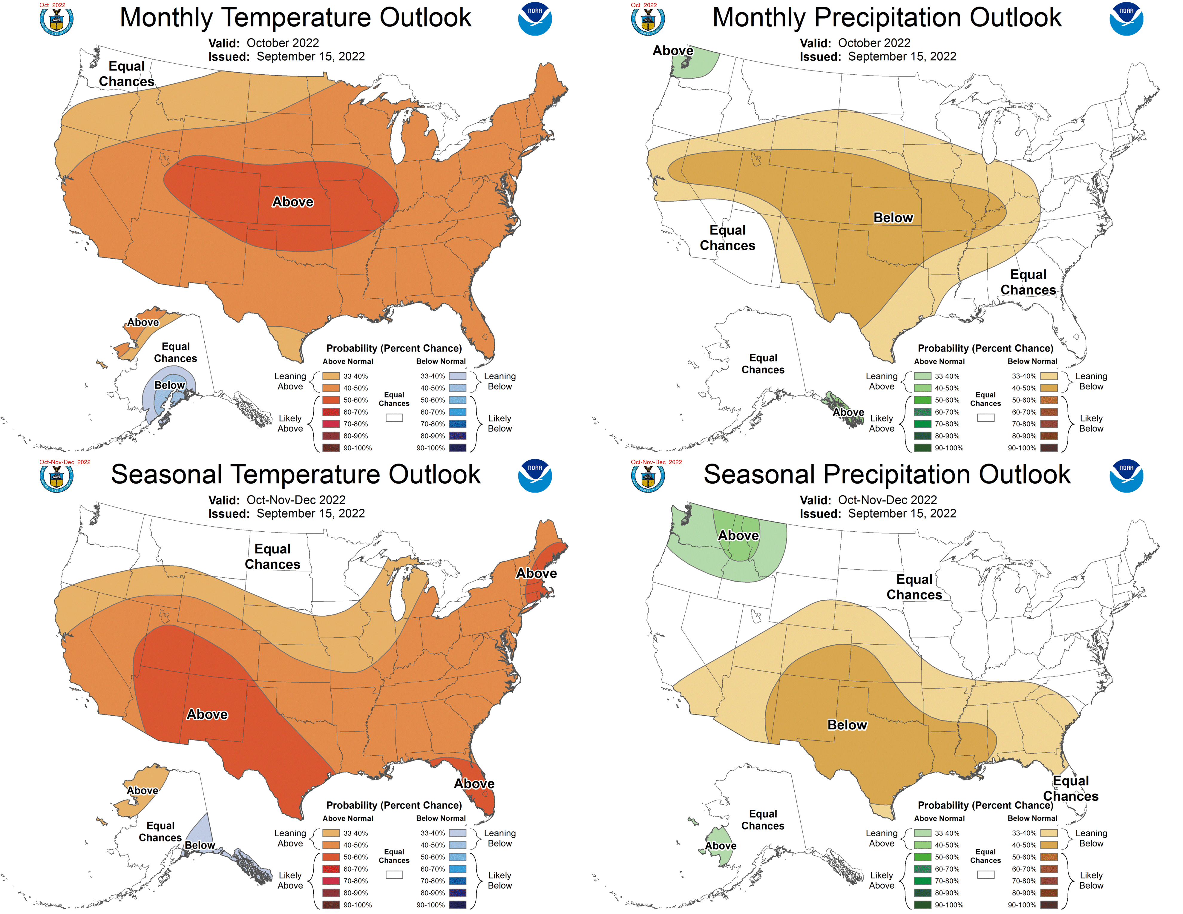
First 20 days of October summary at PDX:
All 20 days warmer than normal
0.00’’ precipitation
65.8 average temperature
>8 degrees above normal
1 day <5 degrees above normal
1 high temp below 70
3 low temps below 50
Highest temp = 88
Lowest temp = 48
12 days above 80
The warmest October ever is a lock. That’s after the warmest week ever in July, the warmest month ever in August, and the warmest September ever. The most anomalously warm month ever is still possible.
Now that the RRR is behind us, let’s cheers to bountiful lowland rain and mountain snow, cool temps, and some exciting model riding. We have earned this drink.
-
5
-
1
-
-
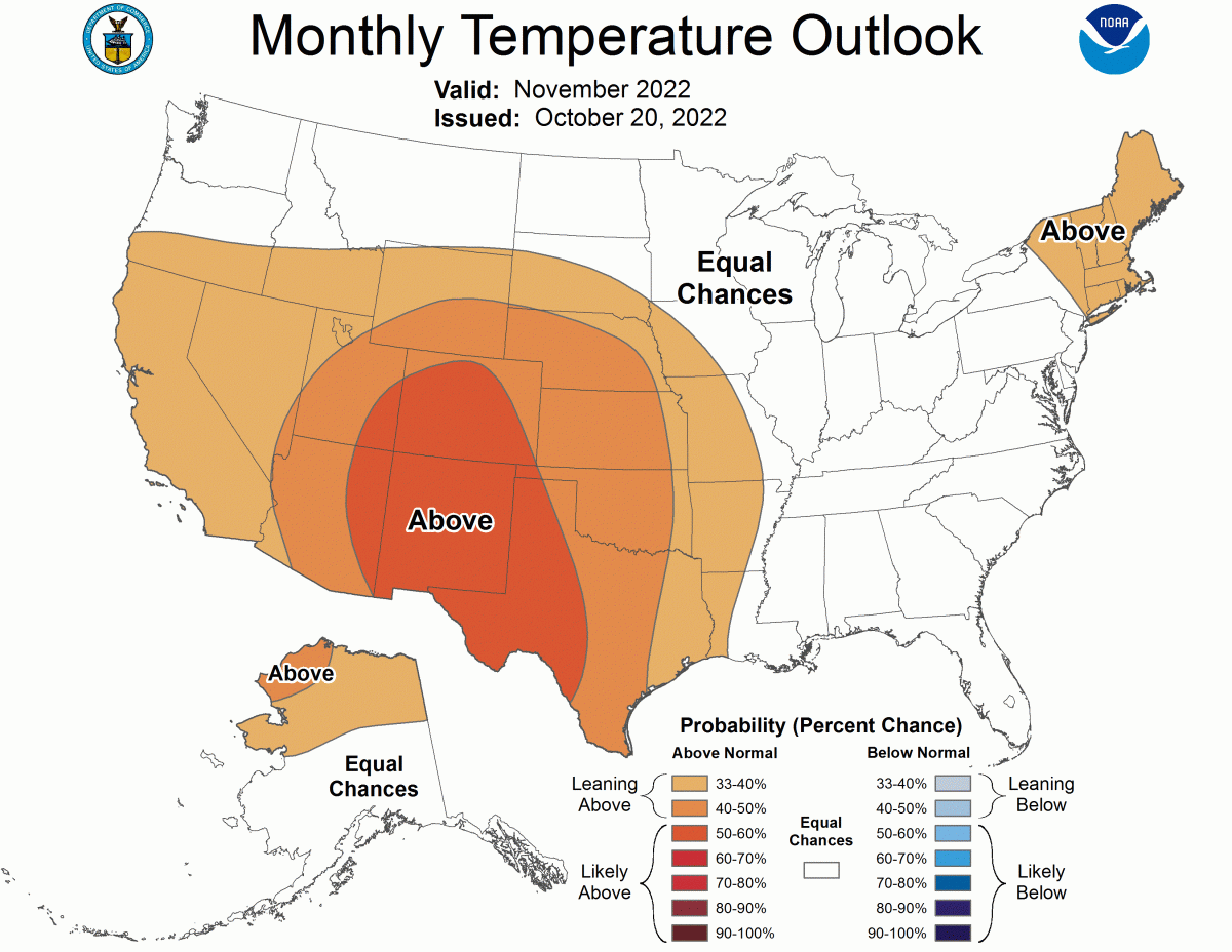
2 minutes ago, Sonny Summers said:
That's not the updated one. They do an update at the end of the month.

Well yea, but that's cheating. We knew at that time that the first couple of weeks of October were going to absolutely torch. The point is that the one issued today is close to the time of the month they initially issued the October forecast and we can see how that tuned out.
The bigger point is... don't put a lot of stock in monthly or seasonal forecasts.
-
1
-
-
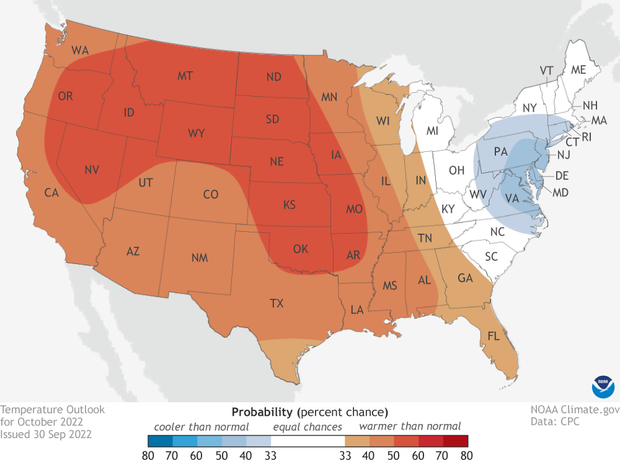
27 minutes ago, Sonny Summers said:
The November outlook is hot off the presses. Keep in mind the outlook will be updated at the end of this month.

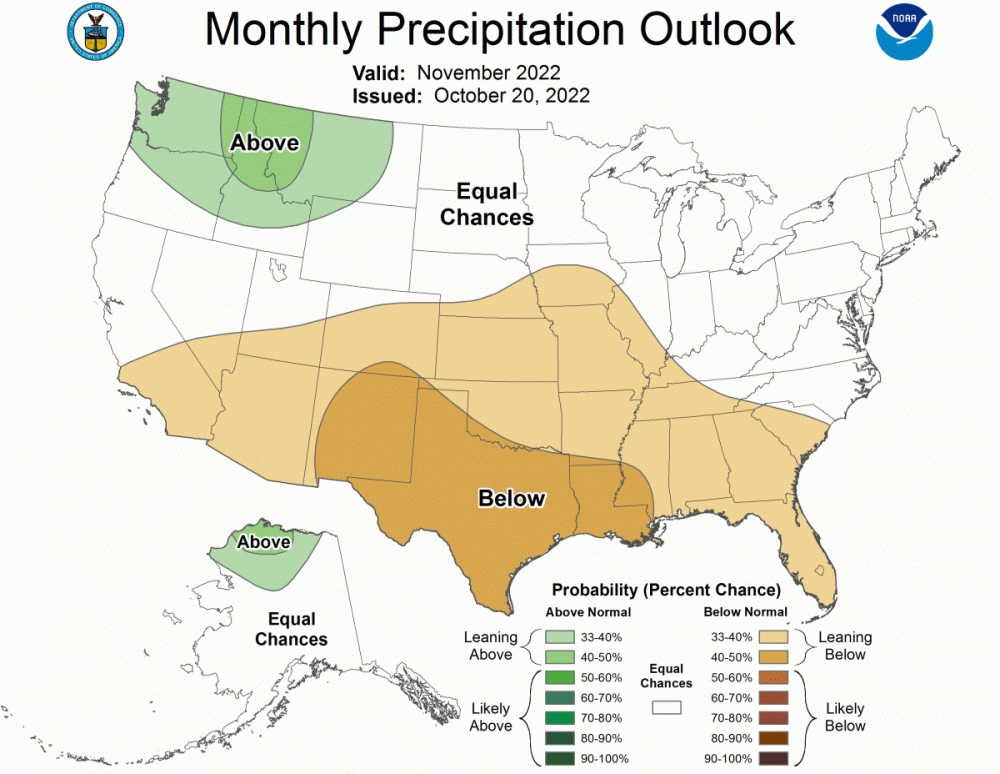
Is that the same CPC that issued this comically incorrect October forecast last month?
-
9 minutes ago, RentonHillTC said:
Euros got some drip
GEFS has got some drip.

-
7
-
1
-
-
5 minutes ago, RentonHillTC said:
Euro!!! P-O-R-T-LAND, JETS JETS JETS!
Who could have seen that coming???
-
1
-
-
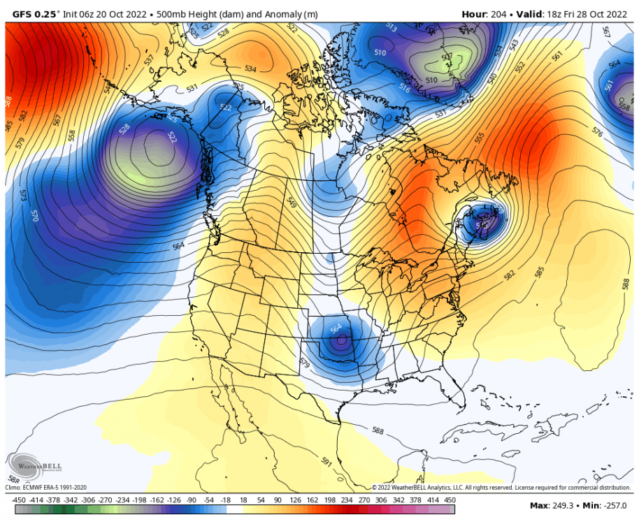
The good news is that the CFS has us under the influence of a massive ridge for a couple of weeks in the middle of November. You know what that means... trough city baby.

-
2
-
1
-
-
GEFS looking much better than the GFS so far. No ridge in sight.
-
4
-
1
-
-
The 12z suite is not great so far. In one run, the GEM went from...

to:

Then there's the GFS...

-
1
-
 1
1
-
 1
1
-
2
-
-
59 minutes ago, Omegaraptor said:
The NAM is usually a more accurate picture of valley floor QPF than the lower res major models are.

It's mesoscale model time at this point.
-
1
-
-
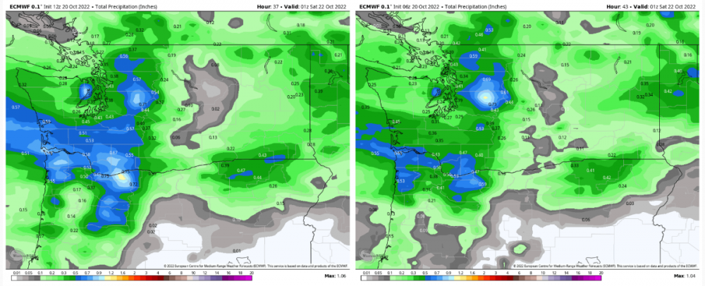
I have a feeling this thing Friday evening through Saturday is going to bust pretty hard from Portland south. Maybe .10'' - .20'' before the rain tapers to showers late Friday night. Scattered downpours on Saturday. Meanwhile, Longview to Seattle will do well. Portland is right on the edge and could catch the southern edge of the steady precip.
-
 1
1
-
2
-
-
1 hour ago, TigerWoodsLibido said:

No worries…

-
2
-
1
-
1
-
1
-
-
6 hours ago, Skagit Weather said:
It takes forever to get there though. The next week is still relatively dry in Washington (of course still way wetter than anything we've seen so far).
Exactly. It always gets pushed out. Friday night once looked really wet for all. So did Sunday night. Now, it’s the middle of next week. It eventually will be, but we need it yesterday. Actually, we need it six weeks ago.
-
There are going to be some losers with the first shot of rain. It is not looking like a widespread soaking unfortunately. I think the losers will be south of Portland and BC. Longview to Bellingham will be the winners. The Cascades will do very well of course.
The good news is that there are more decent chances for a widespread soaking in the pipeline. Of course, we are getting close to the wettest month of the year where we average about .20’’/day. So, soon any 10 day forecast with <2’’ is actually below normal.
-
1
-
-
The QPF king (ICON) shows some nasty rain shadowing for the first two ‘’events’’ (Friday into Saturday and Sunday into Monday). The Cascades are going to get slammed. Most of Washington should do pretty well. Portland south will likely not get very much. The Euro always overdoes QPF.
-
1
-


November 2022 PNW weather Discussion. #NoRidgeNovember
in West of the Rockies
Posted
Why is it so hard for us to avoid persistent ridging? Outside of the most recent couple of weeks, we have been ridging consistently since mid-June.
For the people that think it is gloomy and rainy endlessly for 9 months here, I would love to know what 9 months those are.