


chescowxman
-
Posts
580 -
Joined
-
Last visited
Everything posted by chescowxman
-
The front has moved through the area and temps today will be about 15 degrees cooler than yesterday with highs near normal in the upper 60's. We turn colder than normal for the weekend with high temps struggling to escape the mid 50's for higher spots and upper 50's in lower locales. It will be cloudy with some showers possible most likely on Sunday into Sunday night. We warm back up again by the middle of next week before we cool back down for the week of the 12th with a stretch of below normal readings. Chester County records for today: High 95 degrees at Phoenixville (2018) / Low 28 Devault 1W (1957) / Rain 3.00" Devault 1W (1985)
-
We are off to a 1.6 degree cooler start to 2024 (42.6 degrees) compared to last year across the Chester County PA reporting sites. However while cooler than last year we are at the 9th warmest first 4 months on record since 1893. The Top 8 warmest are 1998 - 44.24 2023 - 44.22 1990 - 44.0 2012 - 43.7 1913 - 43.1 2017 - 43.1 1949 - 42.8 2002 - 42.8
-
High here in East Nantmeal was 84.8 - no Airport or MADIS locales here in Chester County PA have hit 90 today. Highest obs was the 87.8 at KOQN airport in West Chester 90's are certainly much tougher to find out here in the Western philly burbs
-
Here in Chester County PA we finished April with an overall average temperature of 53.8 about 2.0 degrees above the long term 132 year average. The warmest spot was as is usually the case Phoenixville as the lowest observation spot in the county at 54.9 degrees. The coolest was the 53.0 in Warwick Township. Overall this was our 28th warmest April on record across 132 years of observation data. Of note 13 of the top 20 warmest Aprils occurred prior to 1990. While 3 of the coldest Aprils have all occurred just since 2007. Below is a graph analyzing the April temp trends (actual in blue) since 1893. I have also as always overlaid the NCEI adjusted temps (in red). As we can see they again consistently applied chilling adjustments to cool the data for every year over 110 consecutive years from 1895 thru 2005. Of interest since 2005 they have now begun to apply warming adjustments to the actual data in 12 of the last 18 years. The appropriate trend lines reflect the clear impact these post hoc adjustments have made to the warming trend lines.
-
After yesterday's slight cooling today will see temps pop back up into the 80's. We should see temps trend back to normal and then below starting tomorrow through the weekend. Some higher spots in the county may actually struggle to escape the 50's for high temps both Saturday and Sunday. We will also see some showers around by Sunday. We should warm back to above normal by the middle of next week but should see a solid stretch of cooler than normal temps returning by mid-May. Chester County records for today: High 91 degrees at Coatesville (1899) / Low 28 degrees also at Coatesville (1903) / Rain 1.84" at Chadds Ford (1976)
-

April 2024 Observations and Discussion
chescowxman replied to westMJim's topic in East of the Rockies
We have a chance to hit 80 degrees here in East Nantmeal for the first time since last September 9th. If not today for sure tomorrow. Mostly sunny both today and tomorrow before shower chances increase by Tuesday PM. Slightly cooler but still above normal temps will close out the work week. Chester County Records for today: High 92 degrees in Phoenixville (1915) / Low 26 degrees at Coatesville (1946) / Rain 2.00" at Devault (1952) -
April 2024 Observations and Discussion
chescowxman replied to westMJim's topic in East of the Rockies
Today will make it 8 of the last 10 days featuring below normal temperatures. That ends tomorrow as temps soar into the high 70's and then 80's on both Monday and Tuesday! A slight shot at some showers today but a better chance on Tuesday. Temps should remain above normal in the mid 70's for much of the upcoming week. Chester County Records for today: High 95 degrees at Sadsburyville (1915) / Low 26 degrees at Coatesville (1926) / Rain 2.45" at East Nantmeal (2007) -
April 2024 Observations and Discussion
chescowxman replied to westMJim's topic in East of the Rockies
Below is an analysis of the average temperature by decade here in Chester County for the months March - April and May since the 1890's. The average temperature over these 132 years of records is 51.5 degrees. So far in the 2020's we are running about 0.5 degrees above the average. The 1940's were not surprisingly the warmest decade. -
April 2024 Observations and Discussion
chescowxman replied to westMJim's topic in East of the Rockies
Near normal temps today before colder again through Saturday. We may see frost or freezes again by Friday morning. Big warm up on the way by Monday with temps possibly reaching the 80's for the first time in some areas. Chester County records for today: High 91 degrees in West Chester (1960) / Low 26 degrees at Coatesville (1930) / Rain 2.40" in Coatesville (1968) -
April 2024 Observations and Discussion
chescowxman replied to westMJim's topic in East of the Rockies
It was actually slightly warmer last night with more spots remaining above freezing than Monday AM. The lowest reading I could find was the 29.9 in Warwick Township. Here in East Nantmeal we only made it down to 35.7...I also did not note any frost. While many lower spots have had several days below freezing here in April in EN we have not been below freezing in almost a month (March 25th) Today we should reach the mid 60's for highs. A slight chance of showers tonight and tomorrow with cooler temps again to close out the work week before a nice warming trend kicks in starting Sunday. Chester County records for today: High 91 degrees (1960) / Low 24 at Coatesville (1922) / Rain 2.38" at West Chester (2012) / Snow 2.0" Sadsburyville (1911) -
April 2024 Observations and Discussion
chescowxman replied to westMJim's topic in East of the Rockies
Some lower elevation locations like Chester Springs (30.2) / Nottingham (27. and Warwick (29.1) fell below freezing while the relatively highers spots like East Nantmeal (34.3) and KMQS Airport (35.6) remained above freezing. The NWS has issued a frost advisory for tomorrow AM with the same lower elevation spots likely to see frost and or freezing temps. Tomorrow should be the only day this week that we see near normal high temperatures. Before a cold front crosses the area by Wednesday morning setting the stage for more frosty readings on both Thursday and Friday mornings. Chester County records for today: High 92 degrees Phoenixville (1985) / Low 22 degrees in Coatesville (1922) / Rain 2.44" West Chester (1927) / Snow 1.1" in West Chester (1895)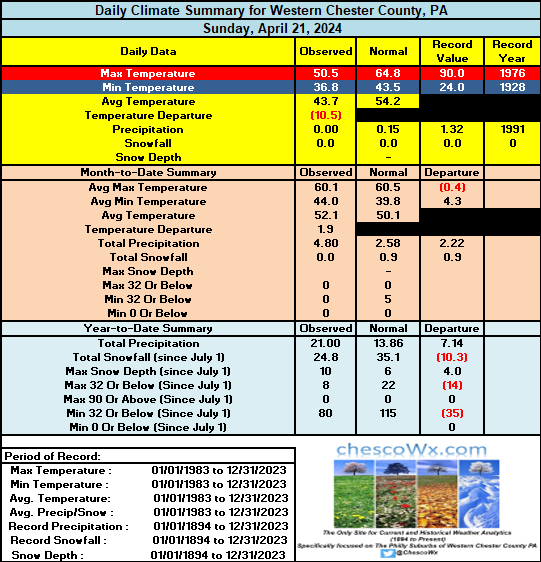
-
April 2024 Observations and Discussion
chescowxman replied to westMJim's topic in East of the Rockies
Mid to upper 30's across most of the county this AM. Today should be an unseasonably chilly late April day with temps likely not escaping the 40's in the higher spots of Chester County this afternoon. I suspect we will see some frost across lower elevations in the county tonight with dew points already well below freezing at this time and clearing skies overnight. Great weather for both Monday and Tuesday before shower chances on Wednesday. Another shot at some frost or even a freeze by Thursday AM again especially in elevations below 500 ft in the county. Chester County wide records for today: High 90 degrees in both Coatesville and Phoenixville (1976) / Record Low 24 degrees at Coatesville (1928) / Rain 2.11" at Longwood Gardens (2012). Of note today is the earliest day without any measurable snow. The latest measurable snow here in Chester County PA was recorded in Glenmoore on May 2, 1963. -
April 2024 Observations and Discussion
chescowxman replied to westMJim's topic in East of the Rockies
After some light rain overnight we are starting to see some sunshine across the area. It will be a few degrees below normal today with highs only in the low 60s. Sunshine the next few days with well below normal temps both tomorrow and Monday before we warm to near normal by Tuesday. Next shower chances arrive on Tuesday night. Chester County wide records for today: High 91 at West Grove (1941) / Low 23 in Coatesville (1926) / Rain 1.99" in Phoenixville (1940) / Snow 5.0" West Chester (1983) -
April 2024 Observations and Discussion
chescowxman replied to westMJim's topic in East of the Rockies
After yesterday's chilly day today will be another day with high temps running near 7 degrees below normal with readings in the upper 50's. We get back to near normal temps tomorrow before dropping back to the mid 50's on Sunday. We should see normal to below temps for much of the next 10 days or so. Some shower chances tonight and again by Tuesday night into Wednesday. Chester County records for today: High 93 degrees in West Chester (1976) / Low 24 degrees at Coatesville (1904) / Rain 2.05" Coatesville (1943) / Snow 5.5" in Coatesville (1983) -
April 2024 Observations and Discussion
chescowxman replied to westMJim's topic in East of the Rockies
Another sunny day but much cooler than yesterday across the area with temps mainly in the 60's to near 70 (still almost 7 degrees above normal for today). Rain chances ramp up by tomorrow PM and will last till Thursday AM. Another chance of showers on Friday night before we slip back to below normal temperatures for the upcoming weekend. Chester County records for today: High 90 degrees Phoenixville (2002) / Low 20 degrees in Coatesville (1926) / Rain 5.45" Chadds Ford (1983) / Snow 2.5" at Coatesville (1923) -
April 2024 Observations and Discussion
chescowxman replied to westMJim's topic in East of the Rockies
Some great weather over the next few days although with the winds today might be a bit tough on some allergy sufferers. Looks like shower chances return by Wednesday and could last through the rest of the week! Our wet year continues! Chester County Records for today: High 91 degrees Phoenixville (1941) / Low 21 degrees West Chester (1940) / Rain 2.28" Coatesville (1970) / Snow 2.5" Coatesville (1923) -
April 2024 Observations and Discussion
chescowxman replied to westMJim's topic in East of the Rockies
0.24" of rain so far since yesterday here in East Nantmeal. Might see another 0.25" or more if any thunderstorms pop up. Shower chances finally go away by Saturday PM and after a chilly Saturday we should see a nice warming trend get underway by Sunday and carry us into next week. Chester County records for today: High 90 degrees Devault (1977) / Low 18 degrees Phoenixville (1921) / Rain 2.29" Kennett Square (1913) / Snow 3.0" Devault (1959)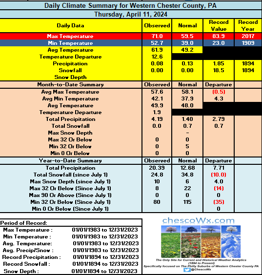
-
April 2024 Observations and Discussion
chescowxman replied to westMJim's topic in East of the Rockies
Clouds and showers to close out the work week with the heaviest rain likely overnight tonight. Sun returns and cooler on Saturday before a nice warm up with temps into the mid 70's for the county next week. Longer term a return to below normal temps looks increasingly likely as we move into next weekend and toward the end of the month. County records for today: High 89 West Chester (2013) / Low 20 Phoenixville (1921) / Rain 2.06" West Grove (1929) / Snow 18.5" Coatesville (1894) -
April 2024 Observations and Discussion
chescowxman replied to westMJim's topic in East of the Rockies
Mild again today but we look cloudy with increasing shower chances for the rest of the work week before we clear out for the weekend. Some models paint another 1" to 2" of rain by late Friday. Chester County records for today: High 88.9 at Nottingham (2013) / Low 15 Devault (1958) / Rain 2.05: Coatesville (1993) / Snow 9.7" (1894). Of note this snow was the start of a 2 day snowstorm that was the largest snowstorm in April history with 29" of snow falling at Coatesville.. The NWS PHL historical weather page details this April storm as follows.1894...(April 10-12) Md-DC-DE-PA-NJ-NY. Whirling snowstorm and gale winds,remarkable so late in Spring. Most severe for many years in MD, DE and DC with snow 20 to 24" deep; 12 to 31" in PA; 5 to 21" in NJ; and 6 to 30" in NY. Roads blocked." -
April 2024 Observations and Discussion
chescowxman replied to westMJim's topic in East of the Rockies
Today could be our warmest day so far this year - our warmest reading so far was the 74.1 back on March 14th. After today the weather looks a bit unsettled with shower chances through Friday (we could see near another inch or rain in some spots) with the greatest likelihood coming on Thursday. Sun returns this weekend! Chester County records for today: High 89 degrees Phoenixville (1959) / Low 20 degrees Devault (1977) / Rain 2.32" Kennett Square (1906) / Snow 6.0" West Chester (1917) -
April 2024 Observations and Discussion
chescowxman replied to westMJim's topic in East of the Rockies
Another below normal temperature day...but at least dry across the area. Some areas by early Monday morning could see some readings near the freezing mark. A strong warming trend finally sets in on Monday with the warmest day looking like Tuesday before more showers and rain arrive on Wednesday and last through much of the rest of the work week. Chester County records for today: High temp 90 degrees Phoenixville (2010) / Low 15 Coatesville (1982) / Rain 2.03" Coatesville (1971) / Snow 4.0" Devault 4.0" (1971) -
April 2024 Observations and Discussion
chescowxman replied to westMJim's topic in East of the Rockies
Today will be our 15th below normal temperature day over the last 20 days with high temps again struggling to escape the 40's. Our below normal stretch should continue through the weekend before a nice warmup next week. Chester County Records for today: High 85.3 degrees Longwood Gardens (2010) / Low 21 degrees Coatesville (1995) / Rain 2.45" Chadds Ford (1984) / Snow 3.0" Coatesville (1898)
-
April 2024 Observations and Discussion
chescowxman replied to westMJim's topic in East of the Rockies
With the 0.11" that fell here in East Nantmeal since midnight we are now up to 4.01" of rain since the month began on Monday. Some other area totals so far: Atglen 3.71" / Chester Springs 4.05" / Devault 3.76"/ Glenmoore 4.10" / Kennett Square 4.66" / Longwood Gardens 4.11" / West Bradford 4.67" / Nottingham 3.61"/ West Chester 4.51" / West Grove 3.69" / Warwick Twp. 3.99". Should finally see some sun today and tomorrow but still a chance of some showers and maybe some thunder w/ hail mixed in especially later this PM. Our below normal temps look to continue through the weekend before we finally see some milder weather by next week. -
April 2024 Observations and Discussion
chescowxman replied to westMJim's topic in East of the Rockies
The rain just keeps on keeping on! Rain totals across Chester County over the first 3 days of the month of April: East Nantmeal 2.68" / Atglen 2.63" / Chester Springs 2.45" / Glenmoore 2.63" / Nottingham 2.39" / Warwick Township 2.57" / Devault 2.27" / Kennett Square 2.85" / Longwood Gardens 2.49" / West Chester 2.91" / West Grove 2.47" / Marshallton 2.90" -
April 2024 Observations and Discussion
chescowxman replied to westMJim's topic in East of the Rockies
Here in Chester County PA this March was the 19th warmest average temp on record. . Four of the top 5 warmest March months were all before 1950 in rank order 51.7 (1945) / 51.4 (1921) / 50.0 (2012) / 49.1 (1946) / 48.1 (1903). Of note look how the National Center of Environmental Information (NCEI) chilled the average temperatures pre-1950 with post hoc cooling adjustments to mute the warmth we saw in those decades. 1945 Actual 51.7 - adjusted 49.6 / 1921 Actual 51.4 - adjusted 49.7 / 1946 actual 49.1 - adjusted 47.3 and 1903 actual 48.1 after adjustment 46.8. Interestingly not one available individual reporting station reported a number as low as these post hoc averages in any of these months.


