Mid Valley Duck
-
Posts
426 -
Joined
-
Last visited
Everything posted by Mid Valley Duck
-
January 2024 Weather in the PNW (Part II)
Mid Valley Duck replied to Meatyorologist's topic in West of the Rockies
I’d be good with this, I’m not greedy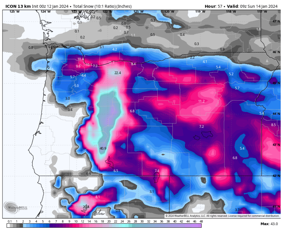
-
January 2024 Weather in the PNW (Part II)
Mid Valley Duck replied to Meatyorologist's topic in West of the Rockies
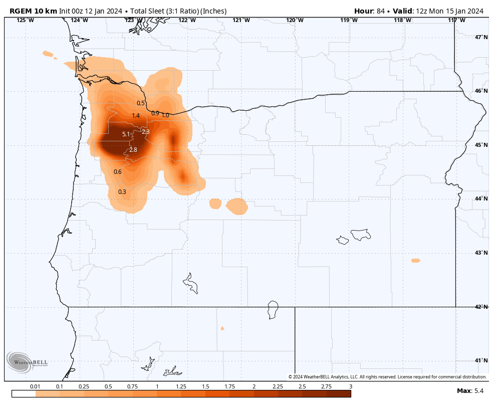
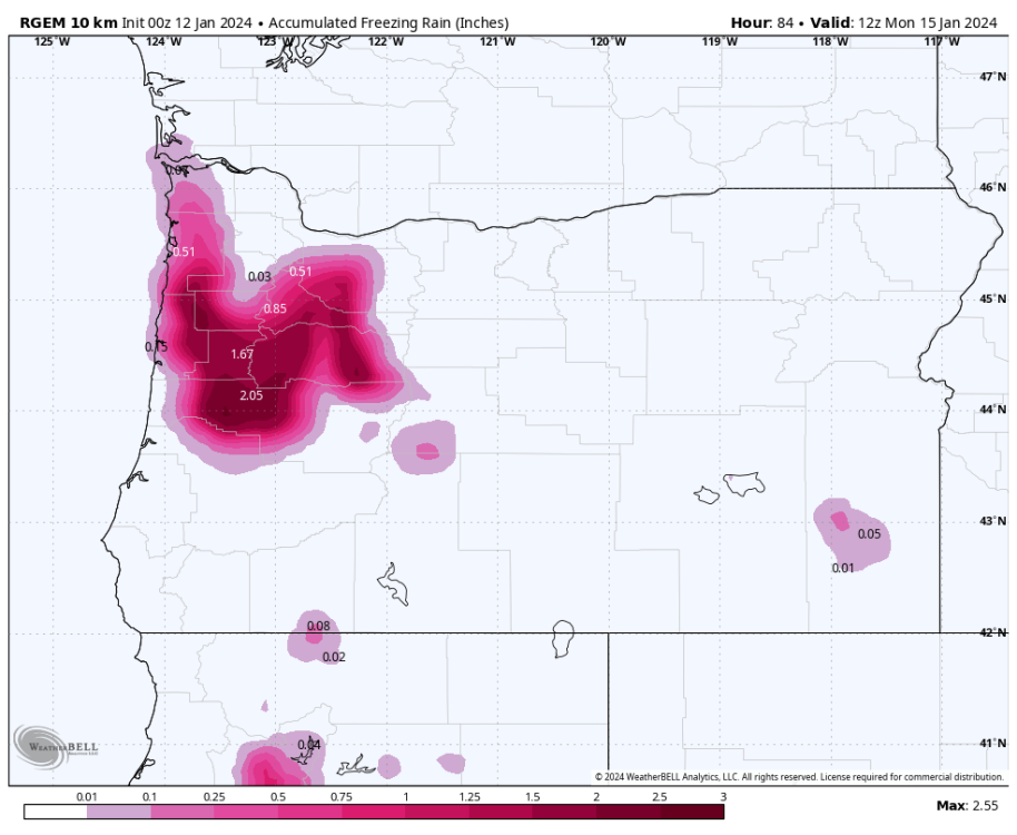
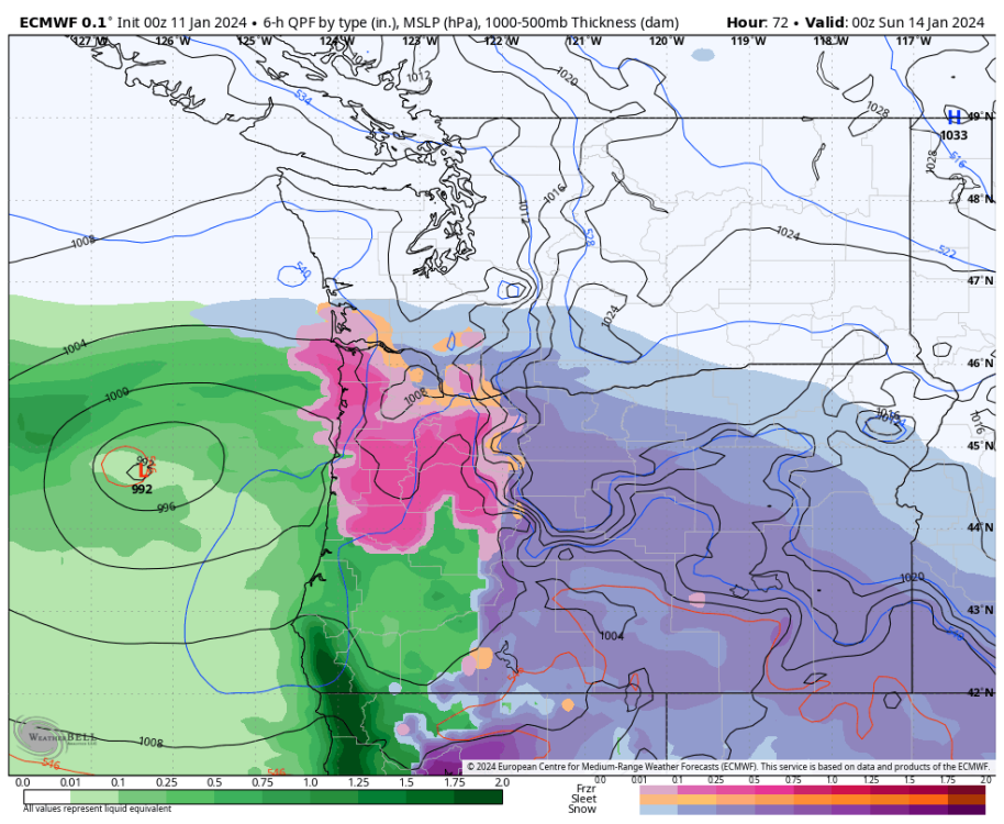
The RGEM put out some insane precip totals with some crazy freezing rain and sleet totals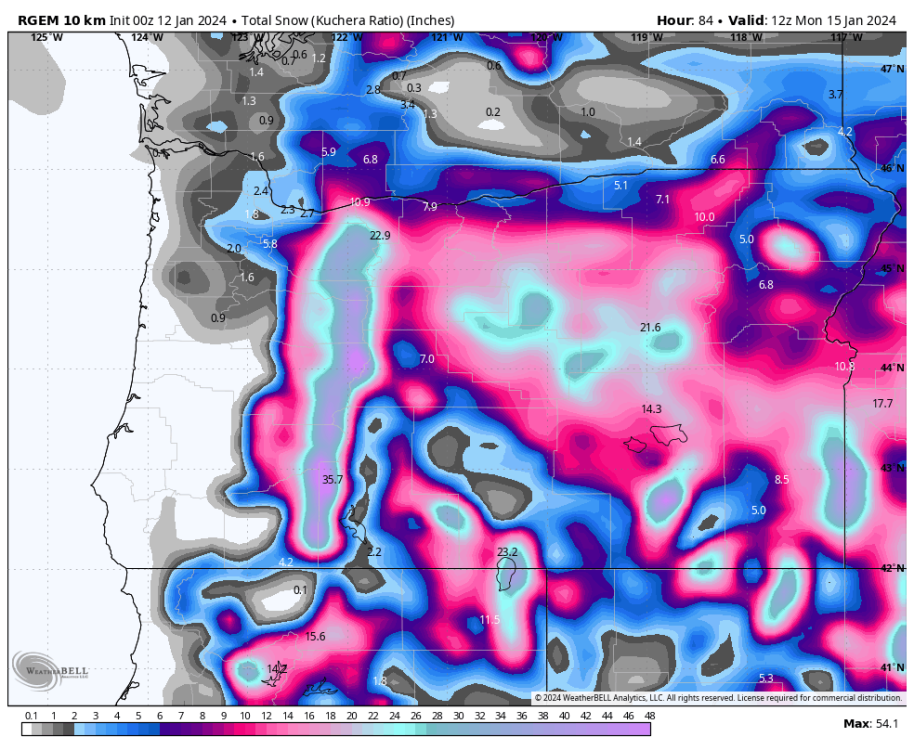

-
January 2024 Weather in the PNW (Part II)
Mid Valley Duck replied to Meatyorologist's topic in West of the Rockies
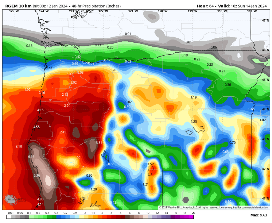
The mesoscale models are very bearish compared to the global ops. It’s going to be an interesting battle, not going to lie. I’m a little worried about a major bust -
January 2024 Weather in the PNW (Part II)
Mid Valley Duck replied to Meatyorologist's topic in West of the Rockies
Holy hell that is a horrific run. It’s crazy it’s so different from everything else -
January 2024 Weather in the PNW (Part II)
Mid Valley Duck replied to Meatyorologist's topic in West of the Rockies
Marky Mark is going to bust on amounts
-
January 2024 Weather in the PNW (Part II)
Mid Valley Duck replied to Meatyorologist's topic in West of the Rockies
Pretty cool to watch the battle between the incoming low pressure system and the cold arctic continental air. Going to be a helluva storm for those where these meet.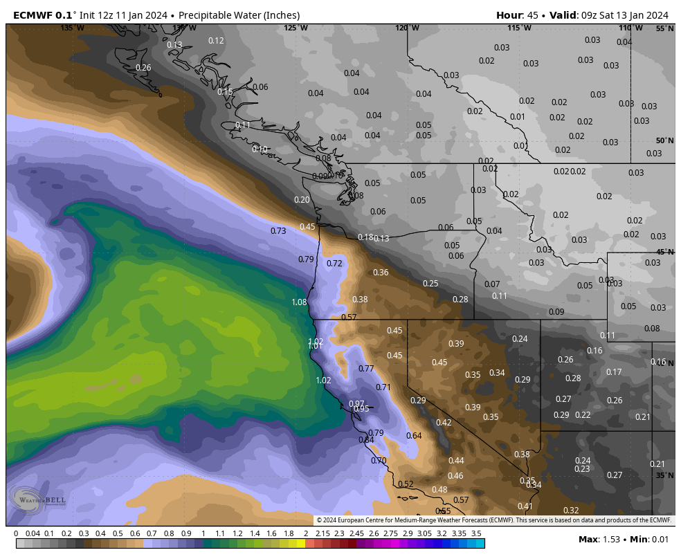
-
January 2024 Weather in the PNW (Part II)
Mid Valley Duck replied to Meatyorologist's topic in West of the Rockies
What happened in 68? What were the regional snow/ice totals? -
January 2024 Weather in the PNW (Part II)
Mid Valley Duck replied to Meatyorologist's topic in West of the Rockies
I live 4 miles south of the Marion/Linn county line. It'll be interesting to see the mix I get. Widely varies by the model you are looking at. It does seem like with the first surface low it will be mostly or all snow. The second low it seems like it'll be no snow and all sleet/freezing rain. -
January 2024 Weather in the PNW (Part II)
Mid Valley Duck replied to Meatyorologist's topic in West of the Rockies
One thing I've noticed looking at the models for last night and this morning is the mesoscale models are much more bearish on QPF than the operational. I wonder why that is the case. Seems like this system will have pretty good dynamics to it and the low is trending stronger. Anyone know why that might be the case? -
January 2024 Weather in the PNW (Part II)
Mid Valley Duck replied to Meatyorologist's topic in West of the Rockies
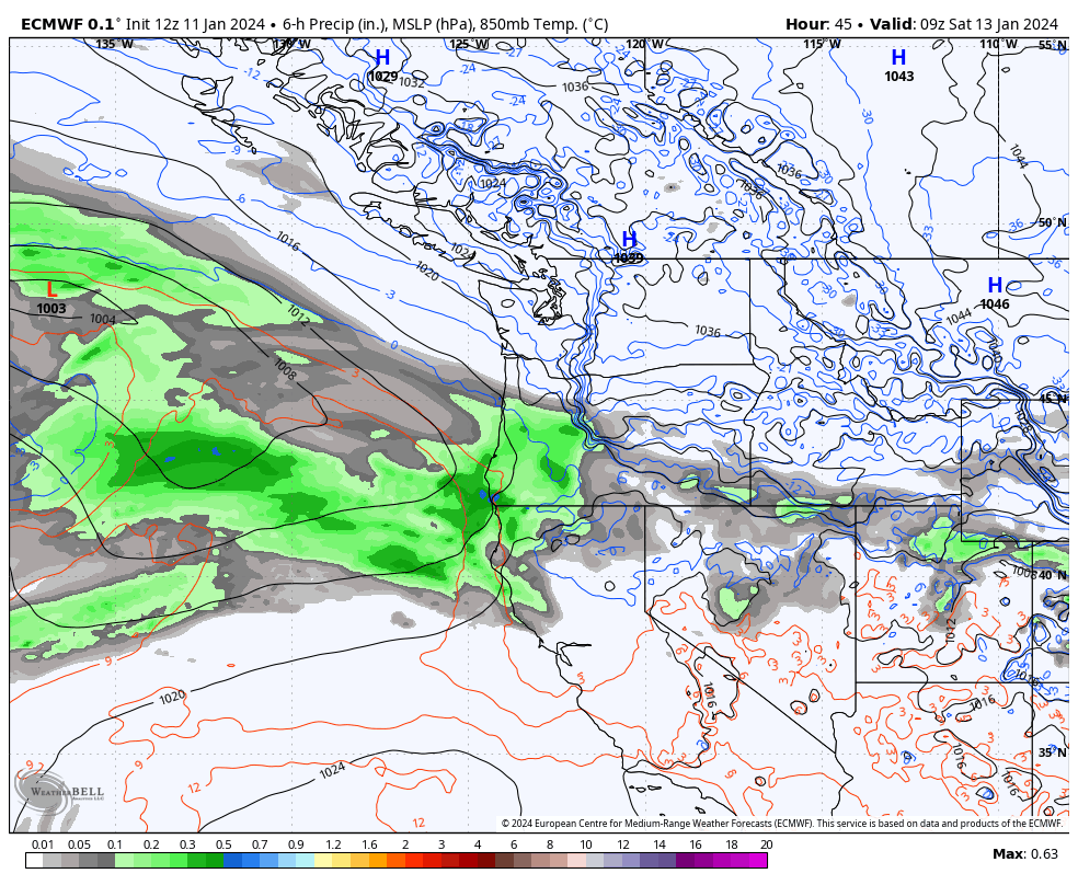
Not sure I buy that precip shield being that far south. First low comes in around Florence, second around Coos Bay. -
January 2024 Weather in the PNW (Part II)
Mid Valley Duck replied to Meatyorologist's topic in West of the Rockies
Euro spreads it further north because the system is more developed. Landfall is near Coos Bay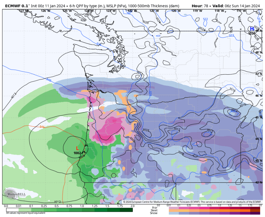
-
January 2024 Weather in the PNW (Part II)
Mid Valley Duck replied to Meatyorologist's topic in West of the Rockies
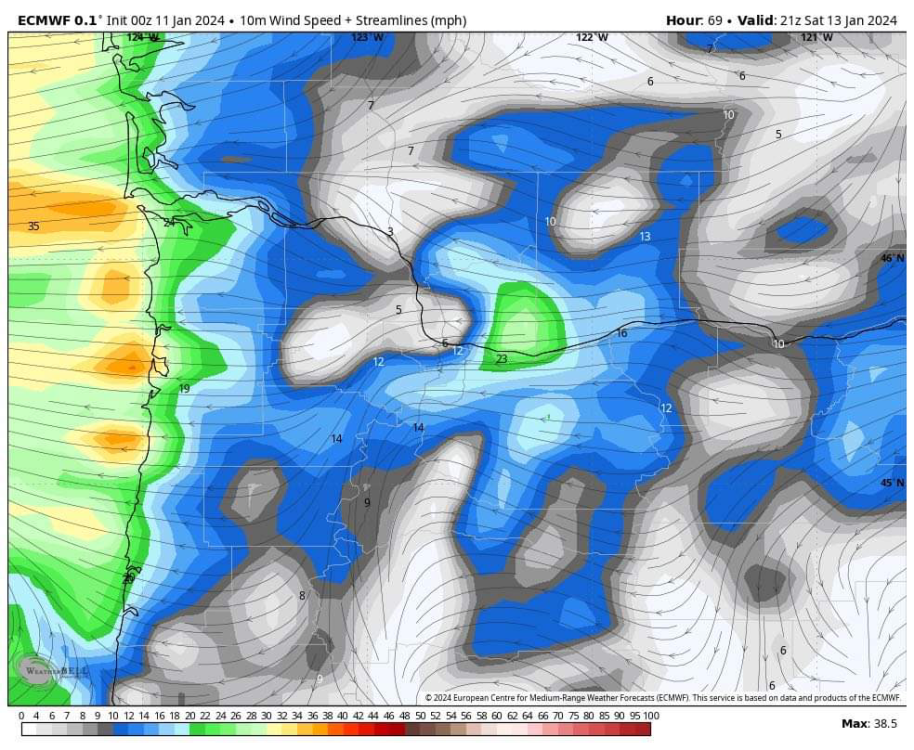
East wind monster hurts PDX snow totals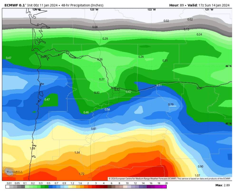
-
January 2024 Weather in the PNW (Part II)
Mid Valley Duck replied to Meatyorologist's topic in West of the Rockies
That snowfall happened largely in an 8 hour period. This is 3x as long as that. Honestly think this will surpass that. -
January 2024 Weather in the PNW (Part II)
Mid Valley Duck replied to Meatyorologist's topic in West of the Rockies
Congrats PDX friends!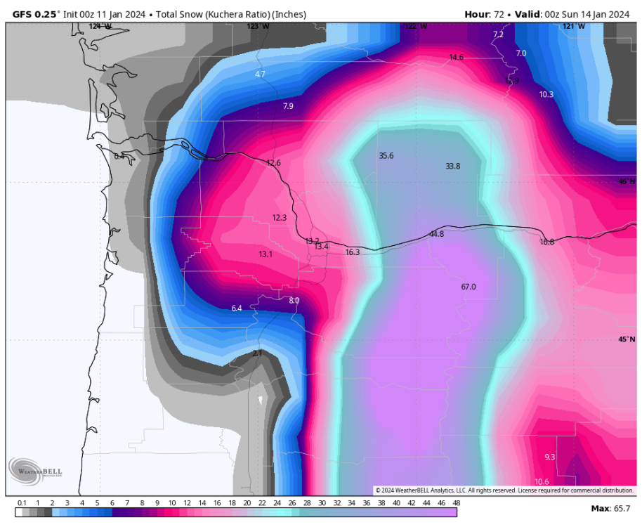
-
January 2024 Weather in the PNW (Part II)
Mid Valley Duck replied to Meatyorologist's topic in West of the Rockies
Gotta hand it to you Seattle folks, there is no quit in you despite overwhelming evidence you are going to get skunked. -
January 2024 Weather in the PNW (Part II)
Mid Valley Duck replied to Meatyorologist's topic in West of the Rockies
Yep you can tell very early on this will be south of the prior run -
January 2024 Weather in the PNW (Part II)
Mid Valley Duck replied to Meatyorologist's topic in West of the Rockies
Seattle folks have lost the Spire -
January 2024 Weather in the PNW (Part II)
Mid Valley Duck replied to Meatyorologist's topic in West of the Rockies
18z NAM. End frame, snow totals, sleet totals and freezing rain totals. -
January 2024 Weather in the PNW (Part II)
Mid Valley Duck replied to Meatyorologist's topic in West of the Rockies
From Mark Nelsen. The part I bolded caught my eye. Quick midday Wednesday update for you, I'll have a full blog post somewhere between 7-9pm this evening... 1) We're in this showers and sunbreaks routine through Thursday. Nothing really eventful except tons more snow in Cascades 2) Weather models now in very good agreement a tremendous blast of cold air pushes through Gorge and out into metro area on Friday. But do we freeze up at noon? Or not until after dark? Too early to know, but we DO know metro area will be frozen AT THE LATEST from Friday evening through MLK Day (Monday). Whatever falls from the sky (weatherwise) will be on the ground all weekend. 3) BUT...disagreement on whether we get moisture for snow on Friday and Saturday or does it stay mainly south of us? Models trending farther south and drier (but not all!) with the precipitation. So...we don't yet know if we're into a full snow/ice storm later Friday or just flurries that day and dry Saturday. Regardless... 4) Time to think about how you'll handle Friday if we wake up and temps are already dropping with snow beginning. That would be the best case scenario because most of us would just stay home and schools would cancel. Of course worst case is if we're well above freezing Friday and many head to work, only to get stuck on snowy/icy roads 2nd part of day. Luckily we have another day to nail down details, but I'm confident you DO need to cover faucets, wrap exposed pipes, drain outdoor water lines etc. Prepare for 15-20 degree temps in metro area this weekend with east wind gusts in the 40-55 mph range Friday night and Saturday morning. This image shows one of the "driest" models keeping snow and ice from Salem southward; at this point I think that's unlikely, although I wouldn't complain... MORE TO COME THIS EVENING... -
January 2024 Weather in the PNW (Part II)
Mid Valley Duck replied to Meatyorologist's topic in West of the Rockies
As of now there are only 2 models that someone could reasonably consider that show snow north of PDX. The GFS and Spire (12z run doesnt come in for 2 more hours) -
January 2024 Weather in the PNW (Part II)
Mid Valley Duck replied to Meatyorologist's topic in West of the Rockies
EPS is continuing to trend south.
-
January 2024 Weather in the PNW (Part II)
Mid Valley Duck replied to Meatyorologist's topic in West of the Rockies
Graphcast is way south. PDX stays completely dry. Salem to Eugene gets clipped. -
January 2024 Weather in the PNW (Part II)
Mid Valley Duck replied to Meatyorologist's topic in West of the Rockies
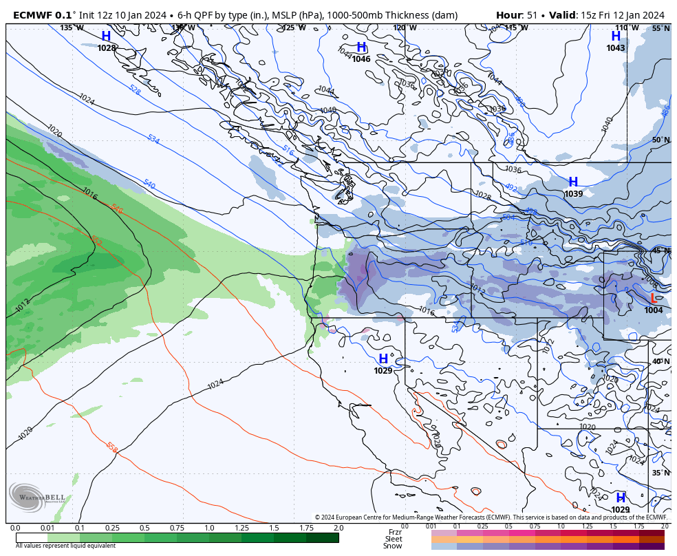
I don't think so, could be wrong though. At hour 51 they are basically in the same spot. But the GFS develops the system nicely, while the Euro keeps it very weak until it makes final approach toward the coast. The weaker Euro goes SE while the GFS goes ESE from this point. -
January 2024 Weather in the PNW (Part II)
Mid Valley Duck replied to Meatyorologist's topic in West of the Rockies
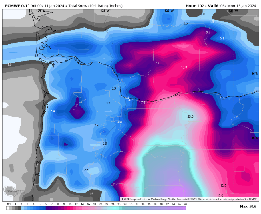
Yeah a pretty good snowstorm, 10:1 puts me at about 7", kuchera would put me at 4" -
January 2024 Weather in the PNW (Part II)
Mid Valley Duck replied to Meatyorologist's topic in West of the Rockies
One thing it did make a move towards the others with is the 2 low structure with a weaker surface low out ahead of the parent low. But significantly less development than the GFS has.