Mid Valley Duck
-
Posts
426 -
Joined
-
Last visited
Everything posted by Mid Valley Duck
-
January 2024 Weather in the PNW (Part II)
Mid Valley Duck replied to Meatyorologist's topic in West of the Rockies
Finally develops the low off the coast but it's right at the OR/CA border. -
January 2024 Weather in the PNW (Part II)
Mid Valley Duck replied to Meatyorologist's topic in West of the Rockies
Euro just refuses to develop the low compared to the GFS. -
January 2024 Weather in the PNW (Part II)
Mid Valley Duck replied to Meatyorologist's topic in West of the Rockies
This may come across as total wishcasting but this gives me vibes of a hybrid between Jan 2004 and Feb 2014. -
January 2024 Weather in the PNW (Part II)
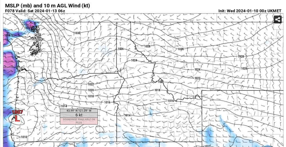
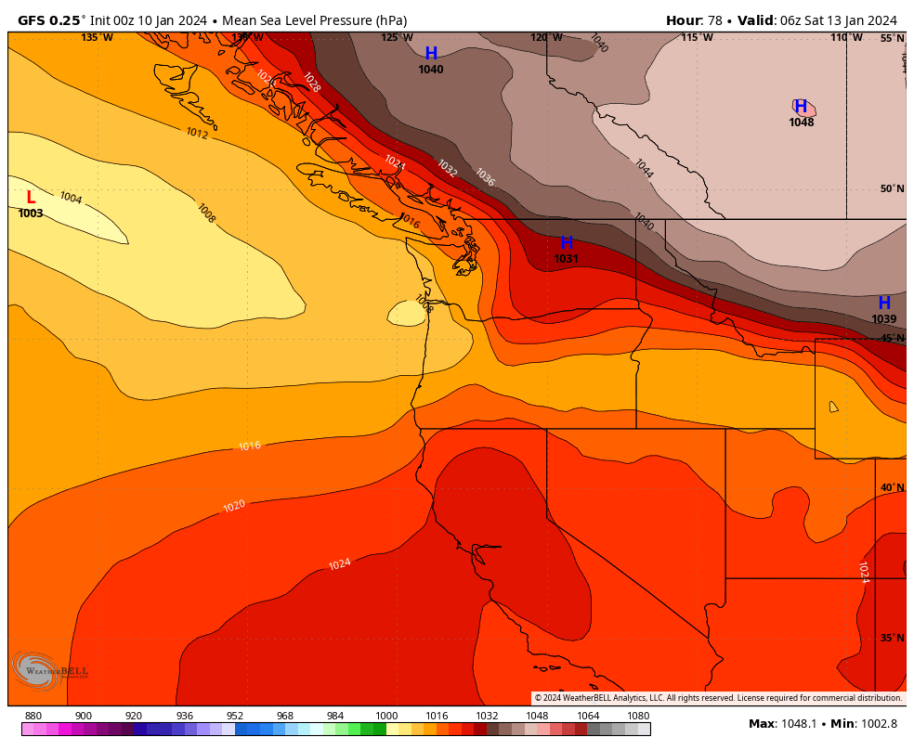
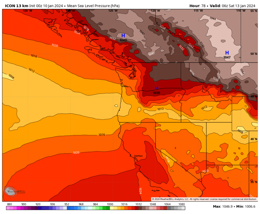
Mid Valley Duck replied to Meatyorologist's topic in West of the Rockies
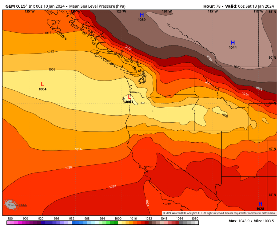
UKMET is about 350 miles south of the GFS and 100 miles south of the GEM with the low at hour 78. GFS UKMET GEM


-
January 2024 Weather in the PNW (Part II)
Mid Valley Duck replied to Meatyorologist's topic in West of the Rockies
Way south.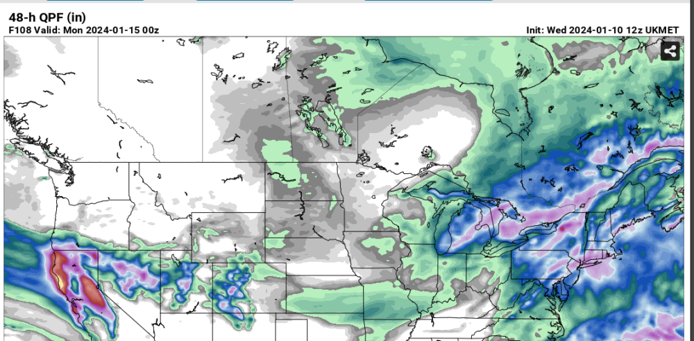
-
January 2024 Weather in the PNW (Part II)
Mid Valley Duck replied to Meatyorologist's topic in West of the Rockies
Slightly miss leading because even some of the far south ones dont give snow down the Willamette Valley. The easiest way to see the southern shift in the overall guidance is the 24 precip map. The GFS is still insistent on Seattle getting snow, just my opinion, I think north of Olympia will be dry.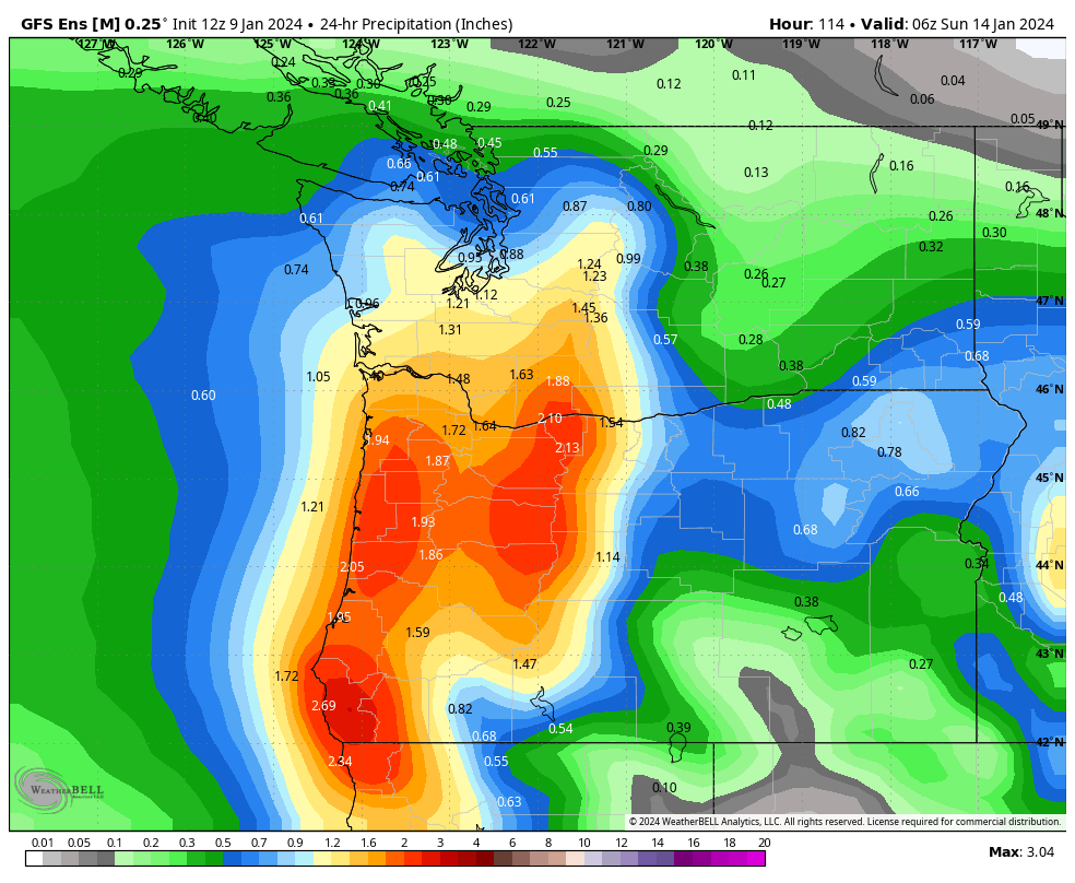
-
January 2024 Weather in the PNW (Part II)
Mid Valley Duck replied to Meatyorologist's topic in West of the Rockies
Right now the GFS is the only model with a significant precip shield to the north and northeast of the low's. Even the NAM and GEM has largely abandoned that idea. -
January 2024 Weather in the PNW (Part II)
Mid Valley Duck replied to Meatyorologist's topic in West of the Rockies
From your lips to God's ear! -
January 2024 Weather in the PNW (Part II)
Mid Valley Duck replied to Meatyorologist's topic in West of the Rockies
Clear trend to the south of the GFS. It's still significantly further north than all other guidance.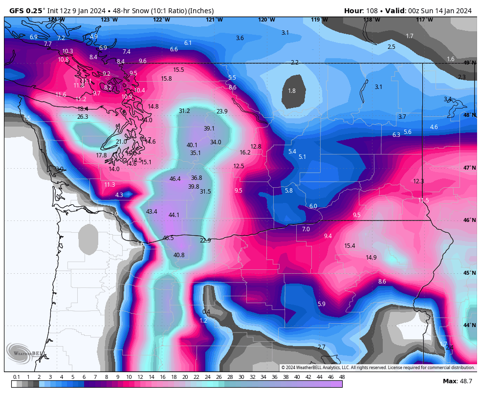
-
January 2024 Weather in the PNW (Part II)
Mid Valley Duck replied to Meatyorologist's topic in West of the Rockies
The GFS is going to look brilliant or incredibly stupid. -
January 2024 Weather in the PNW (Part II)
Mid Valley Duck replied to Meatyorologist's topic in West of the Rockies
FWIW 72 hours out for last nights event the ICON had that system south of TWL. So not sure how reliable it is with that far south of a solution. But at face value I wouldn’t even get any precip -
January 2024 Weather in the PNW (Part II)
Mid Valley Duck replied to Meatyorologist's topic in West of the Rockies
The 6z was extremely juicy so it’s probably the NAM just being the NAM. Honestly think you, me and TWL could end up the big winners. Which a day or two ago I would have thought it was impossible -
January 2024 Weather in the PNW (Part II)
Mid Valley Duck replied to Meatyorologist's topic in West of the Rockies
NAM looks a lot like last nights euro. -
January 2024 Weather in the PNW (Part II)
Mid Valley Duck replied to Meatyorologist's topic in West of the Rockies
12z NAM is a lot weaker and further south with the surface low out ahead of the parent low. The way things are trending down the home stretch TWL might be the big winner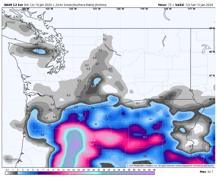
-
January 2024 Weather in the PNW (Part II)
Mid Valley Duck replied to Meatyorologist's topic in West of the Rockies
Also looks further south and with less precip. The 6z NAM was epic from Salem to PDX (6-12”) with more on the way. We’ll see about this run. -
January 2024 Weather in the PNW (Part II)
Mid Valley Duck replied to Meatyorologist's topic in West of the Rockies
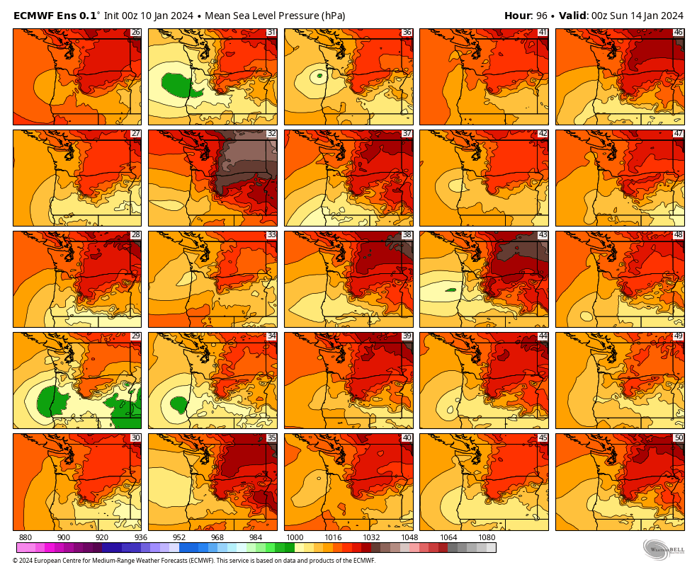
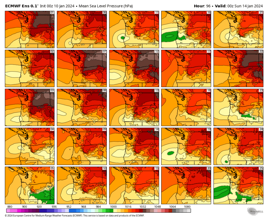
EPS low locations have really centered on the area between Newport and Coos Bay. Some are as far south as Eureka and some as far north as Seaside. But the bulk go between Newport and Coos Bay.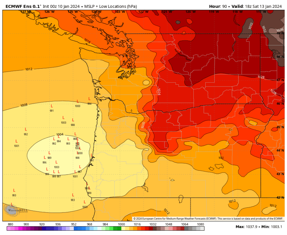

-
January 2024 Weather in the PNW (Part II)
Mid Valley Duck replied to Meatyorologist's topic in West of the Rockies
About 0.5”-1” for PDX south to Corvallis, but shifted the northern extent south. Here’s the 0z then the 12z

-
January 2024 Weather in the PNW (Part II)
Mid Valley Duck replied to Meatyorologist's topic in West of the Rockies
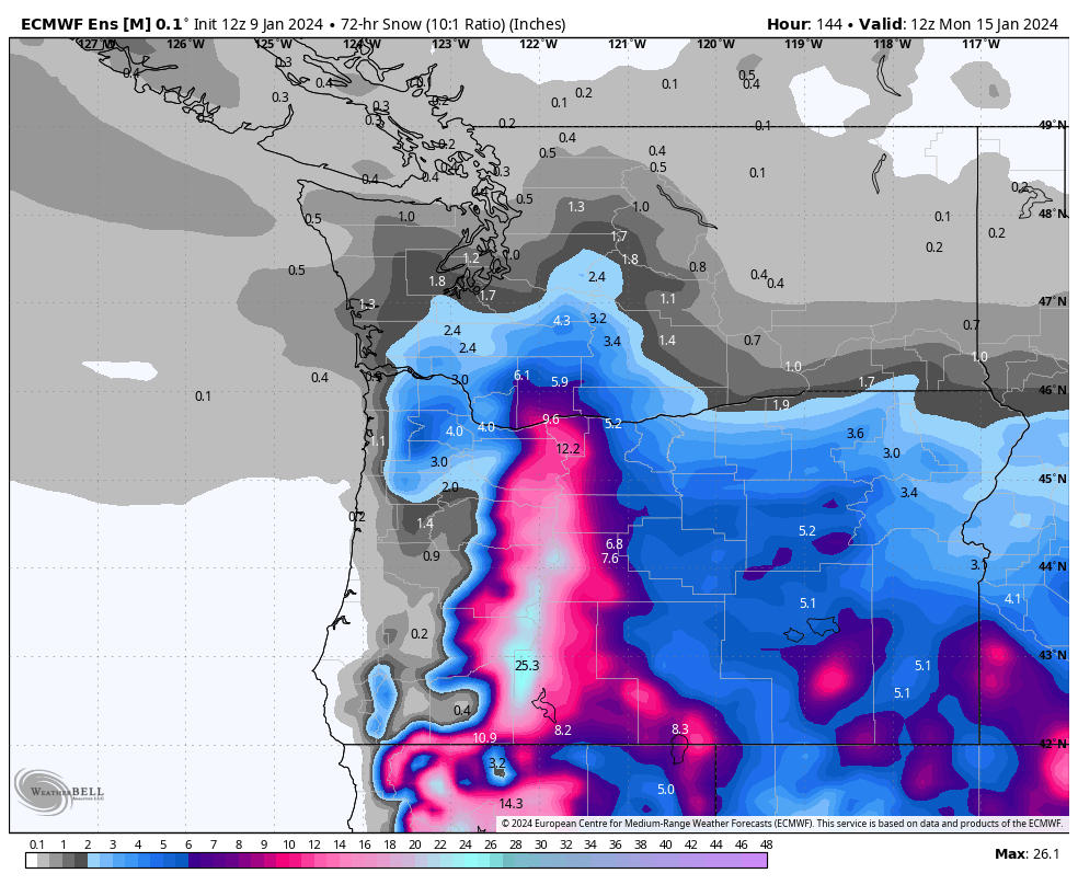
EPS mean snowfall from 4am Friday to 4am Monday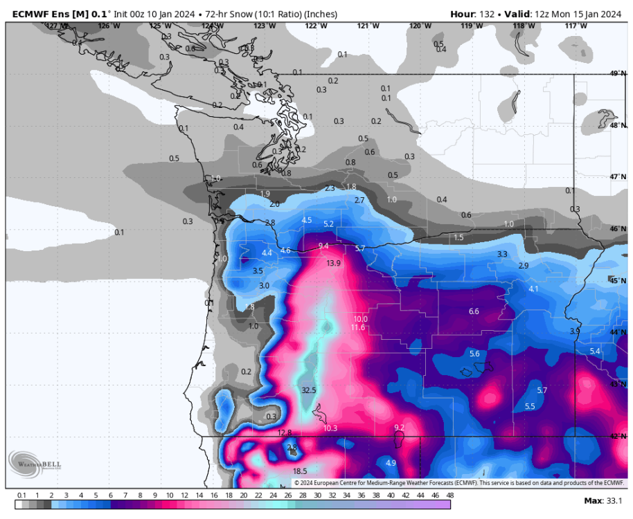
-
January 2024 Weather in the PNW (Part II)
Mid Valley Duck replied to Meatyorologist's topic in West of the Rockies
It’s plenty strong with the parent low. It just isn’t buying a strong surface low out ahead of it. GFS, GEM and ICON all develop one. The Euro doesn’t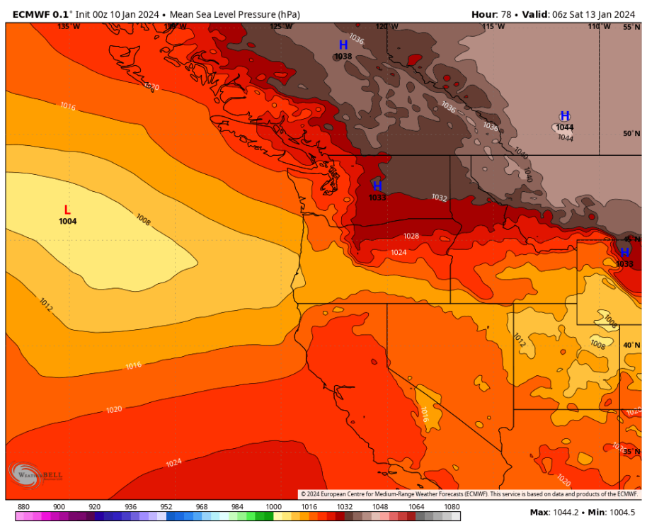
-
January 2024 Weather in the PNW (Part II)
Mid Valley Duck replied to Meatyorologist's topic in West of the Rockies
The GFS while whiffing horribly on some big picture aspects of this might be getting that piece right. While it’s the opposite for the euro. -
January 2024 Weather in the PNW (Part II)
Mid Valley Duck replied to Meatyorologist's topic in West of the Rockies
No first low. The second low is the parent low. The Euro is bearish on the surface low developing out ahead of the parent low. The Euro and UKMET say no to that feature. The NCEP products and GEM say yes. For Oregon we'd want the structure to be the GFS with the Euro's track and landfall. -
January 2024 Weather in the PNW (Part II)
Mid Valley Duck replied to Meatyorologist's topic in West of the Rockies
Euro is very dry. The GFS is world's apart with track, landfall and QPF with that system. The euro doesnt even show the surface low out ahead of the parent low. -
January 2024 Weather in the PNW (Part II)
Mid Valley Duck replied to Meatyorologist's topic in West of the Rockies
Euro is just so dry to the NE side of the low. -
January 2024 Weather in the PNW (Part II)
Mid Valley Duck replied to Meatyorologist's topic in West of the Rockies
Can't say I've ever seen an ensemble shift to this degree in one run inside of 4 days -
January 2024 Weather in the PNW (Part II)
Mid Valley Duck replied to Meatyorologist's topic in West of the Rockies
UKMET landfall is Coos Bay but the precip shield is shunted far to the south. My house doesnt even get a half an inch of precip.