

Ken in Wood Village
-
Posts
780 -
Joined
-
Last visited
-
Days Won
8
Posts posted by Ken in Wood Village
-
-
5 minutes ago, SunAndSnow said:
19 and we’re getting some flurries with that band!
Looks like a heavier precipitation is knocking on your doorstep


-
 1
1
-
-
Some very light precipitation from just South of Portland down past to almost Eugene. It's showing green further South but I'm hoping it will be snow for you all
-
3
-
-
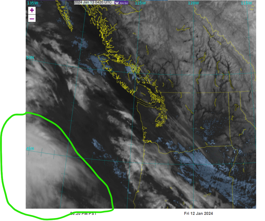
Look at that beautiful baby starting to come to the PNW
isn't she beautiful  I'm surprised that with the amount of cloud shield, that there isn't any moisture in those clouds like the models are showing
  I'm thinking the models are wrong and this will be a regional weather event for the whole PNW
-
8
-
-
The NWS upped the snow totals
-
7
-
 1
1
-
-
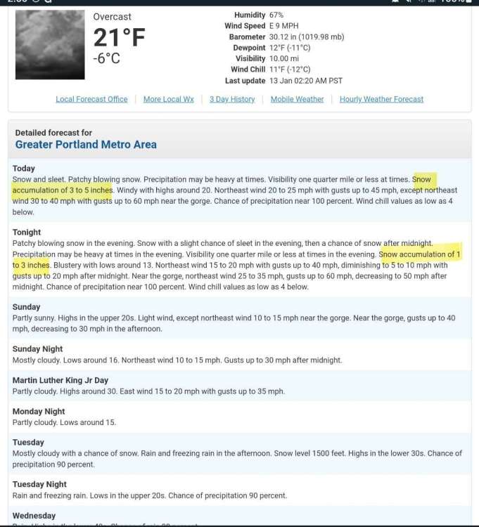
Check that out everyone
look at the shield of precipitation which I believe is SNOW

-
4
-
 1
1
-
-
Last post for a couple of hours. I'm going to head to bed. Need some sleep but I most likely get up and look at the radar. I really wish the Portland radar was working

-
5
-
-
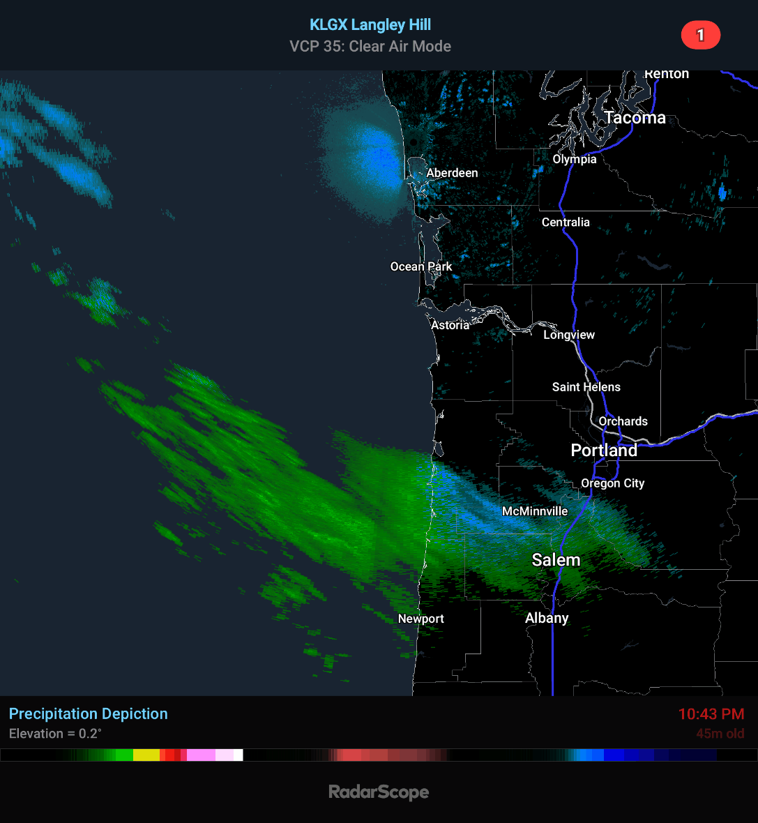
Look to the NW of Astoria
I did a close up of the Salem area too.
.thumb.gif.735a648428e13be453073e6e31a97fec.gif)
-
2
-
3
-
-
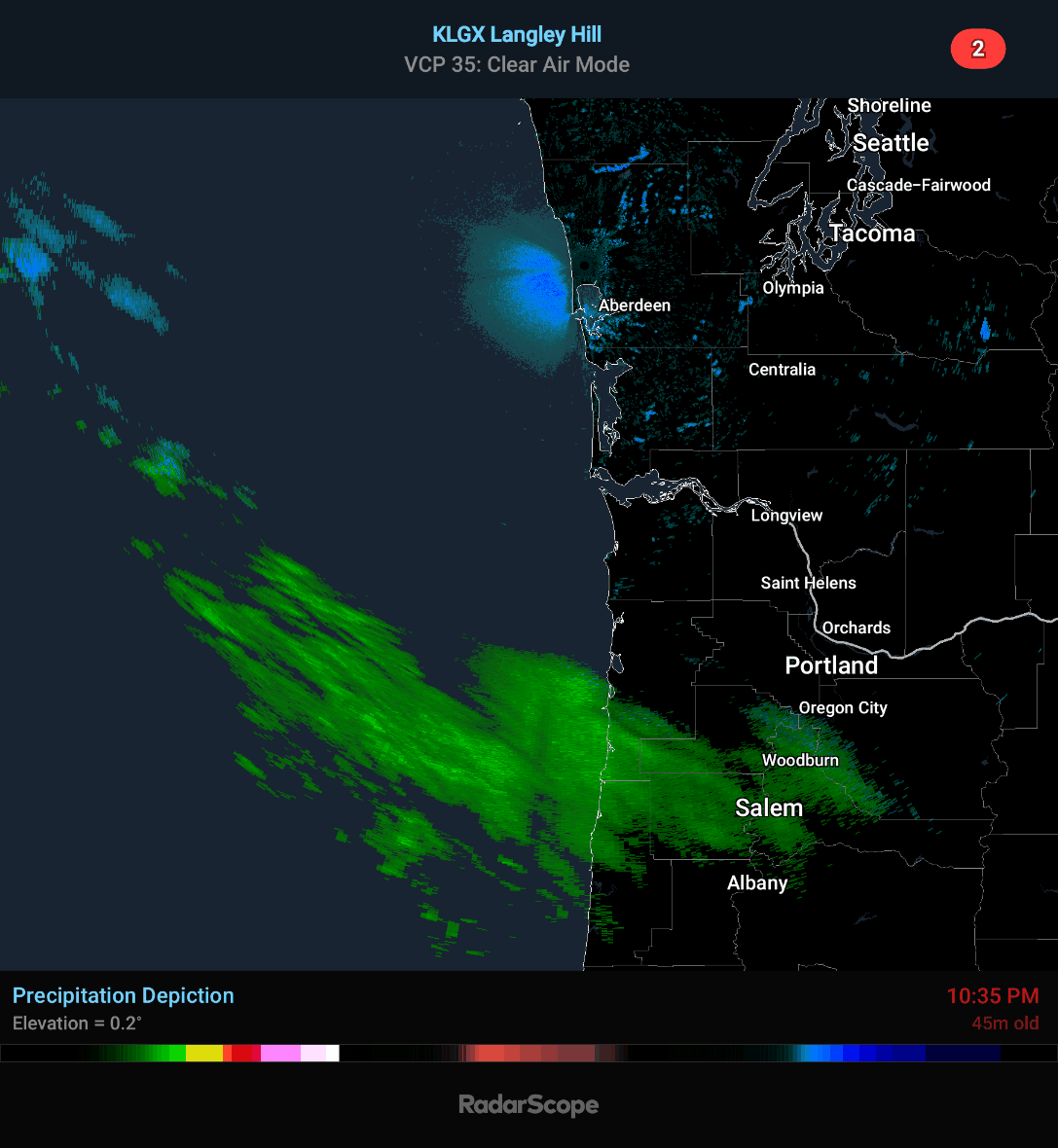
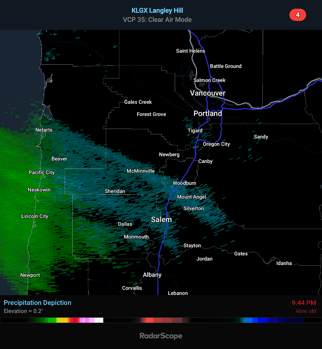
Someone posted something about it could be snowing in the Portland area around 1am. I think you could be right. Look how close those snow showers are coming to Portland
it probably very light snow showers 🌨
-
5
-
1
-
-
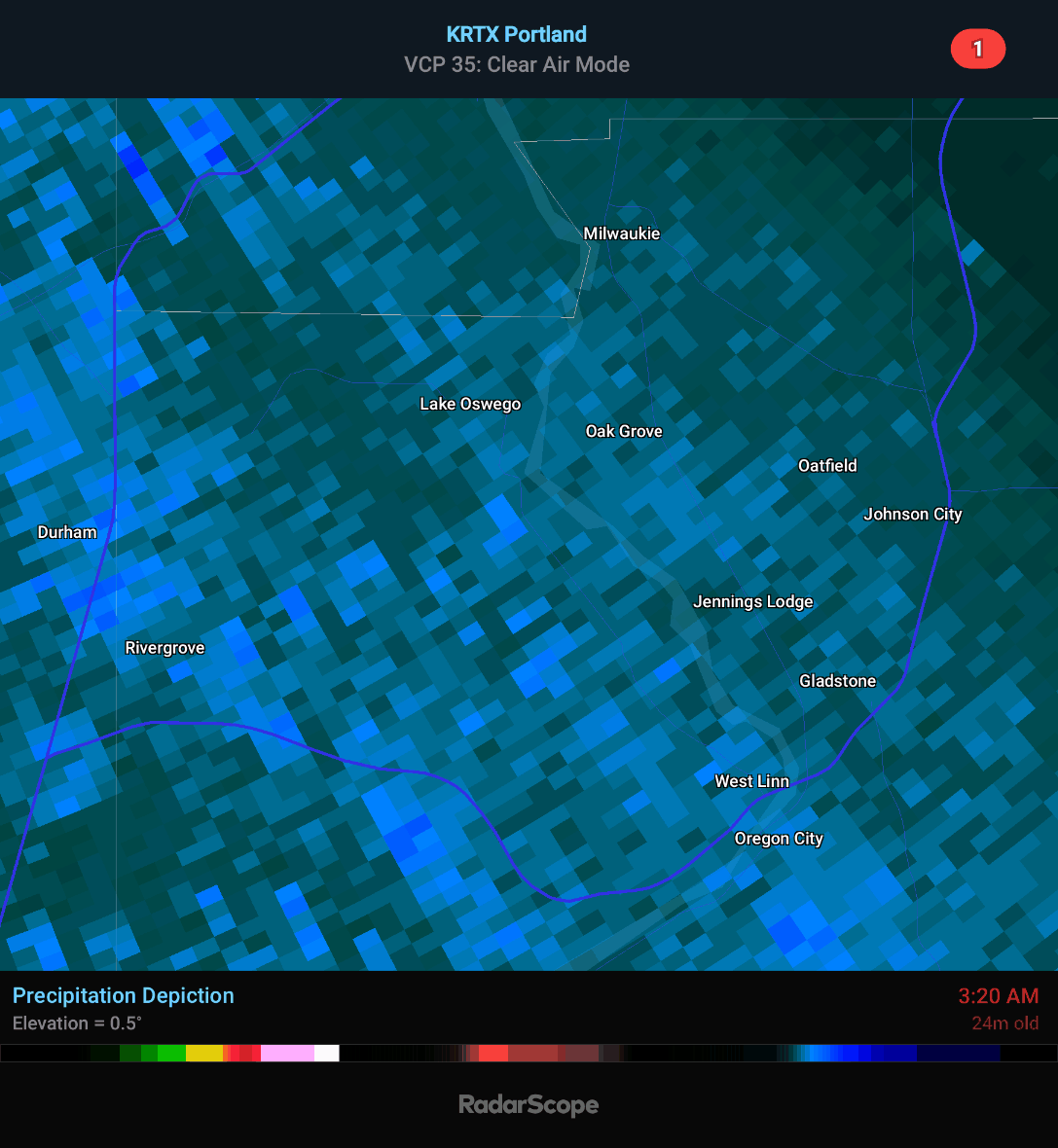
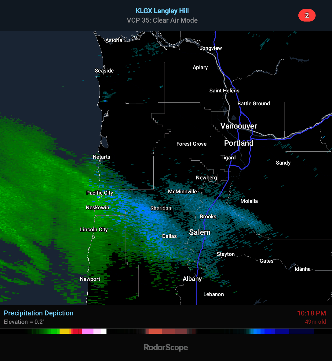
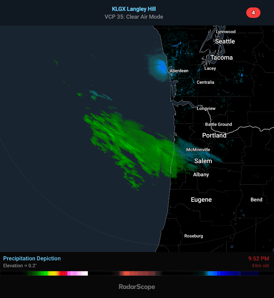
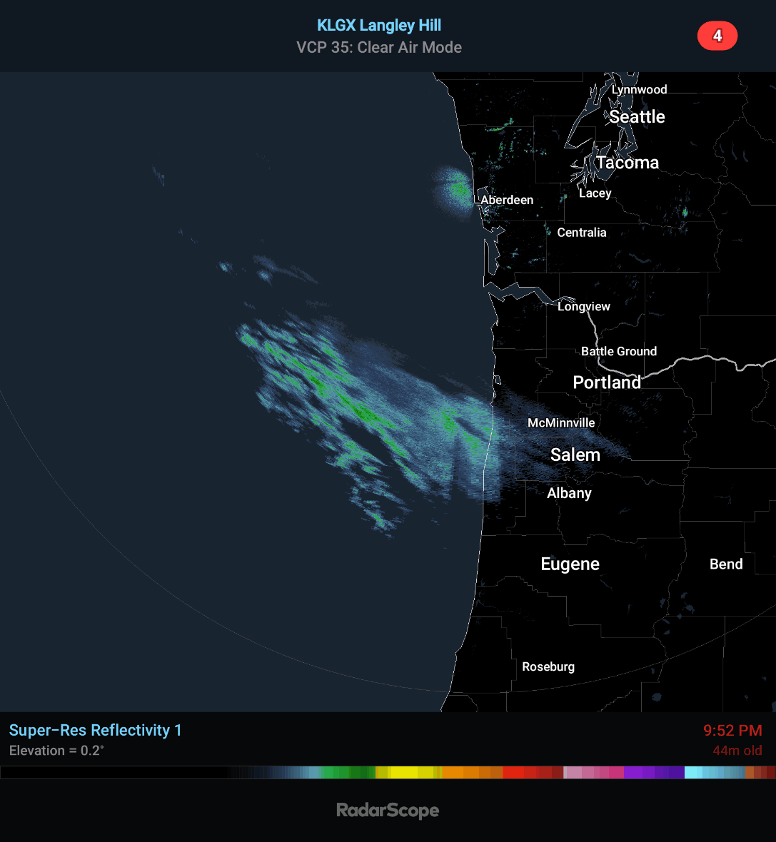
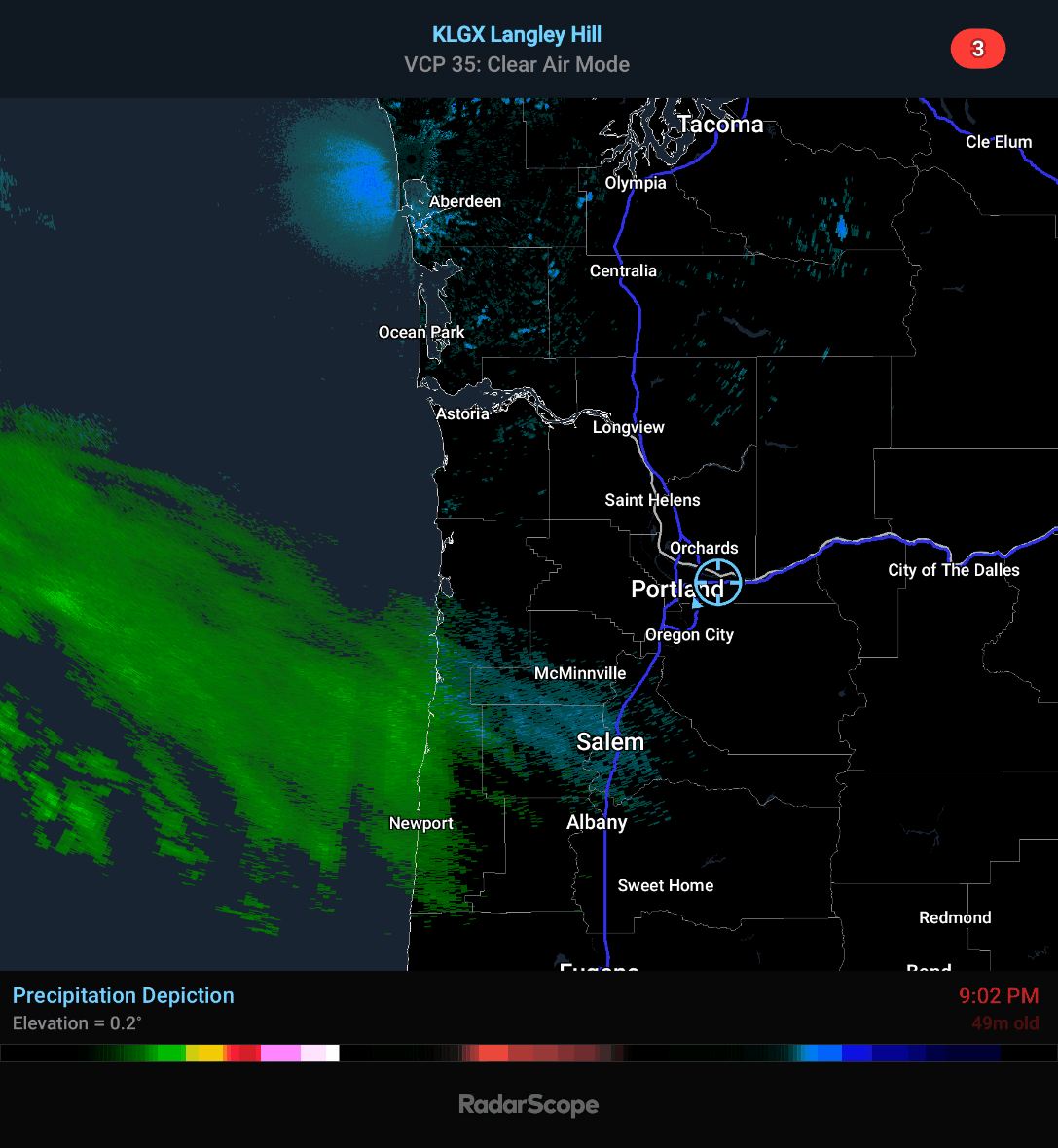
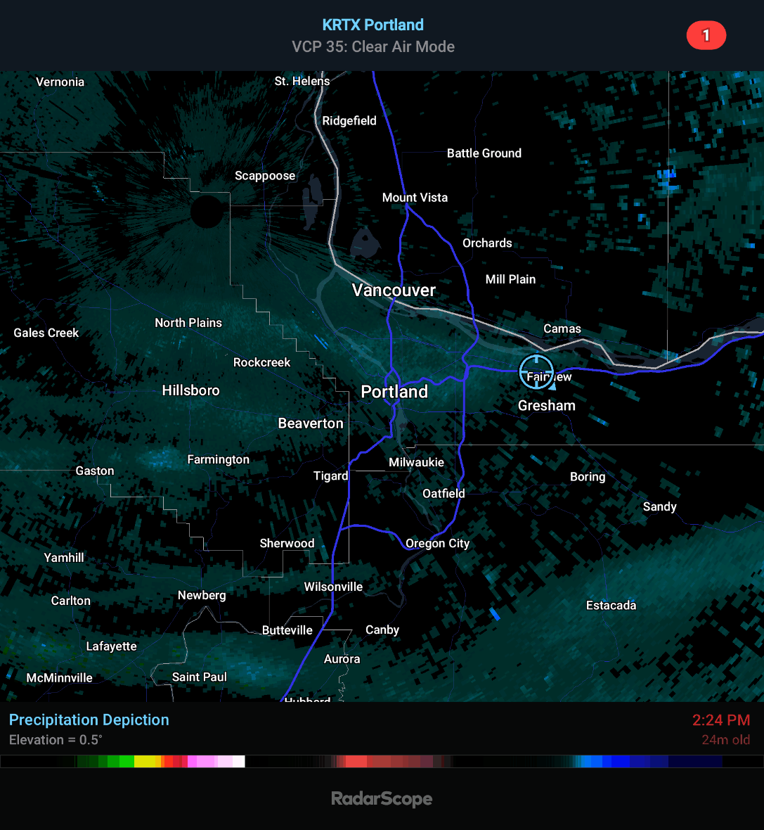
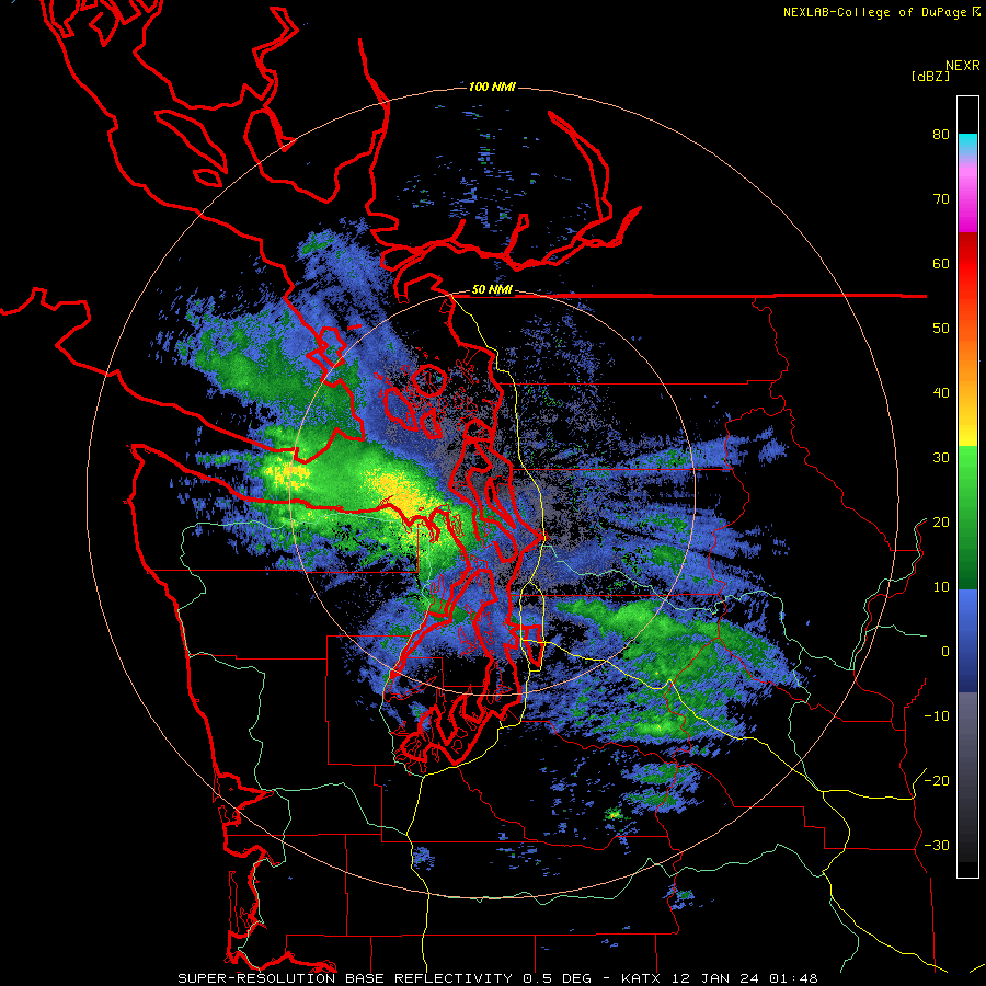
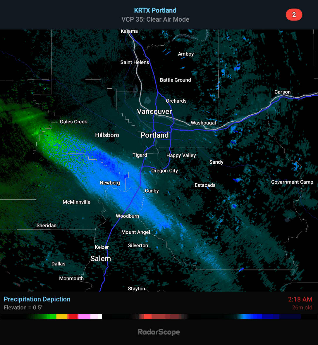
I'm just showing the difference between Clear Air Mode compared to High Resolution. Snow is actually really hard for the radar to pick up on High Resolution because of the cross section of a snowflake. I have noticed the band getting closer to the Portland area
🌨
-
3
-
-
2 minutes ago, Perturbed Member said:
Salem 27F and reporting snow. The returns moving up on radar appear to be real and reaching the ground.
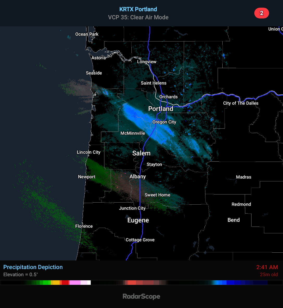
Since the Portland radar is down, I'm using the Langley radar so the echoes may not be that strong but it looks like it's snowing
🌨
-
5
-
2
-
-
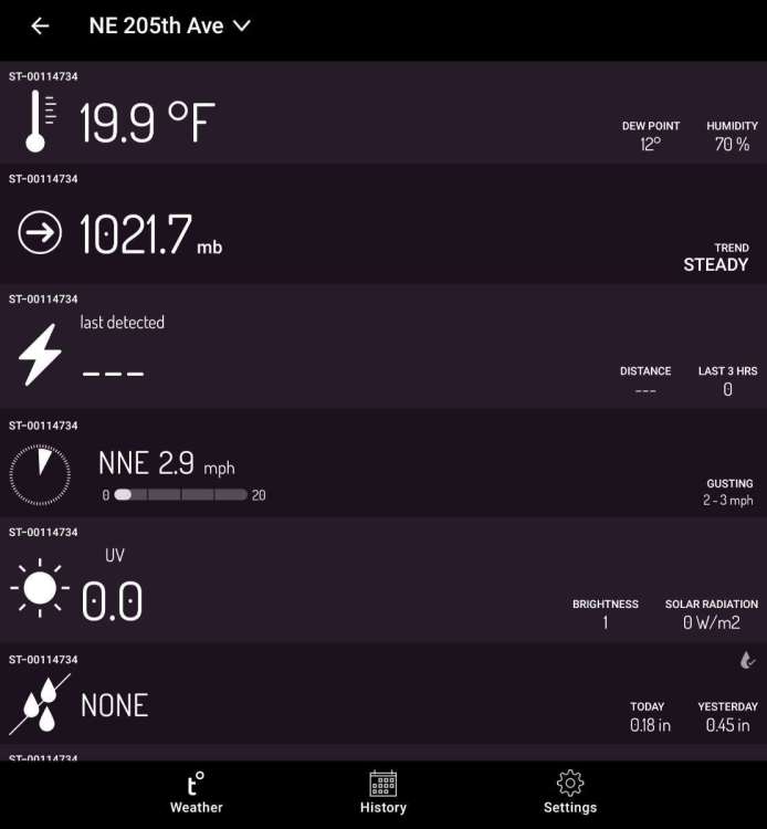
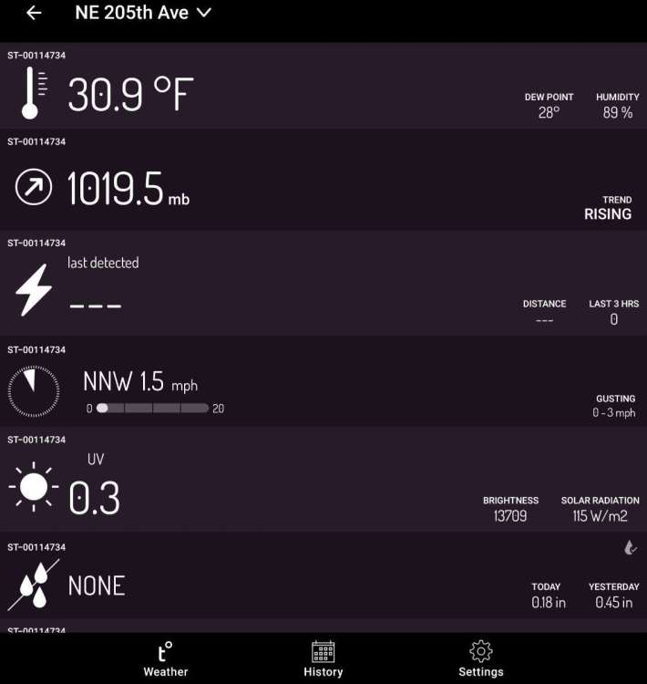
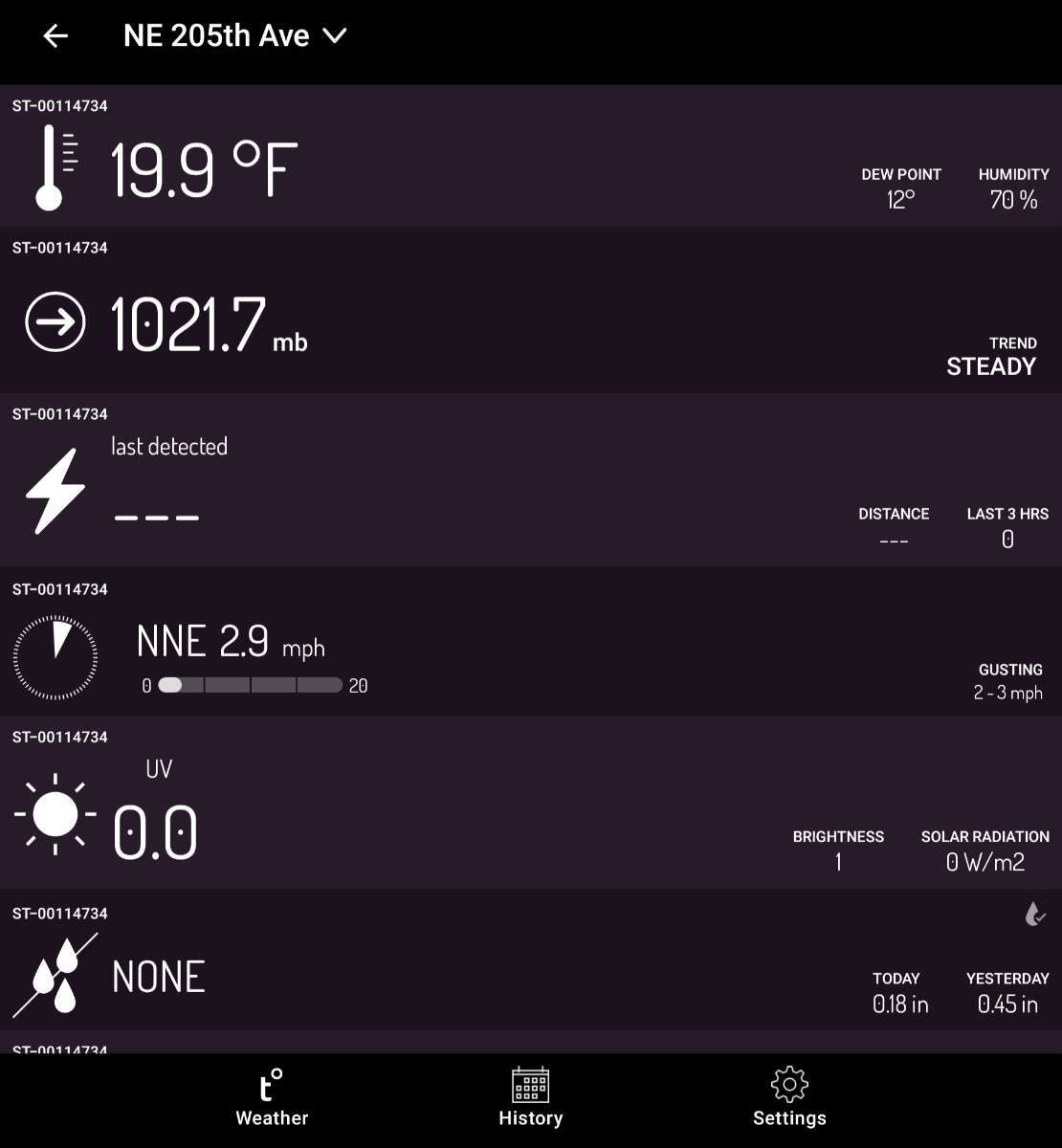
Temperature is barely below 20° degrees


-
9
-
-
3 minutes ago, Slushy Inch said:
Great timing for Portlands radar to be down
This sucks
 Every single time a major weather event is about to happen, the radar goes down
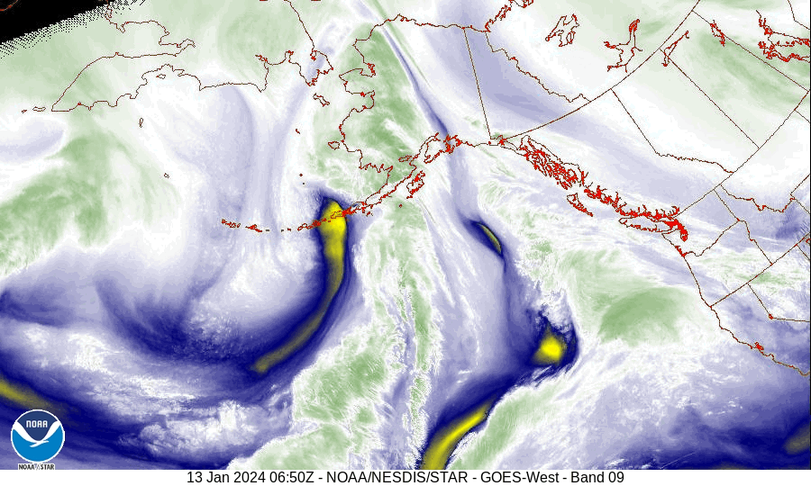
Here is the Langley radar, it's picking up the moisture coming in.
-
4
-
-
1 minute ago, High Desert Mat? said:
Also want to say, when this all unfolded in the models two weeks ago, we kind of laughed it off like it was never going to happen. But it did. And the gfs led the way 80% of the time. It skewed off here and there but in the end it was the closest to reality. If that high in the eastern pacific would’ve held on a little stronger and a little longer, man, this would’ve been an all time air mass that rivaled any in the last 100 years. Yet it was t seen anywhere close to us two weeks ago. Crazy what SSW’s can do. From what I hear, another one is suppose to happen on the 24th.
This air mass reminds me of 1988 or 1989. I worked at Fred Meyer's and remembered hearing Alaska having temperatures -50° degrees and it was heading to the PNW. I went on my lunch and drove home (I didn't live that far away) and passed a temperature sign. It said it was 35 degrees and when I drove passed it again to get to work, it was down to 27. By the time I got off work, it was 15 degrees with a very strong East wind. This Arctic Air is similar to what happened then.
-
2
-
-
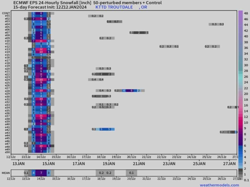
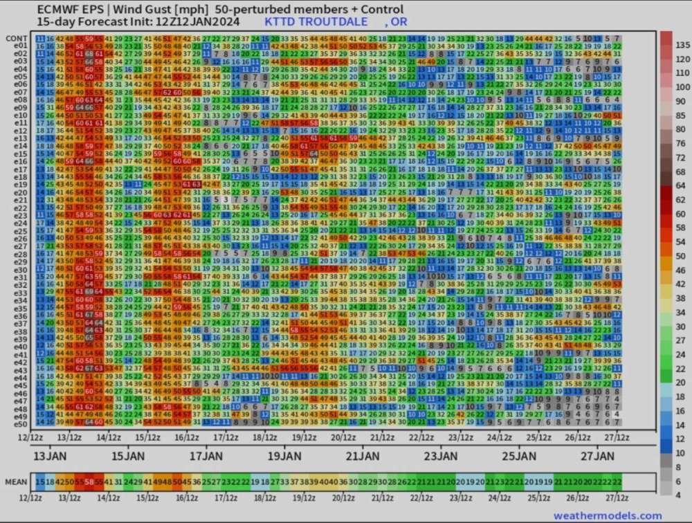
I'm not sure if anyone posted this today. I was working and every time I looked at the forum, there were a lot comments and didn't have time to go through them all.
The 12Z EPS really has a lot of members with high snow totals and check out the winds. I saw Mark Nelsen posted something on Facebook saying even the West Hills could see 60 mph winds late tonight and early morning. He said these could be damaging winds since 2009.
Tomorrow is going to be a very exciting day for everyone I think
🌨
-
4
-
 1
1
-
 1
1
-
-
21 minutes ago, GHweatherChris said:
There she is, the mama to my deformation band baby for tomorrow, isn't she dreamy....
I thought I would give everyone a better view. As @GHweatherChris would say "isn't she dreamy"

-
6
-
-
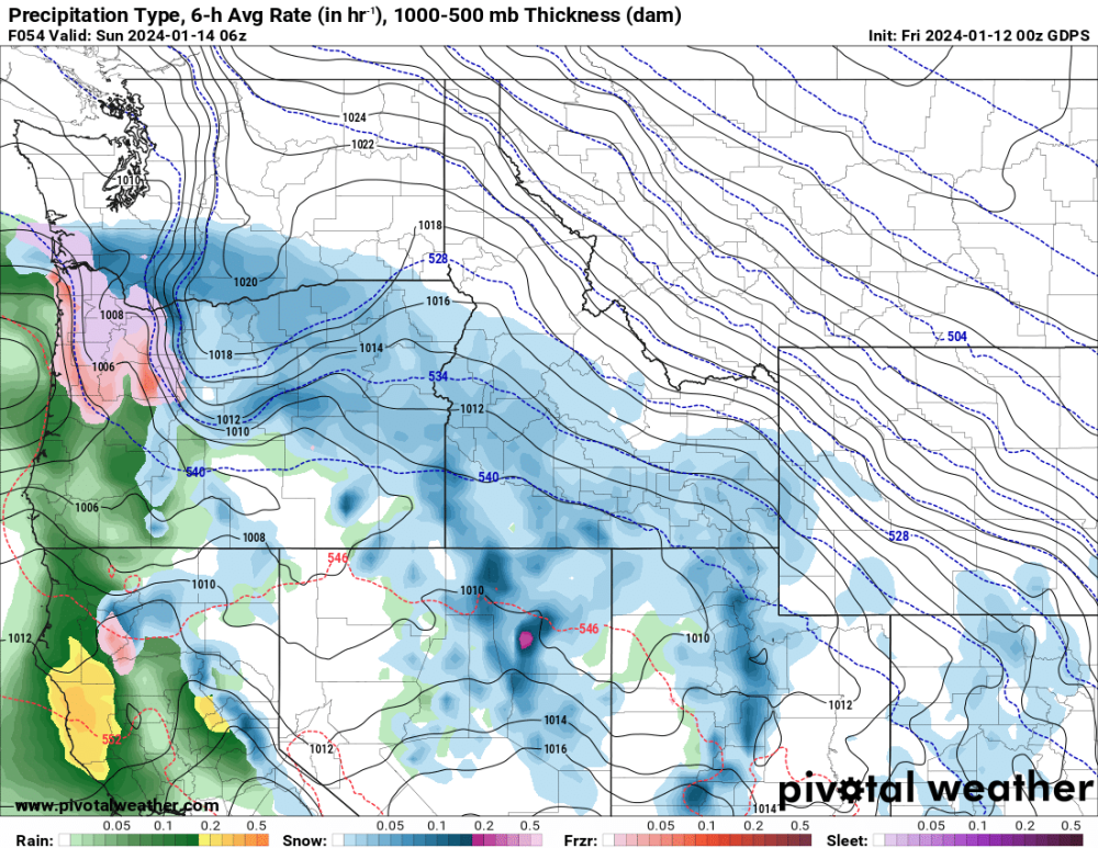
This is the 00Z HRRR. I want to remind everyone, this is a general representation of what the radar will look like not what actually will happen. I've learned that a long time ago. Someone will get a good amount of snow but we won't know until it actually happens. I think the models are over doing the freezing rain and sleet. I think those areas could see snow but we'll see if I'm right.
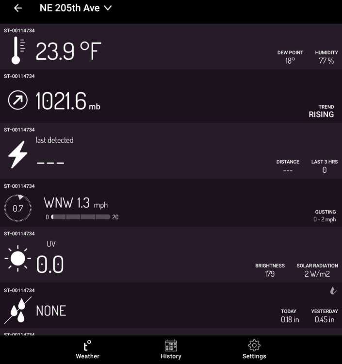
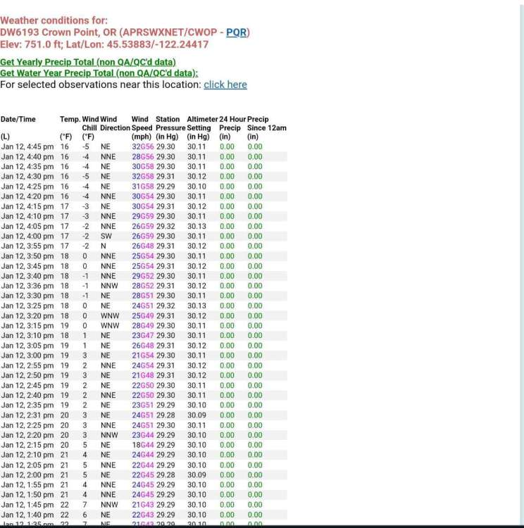
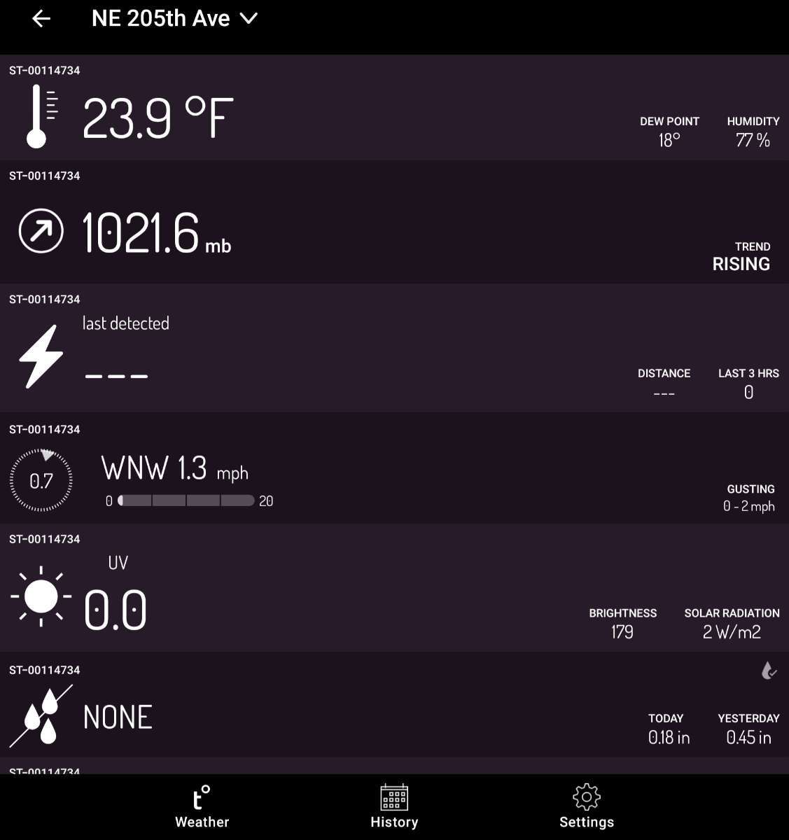
Temperature is down to 21° degrees with a dewpoint of 13° degrees. Crown Point is at 13° degrees with a windchill of -10° degrees
The next 24 hours are going to be very exciting
🌨
.gif.4c2553ed2e6ca658b66eb4b95af8f41d.gif)
-
5
-
1
-
1
-
-
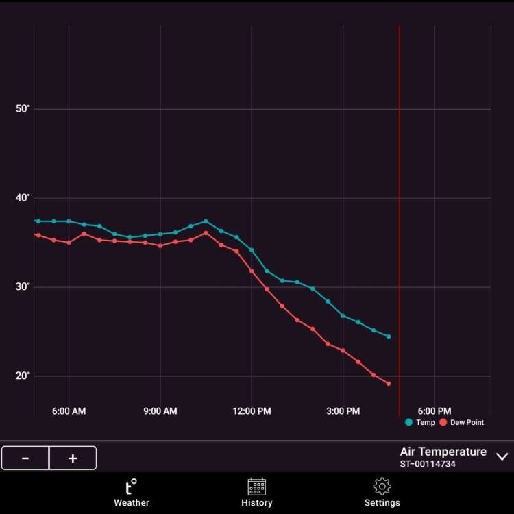
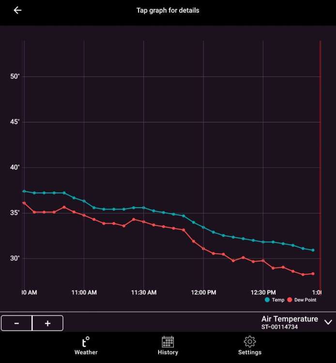
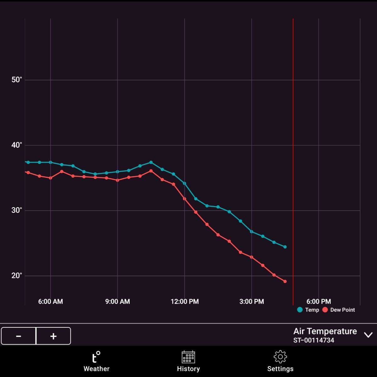
Such an amazing temperature drop today. A true Arctic Outbreak
🌨

-
6
-
 2
2
-
-
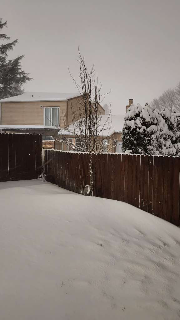
I put the radar into a different mode to pick up the lighter moisture. As you can see by the blue circle, there is some precipitation over me. Yes, it's lightly snowing. You can see a heavier band forming over the Beaverton area moving East. Hopefully that will get to me. Oh, temps are a around 27 now and the snow that's falling is starting to accumulate
🌨
-
5
-
-
I really hate being right
 I told people about the possibility of flash freezing and wouldn't you know it, the NWS issues this special weather statement
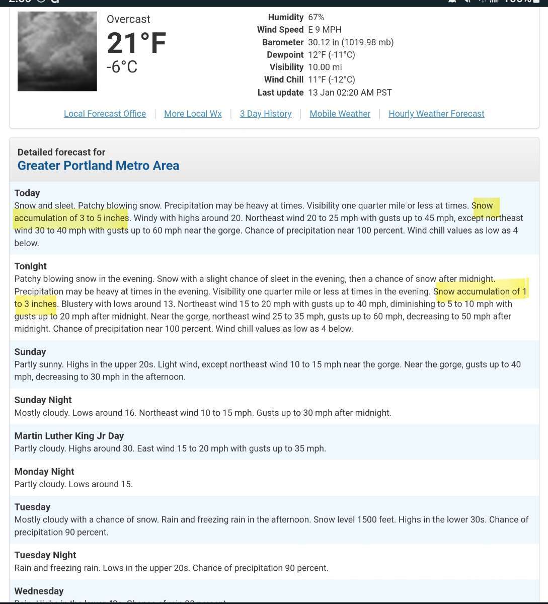
Special Weather Statement
National Weather Service Portland OR
1111 AM PST Fri Jan 12 2024

ORZ001-003-005-006-015-016-WAZ019>022-039-040-045-046-130600-
North Oregon Coast-Coast Range of Northwest Oregon-Lower Columbia-
Greater Portland Metro Area-Western Columbia River Gorge-
Central Columbia River Gorge-South Washington Cascades-
Willapa Hills-South Washington Coast-I-
5 Corridor in Cowlitz County-Greater Vancouver Area-
South Washington Cascade Foothills-
Including the cities of Astoria, Cannon Beach, Tillamook,
Netarts, Pacific City, Vernonia, Jewell, Sunset Summit,
Lees Camp, Trask, St. Helens, Clatskanie, Hillsboro, Portland,
Wilsonville, Oregon City, Gresham, Troutdale, Corbett,
Rooster Rock, Multnomah Falls, Cascade Locks, Hood River,
Coldwater Ridge Visitors Center, Mount St. Helens,
Wind River Valley, Willapa, Frances, Elk Mountain, Ryderwood,
Raymond, Long Beach, Ocean Park, Naselle, Cathlamet,
Cape Disappointment, Longview, Kelso, Castle Rock, Vancouver,
Battle Ground, Ridgefield, Washougal, Yacolt, Amboy, Toutle,
Ariel, Lake Merwin, Yale Lake, Cougar, North Bonneville,
Stevenson, Carson, and Underwood
1111 AM PST Fri Jan 12 2024

...AREAS OF BLACK ICE COULD IMPACT THE FRIDAY EVENING COMMUTE DUE
TO A FLASH FREEZE...

At 11 AM PST Friday, temperatures were rapidly dropping across
southwest Washington and far northwest Oregon, including the
Portland/Vancouver metro, Columbia River Gorge, north Oregon
coast, and north Oregon Coast Range. In fact, many locations
within the aforementioned areas were already below freezing at 11
AM Friday. An arctic cold front dropping from the north, combined
with cold easterly winds developing in the Columbia River Gorge,
will result in rapidly cooling temperatures through Friday
afternoon and evening. By approximately 3 PM PST Friday,
temperatures should be in the 20s. Given the wet road conditions
leading up to the flash freeze, areas of black ice are a concern.
As such, slippery road conditions could impact the Friday evening
commute, prior to the arrival of a winter storm set to impact
southwest Washington and northwest Oregon Friday night through
Saturday night. Sidewalks and other surface may also become icy.
Now, I'll tell you something. When we had the big snowstorm on January 10th, 2017. The forecast was for rain and snow mix during the day. But we just had snow showers during the day. I told all my friends and family I know (via Facebook) to be home because we were going to have a big snowstorm. Guess what happened...lol.
The morel of the story is, look what's happening outside. We have been having snow showers this afternoon. What do you think may happen when we see a lot more moisture? Temperatures are falling fast, get to where you need to be and just watch what unfolds.
🌨
-
2
-
-
7 minutes ago, Doinko said:
Midnight high of 38, 36 right now. Should see a sub-40 day, along with Hillsboro.
That's your high temperature for today. Temperatures are just going to keep falling through the day.
-
1
-
-
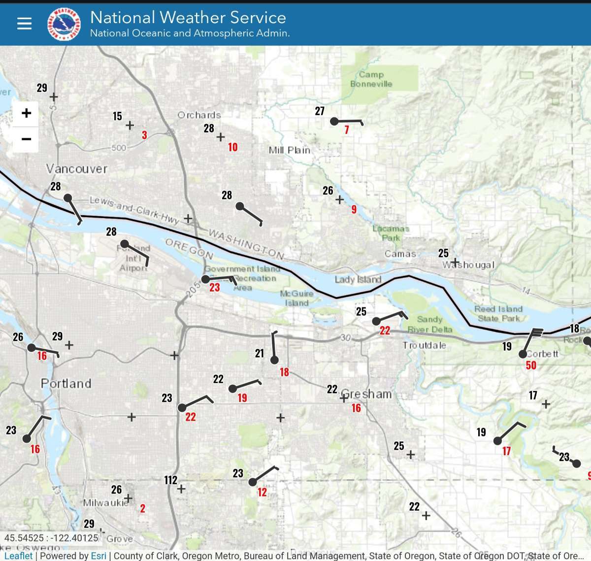
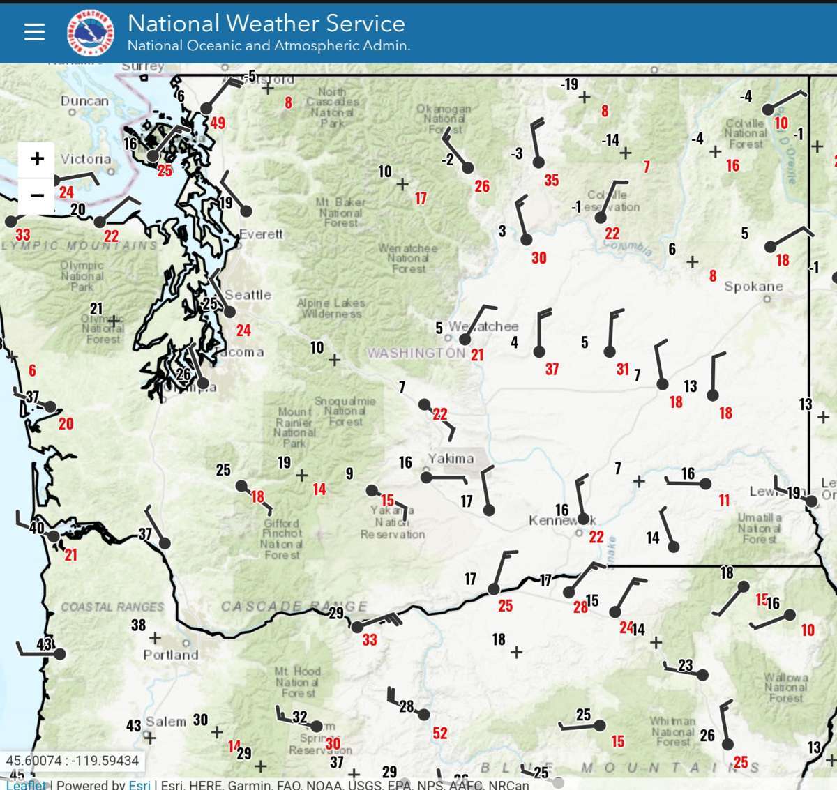
I woke up around 1:30am (I think) and looked at this map. I wanted to find out where the cold air is. At that time, The Dalles was 39° degrees....it's now 29 with a NE wind. Look at some of the temperatures. A lot are in the single digits but a few a way below zero. The cold air has arrived and soon those East winds are coming. It's going to be brutally cold
🌨

-
1
-
1
-
2
-
-
2 minutes ago, Weiner Warrior said:
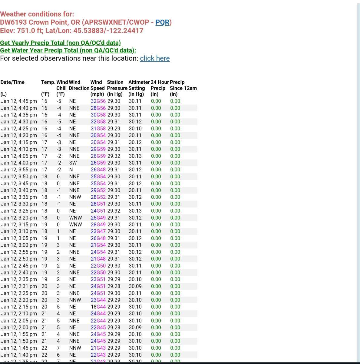
I don't think the model knows how thick the cold air will be. Remember, the East Winds will be screaming through the Gorge. Models are showing gusts up to 60 mph at Troutdale and probably up to 100+ at Crown Point.
-
5
-
-
I think you can see the cold air pushing between BC and Washington
-
4
-
-
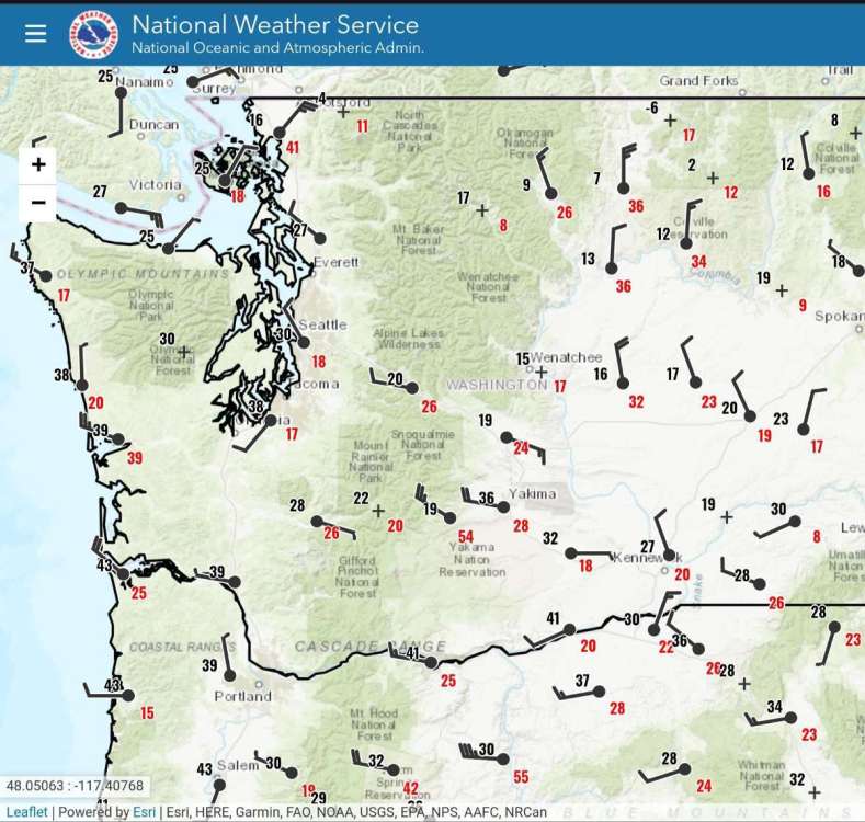
Temperatures on the Eastside of Washington are in the teens and single digits and one is below zero
-
6
-
1
-


.gif.85608b0bd17802abe064baa93f5c0476.gif)


January 2024 Weather in the PNW (Part II)
in West of the Rockies
Posted
The shield of moisture is getting larger down South and it's moving North


