the_convergence_zone
-
Posts
1241 -
Joined
-
Last visited
-
Days Won
2
Everything posted by the_convergence_zone
-
March 2024 Weather in the PNW
the_convergence_zone replied to TigerWoodsLibido's topic in West of the Rockies
I can see why some folks take a break from this forum between roughly March and October. (love you all, but it's going to be a long time until we have a snow threat again...) -
March 2024 Weather in the PNW
the_convergence_zone replied to TigerWoodsLibido's topic in West of the Rockies
Got back early this morning. Amazing how much it greened up since last Thursday. And one of my artichokes came up! I thought the Jan cold snap finished them off. -
March 2024 Weather in the PNW
the_convergence_zone replied to TigerWoodsLibido's topic in West of the Rockies
76/69 on Kauai today with the trades cranking. Looked like a nice day back home…decent storm coming through mid-week and then another pleasant weekend to close out March. I love when the storms avoid the weekends. -
March 2024 Weather in the PNW
the_convergence_zone replied to TigerWoodsLibido's topic in West of the Rockies
I think that's because the bacteria in the soil that produce the petrichor are more widespread in the summer. The fun part is when you can smell it before the rain actually starts, presumably because of outflow winds from the incoming rain. -
March 2024 Weather in the PNW
the_convergence_zone replied to TigerWoodsLibido's topic in West of the Rockies
Nice to catch a bit of sunshine today. All of this green will look good with a soaking rain. -
March 2024 Weather in the PNW
the_convergence_zone replied to TigerWoodsLibido's topic in West of the Rockies
I don't want to rehash an earlier conversation but I agree that the dice are loaded against us right now, but there is plenty that can happen between now and July that could reduce wildfire danger or set the stage for a below average wildfire year. If you have property in a wildfire danger area, you should probably be concerned about every single year going forward. -
March 2024 Weather in the PNW
the_convergence_zone replied to TigerWoodsLibido's topic in West of the Rockies
Too early to worry about wildfire smoke IMO. The smoke from last year's Canadian fires didn't bother us much. The sources were too far NE of us. -
March 2024 Weather in the PNW
the_convergence_zone replied to TigerWoodsLibido's topic in West of the Rockies
Pretty much normal around here. Some -10F anomalies in areas that have been running a +10F anomaly for 3-4+ months.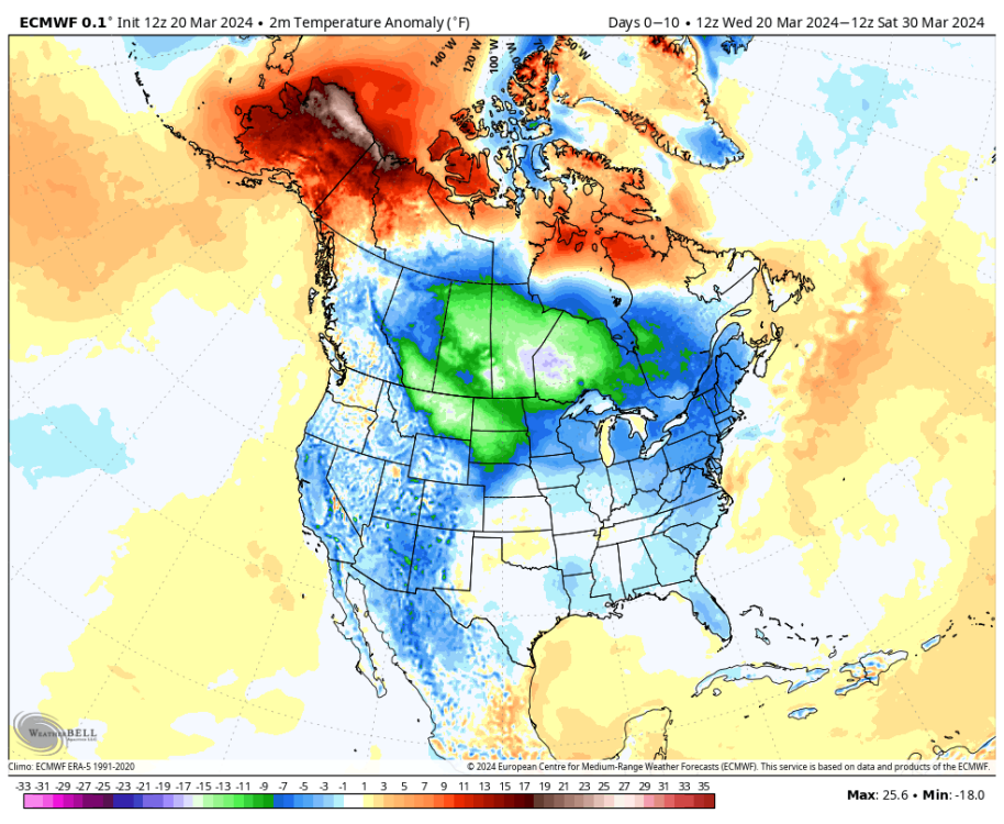
-
March 2024 Weather in the PNW
the_convergence_zone replied to TigerWoodsLibido's topic in West of the Rockies
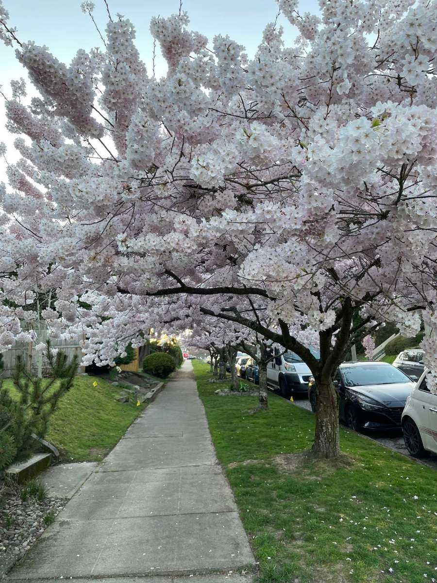
I have no idea what variety they are. There is a different variety across the street that looks similar but blooms about 10 days later. -
March 2024 Weather in the PNW
the_convergence_zone replied to TigerWoodsLibido's topic in West of the Rockies
Saw these on my evening walk. A gust of wind caused so much pollen to come off a juniper hedge that it looked like smoke.
-
March 2024 Weather in the PNW
the_convergence_zone replied to TigerWoodsLibido's topic in West of the Rockies
I experienced a couple of storms like that in Wisconsin although there's not enough moisture to go much above about 20" in one storm. We had a few in the 15-20" range with frequent lightning and wicked deformation zones. The blizzard of 1999 was always the top one for me but it happened to work out that when I was in the atmospheric science program in Madison there were a couple of really epic storms during the winter where Madison broke 100" of snow in a season for the first time on record ('07-'08). At that time, the university hadn't closed for snow since the early 1990s, so they took it as a point of pride to keep the streak going and stay open for some really nasty storms. I remember once we trudged to class in the afternoon near the end of a 14" storm (although as met students we would have been there anyway to track the storm). They made it through the entire 100 inch winter without a closure, but then there was finally a huge storm in December 2009 with 18"+ forecasts that forced their hand. And they called the closure the night before, just as the snow was beginning to fall, so it resulted in a gigantic party. Good times! -
March 2024 Weather in the PNW
the_convergence_zone replied to TigerWoodsLibido's topic in West of the Rockies
It's almost always too warm for snow there except when there is an approaching warm front with cold air available on the east side of the Cascades. Which describes at least half of our winter weather systems. So it dumps feet of snow there with the snow level sitting at 2950 ft at the ski resort and 4500 ft just about everywhere else in the Cascades. The crazy thing is that Snoqualmie actually had better early season coverage than Crystal and Mt. Baker this year because picked up a few feet from their microclimate in early December while everyone else was seeing rain. And a high of 40 with December "sun" doesn't melt anything. I was up there around Christmas and it looked much better than I was expecting. The projections continue to indicate that there are about 20 years of skiing left at Snoqualmie before it gets too warm, but so far the 2014-15 winter was the only one where they didn't get enough snow to have a full season. -
March 2024 Weather in the PNW
the_convergence_zone replied to TigerWoodsLibido's topic in West of the Rockies
Add it to the list of things that used to have 10-15 year return intervals but is now 3-5 years. -
March 2024 Weather in the PNW
the_convergence_zone replied to TigerWoodsLibido's topic in West of the Rockies
It sounds like we’re in agreement that these statements were not made by mainstream climate scientists (whose views are well represented in the IPCC reports) but rather by “experts” who are known for making splashy quotes that the media eats up. -
March 2024 Weather in the PNW
the_convergence_zone replied to TigerWoodsLibido's topic in West of the Rockies
Quillayute is an interesting site. That 110 record is perhaps the most extreme daily temperature record of any station anywhere in the entire world. There is something about that location that has made it more prone to downslope warming events in recent years. It’s an oddity. -
March 2024 Weather in the PNW
the_convergence_zone replied to TigerWoodsLibido's topic in West of the Rockies
I would hope that the collective weather and climate knowledge of this forum puts us above using news headlines to form opinions about climate change. If we did that for regular weather events we would probably lose our minds…how many terms like “bomb cyclone”, “polar vortex”, etc have been butchered by the media over the years? -
March 2024 Weather in the PNW
the_convergence_zone replied to TigerWoodsLibido's topic in West of the Rockies
It’s not a mainstream opinion in the climate science community. -
March 2024 Weather in the PNW
the_convergence_zone replied to TigerWoodsLibido's topic in West of the Rockies
Who is “they”? -
March 2024 Weather in the PNW
the_convergence_zone replied to TigerWoodsLibido's topic in West of the Rockies
Quillayute isn’t in the Puget Sound and they have never seen an 80 in March until today. Even 70 is an extreme rarity this early in the year, they doubled their count of 70+ prior to St Patrick’s day in the past 2 days. -
March 2024 Weather in the PNW
the_convergence_zone replied to TigerWoodsLibido's topic in West of the Rockies
73/45 here. It was a little warm for my liking in the afternoon. I had to find some shade. It’s pretty much a given that a ridge equals record highs these days. -
March 2024 Weather in the PNW
the_convergence_zone replied to TigerWoodsLibido's topic in West of the Rockies
57/42 here today. Not particularly warm but the midday sun was awesome. -
March 2024 Weather in the PNW
the_convergence_zone replied to TigerWoodsLibido's topic in West of the Rockies
The fun of Colorado is that entire snowpack can be erased in about 24 hours if the winds are right. -
March 2024 Weather in the PNW
the_convergence_zone replied to TigerWoodsLibido's topic in West of the Rockies
I've hit 57 so far. My station is near the 56 in West Seattle. Pretty common for me to be one of the colder spots on a day like this, I need that wind to swing around to the east for me to get warm. -
March 2024 Weather in the PNW
the_convergence_zone replied to TigerWoodsLibido's topic in West of the Rockies
Yep, basically every fruit grower in central/eastern Washington is on edge this time of year. A cold snap after a warm spell can be disastrous. -
March 2024 Weather in the PNW
the_convergence_zone replied to TigerWoodsLibido's topic in West of the Rockies
Fortunately the absurd current global SST anomalies probably have a big natural variability component that is dominating over some of the other Tonga/ship aerosol theories, but it's still bad when the SSTs in the Atlantic MDR are already at their June normals in March.