the_convergence_zone
-
Posts
1273 -
Joined
-
Last visited
-
Days Won
2
Everything posted by the_convergence_zone
-
July 2023 PNW Observations and Discussions
the_convergence_zone replied to Timmy Supercell's topic in West of the Rockies
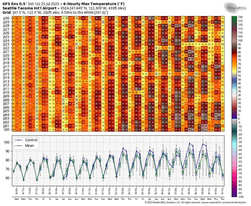
The first weekend in August looks locked in for a warm period. Probably doesn’t qualify as a true heat wave although KSEA will surely find a way to hit 90 or 91. I’m amazed at how good the model consensus is, even the GEFS isn’t all that different from the Euro although slightly warmer. Euro ensembles are in beautiful lockstep.
-
July 2023 PNW Observations and Discussions
the_convergence_zone replied to Timmy Supercell's topic in West of the Rockies
I see that GFS run has a fantasy hurricane to go along with its fantasy heatwave. Truly checking all of the boxes. -
July 2023 PNW Observations and Discussions
the_convergence_zone replied to Timmy Supercell's topic in West of the Rockies
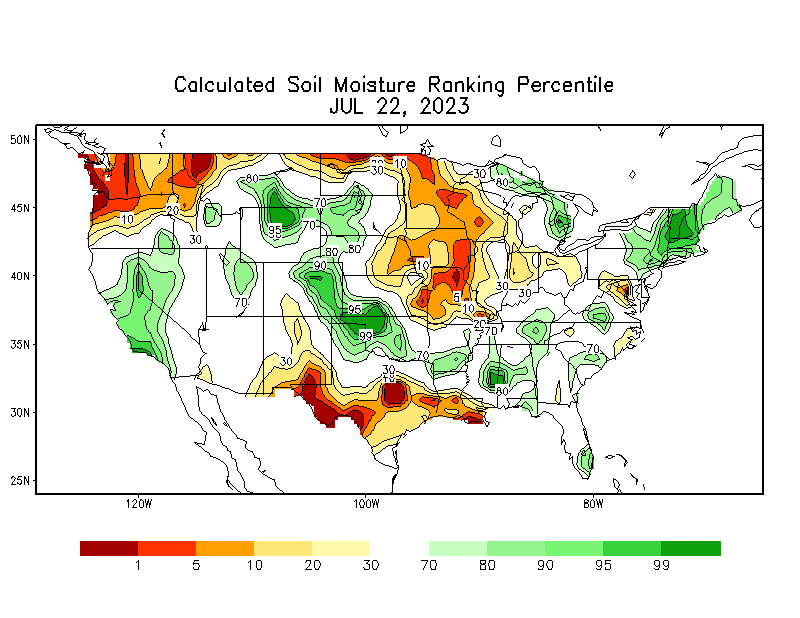
I didn't realize how badly BLI is running below normal on precip this year. Only 8.89" on the year after yesterday, around 50% of normal. That stat about it being the wettest day of the year is also incredible.- 3487 replies
-
- 3
-

-
- summer 2023
- july
- (and 1 more)
-
July 2023 PNW Observations and Discussions
the_convergence_zone replied to Timmy Supercell's topic in West of the Rockies
Blue sky overhead. 0.05” is my final total. Looks like 0.08” is the official tally at the airport.- 3487 replies
-
- 1
-

-
- summer 2023
- july
- (and 1 more)
-
July 2023 PNW Observations and Discussions
the_convergence_zone replied to Timmy Supercell's topic in West of the Rockies
Not enough forcing south of I-90. I was hoping a shower would drop a quick tenth or two but it wasn't in the cards. I expected it but I'm still disappointed. Great to see all that rain to our north and west, it was desperately needed.- 3487 replies
-
- 3
-
-
- summer 2023
- july
- (and 1 more)
-
July 2023 PNW Observations and Discussions
the_convergence_zone replied to Timmy Supercell's topic in West of the Rockies
Ugh. All of those one-run wins in 2021 and 2022 are evening out. I’m up to 0.04” as another shower scoots just to my south.- 3487 replies
-
- 1
-
-
- summer 2023
- july
- (and 1 more)
-
July 2023 PNW Observations and Discussions
the_convergence_zone replied to Timmy Supercell's topic in West of the Rockies
So far I have managed to dodge every single shower. It has barely rained here.- 3487 replies
-
- 2
-
-
- summer 2023
- july
- (and 1 more)
-
July 2023 PNW Observations and Discussions
the_convergence_zone replied to Timmy Supercell's topic in West of the Rockies
Kolten Wong did a thing!!- 3487 replies
-
- 1
-
-
- summer 2023
- july
- (and 1 more)
-
July 2023 PNW Observations and Discussions
the_convergence_zone replied to Timmy Supercell's topic in West of the Rockies
Doubled my rainfall from this morning, 0.02” storm total.- 3487 replies
-
- 1
-
-
- summer 2023
- july
- (and 1 more)
-
July 2023 PNW Observations and Discussions
the_convergence_zone replied to Timmy Supercell's topic in West of the Rockies
By your logic there isn't a single surface temperature station on earth that should be considered reliable except maybe in Antarctica.- 3487 replies
-
- 1
-
-
- summer 2023
- july
- (and 1 more)
-
July 2023 PNW Observations and Discussions
the_convergence_zone replied to Timmy Supercell's topic in West of the Rockies
According to the HRRR I'll get another 0.01" to add to the 0.01" that I got this morning. But it does look like there will be some embedded heavier showers in that band so there will be some winners. Need to get the sun out today to build up the surface CAPE before that secondary line moves in. Getting up to 75 F would be ideal. -
July 2023 PNW Observations and Discussions
the_convergence_zone replied to Timmy Supercell's topic in West of the Rockies
Do you pay by volume for water? I was shocked the first time I was in Tri-Cities in the summer and there was green grass everywhere. Nobody waters their lawns in Seattle unless they want a $500 water bill. -
July 2023 PNW Observations and Discussions
the_convergence_zone replied to Timmy Supercell's topic in West of the Rockies
Officially measurable rain, 0.01! Looks like this front had a rough time with the dry air over Puget Sound, I don't think I'm going to get more than a few hundreths with this initial line. Maybe more this evening...- 3487 replies
-
- 1
-
-
- summer 2023
- july
- (and 1 more)
-
July 2023 PNW Observations and Discussions
the_convergence_zone replied to Timmy Supercell's topic in West of the Rockies
I’ll be happy with a tenth. The first storm after an extended dry period is almost always an underperformer and the central sound is going to be somewhat rain shadowed. -
July 2023 PNW Observations and Discussions
the_convergence_zone replied to Timmy Supercell's topic in West of the Rockies
Copper Ridge is awesome! Did that as a trail run in October 2018, one of my favorite days of all time.- 3487 replies
-
- 1
-
-
- summer 2023
- july
- (and 1 more)
-
July 2023 PNW Observations and Discussions
the_convergence_zone replied to Timmy Supercell's topic in West of the Rockies
-
July 2023 PNW Observations and Discussions
the_convergence_zone replied to Timmy Supercell's topic in West of the Rockies
Monday’s daily rainfall record at Sea-Tac is one of the easiest ones to break, 0.28”. It might actually have a chance of falling. The ensemble mean is up to 0.20” or so. -
July 2023 PNW Observations and Discussions
the_convergence_zone replied to Timmy Supercell's topic in West of the Rockies
Great game! They haven’t been winning games like that this year, maybe this will finally get them going in the right direction. Or they will be .500 again after losing tomorrow.- 3487 replies
-
- 2
-
-
- summer 2023
- july
- (and 1 more)
-
July 2023 PNW Observations and Discussions
the_convergence_zone replied to Timmy Supercell's topic in West of the Rockies
That anomaly map is relative to the 1991-2020 normal, so it really shouldn't be used in any debate about climate change... But your point does stand, the climate system is complex and it's very hard for the average person who doesn't obsess about the weather to contextualize what a 1-1.5 degree C increase means for their day-to-day life. Some of the activists have gotten where they are with sensationalist messaging, which unfortunately is often not based in reality and tends to do more harm than good. Some scientists respond by educating and clarifying, others respond with sarcastic tweets and easy dunks. It's tough to message, especially when nobody really knows how much of "record-breaking temperatures on every continent" can be attributed to ENSO, Tonga, shipping aerosols, other natural variability, climate change, etc. -
July 2023 PNW Observations and Discussions
the_convergence_zone replied to Timmy Supercell's topic in West of the Rockies
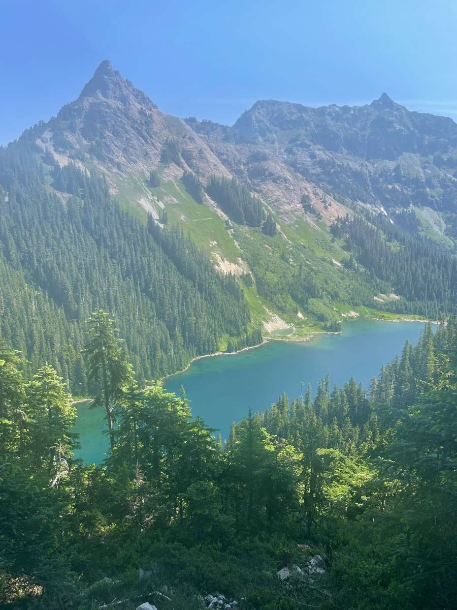
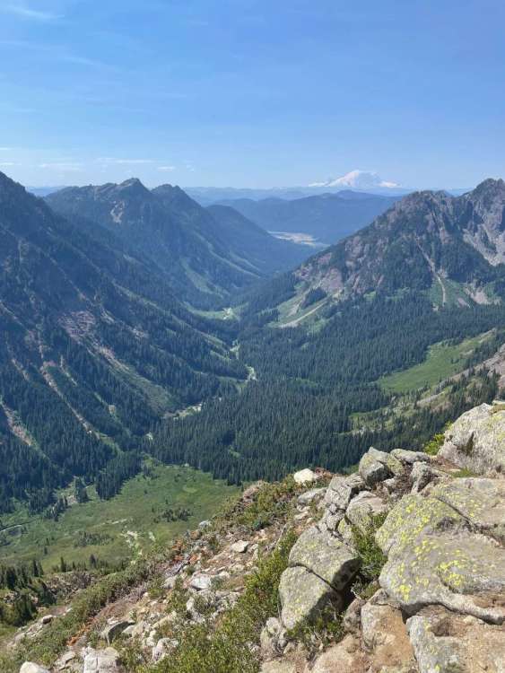
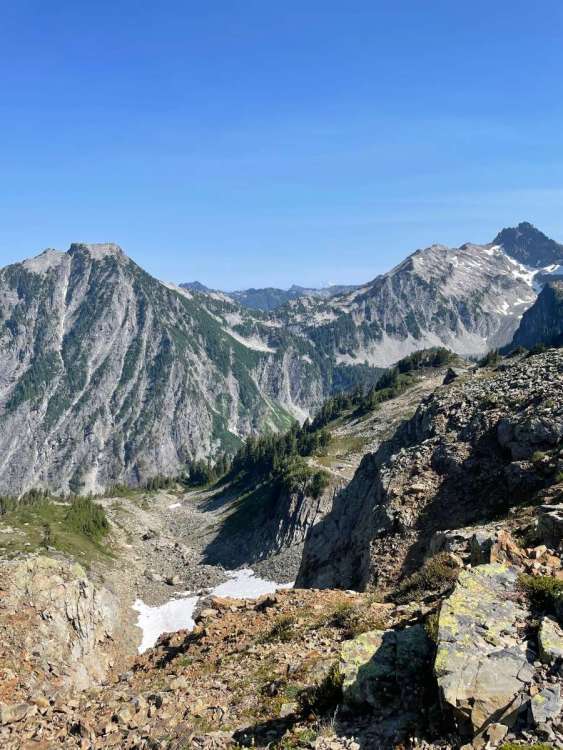
Here’s pics from the PCT north of Snoqualmie Pass yesterday. First time I have gotten up to the high country this year. It was HOT yesterday and it’s bone dry up there. Snow is a distant memory. Rain desperately needed. It was 84 F at the pass when I got back down around 2:00.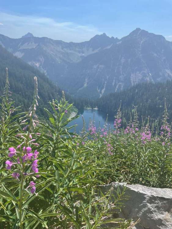

- 3487 replies
-
- 9
-
-
- summer 2023
- july
- (and 1 more)
-
July 2023 PNW Observations and Discussions
the_convergence_zone replied to Timmy Supercell's topic in West of the Rockies
Happy birthday!!!! -
July 2023 PNW Observations and Discussions
the_convergence_zone replied to Timmy Supercell's topic in West of the Rockies
Maybe a quarter of ens members think this will amount to something in Seattle. Around half have more than a tenth in Bellingham. Looks like a zero in Seattle to me, that rain shadow will never fill in this time of year.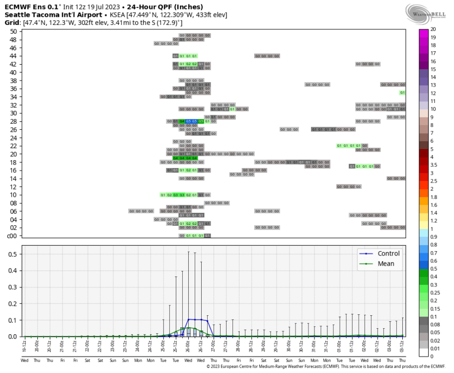

-
July 2023 PNW Observations and Discussions
the_convergence_zone replied to Timmy Supercell's topic in West of the Rockies
I only hit 84 today but the uptick in humidity is especially noticeable -
July 2023 PNW Observations and Discussions
the_convergence_zone replied to Timmy Supercell's topic in West of the Rockies
I had to look this up a bit more and it appears ENSO forces the PDO by modulating the strength of the Aleutian low which then affects the Kuroshio current. So the current -PDO state is at least in part a response to the triple-dip La Niña. https://www.climate.gov/news-features/blogs/enso/going-out-ice-cream-first-date-pacific-decadal-oscillation- 3487 replies
-
- 1
-
-
- summer 2023
- july
- (and 1 more)
-
July 2023 PNW Observations and Discussions
the_convergence_zone replied to Timmy Supercell's topic in West of the Rockies
Why? The 1.6 million people who live in Phoenix experienced it as the warmest morning on record.