the_convergence_zone
-
Posts
1273 -
Joined
-
Last visited
-
Days Won
2
Everything posted by the_convergence_zone
-
February 2024 Weather in the PNW
the_convergence_zone replied to TigerWoodsLibido's topic in West of the Rockies
They get NCFRs in the Midwest sometimes as well. It’s a sub-type of cold fronts. The dynamics that form the little cells in the band are really interesting (and complicated, it’s a form of shear instability) and are almost always embedded in a broader stratified rainband. -
February 2024 Weather in the PNW
the_convergence_zone replied to TigerWoodsLibido's topic in West of the Rockies
It looks like a textbook NCFR to me. -
February 2024 Weather in the PNW
the_convergence_zone replied to TigerWoodsLibido's topic in West of the Rockies
I just hit 3 inches of rain for the month LOL -
February 2024 Weather in the PNW
the_convergence_zone replied to TigerWoodsLibido's topic in West of the Rockies
They are more interesting on the coast. Once they get butchered by terrain they are barely noticeable. -
February 2024 Weather in the PNW
the_convergence_zone replied to TigerWoodsLibido's topic in West of the Rockies
Typical +ENSO pattern for the most part, except the areas that are doing bad are doing really bad. -
February 2024 Weather in the PNW
the_convergence_zone replied to TigerWoodsLibido's topic in West of the Rockies
Just saw a post from an Olympic NP scientist that their snow survey at Deer Park was the 3rd lowest in 76 years, ahead of only 2005 and 2015. Just 1.5 inches of liquid equivalent. -
February 2024 Weather in the PNW
the_convergence_zone replied to TigerWoodsLibido's topic in West of the Rockies
I tend to agree that there will be no widespread accumulations below 500'. I think some areas above 500' are likely to get accumulations on grassy surfaces. I do think some lucky spot below 500' will see at least some snowflakes, but given the showery nature of the precipitation, it's a quick coating and melt within an hour or two situation. And certainly no snow below 1000' between the hours of 10 am and 5 pm. -
February 2024 Weather in the PNW
the_convergence_zone replied to TigerWoodsLibido's topic in West of the Rockies
The snow line was halfway up Alpental on Sunday as well. Huge accumulations above 4,000 ft. The Olallie Meadows SNOTEL near Mt. Catherine might hit normal by the end of this cold period. The Olympics and anything below 3,500 ft is in rough shape, but this weekend will help. Should get most sites of the bottom 5 at least. -
February 2024 Weather in the PNW
the_convergence_zone replied to TigerWoodsLibido's topic in West of the Rockies
11 PM - midnight or so according to the HRRR. Now that they flipped to rain they have to wait for the cold front passage to flip back. Still progged to get nearly a foot by early tomorrow though. -
February 2024 Weather in the PNW
the_convergence_zone replied to TigerWoodsLibido's topic in West of the Rockies
I stepped through the 1-h ECMWF precip type plots and there was not a single timestep with snow over downtown Seattle. It was either rain or dry. The temperature does not drop below 36-37 degrees. Despite that, the model is showing several inches of snow with the Kuchera ratio. -
February 2024 Weather in the PNW
the_convergence_zone replied to TigerWoodsLibido's topic in West of the Rockies
I don't know if it's still true, but at one point the bonus payouts at ECMWF were based on how far ahead of the GFS they were. -
February 2024 Weather in the PNW
the_convergence_zone replied to TigerWoodsLibido's topic in West of the Rockies
Yeah they all know the biases and correct accordingly. Snow maps are a relatively new phenomenon anyway and most in the professional community avoid them like the plague. There's a reason why the model data providers don't provide them -- they are created by the map websites. 10:1 map = QPF * (% snow) * 10. So if you have 1 inch of QPF and it's a perfect mix of 50% rain and 50% snow, the 10:1 map will give you 5 inches of snow. -
February 2024 Weather in the PNW
the_convergence_zone replied to TigerWoodsLibido's topic in West of the Rockies
12Z Euro snow depth change is better, but still looks too high.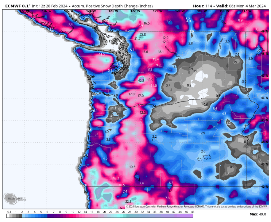
-
February 2024 Weather in the PNW
the_convergence_zone replied to TigerWoodsLibido's topic in West of the Rockies
To be fair, the UW-WRF also has big numbers close to the coast. I don't know what it is about the HRRR that makes it so much better than other models at estimating the snow level in these marginal events. I've been watching it the past few days and it keeps getting the rain changeovers at Snoqualmie Pass correct, whereas pretty much everything else is swinging and missing. Once we have the RRFS ensemble we may just be able to ignore everything else, assuming they tune that one the same as the HRRR (which I have low confidence in, but we can hope...). -
February 2024 Weather in the PNW
the_convergence_zone replied to TigerWoodsLibido's topic in West of the Rockies
The advantage to this pattern is the abundant moisture, the disadvantages are the lack of truly cold near-surface air in a southwesterly onshore flow regime and a lack of any widespread organized precipitation until early next week. Past experience suggests that snow will pile up in the mountains above 2,000 ft, below that it's going to be patchy. If I had to guess, I think Sea-Tac gets an inch or two either Friday or Saturday AM (or both) and avoids the dreaded zero snow winter. Downtown Seattle probably stays all rain (or mix in any heavier showers) unless one of those little baby vortices happens to take the right track (Sat AM perhaps). -
February 2024 Weather in the PNW
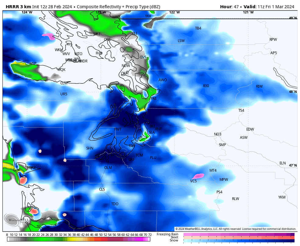
the_convergence_zone replied to TigerWoodsLibido's topic in West of the Rockies
12Z HRRR goes brrrrr on Friday morning
- 8823 replies
-
- 11
-

-

-

-
February 2024 Weather in the PNW
the_convergence_zone replied to TigerWoodsLibido's topic in West of the Rockies
It’s too bad the Euro doesn’t agree with the UW-WRF on that beautiful low track with an Astoria landfall. Friday AM seems like a safer bet for snowfall down to sea level in the Seattle area. I’m getting excited but it could still all blow up and be a nothing burger for me. Lots of folks on here should score something though. -
February 2024 Weather in the PNW
the_convergence_zone replied to TigerWoodsLibido's topic in West of the Rockies
Now that’s a goldilocks setup if I ever saw one.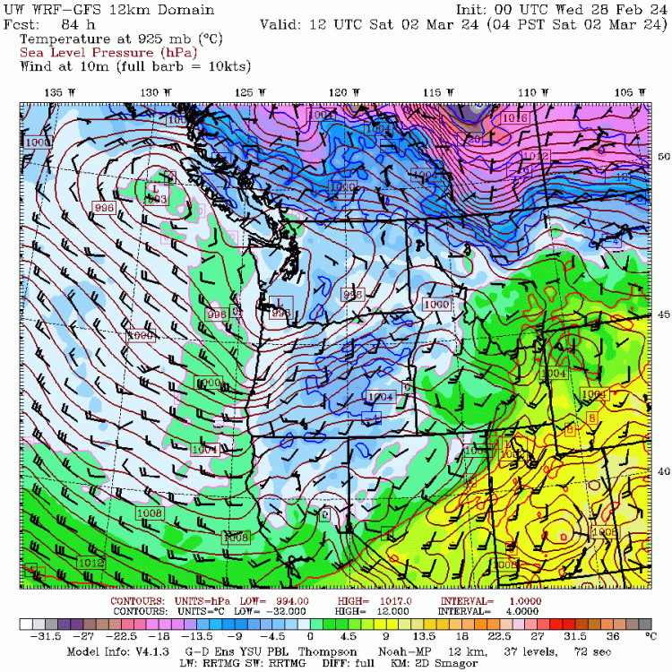
-
February 2024 Weather in the PNW
the_convergence_zone replied to TigerWoodsLibido's topic in West of the Rockies
Yeah it’s never going to be 10:1 when the temperature is 32 or above. Maybe close if it holds at exactly 32 with rapid snow rates and there isn’t much aggregation. Rain gauges undercatch snow so I would suspect a measurement error if someone observed 10:1 at those temperatures. The biggest inaccuracies with Kuchera are actually at high snow ratios in the 10-20:1 range because of wind and different crystal habits that accumulate in different ways. I’ve seen ratios as high as 40:1 when there are pristine dendrites and no wind. -
February 2024 Weather in the PNW
the_convergence_zone replied to TigerWoodsLibido's topic in West of the Rockies
That's the key question -- there's clearly some component driven by the Phil stuff -- global circulation response to climate forcing like the Hadley expansion. We already have a persistent ridge over the Rocky Mountains in summer (instead of an anomaly plot, just plot up the climatological mean 500 hPa heights), so the anomaly plots from the last 10 years are showing the amplification of a feature that's already there. It's not like ridging is being created out of thin air, there was already a climatological ridge there. And I would postulate that the moisture component is accelerating that because it is further amplifying the temperature and pressure differences between the ocean and mountains because the land is warming faster than the ocean and the land is drying out in our region in summer. So I would argue the unique aspects of our topography are already responsible for our dry summers and that whole pattern is just being amplified by climate change. And thus there isn't a reason to expect that big height anomaly blob to move in the future, the last 10 years are likely an indication of what to continue to expect moving forward. -
February 2024 Weather in the PNW
the_convergence_zone replied to TigerWoodsLibido's topic in West of the Rockies
The key question for future decades is the extent to which the Clausius-Clapeyron moisture feedbacks are influencing this pattern. Saturation vapor pressure is increasing at 7% per deg C but RH tries to stay constant so the atmosphere is driving a s*** ton of spring and summertime evapotranspiration that wasn't happening before. -
February 2024 Weather in the PNW
the_convergence_zone replied to TigerWoodsLibido's topic in West of the Rockies
Yeah, as of two weeks ago February is considered tornado season in Wisconsin. Now that there's been one the floodgates can open up. -
February 2024 Weather in the PNW
the_convergence_zone replied to TigerWoodsLibido's topic in West of the Rockies
I just ran these numbers recently...comparing last 10 years to the previous 40 years...yes, basically no change in winter temperatures, maybe 0.1 or 0.2 C warming at most vs. ~1970-2010 depending on what baseline period you use. Spring is about 1.0 C warmer in the last 10 years, fall 1.5 C warmer, and summer is around 1.8 or 1.9 C warmer. That's based off of 850 hPa temperatures at KUIL, so that does not include local or urban effects. So over the full year it averages out similar to the ~1 C of warming that the planet has experienced over that period...but the seasonal differences in this region are nuts. I haven't crunched the numbers yet for OTX or SLE but have been meaning to. I do think the winter temps have been held in check by -ENSO this century. If we have a run of neutral or +ENSO winters then the warming will show up in the stats. -
February 2024 Weather in the PNW
the_convergence_zone replied to TigerWoodsLibido's topic in West of the Rockies
The 12Z HRRR has the snow level getting down to about 500' in the north Sound early Thurs morning. It's dynamic cooling due to strong precip rates combined with diurnal min. -
February 2024 Weather in the PNW
the_convergence_zone replied to TigerWoodsLibido's topic in West of the Rockies
About as likely as Seattle getting 4" of snow in a fully onshore flow regime LOL.