

Reg
-
Posts
2312 -
Joined
-
Last visited
-
Days Won
1
Posts posted by Reg
-
-
Nice photos.
Some considerable wind picking up here now. Loud.
-
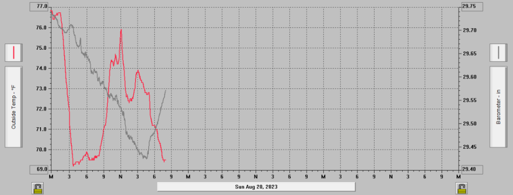
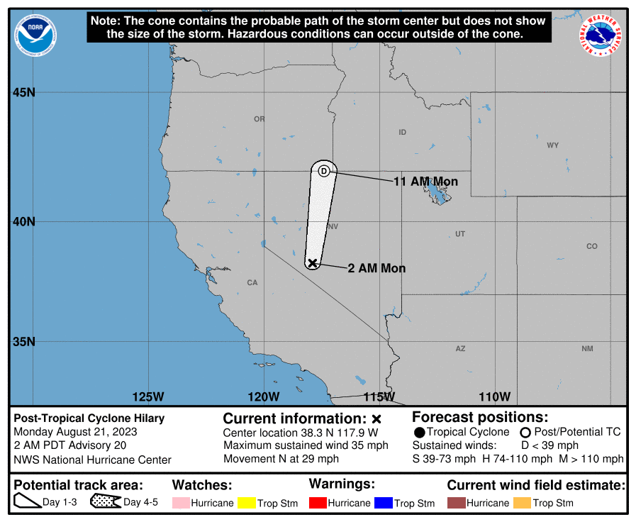
What was left of the eye of Hilary passed only about 20 miles east of me around 5 PM. That was when my barometer displayed its lowest reading - 29.43" - before going back up.
-
-
A lot more wind than rain here at the moment. Looks very dark and eerie outside.
-
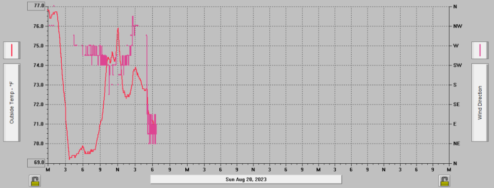
Wind direction shifted here about two hours ago.
-
Lot of wind over the past couple hours. Rain has mostly died out for now.
Clouds are really moving fast. 1.77" for today.
-
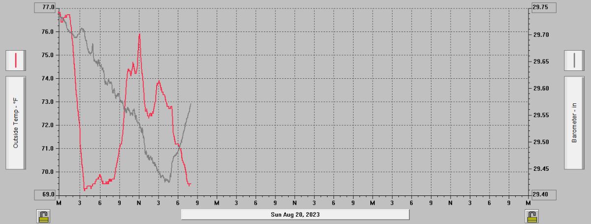
Rain and wind have oddly calmed down here over the past hour. 0.43" since midnight. Barometer has plunged to 29.56". Current temperature 74F and holding. Cloudy.
-
Lot of wind here right now.
Even as a tropical storm, Hilary's convective bands remain a significant threat to us.
-
13 minutes ago, Front Ranger said:
Hurricane Hilary is no more. Downgraded to a tropical storm, with max winds of 70 mph.
By the time it reaches CA, the winds should be pretty weak.
Maybe. The tornado threat over my area remains at large, however.
8 minutes ago, Anti Marine Layer said:The eye should hit San Diego County around 3 PM today
Probably earlier than that
-
Winds are acting up here. 20mph gusts at the moment. 0.41" since midnight.
-
Wind is acting strange and erratic here. I'm worried that the plywood above my window air-conditioner is going to be destroyed if winds kick up significantly.
-
26 minutes ago, IMoveALot_Weather said:
We get worse winds every year during Santa Ana events, I'm not worried about it. Especially with the Eastward jog of the track. I grew up in hurricane country, I'd be surprised if we even got tropical storm force GUSTS, let alone sustained winds.
My location in Murrieta is not prone to gusty winds at all, since 2014 the highest gust I've recorded was only 41 MPH. This event could be higher for me.
Granted, the weather stations in Riverside that I've serviced were all very wind-prone. You guys in Riverside are far more prone to typical Santa Anas than me.
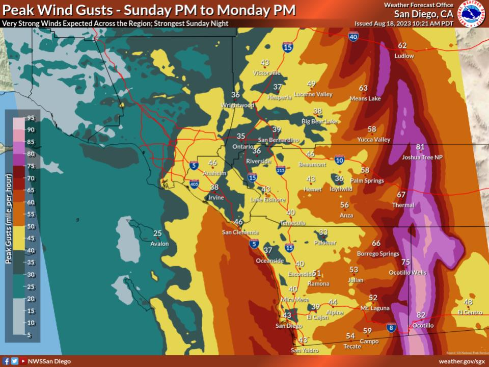
Remember, late this morning through this afternoon are when the greatest impacts from Hilary are expected to hit us.
-
Rain and wind have both suddenly stopped. 0.37"
-
4 minutes ago, IMoveALot_Weather said:
It's been pretty consistent light rain for the past few hours here. I do think this will just be a routine rain event here.
I'm more concerned about potential damaging winds rather than rain here. That applies to your area as well as you're not that far north of me.
-
29 minutes ago, Thunder98 said:
Theres a very good chance that I will not see a single drop of rain. Such bs
Sorry, but at least you're not in danger like some of us.
Wind just started to kick up here. Still raining steadily. 0.30" since midnight.
-
Barometer is falling. 0.01" so far.
-
-
-
7 hours ago, IMoveALot_Weather said:
He was being sarcastic, it was a snarky reply towards someone else who claimed that we're going to get shafted on this. I don't see why taking such big offense towards a post you disagree with is necessary, but I am not going to let a weather forum post live rent-free in my head like they do to him apparently.
Honestly, the shift east in track, combined with the speed of the storm does seem like it will equal less rain than initially indicated. Still don't see the lack of moisture that the other guy (the one who SpaceRace was mocking) was talking about anywhere in the picture.
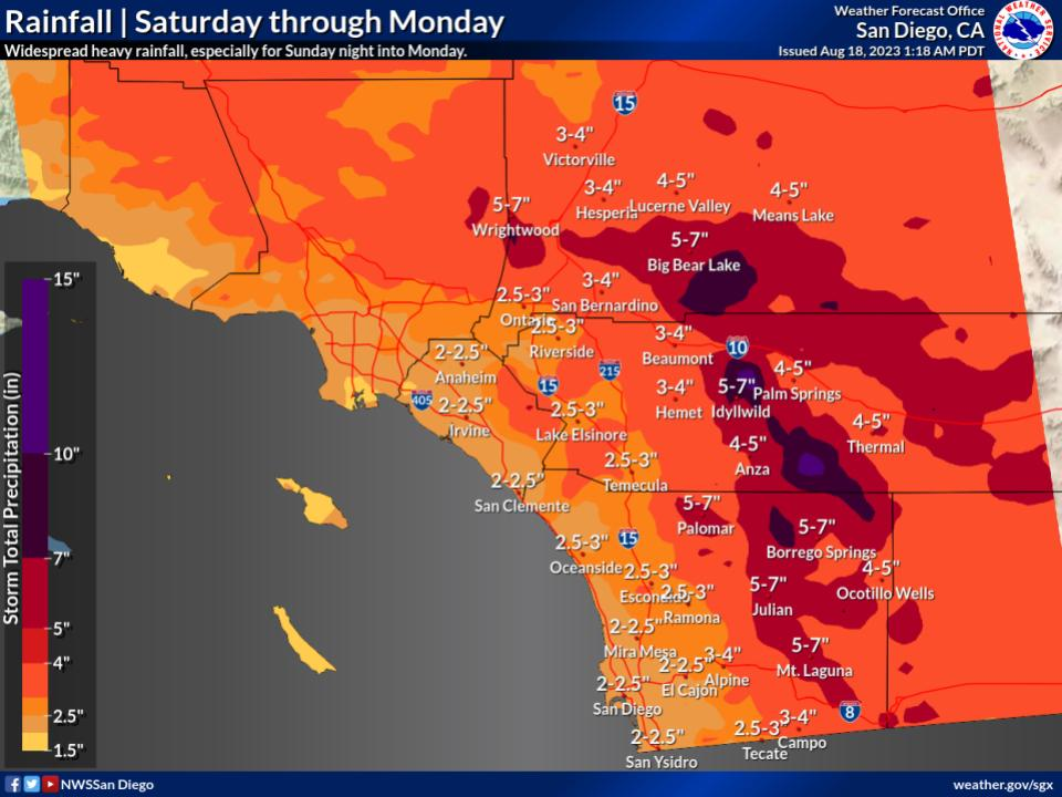
If anything, NWS actually bumped up both projected rainfall totals and peak wind gusts for us.
Cloudy here now.
-
1 hour ago, Anti Marine Layer said:
We'll see what happens with Hilary. Meanwhile there's a #$@!ing mosquito in my room this morning making a high pitched buzz.
Welcome to my world. I had to buy a special spray and heavily bomb every room in my house with it to keep mosquitoes away, and it works. Mosquitoes that try to come in all drop dead onto the floor.
1 hour ago, Thunder98 said:Now it looks like I will see very little rain now

RIP
17 minutes ago, IMoveALot_Weather said:You're still on this?
He is very confident, I've been avoiding the subject since I'm not exactly 100% sure myself. But things are looking very much like we're going to take a nasty hit no matter what...only you and I are the only ones on here who look like we're going to get hit by the centerline of Hilary or get on Hilary's bad (east) side.
The fire stations near me are all giving out free sandbags in preparation for Hilary. I heard from relatives that they ran out yesterday, apparently everyone is grabbing them in droves. I'll see if I can pick up any sandbags today...
-
Sky is getting cloudier here this morning.
-
-
This has to be an error.
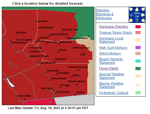
Edit: I see, the colors are very close but not the same. And the legend doesn't show our shade of dark red that is actually a Tropical Storm Warning, not a Hurricane Warning (that's south of the border offshore).
-
10 hours ago, IMoveALot_Weather said:
NAM keeps hurricane-force winds until just about the CA border.

NHC's 12pm advisory pretty much reflects the overall westward shift in the track
Ultimately, cold water is less damaging to a hurricane than dry land, so I would not be surprised to see this remain a hurricane until shortly before the border if this track holds. Strongest wind will still remain east of the center, over the desert.
Most current projections have the storm’s center going literally right over me in the Temecula Valley, which potentially means over you in Riverside as well.
.gif.073639723ca7bd9203a515cff6c6f152.gif)


2022-2023 California and Southwest Weather Thread
in West of the Rockies
Posted
Heavy rain and very windy. 2.03" for now.