


snow_wizard
-
Posts
41072 -
Joined
-
Last visited
-
Days Won
40
Posts posted by snow_wizard
-
-
1 hour ago, Doinko said:
Just had a heavy hail shower with some sun too! Went through quickly but it was pretty intense.
I had a good bout of hail here a couple of hours ago as well.
-
 2
2
-
-
Geeze. These ECMWF AI solutions are mouth watering.

-
3
-
 1
1
-
 1
1
-
 1
1
-
 1
1
-
-
2 hours ago, Timmy Supercell said:
My area will be alternating between tornadic storms and blizzards..


Maybe even a tornadic blizzard!
-
2
-
 3
3
-
 1
1
-
-
Just now, TT-SEA said:
Well we are 1/6th of the way through spring already... seems sort of obvious that winter is over.
I'm not sure what his point is here. We had a very cold starting March too.
-
2
-
-
Just now, MR.SNOWMIZER said:
We had some crazy weather at the cabin, Both days it would be sunny and 45 and then a storm would roll in, drop the temp to 30 and lay down 2 inches of snow with a bunch of wind. There is between 6-18 inches of snow up there.
Great climate up there. Even colder than Winthrop a lot of times.
-
4
-
-
2 hours ago, SilverFallsAndrew said:
Not a terrible way to start March.
And the fact it's going back into a nice GOA block later in the month after a quick spike.
#coldregime
-
1
-
 1
1
-
1
-
-
- Popular Post
- Popular Post
I wanna believe! Pretty much historic for late March.
-
3
-
 2
2
-
2
-
1
-
 1
1
-
1
-
1
-
2
-
1
-
1 hour ago, SilverFallsAndrew said:
I would love to move to the boreal forests of Siberia. Their politics suits me just fine.
I like Boreal forests though.
-
1
-
 1
1
-
-
2 hours ago, SnowWillarrive said:
PDX might hit 80
Mins in some places are going to remain pretty chilly during the warm weather and then we go right back to troughing again. Good stuff! No doubt the nice weekend is going to be enjoyable too.
-
1
-
-
1 hour ago, Slushy Inch said:
Too cold for much snow
Ya think a yearly mean of -67 might be just a tad too cold?

-
1
-
-
I am liking what I'm seeing right now. We're on a good roll.
-
1
-
-
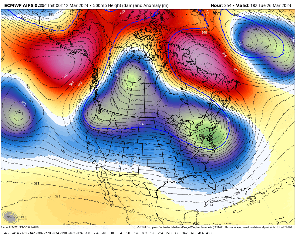
Incredibly the 18z ECMWF AI caved to the GFS. Pretty D**n crazy!
Looks like we have a shot at seeing some chilly continental air later in the month. Not easy to pull off here this late in the season. Might be an interesting average low this month for some places.
-
5
-
-
55 minutes ago, Sunriver Snow Zone said:
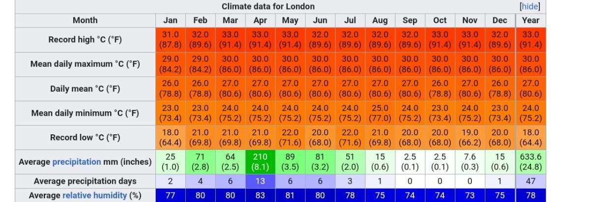
Found a climate even more consistent than da lat. London! (In kiribati, not the UK)

Talk about hell on Earth. Yikes!
-
2
-
-
1 hour ago, TT-SEA said:
GFS pretty consistent in retrograding the ridge by Tuesday. GEM went that direction as well. 3 or 4 warm days... pretty standard for March.
GFS might end up being right. Sometimes it does great with catching onto things in the longer range.
-
1 minute ago, SilverFallsAndrew said:
Looks pretty dry though either way.
Difficult to not be dry with high pressure dominating the NE Pacific.
-
1 hour ago, Cascadia_Wx said:
Phenology getting pushed 2-4 weeks ahead of schedule seems pretty bold, especially since as of right now everything seems to be at least several days behind, thanks to the late Feb/early March cool spell. I’d say this could stand to push things a week or so ahead of normal. Mild rain is probably the best at jump starting things. Warm afternoon temps with cool mornings and drier air is decent, but not quite as effective.
Totally agree. Many of the nights during whatever warm period actually happens could be pretty cold in the outlying areas. At this point above normal daily averages appear they will be limited to maybe as little as 4 days for some places.
-
1
-
1
-
-
If the 0z GFS verifies I will be a happy camper. Kind of a mid 1980s vibe.
-
5 minutes ago, Cascadia_Wx said:
That silly map from yesterday still has square peg/round hole climo comparisons fresh in my mind.
I think the area they had labeled as Mongolia might have been pretty close to reality. Some of them were kind of crazy though.
-
1
-
-
42 minutes ago, Cascadia_Wx said:
They just haven’t caught up with the fact that we are now living in the steppes of Mongolia


Not sure where this came from.
-
1 hour ago, Phishy Wx said:
NWS Spokane calls it. winter done. pack it in boys. winter was officially a Dud
Not really IMO. The East Slopes of the Cascades actually had a colder than normal January (even below the old normal) and this recent run of cold was pretty noteworthy.
-
1
-
-
5 minutes ago, TT-SEA said:
12Z ECMWF doesn't crash the ridge like the GFS but is definitely different than its 00Z run at the end. 12Z run shows 5 or 6 days sunny and relatively warm days which will probably be the extent of it based on climo. Question is does it crash to cold or just back to normal with rain returning.
Quite a train wreck with a ton of above normal heights there.
-
Pretty stunning how awful the models have been with the precip this weekend. SEA has only had .05 and I've had .10.
-
1
-
 1
1
-
-
1 minute ago, TT-SEA said:
And permanent standard time will probably never happen because people in the northern states love their long summer evenings. So we just deal with the clock change twice a year.
I love those long evenings as well. That and early morning are the absolute best in summer.
-
2
-
-
EPS is getting there now.

-
1
-

March 2024 Weather in the PNW
in West of the Rockies
Posted
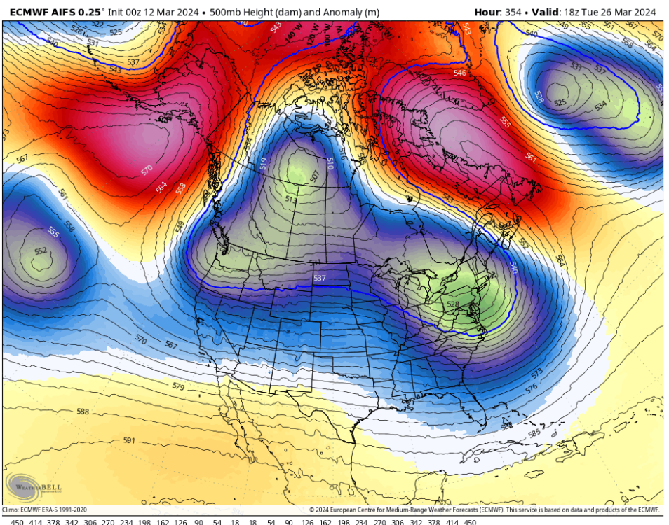
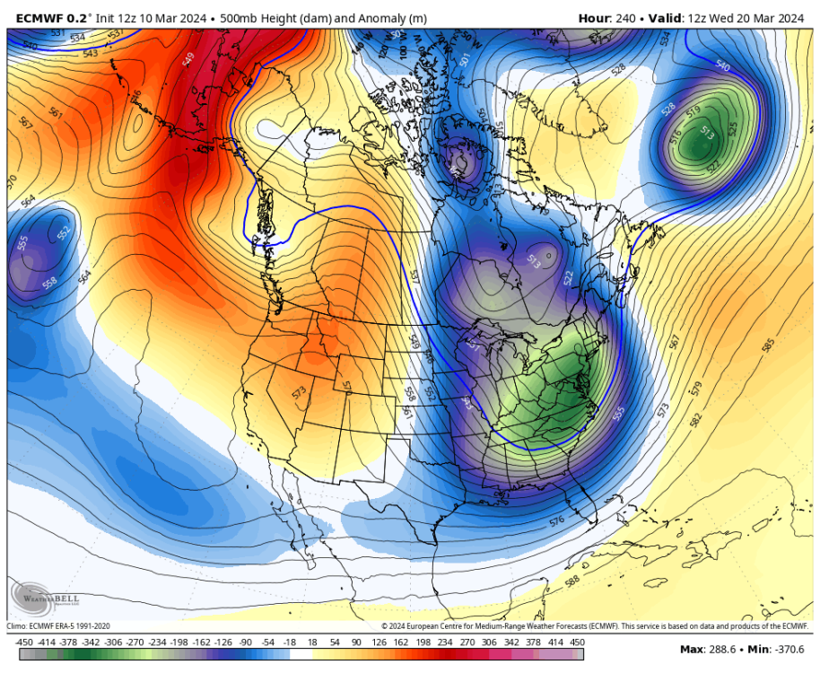
1970 has been coming up as an analog from the 500mb perspective at least.
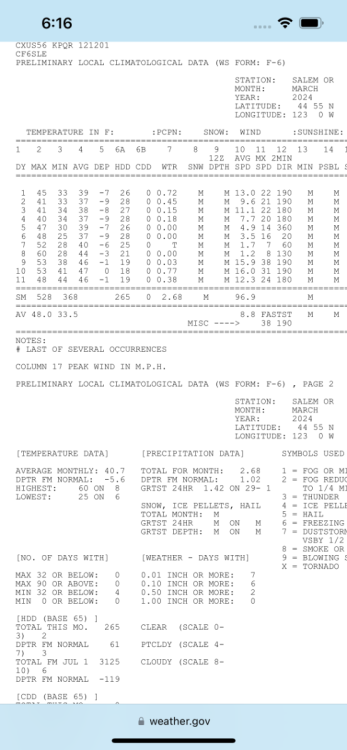
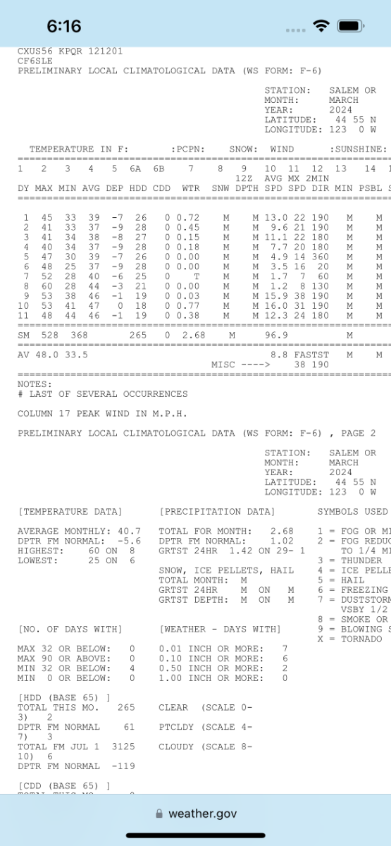
Just looked at March 1906 again. Seven consecutive lows of 30 or lower in SEA, and three consecutive highs in the 34 to 38 range after the 10th. Freeking impressive alright!