


FrostFuzz
-
Posts
21 -
Joined
-
Last visited
Everything posted by FrostFuzz
-
2022-2023 California and Southwest Weather Thread
FrostFuzz replied to Thunder98's topic in West of the Rockies
I think any precipitation that falls before about mid day Friday has a chance to be at least partly snow here on the west side of Vegas. Question is will we get any notable precip by then. -
2022-2023 California and Southwest Weather Thread
FrostFuzz replied to Thunder98's topic in West of the Rockies
Some models are really gung ho about low elevation snow next week. Love tracking systems like this -
2020 - 2021 California and Southwest Weather Discussion Thread
FrostFuzz replied to Thunder98's topic in West of the Rockies
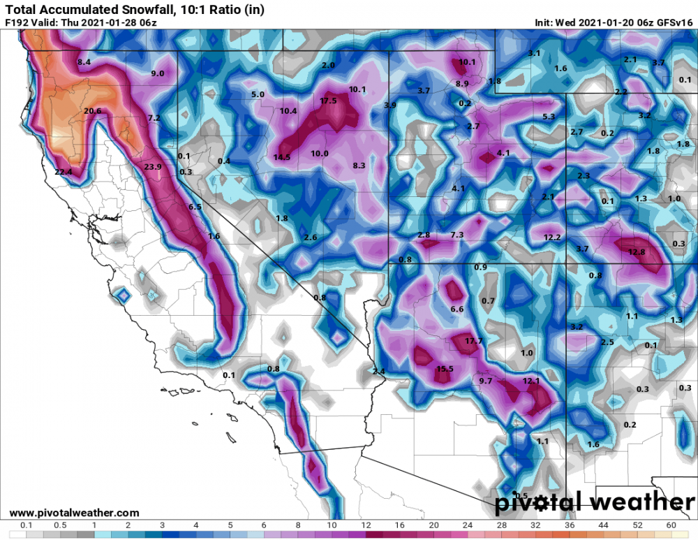
In the past 12 hours The Euro, the v16 GFS, and the Canadian have all shown snowfall in the Inland Empire next week. We got some flurries in isolated spots in February 2019, but as far as I know nothing stuck below 2000ft. The last significant snow event we've gotten here was in December 2014, but that event was driven by evaporative cooling driving snow levels way lower than they would have otherwise. Next week's system doesn't have that. It'll just be relying on cold air, which makes me much more skeptical that it'll actually pan out. It's just so hard for it to get that cold down here with enough moisture for snow. Still excited to watch this just for its potential.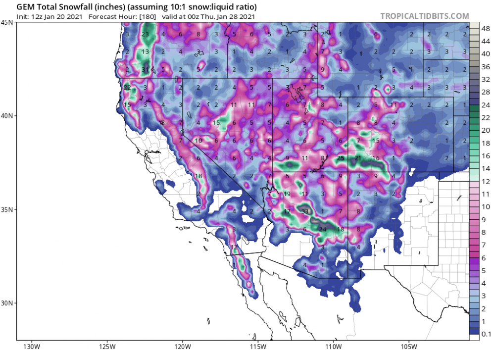
.thumb.png.bf7f2721331c9cfb8f634fcf9f6ff6cf.png)
- 4890 replies
-
- 1
-

-
- california
- climate
- (and 1 more)
-
2020 - 2021 California and Southwest Weather Discussion Thread
FrostFuzz replied to Thunder98's topic in West of the Rockies
It looks likely that we could get our first significant rainfall of the season here in southern California this weekend. NW flow could somewhat shaft LA and Ventura county coasts though.

-
2019 California and Southwest Weather Discussion Thread
FrostFuzz replied to Thunder98's topic in West of the Rockies
This upcoming system for Wednesday night and Thursday has been really fun to track, and probably an absolute nightmare for the NWS. As of the most recent model runs this system seems to give much of southern California (including the IE which isn't getting too much from this current system) very good rainfall totals. That being said there are a couple of factors that make this forecast uncertain even though it is very close. The main issue is that a surface low develops which means that the winds wrap around and actually come from an offshore direction. This "Santa Ana" effect can dry the lower levels, meaning that if the low is even a little bit further from the coast rainfall totals can be cut dramatically or even be removed entirely. Even 100 miles can make a huge difference, which is nothing compared to the scale of these storms. My primary interest wrt this stems from the evaporation cooling potential. There's a non-zero chance parts of the IE sees some flurries with this system. So many things have to go right for that it really isn't likely at all, but it's still fun to track.- 2165 replies
-
- 1
-

-
- 2019
- california
- (and 2 more)
-
2019 California and Southwest Weather Discussion Thread
FrostFuzz replied to Thunder98's topic in West of the Rockies
Rainfall has been very nice on this thanksgiving holiday. There's been about 1.5 inches here since midnight (Wish I had my own rain gauge set up so I could give a more precise total). Closing in on 2 inches overall and the rain is still coming down. It's 40F here right now. Apparently it's snowing in parts of Fontana and sticking in Beaumont already. Maybe I can manage some here tonight -
2019 California and Southwest Weather Discussion Thread
FrostFuzz replied to Thunder98's topic in West of the Rockies
Yeah the entire 12z suite looks considerably less impressive. Still a good storm but that was a pretty big shift from the GFS, Canadian, and Euro -
2019 California and Southwest Weather Discussion Thread
FrostFuzz replied to Thunder98's topic in West of the Rockies
I was on the accuweather forums with the same username. A bit more regular there. I was actually in Riverside at the time, now I spend most of my time in San Diego though. The NWS San Diego is starting to advertise this system. It's still pretty early but models have been consistently suggesting a very hard hitting system for at least the last day or two. Given the time frame it's probably more important for them to acknowledge the possibility of a significant event.- 2165 replies
-
- 1
-
-
- 2019
- california
- (and 2 more)
-
2019 California and Southwest Weather Discussion Thread
FrostFuzz replied to Thunder98's topic in West of the Rockies
This thanksgiving storm is looking really promising in southern California. The 0z Euro gives a fantastic soaking and the GFS also has some nice rain with some relatively low snow levels. Definitely keeping an eye on it. I'll probably be in the Riverside area (Menifee) for it. This last system was pretty nice here in San Diego. Individual showers were very isolated though even down here. I prefer a good widespread soaking. -
2017 California/Southwest Weather Thread
FrostFuzz replied to Thunder98's topic in West of the Rockies
Wow the 12z GFS goes nuts with well over 3 inches of rain in a 9 hour period and over 4 inches total on Sunday in LA. When's the last time there's been a single day storm like that? 2010 didn't have anything like that. 2005? Models have been inconsistent with that storm in particular but what a run. Now that I think about it I remember there being a storm... a quick search brings up November 30 2007. It dumped 2-4+ inches throughout the inland empire, but didn't hit the coastal areas anywhere near as hard if memory serves me correctly. Wunderground says Riverside got over 2 inches but LA only got half an inch. That was an unusual storm. -
The NWS calling for snow levels down to 2000 ft or lower now. Could be interesting... Also, I made a little map a couple of days ago comparing this coming event to Nov. 2004 if anyone remembers that one. The top one was in 2004 and the bottom was the GFS forecast. Of course I'm sure there were plenty of differences. This event will have a colder core and I would guess 2004 had better convective parameters, at least in southern California. But as far as 500mb vorticity is concerned they look pretty damned similar. In this image 2004 had a better over water trajectory, but since then this storm has trended further over water on the GFS. http://i1176.photobucket.com/albums/x333/FrostFuzz/2004vs2014_zps477f2f2f.jpg Another kinda comparable storm might be February 14, 2008. That one was an inside slider as well, although I think it favored areas further south.
-
This storm is still looking good. The Euro is showing a ton of rain for LA. The Wednesday/Thursday wave is more of a question mark but it also looks pretty good on the Euro.

.png.9820b429451b3883e276ff2d56566629.png)


