paulb/eugene
-
Posts
500 -
Joined
-
Last visited
Everything posted by paulb/eugene
-
February 2021 PacNW Weather Discussion
paulb/eugene replied to BLI snowman's topic in West of the Rockies
18z NAM tracking first low significantly farther N. Seems busty for PDX -
February 2021 PacNW Weather Discussion
paulb/eugene replied to BLI snowman's topic in West of the Rockies
F*ck the models, just use the GOLU
-
February 2021 PacNW Weather Discussion
paulb/eugene replied to BLI snowman's topic in West of the Rockies
With 925mb and 850mb temps above zero, looks like ice for Portland. South winds work way north to Salem by Friday morning. I hope the Euro is right -
February 2021 PacNW Weather Discussion
paulb/eugene replied to BLI snowman's topic in West of the Rockies
Kind of like saying an old man getting heart attack while shoveling snow was killed by the snowstorm. -
February 2021 PacNW Weather Discussion
paulb/eugene replied to BLI snowman's topic in West of the Rockies
Duh I should have thought of that but I’m biased by my thought that the fires were preventable . Negligence on part of utility companies plus methamphetamine addiction probably played a bit of a role. -
February 2021 PacNW Weather Discussion
paulb/eugene replied to BLI snowman's topic in West of the Rockies
Without any south winds the heavy cold air will have no problem spilling south from the Gorge. -
February 2021 PacNW Weather Discussion
paulb/eugene replied to BLI snowman's topic in West of the Rockies
fake snow in Willamette Valley.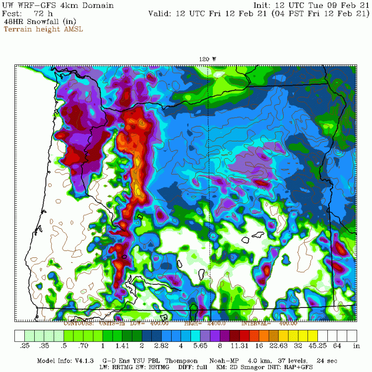
-
February 2021 PacNW Weather Discussion
paulb/eugene replied to BLI snowman's topic in West of the Rockies
That appearance on the model suggests all that is freezing pcpn in Willamette Valley. Anytime the snowfall amounts follow a cold pool/dendritic pattern like that the model is wrong . That is an ice storm . -
February 2021 PacNW Weather Discussion
paulb/eugene replied to BLI snowman's topic in West of the Rockies

-
February 2021 PacNW Weather Discussion
paulb/eugene replied to BLI snowman's topic in West of the Rockies
Still very worrisome for high impact ice storm throughout the Willamette Valley. 9-12 km resolution models do not sufficiently account for the gorge. Unreal snow amounts for WA, and perhaps unreal amounts of ice in the Willamette Valley. If this materializes it will be the most costly weather event for Oregon since 1996 floods -
February 2021 PacNW Weather Discussion
paulb/eugene replied to BLI snowman's topic in West of the Rockies
Looking at the NAM model 12z runs in 12km and 3km resolution is textbook lesson ....the 12km run has temp of 48 degrees in Eugene in 60 hours whereas the 3km resolution has Eugene 11 degrees colder, 37F. 3km resolution accounts for the Columbia Gorge better. The extent of the sub freezing layer in the Willamette Valley will me more than the GFS and Euro are showing but will just be freezing rain down here. I was celebrating the lack of extreme freezing rain predictions on the last few model runs but at same time know that we are not out of the woods. enjoy your snow up north...Gloat all you want up there, am looking forward to hearing of some big totals. -
February 2021 PacNW Weather Discussion
paulb/eugene replied to BLI snowman's topic in West of the Rockies
Anyone with ukmet freezing pcpn map? -
February 2021 PacNW Weather Discussion
paulb/eugene replied to BLI snowman's topic in West of the Rockies
Looking at surface pressure plots and temps the 00z NAM looks a bit colder, may trend S with the first low -
February 2021 PacNW Weather Discussion
paulb/eugene replied to BLI snowman's topic in West of the Rockies
Yes. I lived in SW Portland near Gabriel Park then. It was cold rain when it started then turned to freezing rain, did not change to snow until the following morning, just a big ugly mess. Meanwhile, just on the other side of the west hills , not more than 2-3 miles away as crow flies, it was snowing downtown PDX. Clark County did really well. I think they got 6-10”. Fascinating and frustrating at the same time. At least it is now not an El Niño -
February 2021 PacNW Weather Discussion
paulb/eugene replied to BLI snowman's topic in West of the Rockies
The 18z Euro speaks of Dec 1996 to me. The low level cold air will makes it way through gorge but not enough cooling aloft for snow Columbia River S. Would be ice event for PDX, with limited QPF. -
February 2021 PacNW Weather Discussion
paulb/eugene replied to BLI snowman's topic in West of the Rockies
I take that back. NW Oregon clobber track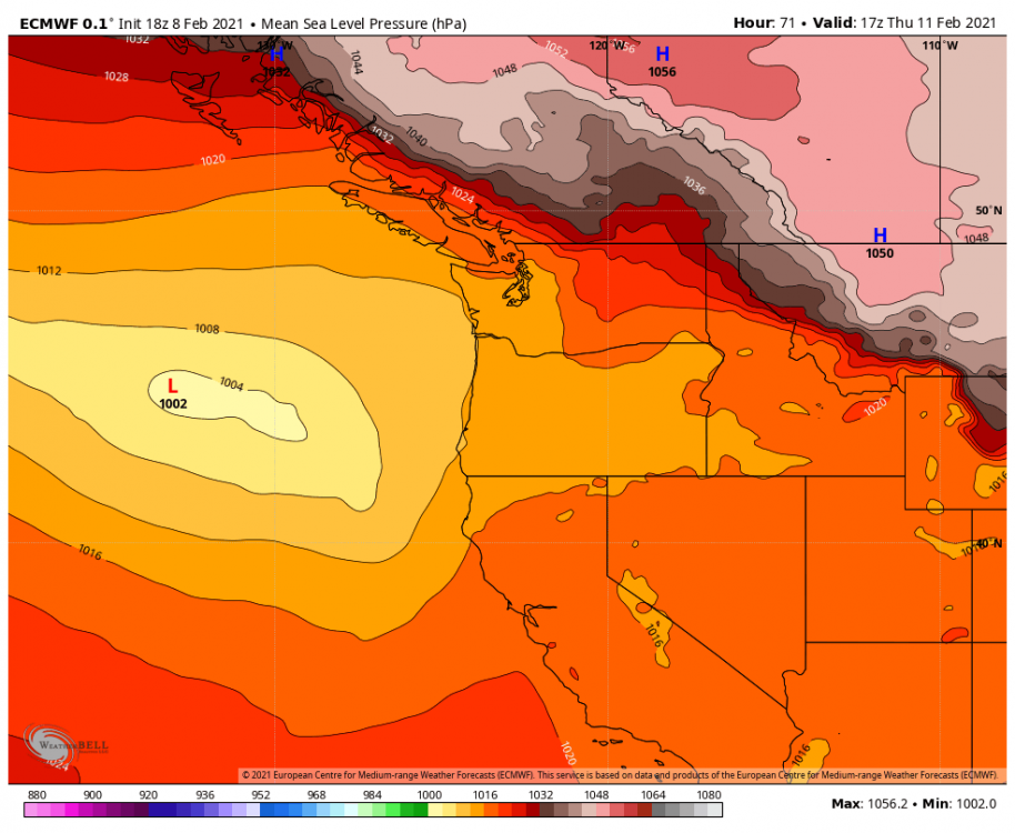
-
February 2021 PacNW Weather Discussion
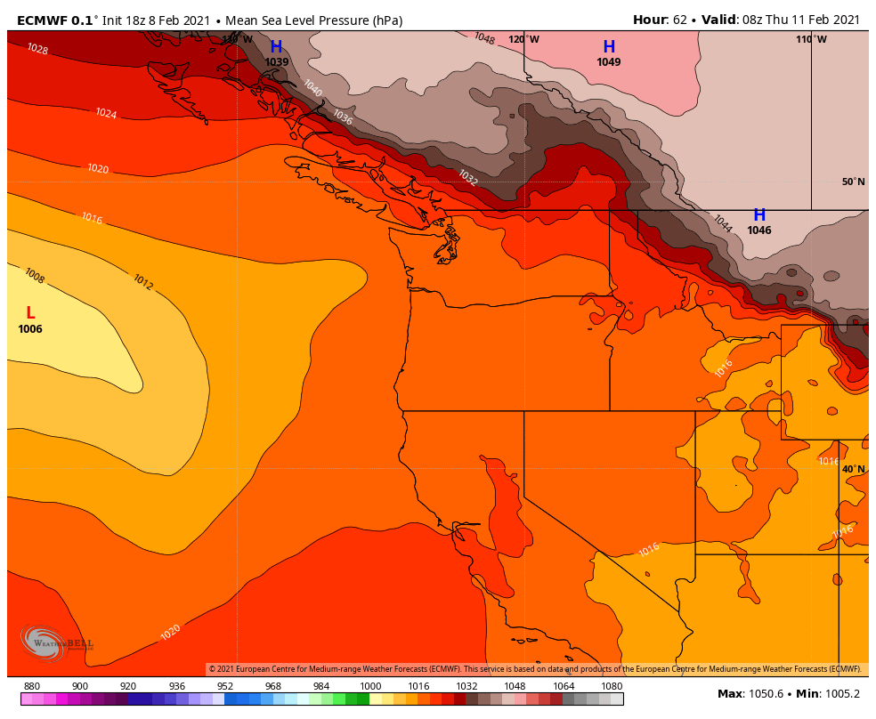
paulb/eugene replied to BLI snowman's topic in West of the Rockies
The low will track in direction of that orange middle finger toward Grays Harbor
-
February 2021 PacNW Weather Discussion
paulb/eugene replied to BLI snowman's topic in West of the Rockies
-
February 2021 PacNW Weather Discussion
paulb/eugene replied to BLI snowman's topic in West of the Rockies
My review of 18z euro thus far is that it suggests low later this week will track slightly farther north than on the 12z -
February 2021 PacNW Weather Discussion
paulb/eugene replied to BLI snowman's topic in West of the Rockies
Where’s the Korean -
February 2021 PacNW Weather Discussion
paulb/eugene replied to BLI snowman's topic in West of the Rockies
https://www.weather.gov/help-map -
February 2021 PacNW Weather Discussion
paulb/eugene replied to BLI snowman's topic in West of the Rockies
What color is Ice Storm Watch? -
February 2021 PacNW Weather Discussion
paulb/eugene replied to BLI snowman's topic in West of the Rockies
Check out that sleet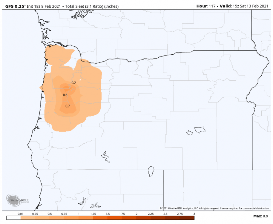
-
February 2021 PacNW Weather Discussion
paulb/eugene replied to BLI snowman's topic in West of the Rockies
The odds for a significant snowstorm in PDX at end of week just went up big time with that NAM run. I am concerned about potential for some snow falling in Eugene before the inevitable ice. Wet snow falling on the trees only adds to the surface area and weight from the ice. obviously this cuts down on snow to start with in Washington but am not worried for them as they will get some ultimately. -
February 2021 PacNW Weather Discussion
paulb/eugene replied to BLI snowman's topic in West of the Rockies
Twice the ice is eight times the weight. Ice storms suck