


Phil
-
Posts
44497 -
Joined
-
Last visited
-
Days Won
262
Posts posted by Phil
-
-
3 minutes ago, TT-SEA said:
I wouldn't want to miss a sunny 70-degree weekend at home in April. Supply of those perfect days is limited... and always prefer to have stormy/rainy weather at home when we are gone.
But you’ll see more sunny/70+ wx in SC than you would in WA. So what are you missing? I don’t get it.
If I was missing a 4” snow event here but traveling somewhere where a 12”+ snowstorm was headed, I wouldn’t be salty about “missing” the 4” one. That’s just weird.
-
 1
1
-
-
3 minutes ago, Anti Marine Layer said:
There was no El Nino in spring 2023 and it was one of our coolest and cloudiest springs on record. It's extremely rare to have the jacarandas not bloom until late June or early July here, but that's what happened last year.
Tropical forcing was already El Niño like by spring 2023, despite the lack of an official declaration.
January 2023 was an intraseasonal event but was also a harbinger of things to come. Couldn’t know this in real time, but the ocean/atmosphere system had already made up its mind about where it was going at that point.
-
 2
2
-
 1
1
-
 1
1
-
-
10 minutes ago, Cascadia_Wx said:
Them’s fightin words.
Can I this one a J***e pattern? If it isn’t, I can’t imagine what would meet the criteria.

-
1
-
 1
1
-
 1
1
-
-
8 hours ago, Meatyorologist said:
How deep into the year can you see snow? Seattle proper has arguably seen flurries as deep into the Spring as May 1st (at night w/o accumulation and probably a precip mix of course), so I imagine May is no issue up there.
I’ll never forget how it snowed on May 9th, 2020. Absolutely obliterated 850mb cold records with that one.
1 hour ago, TT-SEA said:Don't like leaving on such a gorgeous day... but don't mind missing the next week after today.
Why does it matter if you’re traveling somewhere even warmer/sunnier? It’s not like you’re missing a snowstorm or something.
28 minutes ago, Anti Marine Layer said:Not if the California cold and wet, PNW warm and dry curse that began in 2023 continues.
You mean El Niño? Sadly yes, it is on its deathbed.
-
3 minutes ago, TT-SEA said:
It was 61 at SEA today which is normal. Dewpoint was in the 30s and there was decent north wind. Probably felt a little chilly there. If that qualifies for a heat risk then the map will be bright red everywhere all summer.

2 months from now it wouldn’t, though. Climatology is factored in.
For instance, the first hot pattern of summer is often harder on the general population, since people aren’t acclimated yet.
-
4
-
-
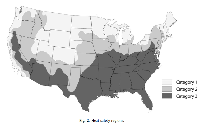
I’ve also heard that a heavier emphasis will be placed on WBGT (wet bulb globe temperature) w/rt heat headlines in the future. It is a better measure than heat index.
Thresholds will vary by region, of course. Criteria in SE US/Desert SW will be different than the PNW, for instance.
-
2
-
-
4 minutes ago, Frontal Snowsquall said:
Interesting parameter they use. For today they had PDX in the yellow which is minor risk. This will be fun to track this warm season.
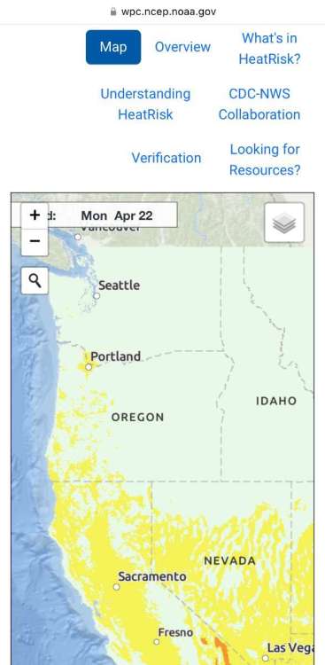
Yeah basically it’s calculated with respect to each locations’ climatology (in addition to factors such as duration, diurnal cycle, and parameterization to extrapolate dewpoint, etc.
-
1
-
-
New product from NOAA. Suspect it will be referenced heavily this summer as the lower-48 spontaneously combusts.
-
2
-
1
-
 1
1
-
1
-
 1
1
-
-
Wow the low was 13°F this morning in Canaan Valley, WV. That climate can do such weird things.
-
1
-
1
-
 1
1
-
 2
2
-
-
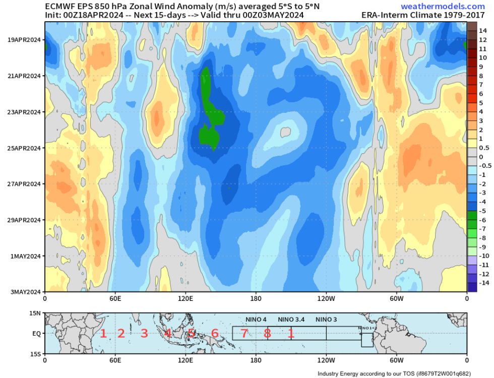
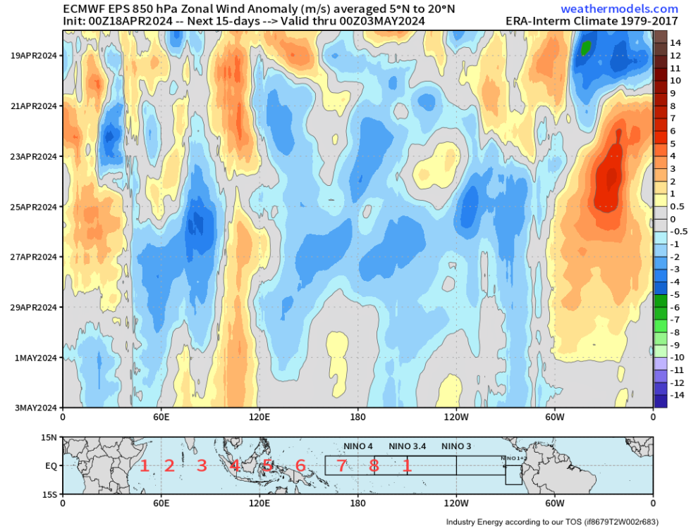
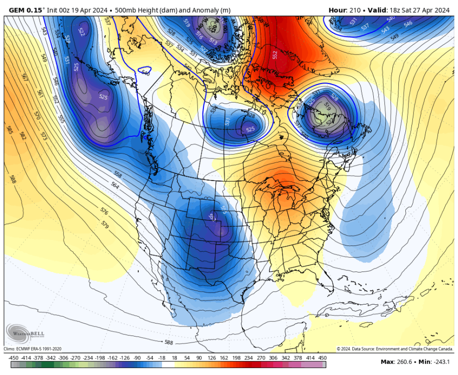
7 minutes ago, TT-SEA said:
Might be an entire west coast situation coming up. Probably related to the final warming post above.
.thumb.png.fa769d513e56bd2b0dccafef981cdecd.png)
It’s arising via a combination of the final warming/seasonal change, the MJO, and the decay of the niño base state. It’s never just one thing.
-
5
-
-
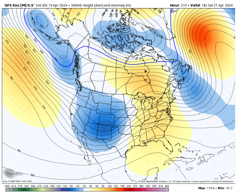
15 hours ago, Cascadia_Wx said:
Eh. Today will go on the books as another very warm day. Tomorrow barely gets us to average then it’s back to more ridging. Followed by another “troughy” period that’s getting more toned down by the day.
Today was fun, but it would be more exciting if it were a longer lasting crash to significantly colder or wet weather. Just my opinion.
Dude, the mean trough position is in the West/PNW for the entirety of the 00z EPS run. And it has been for the last 7 weeks, too.
The ridgy periods have been relatively transient up there compared to other parts of the country. It can’t be troughy 24/7.
-
3
-
1
-
-
I can’t believe how quiet the nights are out here. You can hear a pin drop. So different from back home where the distant sound of traffic on I-495 fills the air.
-
14 hours ago, Meatyorologist said:
Or maybe by force of habit it LOCKS IN PERMANENTLY

You bastard.
-
1
-
 1
1
-
-
8 hours ago, TT-SEA said:
Nino not crashing really hard yet. I am sure its coming though.

Yeah, major switch in winds coming up both in tropics and NH-extratropics. Will cool ENSO and NPAC waters.
-
4
-
-
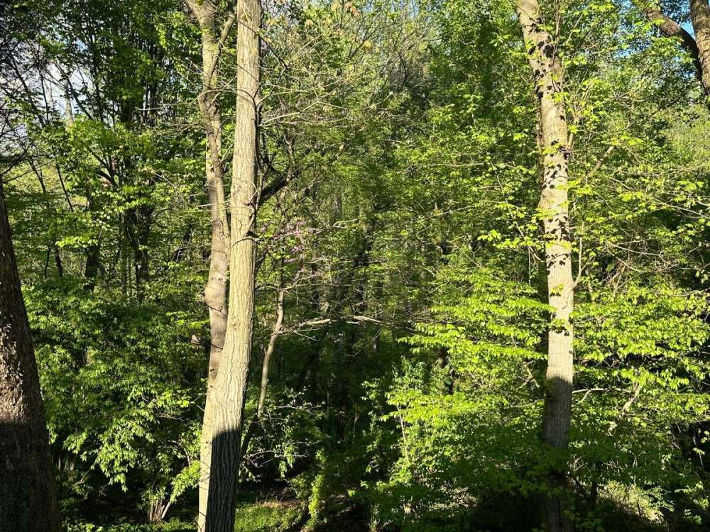
15 minutes ago, TT-SEA said:
That is not in the mountains... only at 564 ft in elevation. The leaf out there is behind here which is surprising because I think it’s been much warmer there. But it looks like that is quite a bit north of DC so maybe not as warm.
That pic was at ~ 1200ft. Technically we’d just passed Hancock. Can’t see the terrain because it’s in the cloud deck.
But definitely at least 2 weeks behind DC, probably more. Took this yesterday, foliage has been emerging quite rapidly.
-
4
-
-
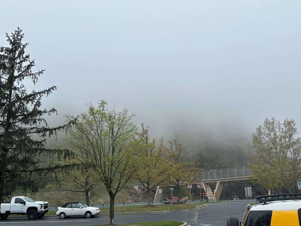
Just below the cloud deck here driving thru Hancock.
-
3
-
1
-
 1
1
-
-
25 minutes ago, ChrisEl Elyon said:
Interesting View from Eric Snodgrass
His analogs for May are..

Somehow he has 1969 and 1987 (2nd year niños) in there but leaves out closer matches like 2010? I get it’s a subseasonal analog pool but still can’t quite wrap my head around that.
Edit: he does have 2010 in there (I missed it) but a good number of those years shouldn’t be included at all IMO.
-
1
-
-
Honestly I wish the operational GFS didn’t exist. Always shows the most amazing, enjoyable solutions but it never happens. Especially in the spring.
06z has a sexy-af tropopause fold/TPV lobe swinging thru next week but not a single GEFS/EPS/GEPS member has it. Idk how it strays so far off the reservation, but it be trollolololin’.
-
1
-
-
Heading out to appalachia for a bachelor party. Will do my very best not to drunk-post this weekend but make no promises.
-
1
-
1
-
 1
1
-
 1
1
-
 1
1
-
 1
1
-
-
I can smell the ocean.
 Immediately knew a PNW-style backdoor marine push had moved thru overnight.
-
4
-
-
5 hours ago, Meatyorologist said:
Beautiful pattern here. Looks whet.
Maybe if we get this pattern out of the way in spring it’ll reverse during the summer.
-
1
-
1
-
 1
1
-
 1
1
-
-
The 00z CMC and GEFS both have that zonal/onshore flow pattern establishing during week-2. A J***e delight.
-
2
-
1
-
1
-
1
-
-
4 hours ago, ChrisEl Elyon said:
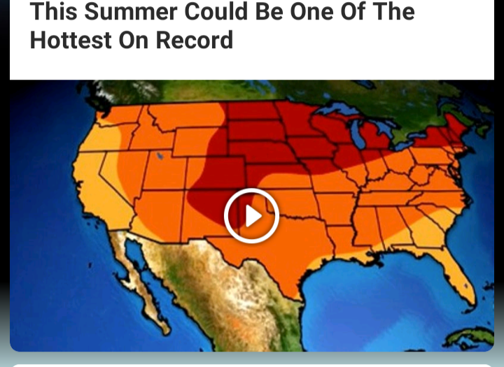

Been saying this for awhile. 2024 will probably be the hottest summer on record for the lower-48. All forcing components are lining up in the worst way possible.
-
1
-
3
-
-
5 hours ago, TT-SEA said:
Not sure what NOAA is seeing...
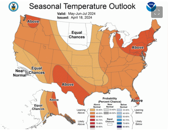
Where they have “equal chances” is probably where the warmest anomalies will end up. Lmao.
-
1
-
1
-


.png.0c9523bb0defd41c6d33d245abe1717f.png)


April 2024 Weather in the PNW
in West of the Rockies
Posted
I deny fairytales, yes. 2016/17 wasn’t a niña. Niño 3.4 was in positive territory before the end of January.
Look at SSTA maps from Feb-Apr 2017. Legit niño-costero signature in both SSTAs and OLR/atmospheric circulation.