Phil
-
Posts
44503 -
Joined
-
Last visited
-
Days Won
262
Everything posted by Phil
-
That’s a scary SSTA signature in the Atlantic. Jet fuel.
-
Holy shit @ the tornado on the ground in AI right now.
-
You’re experiencing that exact same weather RIGHT NOW. At a beachfront resort nometheless. Get out and enjoy it instead of sitting inside hoping for the same conditions a week from now, which may not even happen. The way your mind works
-
Is this bait?
-
You would eat that.
-
Have you been getting enough sleep?
-
wtf is that? It looks like a cake made of salmon with guacamole icing.
-
What’s life without a little pleasure?
-
Easiest cure for cravings is the smell of beef, turkey, or chicken. All three of those are revolting and I’d sooner eat pine needles off the muddy ground than consume such disgusting poison. Fish, dairy, and veggies all day, baby. Keeps the body young.
-
Normally I’m meh about macaroni salad, but I’m calorie/carb restricting now and that pic has me fukkin RAVENOUS.
-
Meanwhile it’ll be in the 90s here next week. The warm season lasts almost half the year now. Ridiculous. That is trippy-beautiful. Would love to be up there. Statistically speaking, weak-moderate. But that’s not always true depending on the entirety of the system state. In some situations, a stronger niña will perform better up there, while in other situations a lack of any ENSO/LF component is preferable.
-
I get sleep paralysis every now and then but I never hallucinate. That just seems weird.
-
You’d be happy living there.
-
You can’t just look at one month w/rt the establishment of seasonal scale patterns. There is too much intraseasonal variability at that timescale. Especially with ENSO transitioning. A lower frequency approach is required, no way around it.
-
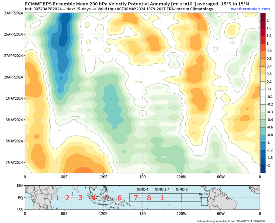
The impressive speed of this CCKW across the Pacific is another indicator the niño is losing its grip on higher frequency elements of tropical forcing.
-
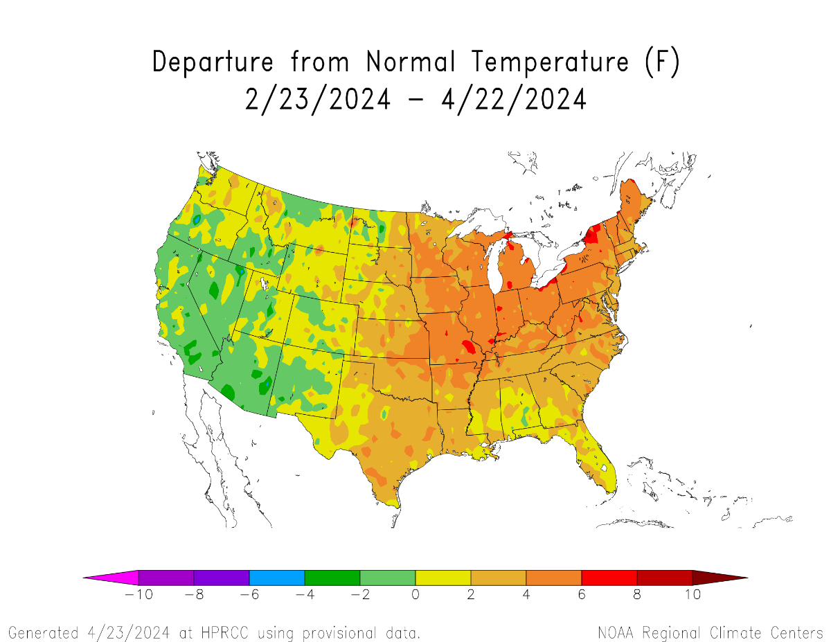
The last 2 months have already established a warm CONUS pattern which, when manifesting during post-niño springs, almost always precedes warm summers nationally. This bears striking resemblance to spring 2010. Only difference is cool anomalies aren’t as prevalent (I suspect the same will hold true during the summer).


-
This would be a closer match to 2010 than 2012. Because 2012 wasn’t coming off a strong niño, where-as there are still niño-like elements to the current base state (albeit attenuating). Of course there will be subseasonal scale differences as well. Unwise to project from any analog pool alone.
-
You don’t have a point. The context was *leaving town* on a day with desirable weather, to a destination with more desirable weather. Not *returning home* to desirable weather.
-
You feel a lot of things.
-
A more in-depth analysis of the event from Rollenbeck at al, 2022: https://www.mdpi.com/2072-4292/14/4/824 Note the murky overlap between EOF(s) defining niña-modoki and niño-costero. The truth is ENSO has multiple spectra, and the niño 3.4/ONI metric is out of date (and should be done away with entirely) because it fails to capture several components of ENSO variability.
-
The 2023/24 niño emerged from a niño-costero event. First time we’ve seen that type of evolution before the 1976 Pacific Climate Shift. This is fascinating stuff when you really dig into it.
-
This is an informative read: https://link.springer.com/article/10.1007/s13753-017-0151-8
-
I think you know the answer to that one.
-
The Niño 3.4 number doesn’t tell the whole story. There was a healthy, quasi-stable niña low pass signal during the first part of that winter. The atmosphere was well coupled. There was no major intraseasonal event (MJO/SSW et al) that could have torpedoed the base state like that. Not only did it abruptly fall apart without warning, but come February the atmosphere had coupled to the niño-costero signature as if it was a mature niño event. That’s not supposed to happen. It’s cute you think it’s as simple as a cursory glance at the niño 3.4 number, though. I used to think that way..when I was 11yrs old.
-
Colorado-like diurnal cycle today. 35°F at 7AM to 71°F by noon. Will miss this come July when it feels nastier at 9PM than it did at noon.