

Perturbed Member
-
Posts
5085 -
Joined
-
Last visited
-
Days Won
2
Everything posted by Perturbed Member
-

January 2024 Weather in the PNW (Part II)
Perturbed Member replied to Meatyorologist's topic in West of the Rockies
Yeah that slug of moisture should be widespread snow for the metro area, our best chance to get a couple inches I think. -
January 2024 Weather in the PNW (Part II)
Perturbed Member replied to Meatyorologist's topic in West of the Rockies
It has been dumping like this for a while now near Longview/Rainier. Should have some impressive totals there.
-
January 2024 Weather in the PNW (Part II)
Perturbed Member replied to Meatyorologist's topic in West of the Rockies
Had a brief gap in the precip but its back now and 100% snow, absolutely nuking. Should be able to stack several inches if the precip can remain steady like this. -
January 2024 Weather in the PNW (Part II)
Perturbed Member replied to Meatyorologist's topic in West of the Rockies
Astoria up to 28F but they have been under moderate to heavy precip for a long time. The ice accumulations there have to be getting a bit absurd.
-
January 2024 Weather in the PNW (Part II)
Perturbed Member replied to Meatyorologist's topic in West of the Rockies
Yeah shouldn't be long for you either. The rest of this afternoon and evening should be pretty fun. Hopefully we can get in on some of that band setting up north, we might end up being a hair too far south. -
January 2024 Weather in the PNW (Part II)
Perturbed Member replied to Meatyorologist's topic in West of the Rockies
About 70% snow here and gradually increasing, think this is the mid levels finally cooling off. -
January 2024 Weather in the PNW (Part II)
Perturbed Member replied to Meatyorologist's topic in West of the Rockies
Yeah. The Euro and GFS have been consistent focusing that up north aligned with Longview. Likely the sweet spot for this whole event or somewhere close to it.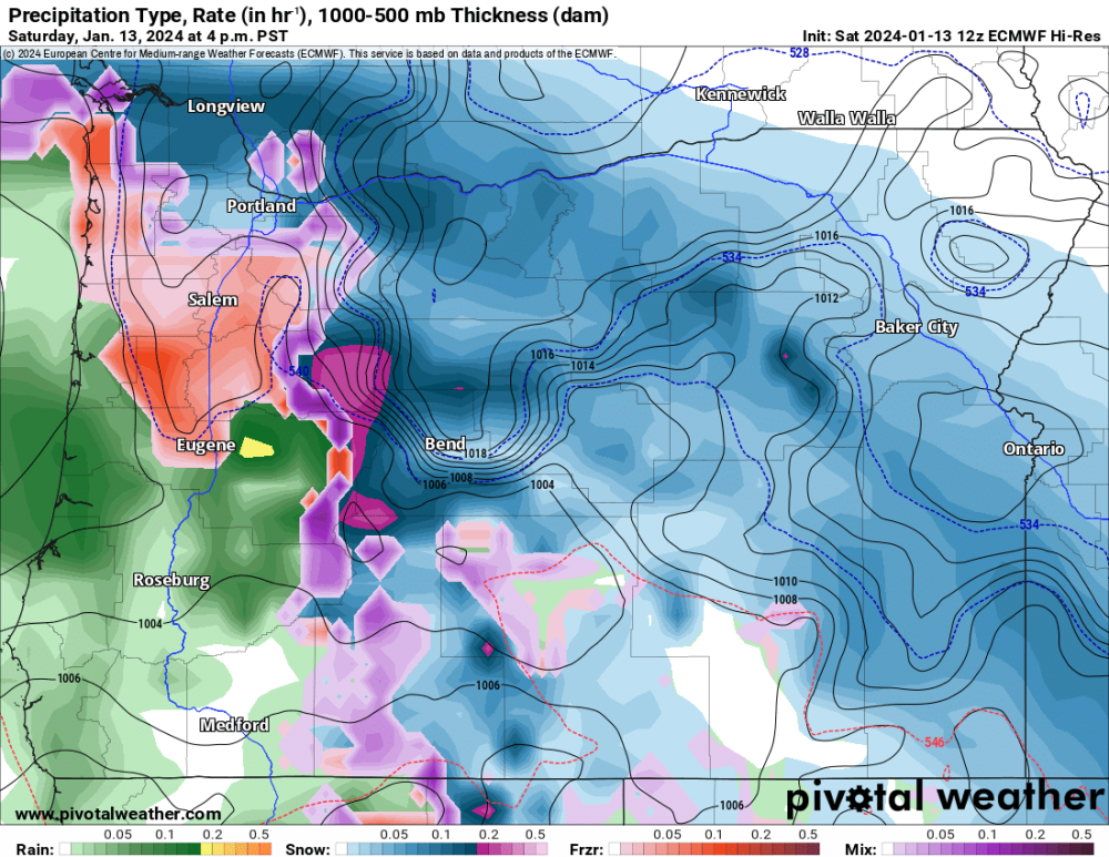
-
January 2024 Weather in the PNW (Part II)
Perturbed Member replied to Meatyorologist's topic in West of the Rockies
I'm confident it will switch back to all snow, that is well supported by all the decent models. I just hope we still have plenty of juice after that point. I think that deformation will be more focused on areas north, hopefully we won't get stuck with precip rates that are too light. -
January 2024 Weather in the PNW (Part II)
Perturbed Member replied to Meatyorologist's topic in West of the Rockies
It is trying to go back to mostly snow around here but the p type has been fluctuating constantly for a while. Hopefully the mid levels only cool from here. -
January 2024 Weather in the PNW (Part II)
Perturbed Member replied to Meatyorologist's topic in West of the Rockies
I have never seen such a back and forth snow and sleet event like this here. The mid levels here are just right on that line between snow and sleet and keep waffling around. Only other time I've seen something like this was in the gorge maybe back in 2016 where I saw the most bizarre mix of over a foot of sleet, snow and ZR all blended together. They were layered in such a way where you could tell the P types were changing back and forth constantly as it fell. -
January 2024 Weather in the PNW (Part II)
Perturbed Member replied to Meatyorologist's topic in West of the Rockies
27F and pouring ZR in Astoria. Must be just nasty out there.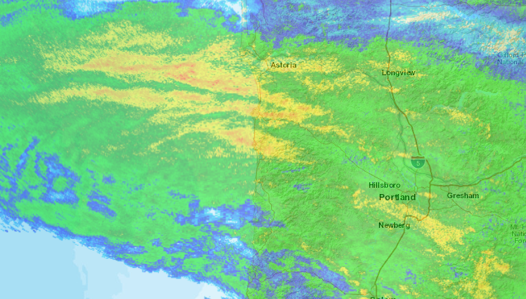
-
January 2024 Weather in the PNW (Part II)
Perturbed Member replied to Meatyorologist's topic in West of the Rockies
This was the snow total for the whole event that the 06z NAM showed right before the precip hit. I have about 2 inches right now, which is a bit more than 0. I think the NAM failed pretty miserably with this. That being said, I'm 90% sleet now... -
January 2024 Weather in the PNW (Part II)
Perturbed Member replied to Meatyorologist's topic in West of the Rockies
Good looking system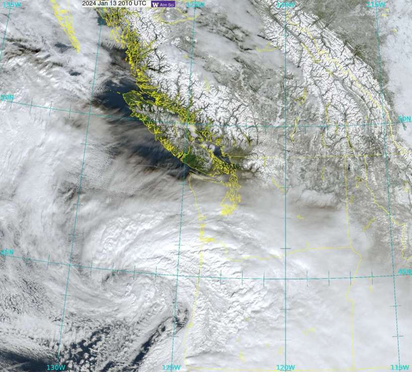
-
January 2024 Weather in the PNW (Part II)
Perturbed Member replied to Meatyorologist's topic in West of the Rockies
I was just watching that stream, some guy's car hood came off and flew off down the hill from those gusts. Completely wild out there. -
January 2024 Weather in the PNW (Part II)
Perturbed Member replied to Meatyorologist's topic in West of the Rockies
Yeah this low is gonna need to put in some work this afternoon for us to crank up the accumulations. I am probably in the 1.25-1.5 inch range right now and there is a lot more sleet now, maybe 50% sleet falling. Hopefully mid levels start to cool soon. -
January 2024 Weather in the PNW (Part II)
Perturbed Member replied to Meatyorologist's topic in West of the Rockies
Similar deal here, it has always been snowing but sleet seems to occasionally mix in. Keeps going back and forth. Will probably eat into our potential totals a bit but at least it has remained mostly snow. I'm not complaining though, its been a fun and interesting event so far especially with the easterlies going crazy and the incredible temps. -
January 2024 Weather in the PNW (Part II)
Perturbed Member replied to Meatyorologist's topic in West of the Rockies
Back to all snow here and can't hear anymore sleet. Dumping snow. True battle between good and evil going on aloft. -
January 2024 Weather in the PNW (Part II)
Perturbed Member replied to Meatyorologist's topic in West of the Rockies
Yep, almost entirely snow here as well. I think if you are getting snow now, should be unlikely to lose it. Next few hours should be the peak temps aloft and then it should cool off. -
January 2024 Weather in the PNW (Part II)
Perturbed Member replied to Meatyorologist's topic in West of the Rockies
Some sleet mixing in here for sure now. It was dead silent all morning but now you can hear some sleet and ice crusted snow hitting the windows. -
January 2024 Weather in the PNW (Part II)
Perturbed Member replied to Meatyorologist's topic in West of the Rockies
15F, snowing hard and an angry icy east wind. Waited since the Feb 2014 event for a cold snow event like this and it is finally happening. Absolutely glorious. -
January 2024 Weather in the PNW (Part II)
Perturbed Member replied to Meatyorologist's topic in West of the Rockies
Yeah I've been saying 5-10 in for the metro with this and I think we can pull that off for most of us. Hopefully can hold the sleet off over the next few hours. -
January 2024 Weather in the PNW (Part II)
Perturbed Member replied to Meatyorologist's topic in West of the Rockies
Have remained snow here as far as I could tell. Possibly some cold air damming against the coast range helping out here earlier but glad to see mid levels wet bulbing to change over most of the metro to snow. Hopefully stays that way. Radar looking pretty nice. -
January 2024 Weather in the PNW (Part II)
Perturbed Member replied to Meatyorologist's topic in West of the Rockies
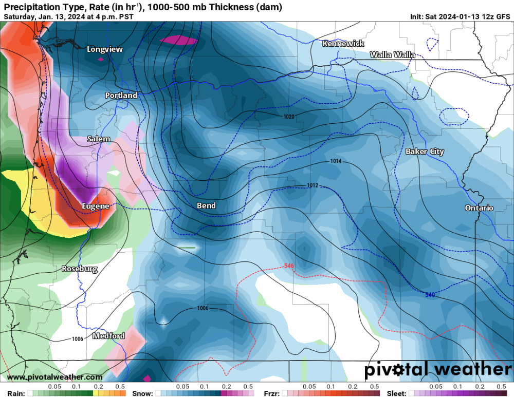
Fortunately, aside from the nasty NAM the WAA doesn't really look too horrific on most the models IMO. Sleet will be involved for parts of this in some of the metro but I'd be surprised if it actually derailed legit snowfall the way the 06z NAM is showing. The soundings on the Euro and GFS show a really modest warm layer compared to some of our previous sleet events. -
January 2024 Weather in the PNW (Part II)
Perturbed Member replied to Meatyorologist's topic in West of the Rockies
PDX NWS We also struggle to see how the warm nose will blast right into the PDX metro Saturday with such strong cold advection occurring from an already well-established, strong, and deep cold air mass. If there was one thing that surprised us the most over the past 12 hours, it`s how easily and how fast the cold air moved in, both from the north and east. This seems to be a signal that the cold air is stronger and deeper than modeled, and that the incoming low will help maintain a supply of cold air from the east (so long as it moves onshore south of Portland`s latitude). All this would point more toward a snow scenario than a sleet scenario for the PDX metro, with sleet more widespread in the Tualatin Valley and the Willamette Valley south of about Tualatin or Tigard. Somewhere further to the south in the Willamette Valley the cold air will be shallow enough for freezing rain rather than sleet, and there could be a lot of it. -
January 2024 Weather in the PNW (Part II)
Perturbed Member replied to Meatyorologist's topic in West of the Rockies
SE of Salem Looks pretty decent down there.


