

Perturbed Member
-
Posts
5085 -
Joined
-
Last visited
-
Days Won
2
Everything posted by Perturbed Member
-

January 2024 Weather in the PNW (Part II)
Perturbed Member replied to Meatyorologist's topic in West of the Rockies
Aren't we 48-60 hours out from the start of this? Or is that the joke, that we only buy in once all the snow has fallen? Nice to see how the models actually all look alike now. Still makes me a little nervous to be on that edge of the precip shield of course. I just have a good gut feeling about this setup though. -
January 2024 Weather in the PNW (Part II)
Perturbed Member replied to Meatyorologist's topic in West of the Rockies
I'm hoping that us being close to that boundary between the cold and this system can bring some local dynamics into play that may not be getting picked up on the global models. Doesn't always work out that way but it might be worth watching the higher resolution mesoscale models tomorrow to see if there are any hints of that. -
January 2024 Weather in the PNW (Part II)
Perturbed Member replied to Meatyorologist's topic in West of the Rockies
Low looked more juicy but did not increase QPF. It actually went down for PDX -
January 2024 Weather in the PNW (Part II)
Perturbed Member replied to Meatyorologist's topic in West of the Rockies
Looking good so far. 00z Euro is both more aggressive with the cold and stronger with the low. Win-win? -
January 2024 Weather in the PNW (Part II)
Perturbed Member replied to Meatyorologist's topic in West of the Rockies
Ok, stronger for sure. -
January 2024 Weather in the PNW (Part II)
Perturbed Member replied to Meatyorologist's topic in West of the Rockies
00z Euro is looking a bit south so far. -
January 2024 Weather in the PNW (Part II)
Perturbed Member replied to Meatyorologist's topic in West of the Rockies
Yeah, feels like it's never good to peak too early on these. I do like that the GFS didn't trend north though, its southward shift and the other models inching north feels like it might be a convergence on a solution. Hopefully more subtle changes from here on out...probably wishful thinking though. -
January 2024 Weather in the PNW (Part II)
Perturbed Member replied to Meatyorologist's topic in West of the Rockies
GFS is much wetter over PDX, going for an extinction level event. -
January 2024 Weather in the PNW (Part II)
Perturbed Member replied to Meatyorologist's topic in West of the Rockies
Based on the Hour 18 frame, pretty obvious the low is going to Pacific City. -
January 2024 Weather in the PNW (Part II)
Perturbed Member replied to Meatyorologist's topic in West of the Rockies
It has its place. It is pretty decent for surface level details at close range. Not too great beyond 48 hrs IMO. -
January 2024 Weather in the PNW (Part II)
Perturbed Member replied to Meatyorologist's topic in West of the Rockies
12z vs 18z Euro, the trend since this morning is pretty obvious. The Euro and NAM both shifted north pretty similarly. Even a 25-30 mile shift further north on the 00z Euro would give PDX much bigger totals. -
January 2024 Weather in the PNW (Part II)
Perturbed Member replied to Meatyorologist's topic in West of the Rockies
00z vs 18z -
January 2024 Weather in the PNW (Part II)
Perturbed Member replied to Meatyorologist's topic in West of the Rockies
Yeah the 2nd system slams PDX -
January 2024 Weather in the PNW (Part II)
Perturbed Member replied to Meatyorologist's topic in West of the Rockies
00z NAM is way north with the 2nd round 00z vs 18z -
January 2024 Weather in the PNW (Part II)
Perturbed Member replied to Meatyorologist's topic in West of the Rockies
12z, 18z and the new 00z NAM -
January 2024 Weather in the PNW (Part II)
Perturbed Member replied to Meatyorologist's topic in West of the Rockies
I think there was plenty of juice in it but there was also something about the convergence of the cold through the gorge and the precip from that system, lining up almost perfectly right over PDX, good lifting and frontogenesis right as it hit us. It blew up at exactly the right time and area for us. -
January 2024 Weather in the PNW (Part II)
Perturbed Member replied to Meatyorologist's topic in West of the Rockies
00z NAM looks a bit north? -
January 2024 Weather in the PNW (Part II)
Perturbed Member replied to Meatyorologist's topic in West of the Rockies
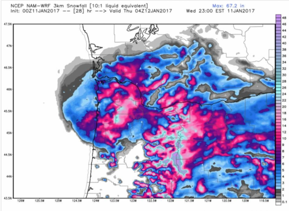
Such a great and dynamic system, something that seemed to be mostly missed on the global models but at least hinted at by the mesoscale models in the day or two before it happened. Don't remember the Euro, GFS or GEM ever really going too crazy with the snowfall amounts ahead of this but the 3km NAM, RGEM, etc were hinting at something much more explosive.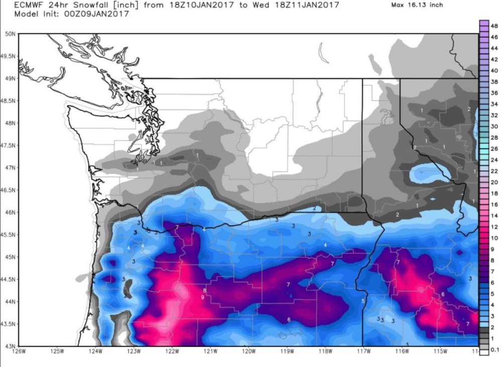
-
January 2024 Weather in the PNW (Part II)
Perturbed Member replied to Meatyorologist's topic in West of the Rockies
Weather.com now 2-4 inches for PDX down from 12--15+ inches a day or two ago. Picking up that southward trend. -
January 2024 Weather in the PNW (Part II)
Perturbed Member replied to Meatyorologist's topic in West of the Rockies
PDX sitting in a pretty good spot. Positioned well for any last second trek north. Hopefully low level cold and outflow from the gorge can help a bit with producing more lift. Any scenarios with rapidly strengthening lows racing off to the north should be off the table now. I have my doubts we'll see any huge snow totals but I suspect it could be a pretty nice event here with some snow, maybe some ZR in there too and very cold for days. Ending up totally dry is still possible but I just have a gut feeling at least some moisture will find a way up here. -
January 2024 Weather in the PNW (Part II)
Perturbed Member replied to Meatyorologist's topic in West of the Rockies
33.8F and sticking to even the roads due to the precip rates. Radar is looking pretty good still. -
January 2024 Weather in the PNW (Part II)
Perturbed Member replied to Meatyorologist's topic in West of the Rockies
34.9F and all snow. Gotta love what you can do with these kind of precip rates and a flat gradient. -
January 2024 Weather in the PNW (Part II)
Perturbed Member replied to Meatyorologist's topic in West of the Rockies
36.4F and rain snow mix here. Impressive precip rates. -
January 2024 Weather in the PNW (Part II)
Perturbed Member replied to Meatyorologist's topic in West of the Rockies
This track on the 18z Euro should be pretty similar to last night's Euro/ICON/UKMET camp, which is also about the same as what the GraphCast shows. Pretty far south with NW OR/SW WA at the northern edge of the main precip shield. -
January 2024 Weather in the PNW (Part II)
Perturbed Member replied to Meatyorologist's topic in West of the Rockies
I would be pretty impressed if we manage a widespread 1 inch, especially downtown. The 18z GFS is completely coked out but even these Euro snow maps are almost always too generous with 33-34F snow. Should be lots of heavy big wet snowflakes falling though.


