Perturbed Member
-
Posts
5085 -
Joined
-
Last visited
-
Days Won
2
Everything posted by Perturbed Member
-

January 2024 Weather in the PNW (Part II)
Perturbed Member replied to Meatyorologist's topic in West of the Rockies
18z GRAF. Looks like it sobered up. Doesn't matter too much though, I think we have a pretty decent idea of the range of possibilities tonight. -
January 2024 Weather in the PNW (Part II)
Perturbed Member replied to Meatyorologist's topic in West of the Rockies
Not sure if this was already posted but the 12z GraphCast continues to look...the same? SW WA/NW OR is on the northern edge.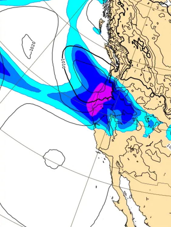
-
January 2024 Weather in the PNW (Part II)
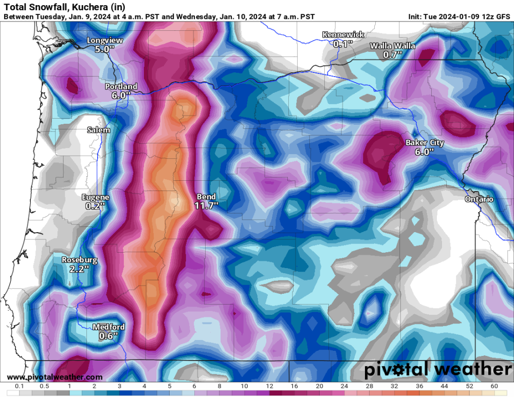
Perturbed Member replied to Meatyorologist's topic in West of the Rockies
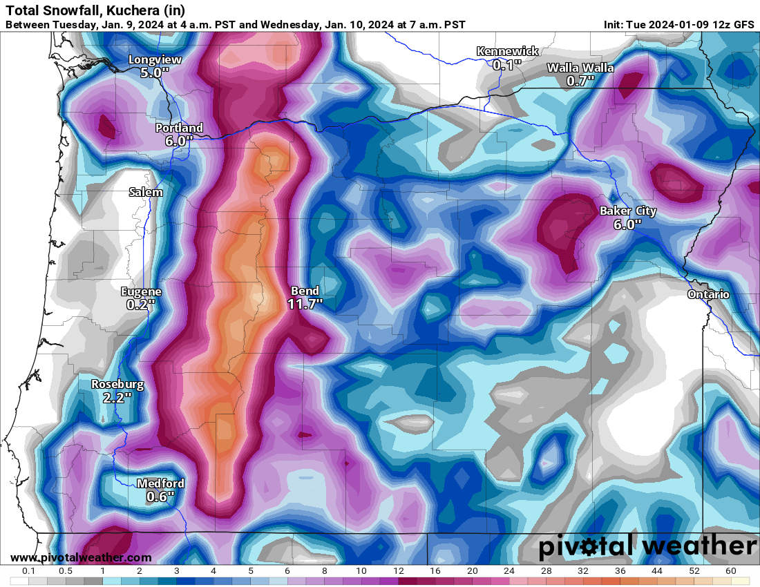
GFS going pretty nuts with the precip rates tonight. Gonna be absolutely dumping massive wet flakes. Very unlikely to get widespread 4-6 inch totals as shown here but could see some really hefty totals in the hills.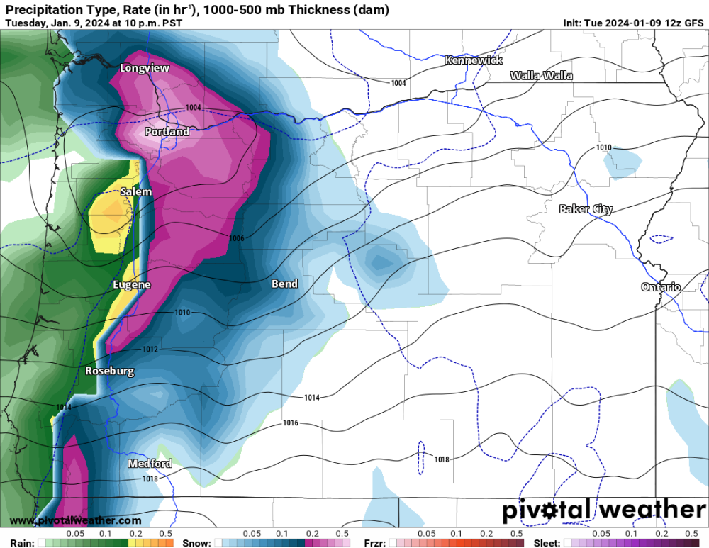
-
January 2024 Weather in the PNW (Part II)
Perturbed Member replied to Meatyorologist's topic in West of the Rockies
Yeah fair point on the HQ moving. I used to work with a guy who was an ex engineer at Boeing and he just had nothing positive to say about the culture change there after the Boeing-MD merger and I've heard similar sentiment from others previously at Boeing too. Not sure how true it really is but MD seems to have a pretty bad rep. Maybe some of that bias against them also comes from the DC-10 aircraft aka Death Cruiser 10 that they initially half assed. They eventually fixed the plane but the reputation was pretty slow to recover. The 737 Max is pretty much the new era DC-10. -
January 2024 Weather in the PNW (Part II)
Perturbed Member replied to Meatyorologist's topic in West of the Rockies
Pretty sad to see what happened to Boeing ever since they merged with McDonnell Douglas. The 737 airframe should have been retired long ago in favor of either a new from the ground up design or something based on the 757. The bean counters didn't like that though. Aviation is the wrong place for shoddy construction, corner cutting and half assery. -
January 2024 Weather in the PNW (Part II)
Perturbed Member replied to Meatyorologist's topic in West of the Rockies
Weather.com/IBM Weather getting colder here. Keeps PDX below freezing Friday night into Tuesday afternoon. Increased the snow totals too.
-
January 2024 Weather in the PNW (Part II)
Perturbed Member replied to Meatyorologist's topic in West of the Rockies
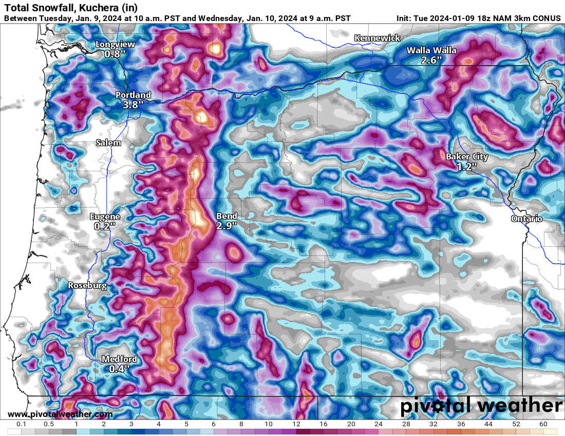
18z 3km NAM for tonight
-
January 2024 Weather in the PNW (Part II)
Perturbed Member replied to Meatyorologist's topic in West of the Rockies
Agree that the precip shield usually extends further north than modeled. That seems to very often be the case. Did the precip make it up to Tacoma in Feb 2014? I thought at least OLM had some light accumulations. -
January 2024 Weather in the PNW (Part II)
Perturbed Member replied to Meatyorologist's topic in West of the Rockies
Even with things being so suppressed, there will be more surprise sources of precip as we get closer. Some of those surface lows for Feb 2014 didn't show up on the models until very short range. Getting that deep cold air in place is much more important than finding moisture. It looked pretty much over for the Willamette valley yesterday, but it looks like they could be back in the running now. -
January 2024 Weather in the PNW (Part II)
Perturbed Member replied to Meatyorologist's topic in West of the Rockies
We've come full circle now, several days ago the models were mostly all showing this energy heading into California. Looks like the euro wants to go back to that. -
January 2024 Weather in the PNW (Part II)
Perturbed Member replied to Meatyorologist's topic in West of the Rockies
So the 12z UKMET and 06z ICON may have been onto something after all. The ICON ended up coming back up a bit more north for the 12z but these far south solutions seem to be a possibility now. The EPS 06z had a fair number of members taking things way south. -
January 2024 Weather in the PNW (Part II)
Perturbed Member replied to Meatyorologist's topic in West of the Rockies
12z Euro tonight
-
January 2024 Weather in the PNW (Part II)
Perturbed Member replied to Meatyorologist's topic in West of the Rockies
It appears to have pulled a 06z ICON and went way south from its 00z run. 12z vs 00z -
January 2024 Weather in the PNW (Part II)
Perturbed Member replied to Meatyorologist's topic in West of the Rockies
06z NAM now within range of the Friday event. Seems south of GFS but north of the Euro and others. Starts out as snow in PDX and North WV. -
January 2024 Weather in the PNW (Part II)
Perturbed Member replied to Meatyorologist's topic in West of the Rockies
Lost power here briefly. -
January 2024 Weather in the PNW (Part II)
Perturbed Member replied to Meatyorologist's topic in West of the Rockies
Probably a good thing, better to give up some precip and be on the cooler side of things. -
January 2024 Weather in the PNW (Part II)
Perturbed Member replied to Meatyorologist's topic in West of the Rockies
Yeah some solid improvements in the models for us tonight. Probably pretty good odds of getting a legit snow and ice storm, maybe more snow than ice. I get the impression that the GFS will shift more towards the others than the other way around. Who knows though, I thought the GFS would completely cave to the Euro the past 2 days and that didn't happen. -
January 2024 Weather in the PNW (Part II)
Perturbed Member replied to Meatyorologist's topic in West of the Rockies
Taking a look at all the 00z runs for the weekend. The ICON, UKMET and Euro are team suppressed and cold, there is actually very good agreement between these 3. GFS is very progressive and spreads precip way north and the GEM tries to strike some kind of balance between the others and the GFS. -
January 2024 Weather in the PNW (Part II)
Perturbed Member replied to Meatyorologist's topic in West of the Rockies
00z vs 12z Euro for the weekend. It actually seems to drastically reduce the precip down the valley. Not a dramatic reduction for PDX though and the northern extent of the precip hasn't changed too much here either. -
January 2024 Weather in the PNW (Part II)
Perturbed Member replied to Meatyorologist's topic in West of the Rockies
12z vs 00z Euro. Look how much faster the cold gets into the Columbia basin. -
January 2024 Weather in the PNW (Part II)
Perturbed Member replied to Meatyorologist's topic in West of the Rockies
Don't think this track could look much better for PDX. With how dynamic that feature is, would be fun to have the precip rates absolutely explode over us. There is probably going to be at least some isolated spot or two with significant accumulations from this. I don't really buy the widespread 2-3 inch thing the Euro snow map is showing though. That map is often bs when the temp is that marginal. -
January 2024 Weather in the PNW (Part II)
Perturbed Member replied to Meatyorologist's topic in West of the Rockies
UKMET precip for the weekend event 12z and 00z. Compare to the 12z Euro and then the 00z GFS and 00z GEM. Euro and UKMET are much more suppressed. GFS is the GFS and GEM is in between as far as how far north the precip goes but it goes full AR. -
January 2024 Weather in the PNW (Part II)
Perturbed Member replied to Meatyorologist's topic in West of the Rockies
UKMET for tomorrow Weekend -
January 2024 Weather in the PNW (Part II)
Perturbed Member replied to Meatyorologist's topic in West of the Rockies
I'll be pretty happy with the 00z suite if the ECMWF can just hold steady and not cede anymore to the GFS. Getting snow is great but having prolonged cold after the weekend would be really nice if it could somehow be done. I'm kind of skeptical that we can have this massive overrunning event and then remain that cold for days after but I certainly would enjoy that. -
January 2024 Weather in the PNW (Part II)
Perturbed Member replied to Meatyorologist's topic in West of the Rockies
Yeah I think you guys are in a really good spot. Either a huge snowstorm or if things do stay further south, lighter snow totals but stay colder and for longer. Not the worst outcomes to have on the table.