

Perturbed Member
-
Posts
5085 -
Joined
-
Last visited
-
Days Won
2
Everything posted by Perturbed Member
-

January 2024 Weather in the PNW (Part II)
Perturbed Member replied to Meatyorologist's topic in West of the Rockies
12z vs 00z GEM. A small shift north. -
January 2024 Weather in the PNW (Part II)
Perturbed Member replied to Meatyorologist's topic in West of the Rockies
18z EPS Friday night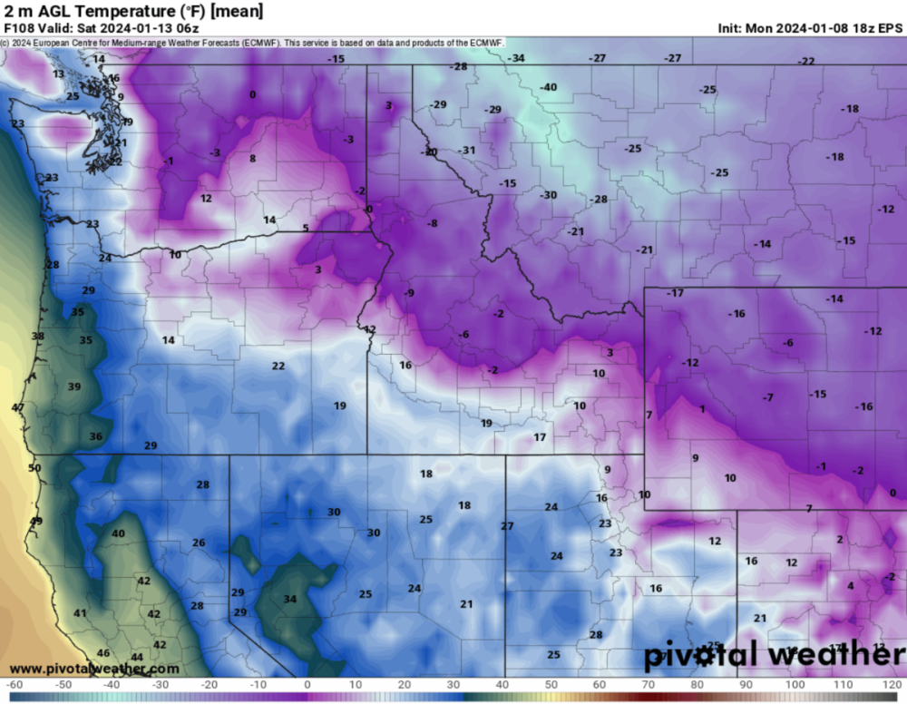
-
January 2024 Weather in the PNW (Part II)
Perturbed Member replied to Meatyorologist's topic in West of the Rockies
Hopefully this translates into something meaningful tomorrow night. The Euro has been pretty consistent in showing snow in PDX Tuesday night. The 18z run looks pretty decent. -
January 2024 Weather in the PNW (Part II)
Perturbed Member replied to Meatyorologist's topic in West of the Rockies
18z Euro tomorrow night
-
January 2024 Weather in the PNW (Part II)
Perturbed Member replied to Meatyorologist's topic in West of the Rockies
I thought the Euro had this arctic blast all planned out for us but then the GFS showed up and just punched it in the mouth. Still waiting to see if the Euro gets any wins here in the next 48 hours or if the GFS is going to continue to body up the Euro. -
January 2024 Weather in the PNW (Part II)
Perturbed Member replied to Meatyorologist's topic in West of the Rockies
Looks like the 18z GFS doesn't even want to give us low level CAA. PDX stays in the 40s mostly with the valley further south approaching 50. Gets into the mid 30s briefly in PDX and that's it. Pretty amazing how hard this fell apart. -
January 2024 Weather in the PNW (Part II)
Perturbed Member replied to Meatyorologist's topic in West of the Rockies
18z GRAF Hopefully this comes at least close to verifying tomorrow. Throw SLE-PDX a bone. Getting pretty desperate here -
January 2024 Weather in the PNW (Part II)
Perturbed Member replied to Meatyorologist's topic in West of the Rockies
Jokes aside, I really think tomorrow night might actually be it down here in terms of snow. Friday-Saturday isn't far from just turning into a ZR to rain event. -
January 2024 Weather in the PNW (Part II)
Perturbed Member replied to Meatyorologist's topic in West of the Rockies
This is pretty much the dream scenario for PDX. Colder and more suppressed. PDX on the northern edge of the precip. -
January 2024 Weather in the PNW (Part II)
Perturbed Member replied to Meatyorologist's topic in West of the Rockies
Yeah I guess the warming aloft on the Euro looks fairly modest and probably manageable as it is shown on the 12z. My concern is more about a continued northward trend. Another notch or two further north and that cross section looks much uglier. Hopefully no more drastic changes. -
January 2024 Weather in the PNW (Part II)
Perturbed Member replied to Meatyorologist's topic in West of the Rockies
Yeah the potential for a big snowstorm or winter storm of some kind is very much there but we still have a few days to go for this and we can't really afford for this to trend any further north if we want decent snow. The Euro has shifted things 100s of miles north in the past 18 hours alone. The cold and suppressed team is giving up a lot of ground and there is still a bit more time to go. These systems are more likely to come in further north than south. Good for the folks further north but it will probably be at our expense. It is also possible though that we have mostly come into model consensus and there won't be as many big shifts from here on out. For now I will pretend that this current forecast for Portland is what we will get
-
January 2024 Weather in the PNW (Part II)
Perturbed Member replied to Meatyorologist's topic in West of the Rockies
Yeah I am hoping the upper levels will hold on better than modeled. We don't need that kind of ice damage again in the valley... -
January 2024 Weather in the PNW (Part II)
Perturbed Member replied to Meatyorologist's topic in West of the Rockies
Thinking the surface temps being cold here Friday-Sunday is probably a lock as long as the cold gets delivered to the Columbia basin. Arctic front or not, the backdoor will bring in the cold via the gorge and keep it there for a while. This is of course assuming that system doesn't go full GFS and go way north. Not loving how much WAA is happening here though. Lot of the precip used up as ZR. The 850s don't stay below freezing too long. Last 2 Euro runs show a kind of fun snow to zr and then back to snow again as the 850s cool and the low sinks south. Classic battle of the airmasses. -
January 2024 Weather in the PNW (Part II)
Perturbed Member replied to Meatyorologist's topic in West of the Rockies
Good catch, crazy to see that level of uncertainty in the ensembles at short range. A bit encouraging to see the OP run was way above the average or control. -
January 2024 Weather in the PNW (Part II)
Perturbed Member replied to Meatyorologist's topic in West of the Rockies
The 12z GFS is a cruel joke down here. The arctic front doesn't really even make it to Olympia let alone PDX. There are plenty of other models that produce a decent outcome here but hard to ignore the GFS completely when it has been leading the way. Hopefully the 12z Euro doesn't screw us completely. -
January 2024 Weather in the PNW (Part II)
Perturbed Member replied to Meatyorologist's topic in West of the Rockies
It is an improvement over the 00z GFS. I guess that's a start. Still hot garbage down here though. Just a bunch of nasty ZR. -
January 2024 Weather in the PNW (Part II)
Perturbed Member replied to Meatyorologist's topic in West of the Rockies
Yeah it is a pretty dynamic feature. If things come together just right for someone on the north side of it, no reason why you couldn't get a quick heavy wet snow fall with several inches. It won't be a very widespread area of course. -
January 2024 Weather in the PNW (Part II)
Perturbed Member replied to Meatyorologist's topic in West of the Rockies
3km NAM 06Z -
January 2024 Weather in the PNW (Part II)
Perturbed Member replied to Meatyorologist's topic in West of the Rockies
The trend is now getting picked up on Weather.com model too. Less cold air makes it down, but closer to the moisture and the cold vs warm battle zone. Increased snowfall forecast but higher temps. A dangerous game to play where you gamble and often end up with 38F, rain and a SW wind.
-
January 2024 Weather in the PNW (Part II)
Perturbed Member replied to Meatyorologist's topic in West of the Rockies
At this point I am hoping Tuesday night produces results down here. On paper what the Euro shows for Saturday does work out for many of us but it is just one more nod towards the GFS away from being a total nonevent. The 12z Euro had this low coming in at the OR/CA border and it shifted it up like 250 miles on the 00z. It turns out the weather is not in fact a function of the Euro's output. -
January 2024 Weather in the PNW (Part II)
Perturbed Member replied to Meatyorologist's topic in West of the Rockies
Too bad the warming aloft is so rapid, just like on the UKMET. 850s cool off again later Saturday and it changes back to snow though -
January 2024 Weather in the PNW (Part II)
Perturbed Member replied to Meatyorologist's topic in West of the Rockies
What a joke. 12z vs 00z Euro. -
January 2024 Weather in the PNW (Part II)
Perturbed Member replied to Meatyorologist's topic in West of the Rockies
The rogue GFS has beheaded the king. The king is dead! -
January 2024 Weather in the PNW (Part II)
Perturbed Member replied to Meatyorologist's topic in West of the Rockies
Tuesday night on 00z Euro. Still trying to show a little mercy to PDX.


