


Niko
-
Posts
12450 -
Joined
-
Last visited
-
Days Won
21
Everything posted by Niko
-
Gorgeous evening out there. Some left over snowshowers remaining, but yes..you just wanna be outside in the snow.
-
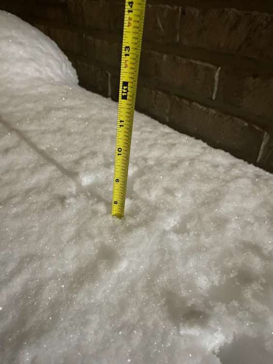
My total snowfall is 7.5" and was very satisfied w/ this snowstorm.
-
Its a winter wonderland! Lets add on the next one!! Going to measure soon!
-
Macomb looks like it will avoid the dry slot, thankfully. Detroit looks like its filling up again. Everything outside looks so beautiful. Deep snow as well.
-
Going for measurements later tanite. Still moderate snow here. Heavy at times. Backside snows are pushing in soon. Should rap up by 8pm or 9. Cant wait to take pics and post them.
-
Heavy snow falling attm....accumulations in mby 5" or so. The beauty of all of this is that its a full blown daytime major snowstorm.
-
Impressive, considering how far away you are from the center of this. Also, I still can believe how perfect of a track this is. Its 100% perfection. Sweet!
-
@Ferndale_man@jaster220how much snow have ya picked up so far?!
-
Attm, I am at 4" here and puking snow out there.
-
Zero! Thanks to the raging sun yesterday and upper 30s melted my snowcover. For the season, Detroit is ranking at 11.0" It will be real funny after a really mild month, if January ends up being above normal in the snow dept.
-
Also, can you imagine w/ all the other snowmakers coming and along with that frigid air as well. It will look like a frozen "Tundra" here in our neck of the woods and also for our other members on here as well.
-
Its sticking everywhere. Temp @ 32F. Its a mess out there. Beautiful scenery, especially seeing the snow come down so heavy. Its been awhile since I saw it snow this hard.
-
It looks like over 3" so far imby and counting. This heavy snow band really boosted the amounts.
-
Yes..heavy snow here as well. Puking snow out there w/ visibilities less than a 0.25 of a mile. This heavy band accumulated so fast. I will take pics after the storm.
-
It is really coming down now. Heavy snow as we speak. Speaking of sledding, I was actually thinking about it for later today, if time permits. Snowblower in full gear later tanite, if it ends at 10pm.
-
It was only a matter of time until they upgraded us to a WSW. You even mentioned it to me yesterday that it will most likely happen.
-
Radar looks beautiful. Snowing moderately now and heavy snow is on the move for later this afternoon.
-
Look at what is coming later this afternoon.....
-
Just by eyeballing it, I am most likely near 2" attm. The heavy stuff is yet to come.
-
@tStacshLooks like you are going to do a lot better than what was anticipated earlier on. Definitely a more NW movement of this major storm. Good call!
-
So far I have picked up 1.7" and puking snow is still later on. Its looking real great!!
-
Ikr....we are getting into a very active, snowy pattern and most importantly, a frigid one coming up down the road.
-
NOAA: On a broad scale the system looks really good. A deep upper level trough is carved out through the Plains with a 140 knot jet rounding the trough tonight and turning up toward the eastern Lakes and directing a strong mid level wave into the lower Great Lakes. A slowly strengthening surface low will track up through Ohio and western Lake Erie this evening keeping SE MI in the favorable nw quadrant of snowfall production. Upper level diffluence will be overhead with a coupled jet, as well as a secondary shortwave dropping into the trough which should keep the lead wave from becoming too progressive by introducing height falls to the west. The track of the surface low to the west of Cleveland lifting into the Ontario Peninsula has become the consensus and changed little over the last 24 hours. This is an ideal track to bring the deformation axis and trowal across SE MI. The system will have good moisture as it was over the deep south yesterday with moisture feed from the Gulf of Mexico. PWATs will rise to around a half inch with specific humidities at least 2-3 g/Kg and potentially up to 4. Soundings show saturation up through about 550 mb which encompasses the DGZ which is centered around 600mb which good omega in that region. Weather pattern will remain active through the upcoming week as we remain near the base of the longwave trough which will steer a train of shortwaves through/near the region. The first wave will be centered to the north over Ontario but the trough will swing through lower MI bringing a chance of snowfall Friday Night. The second, possibly more impactful, system will track along a baroclinic zone draped across southern MI Saturday night through Sunday. This would be a longer duration event as the main boundary moves very little and the shearing out wave rides right along it overhead. Additional waves may affect the area Monday and Wednesday.
-
I agree...I am seeing some potentially 10"+ for some locales w/ this storm. Surprises are certainly possible w/ this major snowstorm. Btw: Great pics this morning from ur neck of the woods.
-
Upgraded to WSW Finally!!!! Winter Storm Warning URGENT - WINTER WEATHER MESSAGE National Weather Service Detroit/Pontiac MI 353 AM EST Wed Jan 25 2023 MIZ069-070-075-252100- /O.UPG.KDTX.WW.Y.0001.230125T1200Z-230126T0300Z/ /O.EXA.KDTX.WS.W.0001.230125T1000Z-230126T0100Z/ Oakland-Macomb-Washtenaw- Including the cities of Pontiac, Warren, and Ann Arbor 353 AM EST Wed Jan 25 2023 ...WINTER STORM WARNING IN EFFECT UNTIL 8 PM EST THIS EVENING... * WHAT...Heavy snow expected. Total snow accumulations of 6 to 8 inches. * WHERE...Oakland, Macomb and Washtenaw Counties. * WHEN...Until 8 PM EST this evening. * IMPACTS...Travel could be very difficult. The hazardous conditions could impact the morning or evening commute. * ADDITIONAL DETAILS...A narrow band of light snow has lifted into southern Michigan as of 4am. There may be minor accumulations with this lead band which could lead to hazardous conditions during the morning peak travel period. Snow will then steadily increase in coverage and intensity with the peak of the heaviest snowfall rates between 10 AM and 4 PM Wednesday. Travel conditions will deteriorate considerably during the afternoon into the evening commute.


