

Timmy Supercell
-
Posts
7757 -
Joined
-
Last visited
-
Days Won
14
Posts posted by Timmy Supercell
-
-
I hope some of those clusters/QLCS's go into eastern KY. The last one just about died going over I-75.
Not asking for a 4/2 repeat as that one was slightly scary. But....

-
16 hours ago, Hawkeye said:
Euro ensemble avg next 15 days. That is what I want.... warm, stormy, wet.
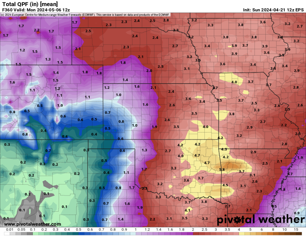
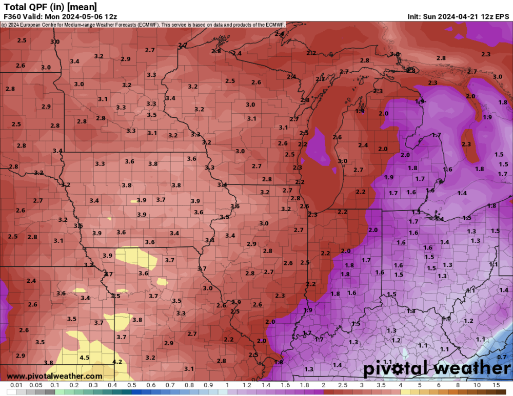
While I want Charleston WV to dry out, I think my place can handle a little more than 1".
Bring on the storms!!
-
 1
1
-
-
We got to 29 this morning! Think the forecast was for 35. Not bad.
-
 3
3
-
-
Had 65/43 yesterday, and another low of 42 this morning. I'm really soaking up these crisp days while they last.
End of April has another "heatwave" showing but hopefully coming with more t'storm chances.
-
2
-
-
It was a matter of time before my luck ran dry. Still don't think I ended up with any t'storm with this latest event.
Might as well just assume a lot of them past I-75 break apart and become light showers with the events that bullseye around Paducah. Sometimes locations directly south of me will still get a storm and not me. I've seen I-64 also act as a weather barrier at times.
-
They promise Wednesday provides the best convection in this area but so far I am not convinced.
Everything that moves into Kentucky has looked like light rain/debris from dying storms.
-
The storms don't like eastern Kentucky these last couple days.

-
 2
2
-
-
50 minutes ago, Hawkeye said:
As expected, overnight was a total bust. Strong east wind is pumping very dry air into eastern Iowa. On top of that, the entire area is covered in thick clouds. At this point I'm hoping we can get a half inch of rain.

I was surprised at how many areas were either capped or just didn't have a strong trigger, it was my warmest day of the year so far. We got to 86 and had little to no cool off until middle of the night.
-
1
-
-
17 hours ago, Timmy Supercell said:
This is quite a development. Last night it was a generic t'storm risk almost not including my area.

They later reverted back to a marginal for all of KY, and last night nothing developed in the Jackson CWA..
There were a couple severe warned storms south and east of Louisville and something way up in northern WV before those.
-
1
-
-
This is quite a development. Last night it was a generic t'storm risk almost not including my area.
-
5
-
-
An overperformer I see.. got to 84 for a high. The forecast was 80-81 on a couple sources.
77 right now, with some light winds continuing but not as strong as they were this afternoon.
-
2
-
 1
1
-
-
59 and calm mid Spring evening. The wind finally died down, can't ask for a better evening for the time of year. High was 66 with WNW gusts to 20mph earlier.
Tomorrow is a high of 80! Can't remember if I already hit 80 once this year but we've gotten within a degree or two of that a few times for sure without checking..
-
1
-
-
It took 10 days to get this station back up and running..

-
1
-
-
1 minute ago, SilverFallsAndrew said:
Cedar Breaks, UT
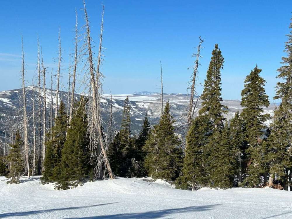
Now that's a sight. Come across any marmots? They love high places.

-
1
-
 1
1
-
-
6 minutes ago, Omegaraptor said:
Late July? Very long heat wave happened then. One day I saw it rain with temps in the mid-90s in Tigard which is probably some of the most un-PNWlike weather I’ve seen in the PNW.
If that rain came with a chance of t'storms that used to happen more as a kid. More recently it looks like summer time storms are more of a east side thing.
And yeah, late July sounds right for that heatwave in 2022. I left there in Nov '21 but I still have a couple family members there that tell me some things. Apparently December and April was their winter, but not much snow fell between those months. Late winter seems to be all or nothing for them these last few years. It's a contrast to ones like 2011, 2012, or 2017 that had more consistent periods of snow.
-
1
-
-
1 hour ago, the_convergence_zone said:
Sign me up for a 2022 repeat…just not the part at the end of summer.
lol I recall there being another rare stretch of 100's at KLMT that year, 5 days in a row? It's hard to get just one of them there.
After 2013, there wasn't another 100+ until June of 2021.
-
1
-
-
12 hours ago, Phil said:
Seems when you score I get shafted and vice versa.
 I’ve been seeing flashes of lightning for the last 90 mins and there’s a bowing line of storms approaching from the southwest. Feels like an over-performer incoming.
Another pattern too I've noticed is usually when the increasing dynamics "start" around these counties I can get shafted in those. When Louisville/Lexington are in the thick and also includes me, I score the better ones. I need already matured and organized convection reaching those points before they get to Boyd County.
Still, probably shouldn't be bummed at not getting a thunder, I've had quite a high number of them for this time of year. If they continue on a weekly basis this summer, I might get to 60 of them for 2024

-
1
-
-
3 hours ago, Phil said:
Yeah lots of precip and crapvection in the warm sector ahead of strongest forcing.
But these high shear/low CAPE setups can overperform unexpectedly, and at the last possible minute. February 2016 and March 2008 looked like nothingburgers out here, but both ended up mixing out the low level inversion and producing QLCS’s with hurricane force winds and spinups.
Looks like my dome is back, not one single rumble of thunder all day, but I see a report of a tree down in Ironton just a town over from me.
-
1
-
-
19 minutes ago, Phil said:
Speaking of tornadoes, I noticed @Timmy Supercell is under another watch.
Keep a watchful eye on this collision between the cold front and warm-sector thunderstorm outflow. 80% of the time nothing comes of it, but if something does, it’s a pretty dangerous environment.

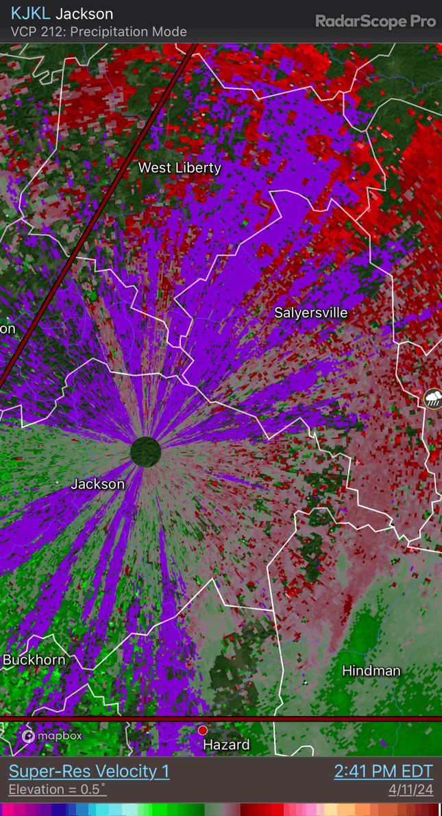
So far this one is nowhere near as wild as the last one at least on first impression.
I think the flooding from training storms, and a wind threat from a QLCS are the highlights. I would've opted for a Severe T'storm Watch for most of the areas in the TOR right now. Prove me wrong though!
-
1
-
 1
1
-
-
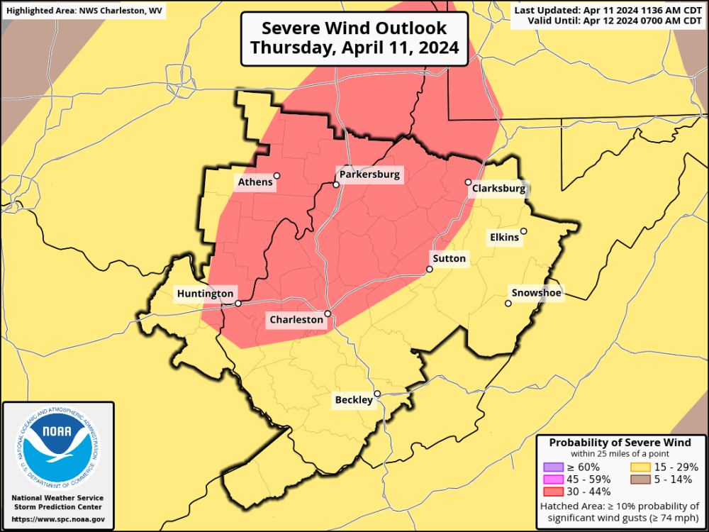
They upgraded the wind category, and this area also includes me but barely..
-
2
-
 1
1
-
-
It's been on/off raining most of today, they were expecting a mid day clearing and a few supercells forming in eastern KY.
Maybe it doesn't take much to get them going sometimes. 68-69 degrees and rain still coming down at almost 1pm.
-
1
-
-
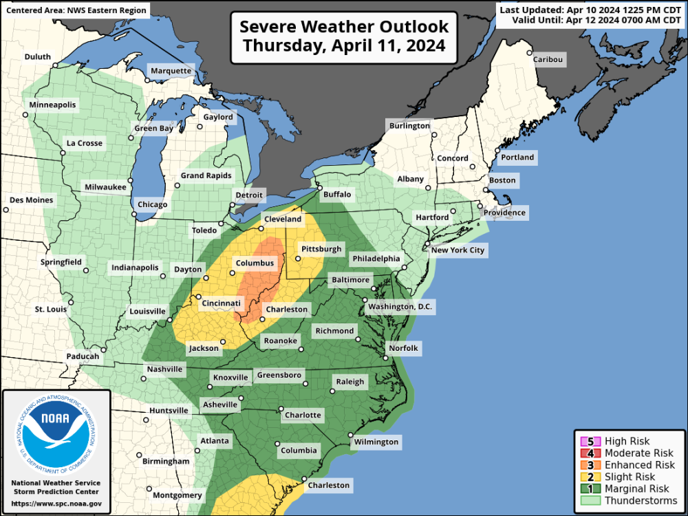
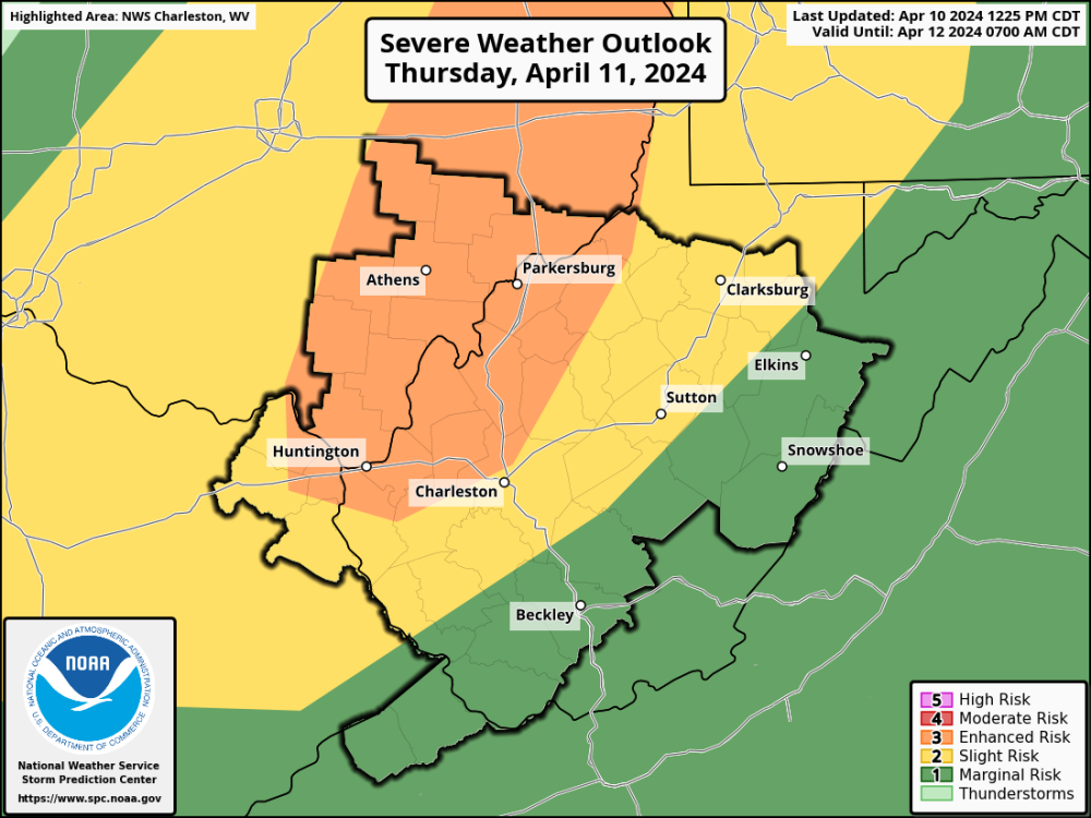
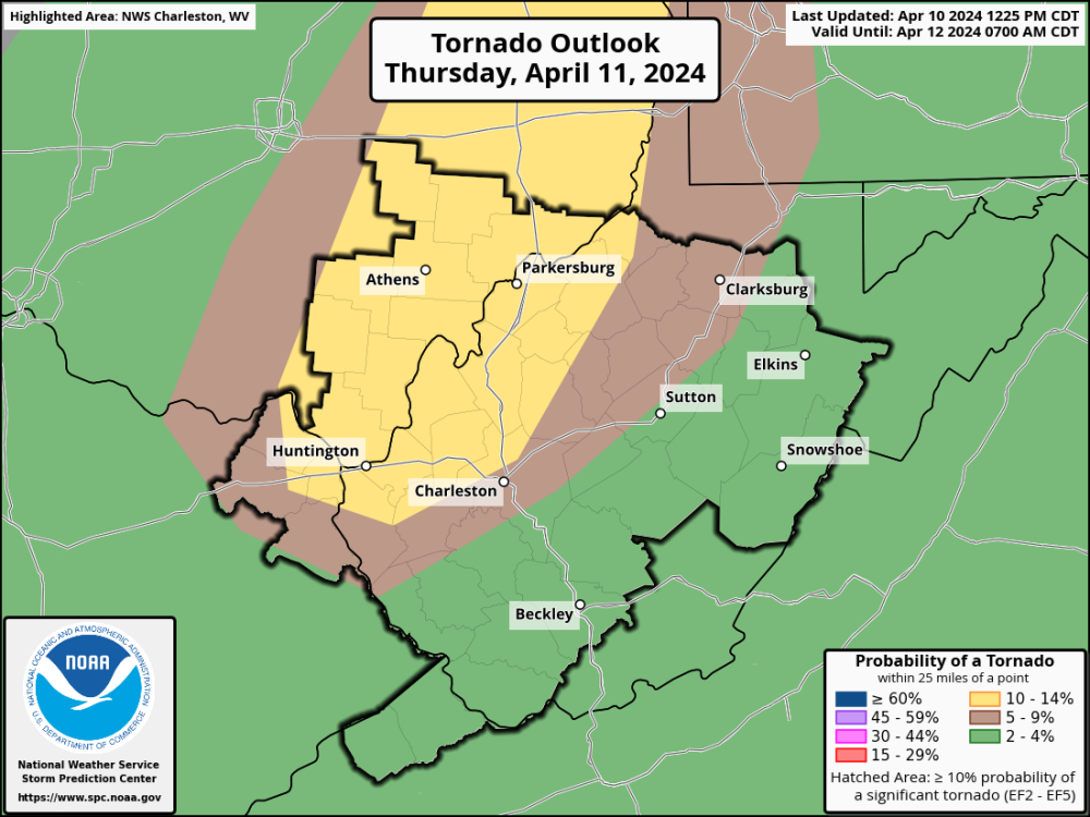
Here we go again! SPC placed an Enhanced Risk for tomorrow starting around Boyd/Greenup Counties in NE KY area extending to the eastern Ohio border. Originally this was just a Slight Risk for the entire area.
-
2
-
-
Awesome cloudy day in the upper 60's, sun hasn't peeked out once.
Since Ashland Regional is still down, I'm looking at Huntington for observations (usually not too far off our wx except for in some heavy rainfall events). They got to a high of 66 with 0.21" precip. I probably wouldn't call today awesome if it was 40 degrees. I think my pacific northwest buddies would enjoy a milder feeling overcast day over here.
-
1
-
-
3 hours ago, Phil said:
You know the cold season is on its deathbed when it’s pushing 80°F despite mostly cloudy skies.
Might’ve had our last sub-60°F high until Oct/Nov.
Yup we were low 70's this afternoon with maybe a few minutes of filtered sunshine.
Even the low temperatures have taken a turn recently.
-
 1
1
-
 1
1
-


April 24-29 Multi Day Central and Southern Plains Severe Weather Outbreak
in East of the Rockies
Posted
Pi-Day event had its interesting parts. Before the main bout of supercells in IN/OH, there was one lonely supercell that travelled from near Cincinatti all the way to my vicinity a few hours prior, with nothing else picking up on JKL radar around that time.
Then all the later night storms developed into an MCS hitting me around 2am.
Overall the Feb 28 and April 2 events gave me much more of a uh-oh feeling in the gut. Pi-Day had a ton of large hailers, and a few storms that happened to hold together a stronger tornado. Not to say 3/14 wasn't a good one though, Ohio was a surprise during that one as they weren't exactly bullzeyed at first.