

Timmy Supercell
-
Posts
7775 -
Joined
-
Last visited
-
Days Won
14
Posts posted by Timmy Supercell
-
-
58 minutes ago, mlgamer said:
So here ya go...our first snowfall of the season in November was more than all of last winter...which wasn't all that hard to beat...

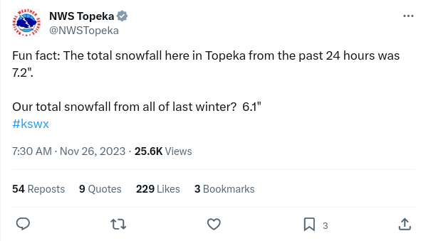
That 6.1" from last winter is 10x what I had in all of that winter.
Funny though, I had a lot of days flakes fell but it was fake snow.
-
 1
1
-
 1
1
-
-
There may be some "air flakes" next couple nights here in Ashland. NWS doesn't seem too confident on sticking snow in the lowlands, but accumulation on the mountains are not ruled out.
-
 1
1
-
 1
1
-
-
The next 2 days will be very cold! Average high is maybe 50 right now? 37-39 Mon/Tue..

-
 3
3
-
-
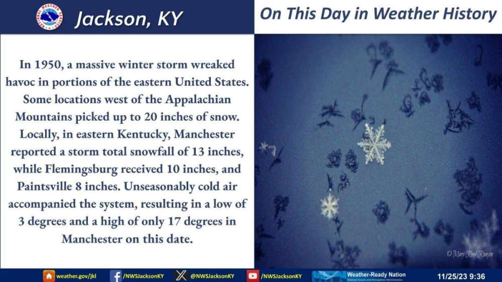
I hardly consider November part of winter here. But on this day in 1950..

-
5
-
-
28 for a low this morning. Sun is out and not a cloud seen.
Some rain arriving tomorrow, probably not much.
-
2
-
-
These are gnarly. The one by Natches, MS might have some big hail in it.
.gif.ac9160128363f19c0ace5e37d0e7ae73.gif)
-
 1
1
-
1
-
-
So, either this upcoming "cooldown" got warmer or is simply moved back a few days.. The 40's are now at the end of November here.
-
Not sure if this was posted here yet.

-
1
-
2
-
-
15 minutes ago, Hawkeye said:
The party is over after this weekend. Mid next week will be a big slap to the face.
Wunderground is showing that here!
-
Yesterday was an impressive 45 degree spread from low to high. 72/27!
Reminds me what we would get more often on the east slopes of the Cascades.
-
1
-
1
-
1
-
-
On 11/15/2023 at 7:28 AM, westMJim said:
The official H/L yesterday at Grand Rapids was 57/27 there was no rain or snow fall. There was 100% of possible sunshine. The highest wind gust was 18 MPH out of the SE. For today the average H/L is 47/33 the record high of 68 was set in 1990 and the record low of 10 was set in 1933. The wettest was 1.84” in 1989 of that there was 1.6” of snow. The most snow fall for the day was 4.1” in 1969 the most on the ground was 5” in 1974. Last year the H/L was 33/28 and there was 3.2” of snow fall.
Michigan weather history for November 15th
1933: Michigan is in the grip of a four-day cold snap. The low of 10 degrees at Grand Rapids only rises to 18 degrees during the afternoon as lake effect snow showers swirl around and an icy northwest wind makes it feel even colder.
On November 15, 2018, a low-pressure system brought a rain and snow mix to far eastern Southeast Michigan while all snow occurred elsewhere. Snowfall totals of around 4.5 inches were observed in the Tri-Cities area while a general 1 to 3 inches fell elsewhere.
On November 15, 2005, a third powerful storm hit the area in just a week and a half during November 2005, leading to yet another round of strong winds. The cold front pushed through during the evening, leading to another period of strong winds, occurring through the early morning hours of November 16. Southwest winds were sustained at 25 to 35 mph, gusting to around 50 mph, with the exception of Huron County, where wind gusts were estimated near 60 mph. Trees were downed along the lakeshore from Caseville to Grindstone City. Heavy rains also occurred across the region, and the combination of winds and rain led to property damage estimated at 7.2 million dollars. One man was killed (indirect) and another injured (indirect) in a vehicle collision caused by a tree that had fallen into the road in Northern Oakland County due to the strong gusty winds.
On November 15, 2001, a mid-month storm brought winds of 40 and 50 mph and also brought the most rain in a day for the month with nearly 2.30″ in the Detroit area.
11/15/2005 produced a powerful F4 tornado in Madisonville, KY. And coincidentally on the same date in 1955 I'm reading about another F3 tornado not too far from where that occurred, in the Evansville area.
-
A chilly 27 this morning! Some outlying freezing fog reported, not much in downtown though. We haven't had a thick fog in some days.
-
1
-
2
-
-
I like these bigger diurnal changes in temperature, went from 29 to 64 in Ashland today!
-
1
-
-
22 minutes ago, fubario said:
Pretty sure there's only "one downside" if Yellowstone pops off. lol
There's other equally powerful ones, Yellowstone gets too much attention.
-
2
-
-
5 minutes ago, MossMan said:
Wasn’t 1950 or 69 but was still an awesome week!
KFalls had a pretty snowy week out of that one, but the winter was largely a dud if you count the following 2 months.
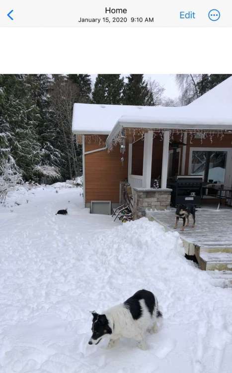
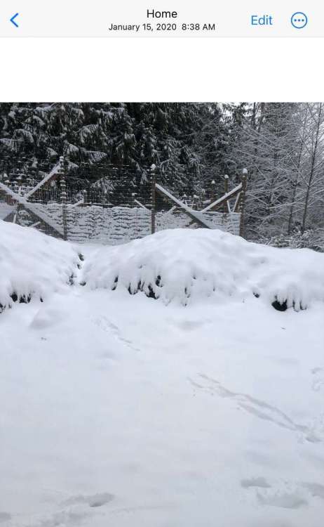
I had 18.5" from 1/9 to 1/16, locked horns with some 1 week snows from 2017 and 2012.
-
1
-
-
1 hour ago, TigerWoodsLibido said:
The family from Indiana is moving back here to Springfield so my family is stuck here. None of the rest of them like snow and cold sadly.
I bet they regularly have snow on the ground in mid winter up in Indiana.. it's much shorter lived just a bit to the south of them.
-
1
-
-
Hey whats this!? We got to 24 this morning. Not sure what the daily record is, I'll look it up.
-
2
-
-
54 minutes ago, Port Angeles Foothiller said:
I’ll be sure to let everyone know when that happens
I remember there being two times since 2017 that happened there. Maybe some localized amounts higher than others. Not sure.
-
7 minutes ago, TigerWoodsLibido said:
2-25-19
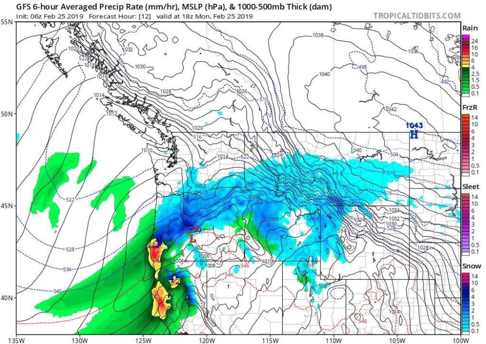

I miss Pelican Brewing, one of my go-to drinks when I was in K-Falls.
-
1
-
 1
1
-
-
3 minutes ago, Rubus Leucodermis said:
Port Angeles is the new Eugene.
Except for the times they get the odd 20" snowstorm in 1 day.

-
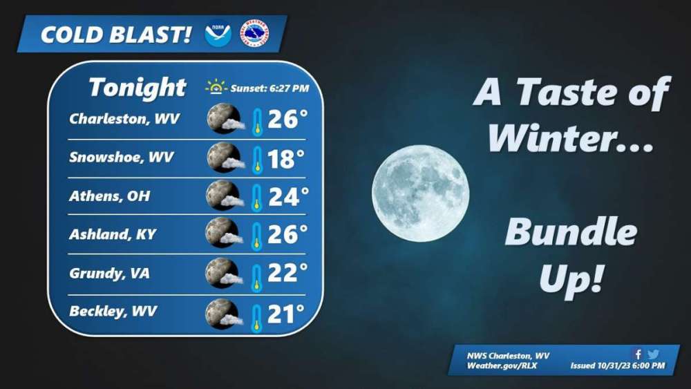
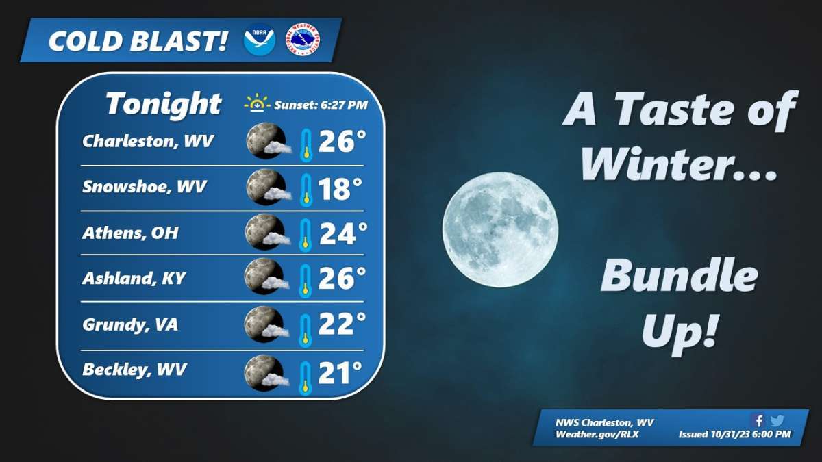
The graphic says yesterday but their FB page just posted this right before I did on here..

-
2
-
-
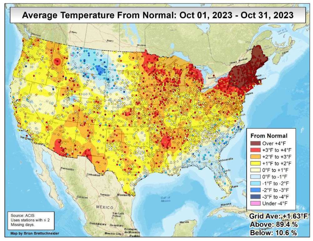
October 2022 actually ran cool I forgot, -3.6, and Oct 2021 was +6.3. lol
-
Another warm October here at my place but Oct 2021 has this one beat by a couple degrees..
-
1
-
 2
2
-
-
Officially got my first freeze this morning, though barely at 32 for the low.
We were supposed to be in the upper 20's. Tonight looks like another equally cold night. Maybe it'll be a degree or two cooler tonight if there is no wind activity.
-
1
-


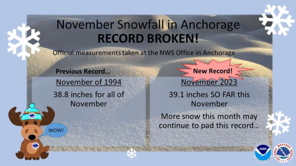
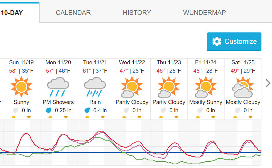
November 2023 Weather in the PNW
in West of the Rockies
Posted
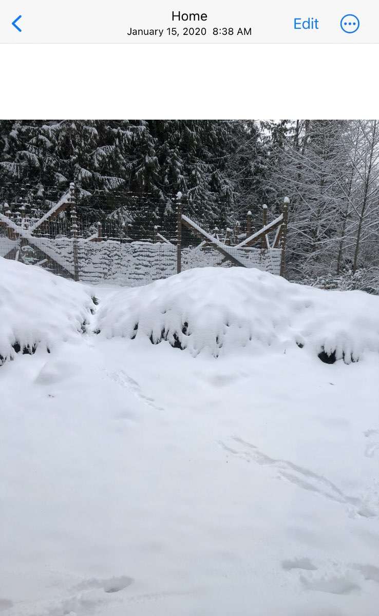
While the overall seasons are like that in the PNW, months like Dec 2015 and Feb-Mar 2019 in the mountains produced like a whole winter's worth of snowfall in one bang.
Also, I bet this winter in NE Kentucky here does more than last winter.")