

Timmy Supercell
-
Posts
7759 -
Joined
-
Last visited
-
Days Won
14
Posts posted by Timmy Supercell
-
-
70 and sun is out finally. There should be plenty of time to energize this region for the incoming MCS that develops tonight.
-
 1
1
-
 1
1
-
-
7 hours ago, Clinton said:
The SPC has shifted the enhanced risk NW back over my area today. 3km NAM and HRRR both showing supercells in my area around 5 pm. I wouldn't be surprised if there's not an upgrade to a moderate risk from mby back into central Oklahoma later today.
The GFS did a pretty good job showing this system phasing with the northern stream as it lifts toward the Lakes this could turn into a nice spring snowstorm for Ill, Wisc, and Mich.

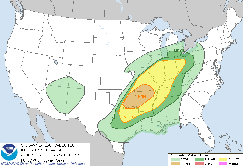
   Day 1 Convective Outlook
   NWS Storm Prediction Center Norman OK
   0106 AM CDT Mon Apr 01 2024

   Valid 011200Z - 021200Z

   ...THERE IS AN ENHANCED RISK OF SEVERE THUNDERSTORMS FROM THE
   SOUTHERN PLAINS TO THE OZARKS AND INTO FAR WESTERN INDIANA....

   ...SUMMARY...
   Severe weather is expected to occur over a broad region from the
   southern Plains, the Ozarks, portions of the Ohio Valley, and into a
   small part of the Mid-Atlantic. Large to very large hail, damaging
   winds, and tornadoes (some strong) are possible. The severe threat
   will peak this afternoon/evening in the southern Plains with the
   greatest threat for the Ohio Valley vicinity being the
   evening/overnight period.

   ...Synopsis...
   A large, positively tilted upper-level trough will shift east from
   the Southwest to the central Plains today. A mid-level shortwave
   trough, currently rounding the base of the large scale trough, will
   advance quickly northeast through the day today within a strong
   mid-level jet. This strong flow will overspread a broad, very moist
   warm sector and lead to severe weather across a large portion of the
   Southern Plains into the Midwest.

   A surface low is present across eastern Colorado this morning with a
   stationary front extending eastward across Kansas and Missouri and
   into the Ohio Valley. This surface low will drift slowly east
   through the day and the front is expected to lift north across
   Missouri as a warm front during the afternoon.

   ...North Texas, central and eastern Oklahoma, southeast Kansas, and
   the Ozarks...
   Mid 60s dewpoints are expected across much of the warm sector east
   of the dryline by mid-day today with temperatures warming into the
   70s to low 80s. Moderate to strong instability is expected to
   develop by the time ascent associated with the approaching trough
   overspreads the dryline. Once this occurs, expect rapid storm
   development along the dryline from southern Kansas to north Texas.
   Very strong shear, and mostly straight hodographs will support
   splitting supercells initially capable of large to potentially giant
   hail across a broad region from southwest Missouri to north Texas.
   Storm evolution off the dryline is still somewhat uncertain. Some
   guidance depicts more discrete development off the dryline and the
   potential for multiple rounds of supercells, while other CAM
   guidance waits until closer to 00Z to convect and leads to upscale
   growth and significant storm interaction within the first few hours.
   This evolution will have a significant impact on the longevity of
   the giant hail threat, but even with a messy storm mode, very large
   hail will remain a threat.

   Low-level shear is expected to be very weak for much of the day,
   which will limit the tornado threat. However, by the evening, the
   low-level jet is expected to strengthen with the ejecting wave and
   low-level shear will improve. The most favorable hodographs are
   expected across northeast Oklahoma into southeast Kansas and
   southwest/central Missouri in a region where mature supercells will
   likely be ongoing. Therefore, a more favorable period for tornadoes
   and potentially strong tornadoes may exist from 23-03Z as the
   low-level shear improves.

   ...Eastern Missouri into southern Illinois...
   At least isolated supercells are expected to develop along the warm
   front from northern Missouri into central Illinois this afternoon
   and evening. Strong instability and very strong shear will support
   large to very large hail. In addition, storm motion is expected to
   be parallel to the surface front. Therefore, any supercells which
   can latch onto the warm front will have a higher tornado threat.
   However, more isolated storm coverage and uncertainty regarding
   storm evolution preclude higher tornado probabilities in this
   region.

   Later in the evening and into the overnight hours, storms from the
   west will move into the region with a threat for large hail, a few
   tornadoes, and severe wind gusts.

   ...Ohio River Vicinity...
   Supercells from Illinois may continue east along the warm front into
   the evening across southern Indiana and potentially southern Ohio.
   Additional storms may also develop along this frontal zone with a
   primary threat of large hail. Weaker instability/shear should limit
   the overall threat from these storms compared to farther west.
   However, moderate instability and strong shear will support a threat
   for large hail, damaging wind gusts, and perhaps a tornado.

   Overnight, a cluster of storms is expected to approach from the
   west. The overnight environment will continue to support a severe
   threat with 1500 J/kg MLCAPE and effective shear in excess of 50
   knots. There is still considerable uncertainty how this cluster will
   evolve. A cluster of supercells would pose a threat for all severe
   weather hazards, while a more organized MCS may support a greater
   severe wind and QLCS tornado threat.

   ...Central Texas...
   Strong instability is expected to develop ahead of a dryline across
   central Texas this afternoon. Confluence along the dryline and weak
   height falls should provide ample support for isolated to scattered
   storm development. Any storms which develop will be capable of very
   large to giant hail, given very strong instability and shear an
   expected supercellular storm mode.
A Moderate Risk was just placed in central/eastern Oklahoma!
Is this mid-day light rain/cloud gonna clear in these areas? Both here and there looks like we're socked in, and this has been occurring since I moved here. Stuff is thinning but I haven't seen the sun shining all day.
-
1
-
-
55, moderate rain and t'storm! There's gonna be a lot of them over the next couple days.

-
 2
2
-
-
14 minutes ago, Clinton said:
The SPC shifted the severe threat a little to the SE in my area tomorrow however Reed Timmer seems to think that eastern Kansas and western MO are right in the thick of things. The best news is that 1 to 3 inches of rain seems likely for my area

Short-range models are showing a number of supercells capable of all hazards developing from the nose of the low-level jet and warm frontal zone near KC into northern MO and off the dry line in central/eastern Oklahoma. The models are trending a bit more significant with this severe weather event.


The severe threat shifts east on Tuesday with another enhanced risk.

2024, year of the upgrades!! Even the outlooks today/tomorrow are somewhat expanded.
-
1
-
-
More severe wx around April Fool's! Just like last year.

I feel like this Spring is bringing more frequent chances of it.
-
2
-
-
1 hour ago, Sunriver Snow Zone said:
If you're going to be all the way in NM, and the forecast is clear, why not make it the extra several hundred miles to see the eclipse?
Who really knows how visible it will be, we're setting up a potentially more active severe wx season this year in some areas.
-
 1
1
-
-
Been having on and off non-sticking snow showers in Ashland this afternoon. From 2-6pm. I think its thinning out, as well as an overall decrease in wind gusts.
36 now, with a high of 41 for the day. Felt a lot like January out here.
-
3
-
-
9 minutes ago, Phil said:
Yep dawn chorus has started. I swear those f**kers wake up before 6AM just to worsen my insomnia.
And the trees behind the house have started to leaf out already. The ones in the picture are all oak and sycamore, which don’t usually leaf out until late April (tho will probably be a few weeks earlier this year).
So far I'm cool with all the local birds. Our cardinals are not obnoxiously noisy.. but there is one bird I'm sure the whole US has, used to bug me at 6am on the west coast and it does here too certain warmer months.
Thankfully I tend to wake up before sunrise but as the nights get shorter its hard to maintain that.
-
18 minutes ago, snow_wizard said:
It does have snow. The view in Tim's pic is misleading. Tim has explained why that mountains looks that way before.
Greta was up there recently with a flamethrower

-
 1
1
-
1
-
-
8 minutes ago, snow_wizard said:
Wield?
A lot of that is because the mountain is steep and isolated. The backside has a lot of snow, and even that face has it under the trees. Also....this just hasn't been a good year for snow in this general area.
Washington Cascades did decently during the first two Ninas that skunked Oregon with dry winters. Must've been due for them to see that.
-
40 minutes ago, MossMan said:
Looks like the perfect time to move to Arkansas!
Find a really cheap home, 'cause it will end up with smashed windows this year..

-
 1
1
-
-
Nice storm early this morning, I started seeing flashing to my north before going to bed, had to get some sleep though.
The squall hit me around 2am, lightning every 10-15 seconds, and a little outflow wind at the beginning of it. Other than 1 or 2 power bumps, we kept our electricity over here.
I heard a few areas had tornadoes but compared to the late February outbreak, I think this was mostly large hail in areas. But there sure were a good number of individually tornado warned cells with these last night.

-
3
-
1
-
-
2 hours ago, Sunriver Snow Zone said:
New Mexico is really nice if you get rid of the big towns, the mountains there are amazing, but putting it above Wyoming in this list is insane.
I bet NM has more run down areas too. I stayed at Grants once and thought that made Klamath Falls look like a nice place in comparison.
-
1
-
 1
1
-
-
6 minutes ago, RaleighHillsRunner said:
I think you’re referring to box elder beetles? Last couple summers we’ve had them pretty bad, although we lost one of our maples in the ice storm so hopefully a few less this year. If you have box elder Maples near the house it’s pretty hard to avoid, but you can have pros come out and do treatments to limit them around outdoor living spaces. We don’t get many inside thankfully.
If they're brown, stinkbug is the correct name (but they don't usually "stink" lol)
Boxelder bugs look sort of like fireflies.
-
1
-
-
2 hours ago, Front Ranger said:
Yeah, this is one of those situations where the airport doesn't represent the metro area at all.
I'm up to 9".
I'm starting to hate airport wx stations.. for nearly the last hour I've heard thunder, none at mine. In fact, I think the station is closer to the storm than I am.

-
1
-
 1
1
-
-
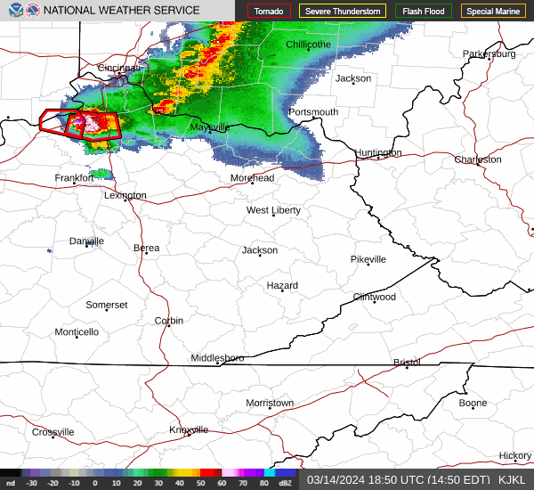
Looks like there's some HP supercell south of Cincinnati? No confirmation yet of it dropping a tornado, but its got some kind of nasty hail core.
-
1
-
-
1 minute ago, ShawniganLake said:
I feel like I’d probably wake up if a tornado hit my house.
Most likely I would get startled awake from booms of thunder before a tornado strikes. But not everyone is a light sleeper like I am.
-
1
-
-
18 minutes ago, Sunriver Snow Zone said:
?!?!?!??!?
They're on permanent standard time, not DST.
I think there's a part of AZ that still observes DST, but you could say the most populated areas don't.
We took I-40 East from Flagstaff a few years ago and remember there being a clock change a couple times in one day. Confusing.. and I really don't think this should be a state to state decision. Just make it national.
-
9 minutes ago, Phil said:
Might hit 80°F again today.

I'll be flirting with my first 80 of the year, forecast to be 79 though. Sometimes I'm 1-2 warmer than they say.
-
2
-
 1
1
-
-
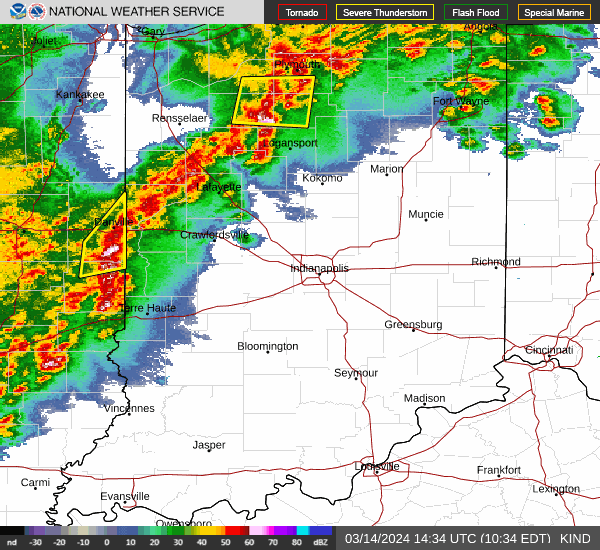
Indiana is gonna get nailed.
-
1
-
-
Some of the Slight and Marginal areas were extended further east.
-
1
-
-
4 hours ago, tStacsh said:
Warm to cold to warm to cold. Hate this time of year. 69 degrees here today full sun. Feels much warmer than the 70 yesterday due to much less wind.
The evening cooldowns are also un-March-like.. 3 hours after the high occurred and its almost the same temperature outside..
Bring on tomorrow's storms!!
-
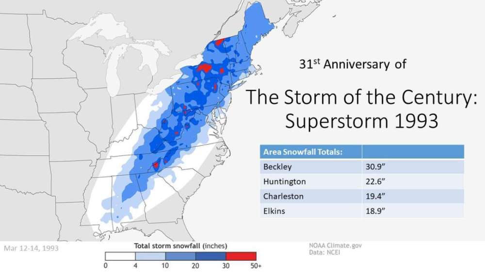
I was just a few months old when this happened. That same winter also slammed the west coast with good snows in Dec '92 through January '93.
There reportedly was over 20" in Ashland with this blizzard.
-
7
-
-
13 minutes ago, Phil said:
Continent-wide torching. You guys were the only cool spot.
I don’t think it’s a guarantee that will be the case this summer. But I hope I’m wrong.
I remember looking up summer 2015 for this area and was surprised at the lack of big heat. Whereas the PNW was in hell that year.
Huntington WV ran cool departures Jul/Aug 2015. How much of the US torched that year?
-
1
-
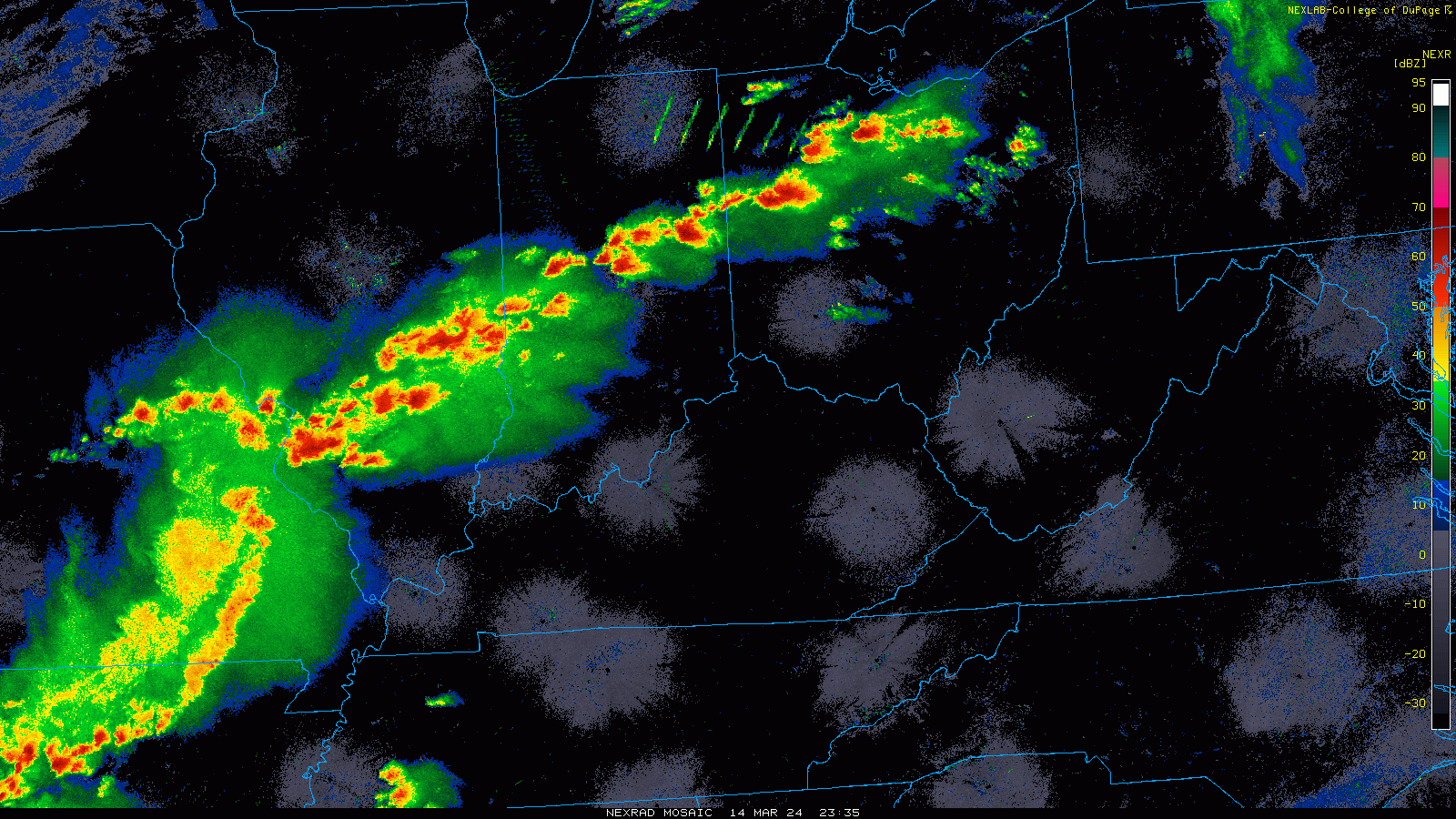

March 31st - April 2nd Potent Plains Storm
in East of the Rockies
Posted
At first I thought the Tuesday evening storms were supposed to weaken coming off tonight's activity. That Moderate in Ohio concerns late Tuesday storms.. so looking at 2 decent outbreaks of supercells potentially.