wxmet
-
Posts
1522 -
Joined
-
Last visited
Everything posted by wxmet
-
The ECMWF is slower with the shortwave dropping down the B.C. which allows the Pacific systems to come further north as a result.
-
Good thing the GFS is lost. This suppression is a bit too much. The only saving grace this run was the Arctic front and c-zones.
-
TPV prevents the system from coming north.
-
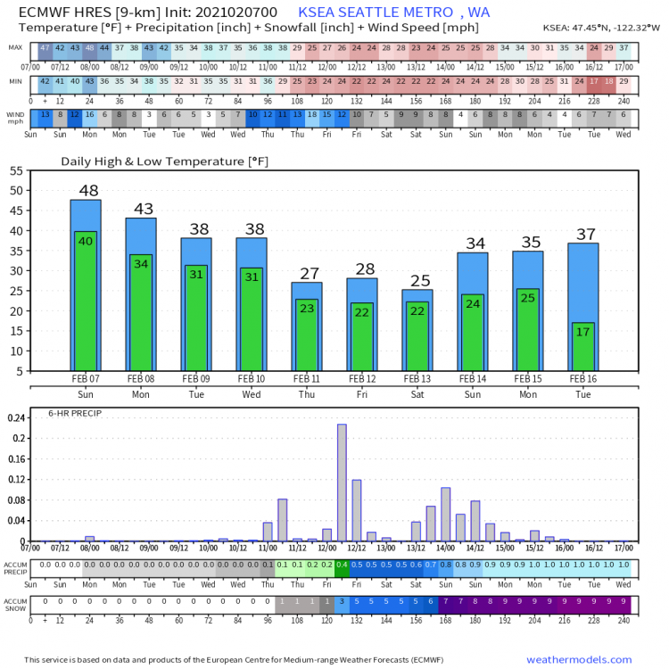
Two inches total into Seattle by Wednesday
-
-
Past few runs of the GFS and NAM have shown the C-zone developing early Monday
-
Sorry for posting the wrong RGEM run. It's late. Here's the right one:
-
ICON 06z
-
NAM wants a more aggressive Arctic front with better off-shore connection like the RGEM
-
Quite a few big hitters among the EPS ensembles
-
30/21 on Thursday here with snow forecast for Saturday and Sunday.
-
This forum is now in storm mode
-

-
The medium range is the ECMWF's deadly range. It's more likely the GFS, CMC et al will come around its solution than the other way around.
-
So either things get suppressed to the south or we get a historic snowstorm. Lots to work out in the coming week.
-
With a meridional jet orientation and divergence within the jet left exit region there is room for the low to track north and precip to extend well into Washington.
-
-
That low will have room to track north as the flow is basically southwest to northeast however cold air is in place thanks to the TPV.
-
More of Oregon will be able to cash in as another low approaches this time with more cold air at 150hr.
-
Euro is a little too close for comfort at this range. A lot of this is going to come down to the timing of the shortwave to the north as to how far the low will be able to get.
-
-
This is different. The shortwave is still digging south due to the TPV circulation.
-
-
What do you mean? This is great lol
-
Friday system is further north on this run. Would be interesting if we could get a partial or complete phase with the TPV shortwave dropping down.