Tom
-
Posts
27200 -
Joined
-
Last visited
-
Days Won
413
Everything posted by Tom
-

January 2024 Observations and Discussion
Tom replied to Minny_Weather's topic in East of the Rockies
I wonder what ppl are thinking in Saskatchewan or Winnipeg? Man, after all the previous winters they've seen this has to be quite a change for them. It's like extended Fall or Spring...nasso much a real Canadian Winter.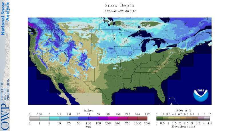
-
January 2024 Observations and Discussion
Tom replied to Minny_Weather's topic in East of the Rockies
The CO Rockies are going to get pummeled to open up FEB...President's day may be your ticket of choice if your still up for a long trip but I gotta tell ya, the blocking, storm track...both favor a bountiful delight of snow. I'm thinking about going there myself mid/late FEB if I can find some friends to tag along. -
January 2024 Observations and Discussion
Tom replied to Minny_Weather's topic in East of the Rockies
The Omega Block which has been a signature pattern since the beginning of the LRC is showing it's mighty self as we open up FEB. The question will be, how big of an influence can this driving force play for the storm train that will pound the West/SW and eventually for our Sub??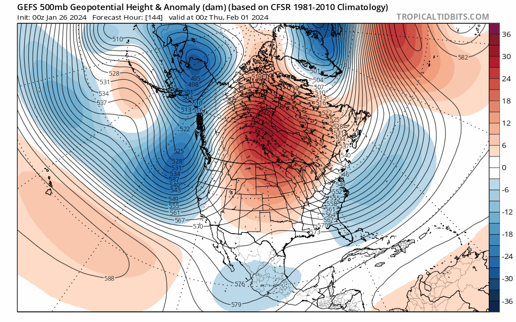
-
January 2024 Observations and Discussion
Tom replied to Minny_Weather's topic in East of the Rockies
Boy, I did expect to see the growing trends of HP across S Canada but NOT to this extent....what the models are showing is something you would normally see in early Spring like in MAR or APR. Crazy Blocking pattern. That Hudson Bay Block is throwing a massive curve ball as to what happens with the Storm entering the 4 corners to open up FEB. Buckle up...this will be interesting to see the model trends over the next week. I'm expecting FEET of that lovely Powder to fall up in Flagstaff and White Mountains. How about you guys farther East? Let's see if Mother Nature finds a way to cool things off and make it Snow....LFG!! -
January 2024 Observations and Discussion
Tom replied to Minny_Weather's topic in East of the Rockies
That's quite fascinating and thanks for sharing this info about the grass still being green after the last arctic blast. The snow definitely had a blanket effect on the soils. Now, if this was up north where they depend on trails and ice, this would be a bad scenario as they usually want to see arctic air without any snow to freeze up the ground. Hopefully you can rebuild that nice snow pack by the 2nd week of FEB into MAR. Yes, I posted video's of a trip I took back on Jan 7th up into the White Mountains in Pinetop/Lakeside, AZ. It was a wonderful experience driving through Blitz conditions and powder blowing sideways. -
The JMA weeklies are "Gun Hoe"...Look out Below...Winter coming back Big time...right around the 8th is when those out in the western Sub see it first, quite possibly before then...depending on how the system that tracks through the 4 corners around Ground Hogs Day evolves. Week 3-4... Temp/Precip...that looks brutal cold for a LR temp anomaly off this model... Precip...that ribbon of AN on the leeward side of the Rockies is very very intriguing as it cold imply a LOT of CO Low's in this pattern or, for better or worse, TX Panhandle cutters??? Let it SNOW, Let it SNOW, Let it SNOW... @gimmesnow @Madtown This is when you guys should see a more favorable northerly flow off Lake Superior...
-
January 2024 Observations and Discussion
Tom replied to Minny_Weather's topic in East of the Rockies
Hmmmm, maybe the GFS was not so much "Out to Lunch" for the later part of the month. The EURO appears to be siding with GFS on a pretty big Flip near the GL's/OHV region as an amplified trough crashes down into the East. GFS/EURO/UKIE suggesting a clipper for our GL's peeps to close out the month of JAN. -
January 2024 Observations and Discussion
Tom replied to Minny_Weather's topic in East of the Rockies
It took till mid afternoon for the sunshine to finally poke through the clouds but once it did I felt an immediate positive vibe. One thing about living in Fountain Hills, your tucked away from the PHX valley in your own little valley with Mountain View’s. The main road that brings you into FH from Scottsdale rides up a nice hill and you get a great vantage point of the PHX valley. I took this vid just as the sun came out. You can see how low the cloud deck was at the time. filtered-F974DD9B-09F9-4CE1-BC0E-EF2917DB2AB3.mp4 -
January 2024 Observations and Discussion
Tom replied to Minny_Weather's topic in East of the Rockies
This week's of weather is not turning out the way I had envisioned it to be as I was hoping to see more colder HP's straddling the northern tier while the STJ fired up this week. Just imagine the possibilities if there was just enough cold air around for all these "cutters"...I believe there will be 4 of them this whole week! Sadly, no snow but lots of liquid that'll help put a big dent into the drought areas. -
January 2024 Observations and Discussion
Tom replied to Minny_Weather's topic in East of the Rockies
Happy Thursday! Out here in the Desert Southwest, I have been sharing in the foggy/dreary days like many of you out East from the series of storms that have tracked literally directly overhead. My father flew back last night from a 2-week adventure in the Chicago area, as well as, Holland, MI for my nephew's hockey tournament during the Arctic Blast on MLK weekend! Back on Jan 7th when I went up to the mountains storm tracking I jokingly told him this is a preparation for what your going to deal with in Chicago. Well, I will confidently say, this is probably his last time he will be going back there during the Winter! At his age (76), he's had enough of the cold and snow...especially the -10's F stuff that he had to deal with in Volo, IL. Aside from that, how about some sunshine to lighten up the day?? That's the plan with Mother Nature out here later today...and...the extended...upper 70's?? Sign me up. -
January 2024 Observations and Discussion
Tom replied to Minny_Weather's topic in East of the Rockies
I think that is in a general ENSO base state and not during an El Nino...Bastardi posted something regarding this on his Blog. Maybe someone else can chime in and provide feedback. -
January 2024 Observations and Discussion
Tom replied to Minny_Weather's topic in East of the Rockies
So, I hear Phase 7 MJO in El Nino Feb's are golden...if this is true, then there is model consensus we will enter a favorable pattern to open up FEB...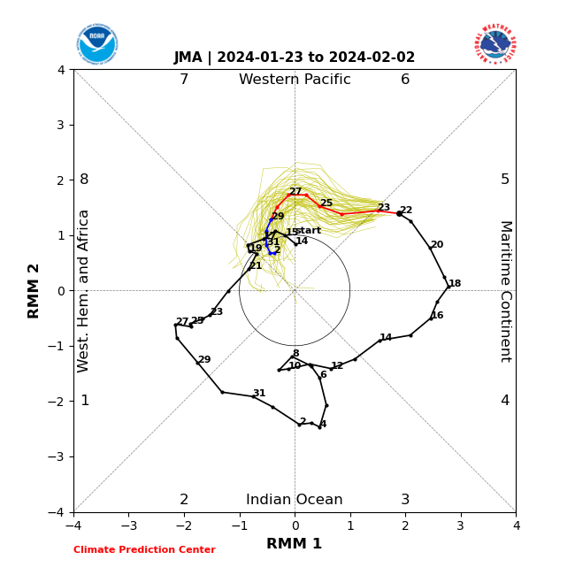
-
January 2024 Observations and Discussion
Tom replied to Minny_Weather's topic in East of the Rockies
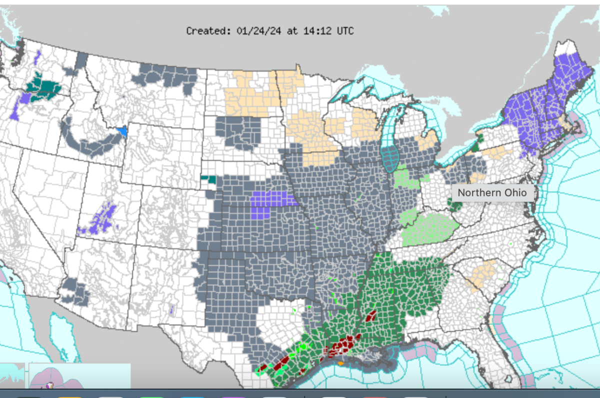
It's amazing how much of the central CONUS is under a Dense Fog Advisory...is Nature saying something for Mid Feb and beyond??? If you look closely, it sorta resmebles where the LRC storm track has been and also where the snow/Ice has fallen that last 4 weeks.
-
January 2024 Observations and Discussion
Tom replied to Minny_Weather's topic in East of the Rockies
Looking forward to seeing a wild storm train down here in the PHX valley after a nice warm spell this weekend into next week. Yesterday, my area in Fountain Hills received well over an 1" (1.35") of wonderful rain that soaked into the soils. PHX officially received a 0.41" RN which is a daily record. It's been a cloudy, dreary last few days here in the Valley of NO Sun! But wait, that will turnaround later today through the entire weekend. -
January 2024 Observations and Discussion
Tom replied to Minny_Weather's topic in East of the Rockies
Big Snows heading into the southern Mountains of Arizona...I don't remember seeing a forecast for this much snow for Mt. Lemmon!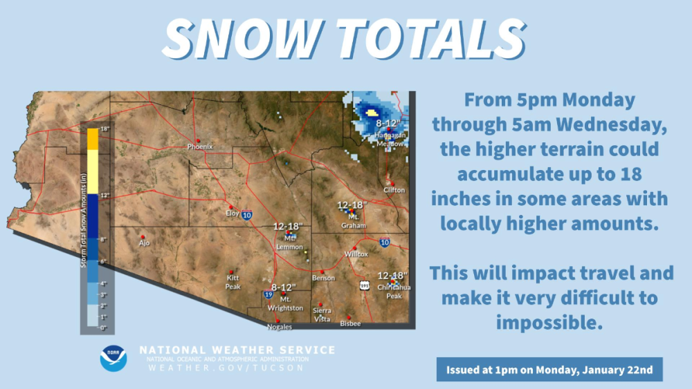
-
January 2024 Observations and Discussion
Tom replied to Minny_Weather's topic in East of the Rockies
The part of living in the MW during the Winter time that was most depressing to me is what you guys are experiencing this week and next. To see such a deep & beautiful snowpack slowly fade away is something that was very emotional to me that ONLY a snowlover can understand! Ughh, I feel ya guys....after such a nice long cold snap you would want to see it going, but no, not this year. I guess we'll just have to see Mother Nature restore the glory of a deep snow pack in FEB...but then your having to deal with higher sun angles, longer days, etc... you know what I mean. -
January 2024 Observations and Discussion
Tom replied to Minny_Weather's topic in East of the Rockies
What week in FEB would you consider going? I'm also debating on either Park City or Aspen/Vail sometime in FEB... -
January 2024 Observations and Discussion
Tom replied to Minny_Weather's topic in East of the Rockies
Yup, I feel ya, but I'm more optimistic than not for your area and points west to fill up with snow before the real deal Winter pattern kicks in post Feb 7th/8th... -
Update on the SSW event that began on JAN 18th according to the JMA center... https://ds.data.jma.go.jp/tcc/tcc/products/clisys/STRAT/
-
Super Bowl Blitz??? Come on baby, I smell something Big during this period...its Game on post Feb 5th for your region as the Pattern Reloads in a Bigly Fashion...
-
January 2024 Observations and Discussion
Tom replied to Minny_Weather's topic in East of the Rockies
Will you be able to Top this come mid FEB? If the northern Tier of the U.S.and Southern Canada fills up with more snow as the pattern reloads during this upcoming Thaw, IMHO, this could really set the stage for a long stretch of cold and snowy weather for the Heartland. In a perfect world, the Nanook from the North would like to see some more snow cover up this way.... For WY/MT and the Upper MW, the best signal for this season is dialing up as we open up FEB....mother nature should deliver the GOODS... 0z EPS/GEFS all starting to show a lot of support for a big ticket winter storm to develop over the central CONUS. The Big Question is, how much blocking will there be in southern Canada? How much residual cold will be available? The models are going to be all over the place with this storm system just like they were in late DEC figuring out the Christmas Day Blitz. Once the PAC JET begins to cut underneath all the Blocking up across NW NAMER & Canada around the 7th/8th of FEB, this should rebuild the Glacier and the Arctic Attack will Cometh with Vengeance!
-
January 2024 Observations and Discussion
Tom replied to Minny_Weather's topic in East of the Rockies
As the incoming JAN Thaw rears its ugly head, I wonder how much that wet snow that fell will subdue the snow melt. Anyone that lives farther away from the city of Chicago fair a better chance of holding onto it longer. The NW burbs should be far enough away that temps don't torch into the 40's this week and DP's appear to be held in the low/mid 30's for most of the MW/GL's. I hope to see the snow pack in tact by end of this coming week...what happens the following week is still crap shoot as there could be a solid but brief cold snap for the GL's/OHV. I'm eyeing a big time Ground Hog's day Storm around here in the 4 corners that will eventually head East into a massive Bowling Ball for the opening week of FEB. This pattern looks to resemble the Christmas Day Beast. I expect to see a lot of trends for more blocking across S Canada. -
Hopefully another Super Bowl Blitz or Valentine’s Day blitz?
-
January 2024 Observations and Discussion
Tom replied to Minny_Weather's topic in East of the Rockies
To date, ORD is up to 20.0" of snowfall...let's keep it going... -
January 2024 Observations and Discussion
Tom replied to Minny_Weather's topic in East of the Rockies
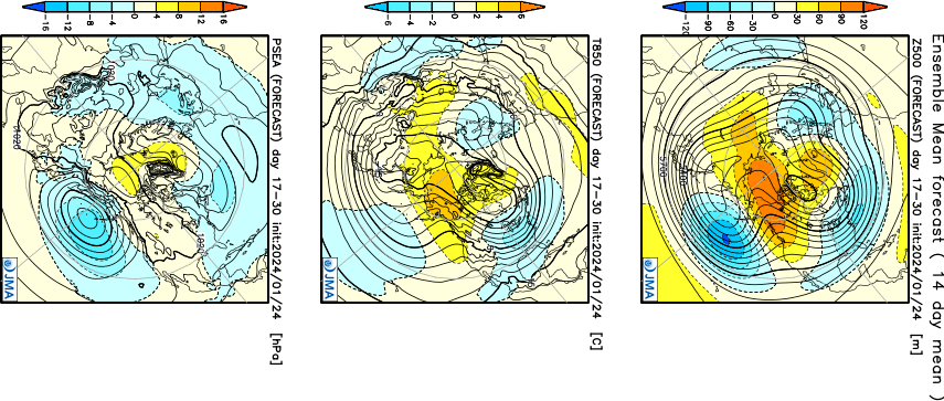
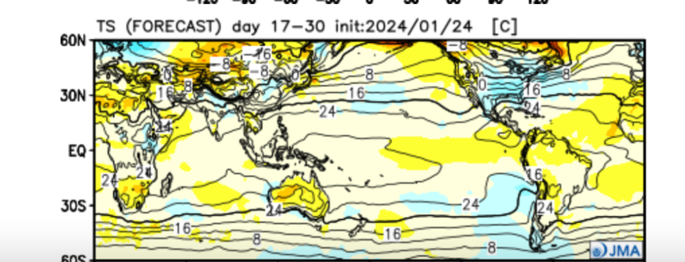
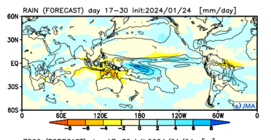
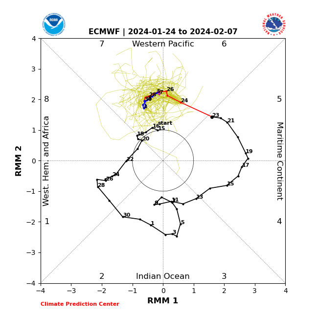
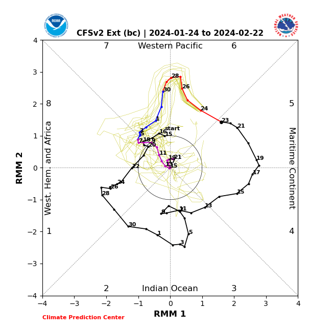
So, here we go with Round 2....both 10mb/30mb Strat warming ongoing... At 30mb, its even stronger than the last warming... Over the past few days, the JMA has been the only model showing the MJO head into the NULL phase rather quickly before months end...this has been quite the battle as every single model had different solutions. Unexpectedly, the GEFS ext just updated their run and low and behold, we have some similarities...now I see why the last 2 GFS Operational runs push the colder air farther south into the Lower 48. Is this a hiccup or something that can manifest into reality?