Tom
-
Posts
27151 -
Joined
-
Last visited
-
Days Won
413
Everything posted by Tom
-
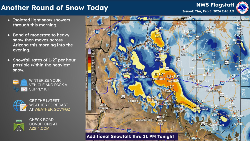
It's been a hellova past couple days around these parts as we have seen a good amount of rain in the valley along with some hail or graupel that was reported at the Waste Management Open yesterday. I'm waiting for more reports to come in but the last one up in Flagstaff shows a 2-day total of 23.1" of Snow! It continues to snow up there and has not stopped since it start on the 6th and probably won't stop till Friday am. The footage up there looks amazing and also near Pinetop where they got 15" of new snow. Today, another potent little storm will dump close to another Foot up in Flagstaff and the Rim Country. Hands Down, this has been best stretch of winter for the state of Arizona. The series of cold storms has really helped the snow pack after a slow start to the season. The Colorado basin is at 120% of normal and that # is likely to increase over the coming month. Just another day in paradise up in Mountain Country...
-
You don't think the weather cycles??? I remember vividly when this storm developed back in the Autumn and had a lot of confidence this would deliver the goods over here and the Intermountain West.
-
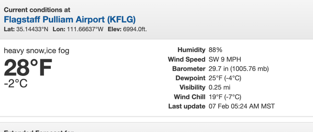
Happy Humpday! Just an incredible amount of snow has fallen across Flagstaff and the Snowbowl Ski Resort. I turned on the local news channel around 4pm last night and they had about 3-4" of wet snow but then it got real heavy as it must have puked snow overnight. FLG reported just after 1:00am local time 16.5" of snow and it is currently snowing Heavily. They expect another 10-16" just today! On the other hand, Snowbowl received a whopping 26" in 24 hours! Incredible.
-
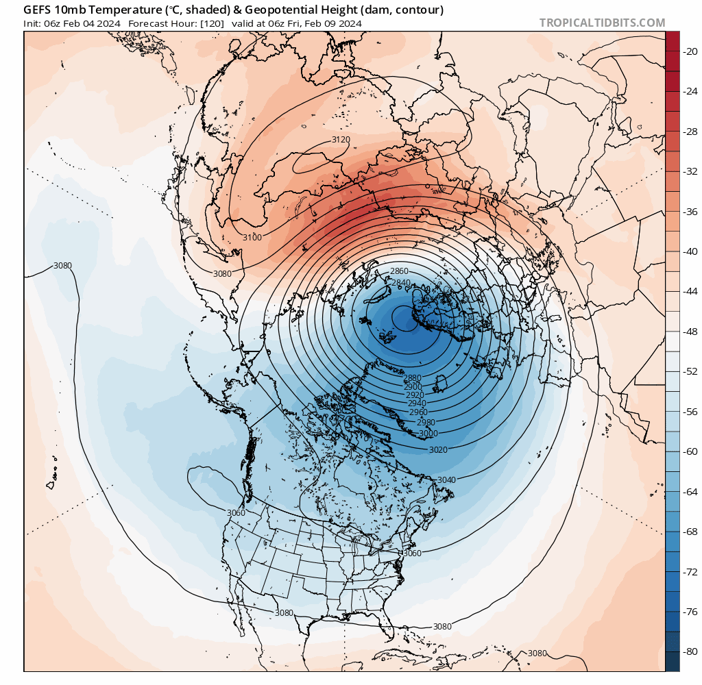
Its not a bad thing that the next storm is cutting NW bc it will lay down the carpet where they have been missed for pretty much the entire snow season...This should aid in the cold once the pattern locks for the remainder of Met Winter. Hopefully @Beltrami Islandcan somehow score on the backend of this system. It's wild to see the consistency from basically all the models in the LR to dislodge of the PV just south of Hudson Bay by mid month. The Greenland Block is going to produce a favorable pattern for Severe Cold. It all depends if there will be a snow cover around but the Lakes will no doubt be on Fire by Valentine's Day.

-
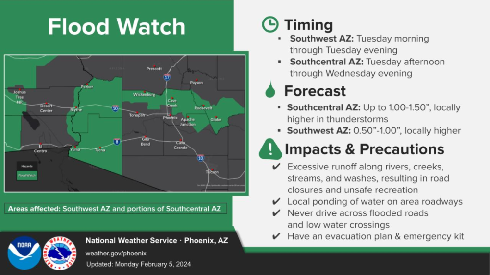
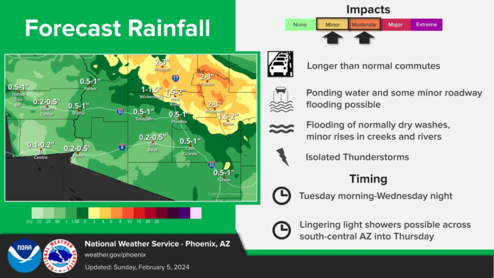
Alright, Alright, Alright....Happy Monday...Big week of Golf for the valley as the Waste Management Open begins this Wed thru the weekend. The weather looks a bit ugly but gets better for the weekend...albeit, cool but as long as the Sun is out it'll feel better. Big time rains coming for MBY 1"+ along the foothills into the mountains. Flood Watch's issued and tremendous RN and SN coming up for Tue-Wed. The Mogollon Rim is expecting 10-16" of Snow and the Flagstaff area should do well also.
-
This is interesting...Final SSW event for the season??? Big reason that this Winter season is going to have some back loaded legs....I remember a warming event like this one in mid FEB that delivered the "Beast from the East." I'm wondering if this sets the stage for a "Marvelous March"...in terms of Big Snows....this has potential for some interesting Winter shenanigans.
-
Buckle up! Still plenty on the table till Spring…It also appears the jet will be wild for down here as well which gives me more opportunities to visit some more places before it gets warm.
-
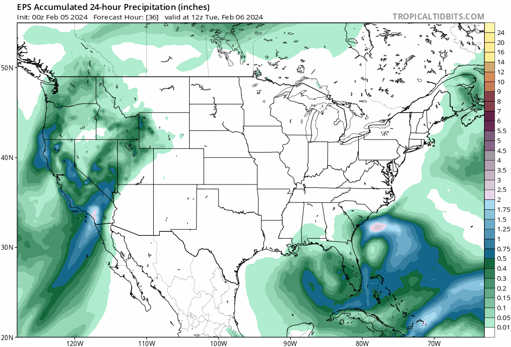
FLG reported a 2-day total of 9.8" of powder the past couple days...I'm waiting for the updated totals for Sunrise Ski resort to my East as they easily scored the most snow. This coming week is going to be the best winter stretch for the mountains of Arizona. I'm fully expecting to see multiple FEET of Snow for the White Mountains and up north near Flagstaff. The Waste Management Open is starting this week and the weather is not going to cooperate this year. Most years its rather nice but nasso much this year as the pattern will be cool and wet, however, it should clear up later in the work week. BIG Snows forecasted by the Euro... Wait, what's this??? Superbowl weekend Snow??? Let's see how this rolls over the coming week...
-
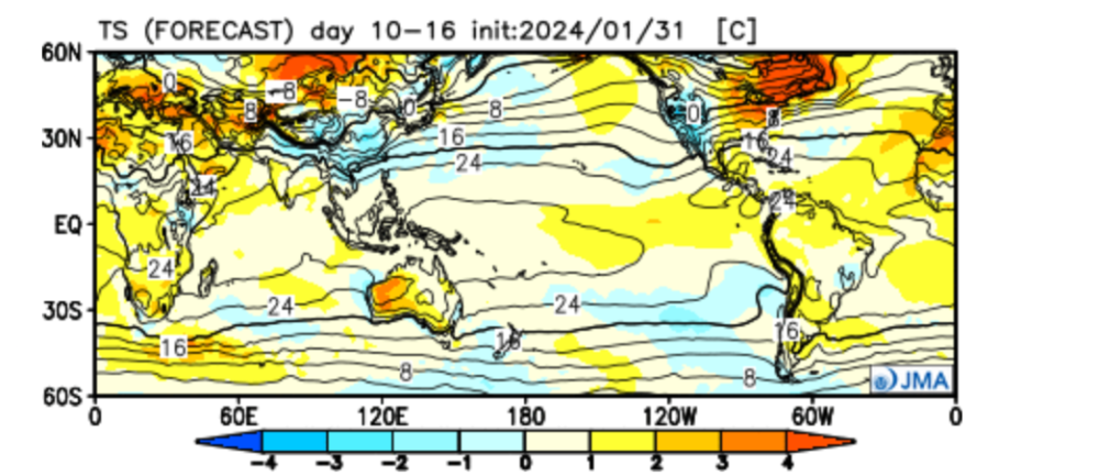
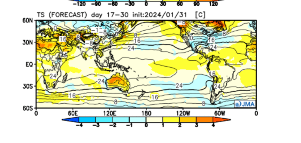
Ya, I fully anticipate a strong finish to winter for the Heartland and into the East Coast. The JMA weeklies from yesterday pretty much suggest this also. Week 2... Temp & Precip... Its running a little warm bc its covering next weekend's blow torch but around the 13th or so I think it gets colder. Week 3-4... Temp & Precip...The GL"s should really fire up in this pattern...


-
Yesterday, it was the 3rd day in a row that PHX hit a high of 81F! It's not often you get temps to max out in the low 80's in the winter...is 81 the lucky number? Last night around 7pm the valley was blessed with quite the rainfall as my area yet again was the bullseye (1.30 of RN). The east valley got hit big time while PHX had about 0.53" of welcomed rain. What a turnaround after such a dry Autumn. The blocking and STJ really fired up around here and hopefully it can continue late into the Spring.
-
That brown ribbon right through the heart of MSP is a dagger to any snow fan. I guess it had to come sooner rather than later bc they’ve had the hot hand over the past few years. Overall, MN needs the precip as we turn the corner towards Spring.
-
The painful and depressing times I do not miss while I lived in Chi…I’d much more rather rent a cabin in the mountains for a month and see snow on snow on more snow and enjoy the outdoors. Give me one good month of winter where snow sticks around and the snow depth is deep and I’ll call it a success!
-
How much snow have you had this season?
-
Knock, Knock...Who's there?? It's me...The CO LOW..."Well, where you heading?" Heading East, then South...Don't worry, There won't be any snow this time...you can thank El Nino! What a wasted opportunity....I really was hoping this storm would have been a gnarly one for the Plains/MW...the way this winter and past winters have been of late, this will prob cycle through in Mid March...aka, "March Madness"...back loaded winter for the Southern tier?
-
Law of averages...had to happen one year or another...You'd think that a Strong Nino would do the trick for a sub par winter...
-

January 2024 Observations and Discussion
Tom replied to Minny_Weather's topic in East of the Rockies
3rd day in a row PHX hit a delightful 81F! High clouds moving in out ahead of the big storm. Should be raining heavily here as the line of heavy rain moves in around 8pm. Big snows for the ski resorts. -
January 2024 Observations and Discussion
Tom replied to Minny_Weather's topic in East of the Rockies
It was a "Terrific Tuesday" as PHX topped out for a high of 81F, just 1F shy of the record (82F)...we have one more day of Spring-like weather and a sunny day ahead today before the storm begins rolling in Thu pm. Looking forward to a "Wonderful Wednesday" and soaking up that Vitamin D! -
Some consistency?? CFSv2 weeklies suggest Phase 8 by the same timeframe...better late than never I guess... Finally, the GEFS ext. also saying all systems Go for a Phase 8 MJO! Let's see how this all plays out...I'm really eye balling the Super Bowl weekend wx pattern. Maybe we'll be tracking a couple systems during that week and building up the excitement for the Big Football weekend and some Snowstorms!
-
It's too bad the CO LOW is going to be a wasted storm but it does appear the models are starting to show some arctic air to come back into the pattern around the 8th or so for the Upper MW. The Euro Weeklies for the 2nd run in a row are showing an amplified Phase 8 by the 14th/15th....end of MET Winter Rally???
-
January 2024 Observations and Discussion
Tom replied to Minny_Weather's topic in East of the Rockies
PHX hit a high of 81F yesterday! A couple degrees shy of the record but today we may get close to tying a record of 82F as we expect to see a carbon copy. Light winds, plenty of sun...you can find me by the Pool today! Certainly getting summer vibes out here as the days are getting a little longer week by week. It's been a chilly January for the most part and we are going to cool down quite a bit this weekend. So far, we have had 18 BN Days, 5 normal and 8 AN days...we'll add a couple AN days today and tomorrow. A very active pattern sets up as we flip the calendar into FEB which appears to be a cooler and wetter one. -
January 2024 Observations and Discussion
Tom replied to Minny_Weather's topic in East of the Rockies
That was tough to watch as those 2nd half mistakes really costed them the game! The players had "butterfingers"...unfortunately, when you play a great team like the 49r's, they'll make you pay. I believe they have a great future and I really like their Head Coach. -
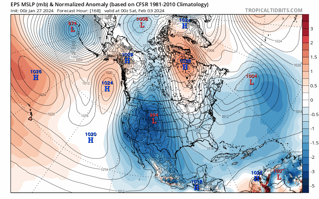
12z GEFS temp trends last 12 runs...this could end up a marginal set up but the power of the storm to generate its own cold air along with stronger Canadian HP could very well trend snowier for the Plains/S MW...this is for the Feb 3rd-5th storm....
-
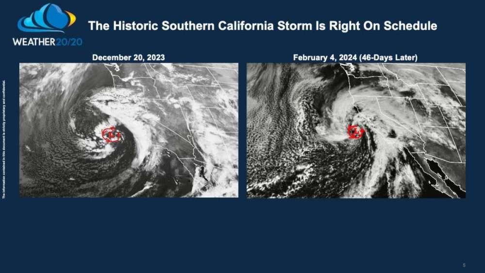
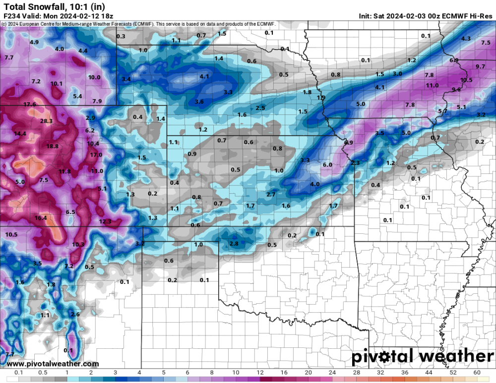
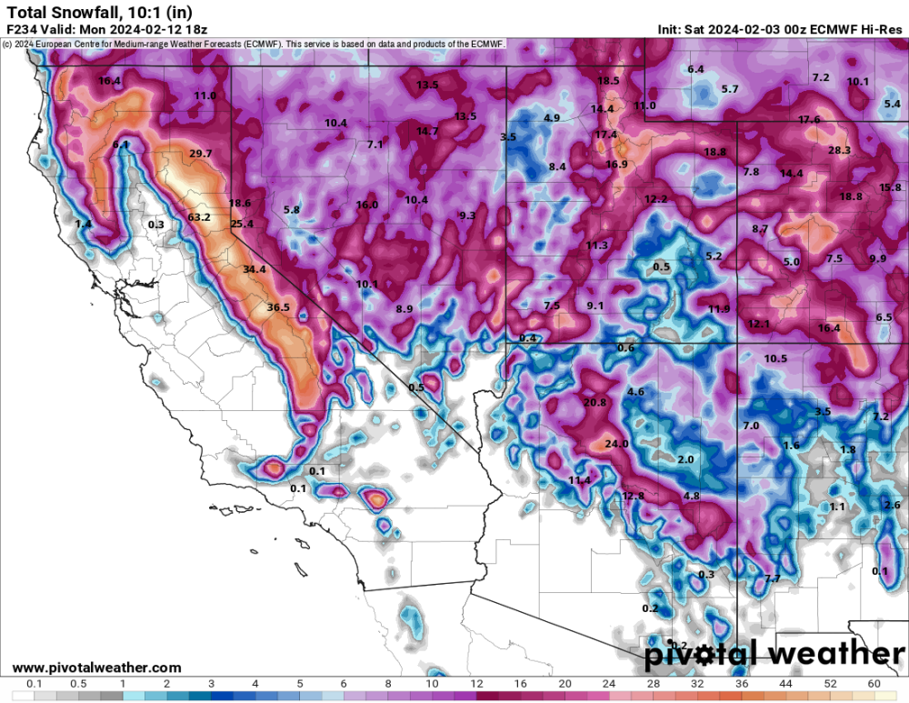
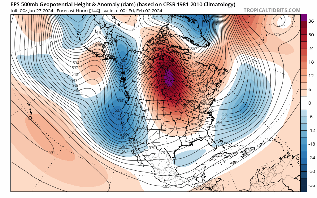
0z EPS... 3 days ago... 4 days ago...there was NO model that saw the amount of Blocking over S Canada...fast forward to today's runs, you see why I'm getting pretty stoke to see a classic CO Low.... BUT wait, there's more...how about we dial up a Superbowl Weekend Blitz???? I know that is way out in Lala Land...but the LRC suggests a Big Ticket storm and the ensembles are sniffing it out. IMHO, some peeps on here that were getting hit will continue to get hit but I do see a possibility of the storm tracking setting up a bit more south this time by the 10th-12th. Ya'll ready??
-
I don't know about you but this is just beautiful....Classic set up for a CO Low...Hello Omega Block?? Let's see if the colder trends win out bc this is not like its later in MAR or APR where your begging for cold air. Hope to see the KC peeps and @Clintonin the mix with this one.

-
January 2024 Observations and Discussion
Tom replied to Minny_Weather's topic in East of the Rockies
Fired up a FEB thread as it is Time...