


bud2380
-
Posts
5974 -
Joined
-
Last visited
-
Days Won
11
Everything posted by bud2380
-
21z RAP
-
I'm diving in head first with the GFS. 20" for my backyard or bust! Not that I'll be able to measure it properly. We're going to see incredibly varying snow reports with this storm. With 8-12" on the ground in many places already and 6-15" more coming in spots, and blowing and drifting. Measuring will be incredibly difficult and will lead to wildly varying reports even in the same cities I am sure.
-
You could take the words "one of" out of it for me. Never experienced anything like this in 3 days.
-
Holy cripes this is almost 20" at my house.
-
18z GFS...OMG! I'll never get back out of my house if this verifies. LOL.
-
I would hope for fan safety they cancel. Iowa was once a couple hours before tip all ready to play Indiana in Bloomington when a game got canceled because a ceiling tile fell. It was late in the season and couldn't have come at a worse time too. Iowa ended up cramming the makeup game in and had to play 3 straight road games in one week and lost them all. So they shouldn't feel bad about canceling on Nebraska tomorrow.
-
My point forecast still says 5-9" despite the blizzard warning saying 7-14" WTG NWS.
-
I know I have season tickets. I'm only 20 miles away, but don't think I'll venture out in it regardless. There won't be any fans there.
-
-
Blizzard Warning URGENT - WINTER WEATHER MESSAGE National Weather Service Quad Cities IA IL 303 PM CST Thu Jan 11 2024 IAZ040-051>053-063>065-067-068-076>078-087>089-098-ILZ015-016- 024>026-120545- /O.NEW.KDVN.BZ.W.0001.240112T2300Z-240113T1800Z/ /O.NEW.KDVN.WC.A.0001.240114T0000Z-240116T1800Z/ /O.EXT.KDVN.WS.W.0002.240112T0300Z-240112T2300Z/ Buchanan-Benton-Linn-Jones-Iowa-Johnson-Cedar-Muscatine-Scott- Keokuk-Washington-Louisa-Jefferson-Henry IA-Des Moines-Van Buren- Rock Island-Henry IL-Mercer-Henderson-Warren- Including the cities of Independence, Vinton, Cedar Rapids, Anamosa, Marengo, Iowa City, Tipton, Muscatine, Davenport, Bettendorf, Sigourney, Washington, Wapello, Fairfield, Mount Pleasant, Burlington, Keosauqua, Moline, Rock Island, Geneseo, Aledo, Oquawka, and Monmouth 303 PM CST Thu Jan 11 2024 ...WINTER STORM WARNING NOW IN EFFECT FROM 9 PM THIS EVENING TO 5 PM CST FRIDAY... ...BLIZZARD WARNING IN EFFECT FROM 5 PM FRIDAY TO NOON CST SATURDAY... ...WIND CHILL WATCH IN EFFECT FROM SATURDAY EVENING THROUGH TUESDAY MORNING... * WHAT...For the Winter Storm Warning, heavy snow expected with a period of mixed precipitation along and south of a line from Sterling, Illinois to Fairfield, Iowa. Total snow accumulations of 7 to 14 inches, highest north of Highway 30, and ice accumulations of a light glaze. Northeast winds gusting as high as 40 mph. For the Blizzard Warning, blizzard conditions expected. Northwest winds gusting as high as 50 mph. For the Wind Chill Watch, dangerously cold wind chills possible. Wind chills as low as 40 below zero. * WHERE...Portions of northwest and west central Illinois and east central, northeast and southeast Iowa. * WHEN...For the Winter Storm Warning, from 9 PM this evening to 5 PM CST Friday. For the Blizzard Warning, from 5 PM Friday to noon CST Saturday. For the Wind Chill Watch, from Saturday evening through Tuesday morning.
-
Blizzard Warning just issued here!
-
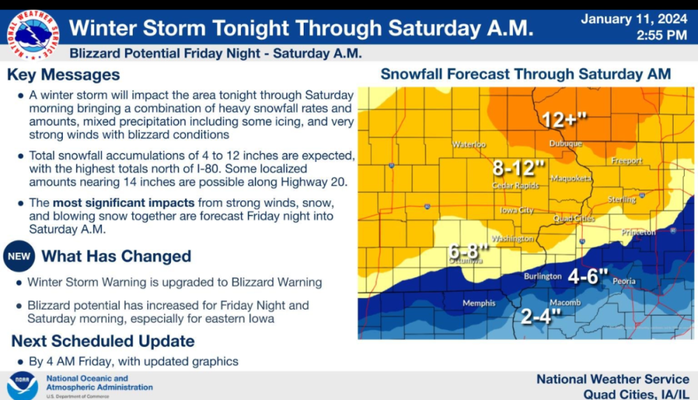
DVN new graphic shows 8-12" for much of the area with 12"+ in far NE Iowa.
-
NAM came south quite a bit in eastern Iowa anyways. Iowa City getting destroyed this run.
-
-
No, my wife's co-worker told her that this kid has never been wrong. I'm sure he does a fine job, my opinion is that he's a little too aggressive with his snow fields on this one, gets too far up into MN with accumulating snow and the heaviest bands.
-
12z HRRR at noon 18z HRRR at noon
-
through 10am tomorrow the HRRR has 3" more in Iowa City vs. the 12z run.
-
Meanwhile, 18z HRRR is coming in further south vs. the 12z run.
-
My wife just sent me the same thing that someone at work sent her, and that this 17 year old kid who runs the site "has never been wrong" LOLOL.
-
Euro with about 2" more in CR than the 00z run, but still is about the lowest end of guidance on snowfall totals. Just doesn't have the QPF here that other models are showing.
-
Euro really increasing totals in Nebraska vs. 00z.
-
GFS and Euro are worlds apart on QPF. GFS at 3am is way stronger vs. the Euro.
-
The RAP actually brings rain into far SE Iowa as 850s rise above 0.
-
LaCrosse AFD mentioned the possibility of 2+"/hour rates with this lead WAA band. As main wave in question rounds base of western trough and ejects northeast towards the Great Lakes on Friday, lots of dynamics in play that will lead to impressive cyclogenesis. Based on 11.03z RAP surface low will deepen from 996 mb near Kansas City tonight to 966 mb over Lake Michigan east of Milwaukee by Friday evening. Hints of coupled jet streaks across the region as well with divergence aloft and broad, strong lift as wave becomes negatively tilted and swings into Great Lakes. To no surprise low level wind field is quite strong ahead of low advecting moisture into the system as it lifts northeast, with hints of strong isentropic lift and mid level frontogenetic banding. In fact, this feature could lead to high snowfall rates /2"+ per hour/ early Friday morning as forcing lifts north.
-
from midnight to 6am the RAP just hammers Eastern Iowa. 9.2" in Iowa City in a 6 hour period.


