

BLI snowman
-
Posts
16285 -
Joined
-
Last visited
-
Days Won
38
Posts posted by BLI snowman
-
-
Snowing here at 350'.
-
 8
8
-
-
11 minutes ago, SilverFallsAndrew said:
This week is a gift.
Could be a slushy inch up your way at some point?
-
2
-
 1
1
-
-
9 minutes ago, lowlandsnow said:
GEM is really good for mountain snow though
Knocking on a whole bunch of wood, but I think we're just about at the point where an embarrassment of snow riches is virtually guaranteed for the mountains.
-
4
-
 1
1
-
-
GFS is great.
GEM is not.
-
1
-
-
21 minutes ago, Cascadia_Wx said:
48 with a low overcast and light rain here.
Think he's down in Eugene now?
-
1
-
-
9 minutes ago, SnowWillarrive said:
I always consider SW WA to be part of PDX. Where do you live again though?
I consider Seattle to be part of greater Canadaland.
Real WA extends up to about the Tumwater Costco, and then the Ritzville Les Schwab on the east side.
-
2
-
1
-
 3
3
-
-
4 minutes ago, TigerWoodsLibido said:
Yeah if the 522dm thickness line crosses us in heavy precip and onshore flow it will upslope here and cause more precip and lower the snow level.
Your current location probably got nailed with the March 21-22, 2012 storm. Eastern side of the valley always does better with onshore flow and anafronts.
-
4
-
-
3 minutes ago, MR.SNOWMIZER said:
It's not what I was trying to say. 1500ft in southern Oregon to 500 feet at Canadian border is more like it.
With regional onshore flow, there's not likely going to be much of a latitude difference. Coos Bay could be just as likely as Bellingham to score accumulating snow.
-
8
-
-
3 hours ago, snow_wizard said:
Really solid cold here.

Any sub-40 high in March is serious bidness.
SEA hasn't had one since 2009.
-
4
-
-
1 hour ago, Front Ranger said:
Yeah, I mean most locations right on the water at sea level are not great for snow in the Puget Sound region, obviously.
But Seattle tends to do a little better than some areas further south like Fife and Puyallup, mainly due to occasional CZs, Arctic fronts, and Fraser Valley seepage that stalls.
Outside of Dec 1990 and March 2002, see: Dec 1996, Nov 1985, Dec 1984, Nov 2006, Nov 2010, Jan 2012, Jan 2020, Feb 2021.
Shadowing isn't a huge issue most of the time, because that's greatest with straight westerly or SW flow, which isn't usually ideal for snow anyway.
Shadowing absolutely impacts Seattle's snowfall compared to the wetter places further south. You just have to look at Olympia's averages to see that. The South Sound generally does better from that alone, and obviously Snohomish County does way better from the PSCZ which often picks up between Lynnwood and Shoreline. Seattle is in something of a snow-no-man's-land a lot of the time.
-
18 minutes ago, snow_wizard said:
Seattle does get the occasional C-Zone though. Also downtown had a big snow in Dec 1996 when it was only ZR south of there. Probably also way outdid Fife in Jan 2012.
That storm was actually deeper the further south you went. Amounts peaked around Lewis County where they had 17-18" in Centralia. But the South Sound did quite well up through Tacoma, while I think Downtown Seattle had about 4" with the main event and then a couple inches with the initial c-zone.
It's rare for Seattle to be at the epicenter of any event, outside of the odd c-zone. Geography pretty well sees to it with the shadowing and quick moderating power of the Sound. That's what made December 1990 so special, because they got clobbered in downtown while ironically SEA only got a fraction. March 2002 was another one.
-
3
-
 1
1
-
-
1 hour ago, Front Ranger said:
Seattle is easily better than Fife or Puyallup. Especially north Seattle, which at least can get in on CZ action sometimes.
Downtown Seattle is probably about equal to Fife, being that they are both on the water. Puyallup seems like they get a little less shadowing at least?
-
1
-
-
1 hour ago, Gummy said:
787 days now since Seattle had a decent event with greater than 3" of snowfall. Late time was that amazing storm that hit the day after Christmas in 2021. Hopefully the winter of 24-25 can end the streak. I would hate to reach 1000 days, that would be very depressing.

Been three of them here since then. 4/11/2022, 2/22/2023 , and 1/13/2024.
Snowfall wise, Seattle is probably the worst inland place in Western WA.
-
2
-
 1
1
-
-
7 minutes ago, SilverFallsAndrew said:
I went to Milton-Freewater last summer, I've been through Walla Walla, but have never approached from the south. Really a beautiful area, going into MF you think you've traveled back to the 1950s. Kind of a meh climate though. Up around Tollgate where we camped is much nicer from a climate perspective.
Funny you say that because about the only thing I remember about driving through MF was their sweet little drive-in theater.
-
1
-
-
2 minutes ago, SilverFallsAndrew said:
Didn't we used to have someone who regularly posted from the TRI-Cities? And I don't mean Tim.
Wanna say epiceast?
-
 1
1
-
-
7 minutes ago, Rubus Leucodermis said:
The northernmost California coast, from about Mendocino northward, is my favourite part of California.
California north of SF Bay is amazing and largely still preserved and sparsely populated compared to much of the West Coast.
Itching to get down there and do the Lost Coast Trail sometime.
-
3
-
-
7 minutes ago, Doinko said:
What were the snows like the previous month for the Portland area? It looks like Salem did very well on 11/30 and 12/1, and PDX recorded around an inch and a half starting December.
Pretty good once you got away from the heart of the metro. The winds ate into PDX's snow a bit on the 30th but we had about 5" here that day and then a couple more inches of snow/sleet on the 1st-2nd with the transition event. Also had a couple inches with the arctic front going into the first chunk of arctic air on the 21st-22nd. And then a couple other dustings.
Washington County also did really well with the storm on the 30th with less east wind interference. Generally 3-5" with temps in the low 20s.
-
2
-
-
4 minutes ago, TT-SEA said:
Yes. But it can and often does show snow. It showed lots of lowland snow for the event last week. It's not even trying with the pattern next week. Not yet at least.
Its main issue is QPF after the trough digs, not so much a precip type issue. Airmass looks good enough to support sea level stuff overnight for anyone and daytime stuff in the PSCZ. Just not a lot of post-frontal juice on this run. Which is a better position to be in than if it were the other way around.
-
3
-
-
1 hour ago, SilverFallsAndrew said:
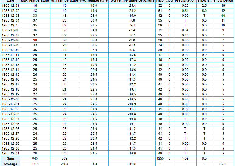
August 1968 is the biggest outlier month in terms of precip in our areas 130 year period of record. January 1985 is in the ballpark on the other end of the spectrum.
That year was wild. I was randomly reminiscing about December 1985's insanity the other day and trying to think if we've ever seen an example of a pattern getting as stuck as that one across the region. From the 14th onwards, The Dalles saw just a 7 degree temperature spread. Truly the mother of all inversions.
-
2
-
-
12 minutes ago, Front Ranger said:
Of course.
Just interesting how lame February was back then, especially compared to the recent stretch.
A lot of really insane -NAO blocks that decade so whenever +PNA did get going we had some pretty ridgy stretches. Like February 1963 and February 1968, both of which surprisingly were weak Ninas. We actually had regional 70 burgers in late February 1968 while Phil's house was an igloo.
-
4
-
-
20 minutes ago, the_convergence_zone said:
I moved here in August 2013 so I don't have any memory of the cooler summers, but I do have memories of complaints about the summer of 2011. That was near-universally hated "summer" from what I could tell, although I was at the UW at the time so most of the people I interacted with were transplants. Obviously there are at least a half dozen people on this forum who would disagree with that interpretation.
I think my wife would force us to move if a summer like that repeated itself, but I suspect that summer will end up being the coldest one of the 21st century.
Summer 2011 was very sunny and mild. Three solid months of mostly dry and beautiful, clear weather. I can't imagine anyone moving because of that June-September stretch. With the mountain snowpack also hanging on late it was some of the best our region ever has to offer.
April and May were quite chilly and gloomy, so people's views of that year maybe were clouded (literally!) by that. But most people who have lived here for awhile understand that those are transition months for our region and until recently could almost never be counted on to be barbeque weather months.
The problem is that recent transplants do now have a very warped view of those shoulder months since we have seen so many recent summer seasons like 2015, 2018, 2021, and 2023 solidly extend into the first half of spring.
-
8
-
-
20 minutes ago, TT-SEA said:
But Jim hates gloomy weather... doesn't add up!
Anyways... the upcoming pattern has me sensing no regime change has occurred (February delivers even in a Nino) and we are probably heading for another toasty summer.
1964 wasn't an especially wet spring and summer. Lots of clear, cold nights.
Not every cool summer is gloomy. The colder background state during the big -PDO phase in the 20th century also meant a lot more progressive patterns in the warm months where cold fronts would clip us from the NW and advect in cooler and relatively dry air behind them. I know you kind of interpret all of those years as uniformly cloudy/damp but the reality was often not that way at all.
Seems unheard of today I know since we've see-sawed towards having a stagnant 4CH dominate every aspect of our warm season pattern.
-
6
-
-
16 minutes ago, Cascadia_Wx said:
I was born right after the October-December 1985 cold fest petered out

Hot (for the time) May and August followed.
Your first July was pretty epic, though.
-
1
-
-
Just now, Cascadia_Wx said:
Jim was born 2/20/64. Coincidence?
I was just thinking that that was right around when the pattern shifted to perma-troughing over our region.
Nature knew.
-
4
-
1
-
February 2024 Weather in the PNW
in West of the Rockies
Posted
Same. Half of Slushy Inch could smile upon any of us, but I just don't see anything organized enough for much more.
Saturday OTOH looks like it could be semi-legit.