Clinton
-
Posts
6522 -
Joined
-
Last visited
-
Days Won
28
Everything posted by Clinton
-
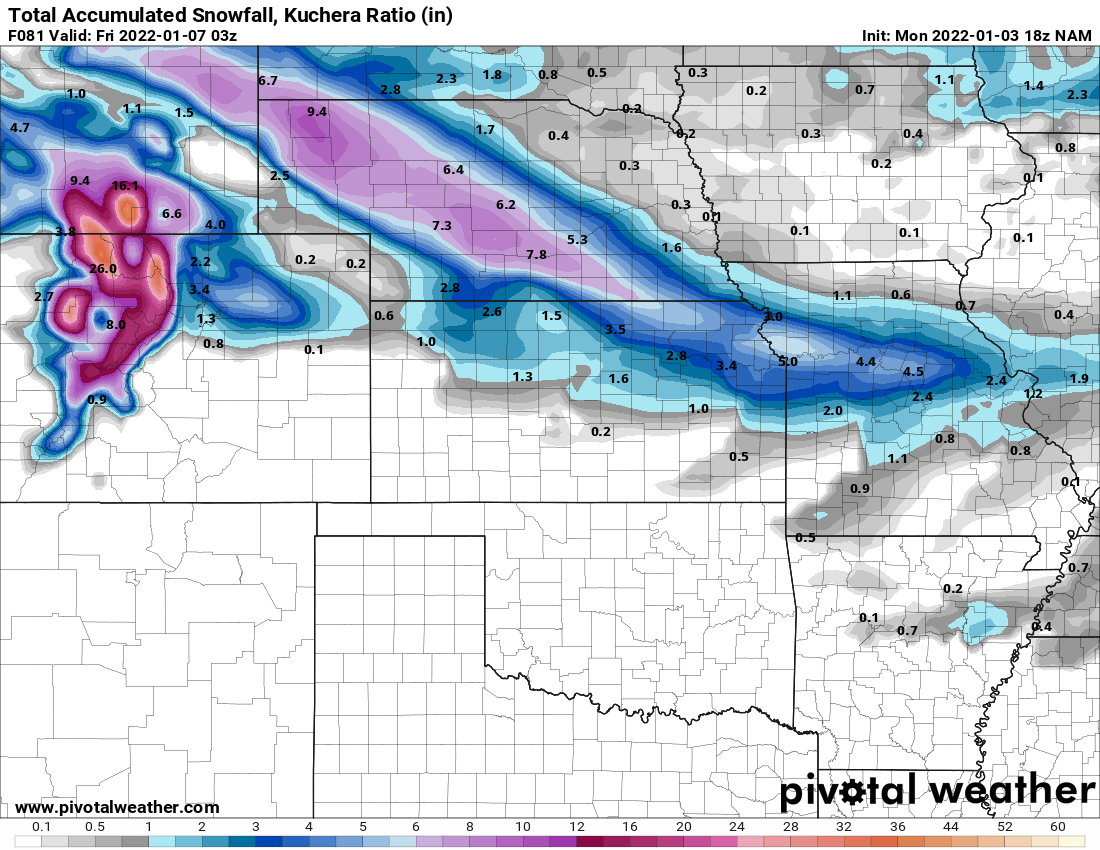
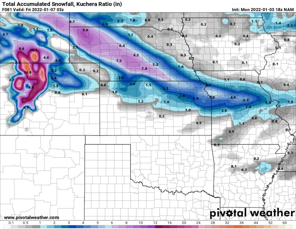
 12z NAM
 -
12z HRRR
-
The RAP has been consistent. 4 inches near mby
-
I'm right on the western edge of that bullseye but I would gladly take what it's getting me. The NAM would work for me and KC peeps as well. I also noticed the NAM seems to enhance the LES for Stacsh and delivers @Timmy_Supercella good snow.
-
3z RAP need not wobble
-
Chief Tonganoxie needs to reverse the curse.
-
I'm in the same boat, on that run I would get 1.5 while Henry, County would get over 6. I miss the days when we had better than a 50 mile wide band of snow.
-
I like how the NAM has been steady in producing accumulations, lets hope it goes north and widens out a little.
-
Lines up with what the KC office is saying. I do think there will be a band of higher accumulations somewhere near by. Sadly this would be our highest snowfall of the season.
-
18z HRRR is like threading a needle for KC
-
Global models say nada! Hi-res models are able to pick up this disturbance but there is no margin for error in KC. 15z RAP
-
12z HRRR not real trust worthy at this range.
-
12z NAM
-
6z RDPS
-
I hope so, it would be nice to get a few inches. The NAM has this feeding up your way kind of like your AFD mentioned.
-
12z GFS is starting to catch on to the southern storm
-
Got about a 1/2 inch of snow and sleet mix. It's amazing how storms have found a way to miss my area over the last few years.
-
Glad your on the road to recovery. This clipper seems to have eyes for your location, the 0z NAM gives ya a good snow.
-
18z RDPS. This looks like a real nice system for @CentralNebWeatherhope your doin ok.
-
Really good AFD from my office. With cold air firmly in place, the stage is set for our next round of wintry weather. Northwesterly flow aloft will allow for a clipper system to move southeast over the region. Models suggest the ridge over the West may be a bit stronger, pushing our storm system more northward into southern Alberta. This stronger ridging to our west may also allow the shortwave to dig further south as it moves over the Plains Wednesday night/Thursday morning. A deeper diving low would lead to a stronger system overall. Similar to yesterday, models that show a stronger mid-level shortwave trough, create more snow and take that snow further east. This is the case for the NAM, ECMWF and the Canadian. The GFS is fairly similar to its 12Z run from yesterday, depicting a weaker mid-level wave and weakening the snow as it moves further east. Given the agreement of the NAM, ECMWF, and Canadian, confidence is increasing in light snow moving through the area Wednesday night through Thursday morning. Forecast soundings show temperatures entirely below freezing. With cloud ice present, precipitation type will be all snow. But forecast soundings do show a substantial dry layer that will have to saturate before snow begins. This will likely occur late Wednesday evening into the overnight hours. Snow ratios also look slightly drier/higher than normal given the cold air in place. Factoring that all in, looks like snow amounts up to 2 inches will occur across the area, with some locally higher amounts likely. The main area of uncertainty is if and where any narrower band of snow may develop and the potential for a narrow band of higher accumulations. Given decent frontogenetic forcing, this looks like a real possibility. The NAM depicts a progressive frontogenetic band, most notable at 700mb, from southeast NE through northeast KS and through the forecast area north of the Missouri River. The Canadian shows this band further south and the ECMWF is just too coarse to depict that fine of a feature. This possible mesoscale feature will be handled better when the event gets into the time frame of higher resolution models.
-
KC office mentioning accumulating snow.
-
18z NAM holds the southern storm together and shows no end to the LES.
-
I'm keeping expectations low but the NAM did do good with the last storm. But ya this will be the time the GFS gets it right probably.
-
Storm on the east coast so the world is ending lol!
-
12z Euro is weaker this run. 10:1 map Wx Bell is currently down