


Clinton
-
Posts
6508 -
Joined
-
Last visited
-
Days Won
28
Posts posted by Clinton
-
-
Heavy rain the last 2 hours has the streams and rivers running. This is exactly what we needed!
-
 3
3
-
 1
1
-
-
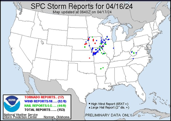
Looks like it's gonna be a fun night.
The Dominator 3 has arrived in Kansas City, MO for #tornado intercept mode with @nelkboysTORNADO POTENTIAL on Friday afternoon and evening maximizes first in eastern Nebraska into western Iowa ahead of the surface low. Short range models also show long track supercells from eastern Kansas into western Missouri, including near the Kansas City Metro. WATCH that dry line tomorrow. I wouldn’t be surprised if more of central and eastern Oklahoma could get storms.
-
 1
1
-
-
Another line of thunderstorms moved through overnight adding .65 inches, my storm total now sits at 1.75 in. More storms are lifting out of NW Oklahoma and SE Kansas and will be here later this morning. I'm hoping I can continue to get the big rains without getting my house blown down this weekend, an additional 3-4 inches look possible with severe threats the next 3 days. I believe tonight and Sunday will be my biggest threats for severe weather.

-
2
-
 1
1
-
 1
1
-
-
I got 1.1 inches with this first round of rain, more thunderstorms expected towards morning.
-
3
-
-
Nice soaking rainfall is ongoing, I have a little over a half inch so far and plenty of redevelopment to my west along the warm front. Rain and thunderstorms may continue through the night. This is great start with wave 1.
-
3
-
1
-
-
Omaha and Des Moines under the gun tomorrow. Here's a look at the EF2 composites

-
1
-
-
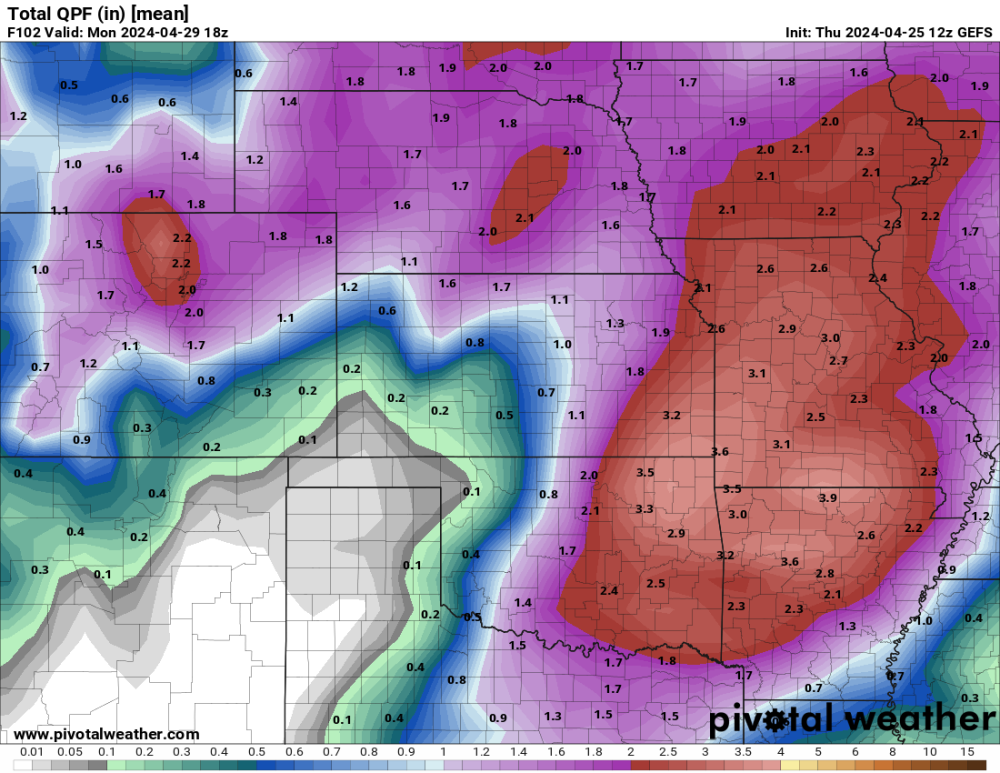
Light to moderate rain has move in. 12z GFS and some other models continue to show over 5 inches of rain over my place by Sunday evening. @Hawkeye I agree with Tom and believe you'll do just fine.
12z GEFS
-
2
-
-
It's been years if ever I've had a rainfall forecast like this 4-6 inches. Severe weather also possible 3 straight days with Saturday and Sunday being especially dangerous.
-
1
-
1
-
-
Big time storms in the KC area and mby Saturday evening. Dangerous setup hopefully everyone stays safe.
SATURDAY looks like a major #tornado outbreak across much of the southern and central Great Plains from northern Texas to Wisconsin!! Massive warn sector dominated by high-end kinematics on Saturday, after two days in a row of severe weather outbreak potential.We will be activating live storm chase mode tomorrow by around 4 pm.THANK YOU Team Dominator subscribers for making these storm chases possible!
-
Its been tough to get rain here also, I'm under 3 inches for the year. Hopefully we all will get some over the next 4 days.
-
 1
1
-
-
-
It's looking like the wetter pattern that will close out April will carry into the first week of May along the I-35 corridor. I'm ready to get the pool ready and the CPC favors above average temps to open May.


-
3
-
-
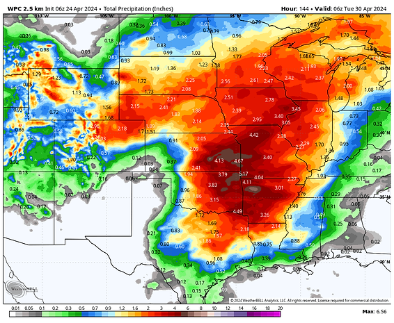
0z models all bullish on rainfall totals for just about everyone.
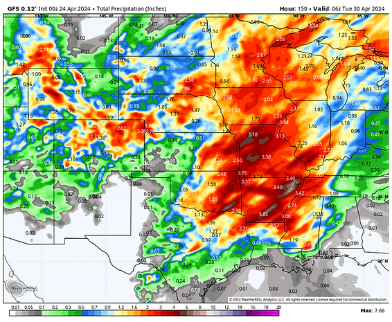

WPC forecast
-
1
-
2
-
-
Heavy rain and severe weather looking more likely for mby Thursday- Sunday. Friday and Saturday looking like the best bet for severe weather in my area. Sunday will likely be the biggest day of this event for severe weather but the action will likely be to my east.
EAX showing more rain in that time span than I've had this year to date.


-
1
-
1
-
-
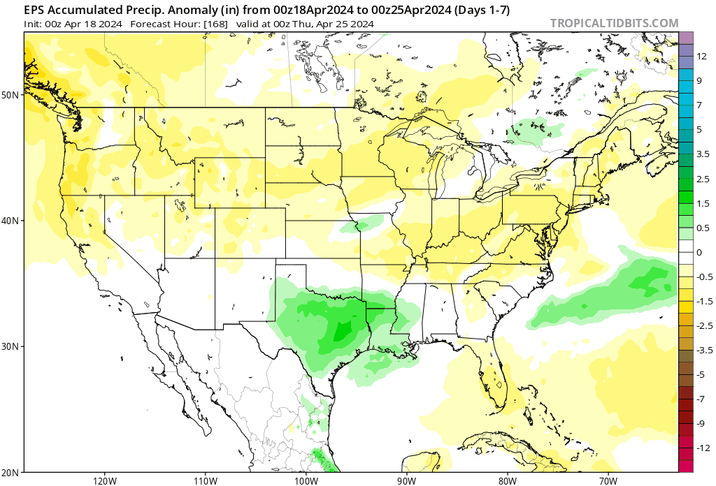
This is the part of the pattern that can put a dent in the ongoing drought and will likely produce alot of damaging storms. Here's some thought from Gary Lezak as this is by far the most exciting stretch of weather in this years pattern and he thinks 3-5 inches of rain over the next 10 day is certainly possible for the KC area.
Well, here we are almost 45-days after the strongest and most deadly severe weather outbreak in this year's LRC, March 12-14, and around 135 days after the other big winter outbreak in this part of the LRC, December 9th.
Do you remember this day in the previous cycle? 3 people were killed in western Ohio. This part of the pattern is cycling back through, one of our signature long-range predictions, in the next six days! If you know the LRC, then you know it is due around 4/28-
4
-
-
39 minutes ago, Black Hole said:
From Michael Ventrice using the GFS
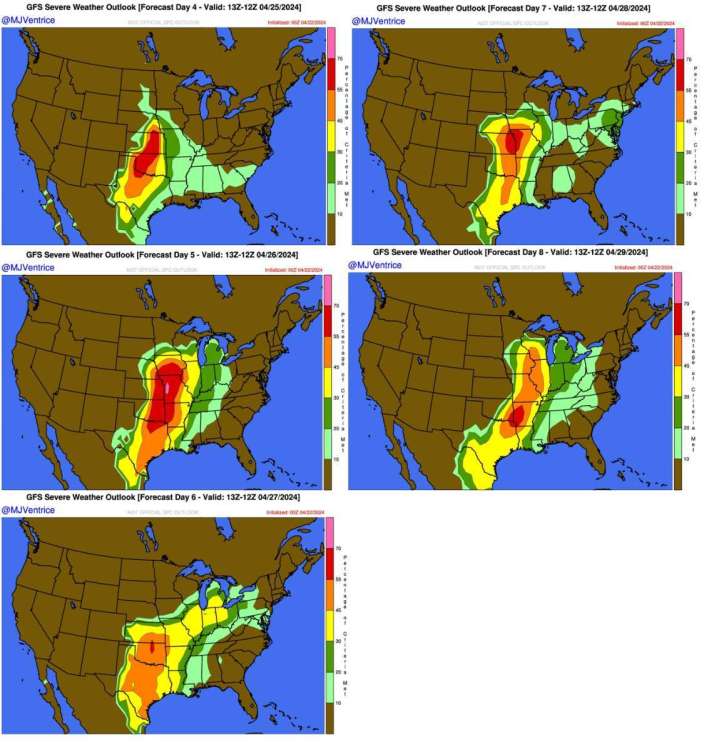
That day 5 looks intense for mby. Hope the timing works out so the storms don't fall apart as they get here and redevelop to my east.
-
2
-
-
4 hours ago, Tom said:
@Clinton the storm pattern targeting the West this week and then into the Plains really reminds me of the LRC's most noteworthy system (s). The 0z GFS from last night showed a run what has resembled a "Fujiwhara Effect" as there are multiple troughs digging into the SW region/Cali. I remember vividly these troughs delivering tremendous mountain Snows & Rain across Cali and the 4 corners. As you opined, a big ticket Multi-day Severe Wx is certainly on deck...I foresee this continuing well into MAY and even early JUN.
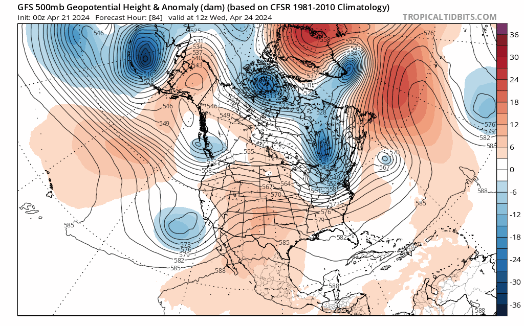
I hope it brings the rainfall as there should be 2 big troughs digging down before the end of the month. The SPC showing the severe risk later in the week. Another trough should dig down on the 28th and 29th, both will have lots of Gulf moisture.


-
1
-
1
-
-
No frost here this morning as temps only dropped to around 40. Lots of sun and a high in the low 60s today.
-
2
-
1
-
-
2 hours ago, OttumwaSnomow said:
Most of my 30 fruit trees in full bloom. Currently its 41F at 1 pm. Dewpoint is 27F and both will plummet down tonight i think my fruit is gone!
Somehow my cherry trees survived a frost when they were blooming and are loaded with cherries, not sure how my apple trees will turn out though.
-
4
-
-
Cool temperatures this weekend hopefully I can avoid any frost Sunday morning as temps may dip into the mid 30s. Later next week one of the stronger storms in this year's LRC will likely ignite a major sever weather outbreak across the middle of the country. Models are already showing significant amounts of rain in my area but it's gonna have to show me it can actually happen here in the show me state before I get to excited.
-
4
-
-
6 hours ago, Tom said:
It appears that the majority of the U.S. Cornbelt region will be blessed with a lot of moisture as we close out April. @Clinton you should finally fill up that watering hole of yours!
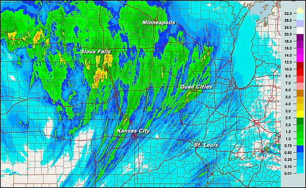
After looking at the overnight radar loops, our KC peeps did fairly well I'd say...#trainingstorms
Another disappointment with rain here only .22 inches. The rain just seems to find away to miss me.
-
 2
2
-
 2
2
-
-
A good amount of severe weather and rainfall from this system.
-
7
-
1
-
-
As expected not a drop of rain fell here yesterday however things are looking good for some beneficial rainfall tonight and tomorrow. The Euro and 3km NAM showing 1in plus for mby and the GFS just a little bit less. I could really use the rainfall, the strong winds yesterday picked up a bunch of dust and blew down trees including a apple tree in my yard.

-
3
-
-
Not expecting much rain here overnight or tomorrow. It's looking like Thursday may be my best shot. I'm so tired of drought!
-
4
-


April 24-29 Multi Day Central and Southern Plains Severe Weather Outbreak
in East of the Rockies
Posted
Another inch with this mornings storms upping the storm total to 2.8 inches. Skies are beginning to clear so we'll see what happens this evening.