
- Popular Post


Kayla
-
Posts
5926 -
Joined
-
Last visited
-
Days Won
14
Posts posted by Kayla
-
-
- Popular Post
- Popular Post
1 hour ago, SilverFallsAndrew said:Wow, not really sure what all the whining is about.
55 minutes later...
 5 minutes ago, SilverFallsAndrew said:
Pretty much no snow for NW Oregon now. Maybe a few dry 44/25 type days.
4 minutes ago, SilverFallsAndrew said:GFS and GEM are cold, but trending drier as well.
1 minute ago, SilverFallsAndrew said:Good day for team Tim.
-
 1
1
-
 1
1
-
 19
19
-
2 minutes ago, TT-SEA said:
12Z GFS is much less snowy for western WA going into the cold. Over the last two days... the focus on the snow going into the cold has been shifting south on the GFS runs. Previously over Whatcom County and SW BC and now over western OR on the 12Z run.
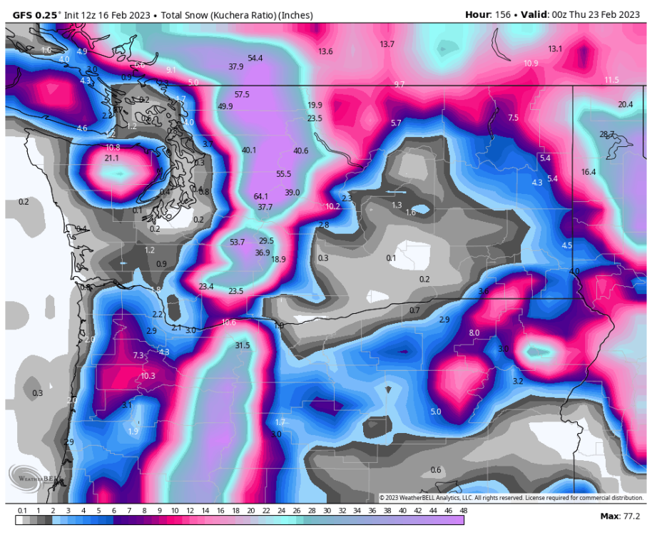
This feels like a south WV special to me. Very 2019 esque trajectory.
-
3
-
-
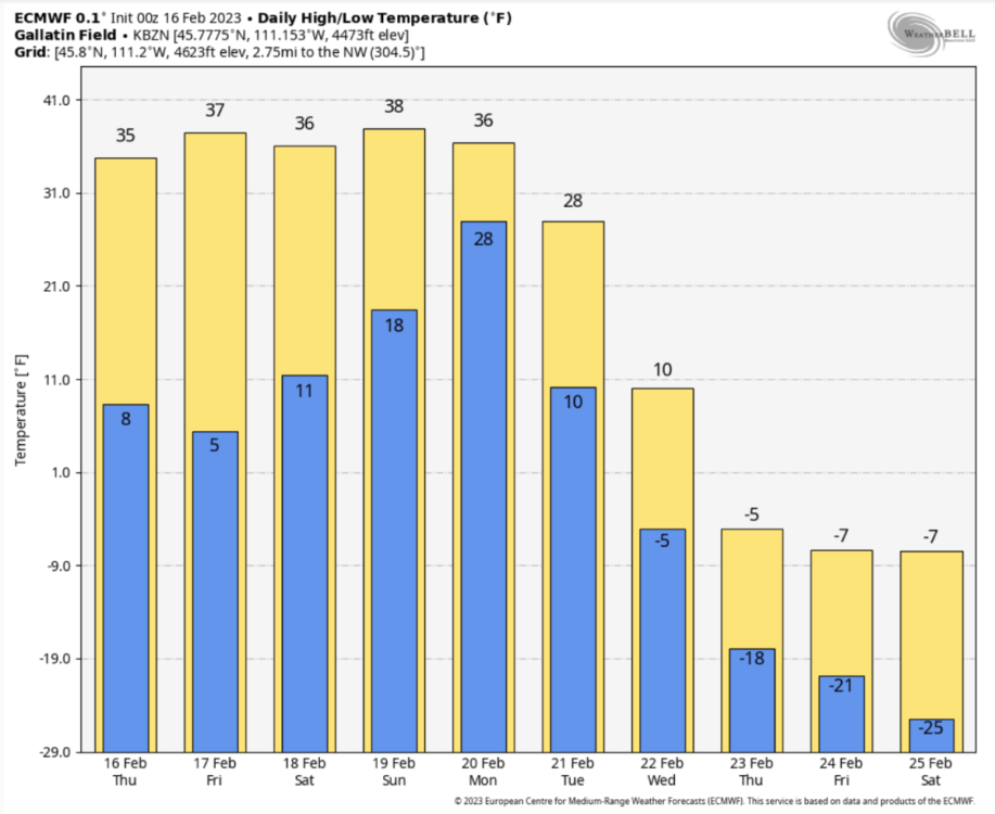
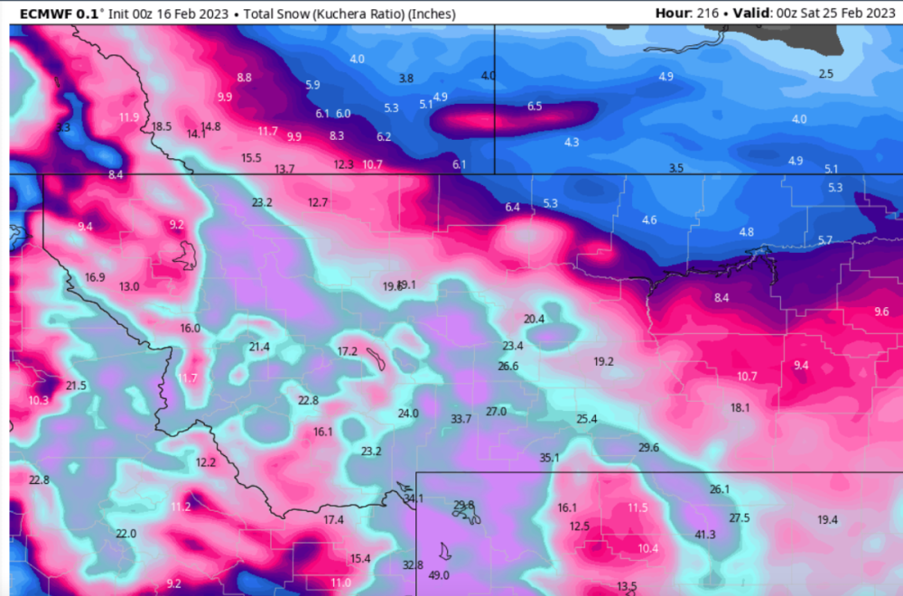
This would rewrite the record books for late February cold here. Only event that comes remotely close is 1962 and of course 2019. 1962 is the best match though. Those years never saw consecutive days with highs below zero either. Incredible stuff.
In terms of snowfall this event looks to compare to 2019 best. With that said, another 2-3ft of snow on already a 3ft snow base would be unheard of for here.
-
5
-
 1
1
-
 1
1
-
-
- Popular Post
- Popular Post
-4F here this morning. Beautiful bluebird morning!

-
17
-
1
-
- Popular Post
- Popular Post
25 minutes ago, Gradient Keeper said:Huh? Tell me you aren't really doing that. Are you seriously comparing what I said to what Josh has said? or to say I was empowered or allowed to do so because Josh was given such a long leash. That's just dumb. There are some overly sensitive people here who choose to be offended unable to properly manage your feelings or emotions, but if you listen to chick music, that's not surprising. You made the choice to be offended and type this ridiculous comment. Remember that. You made the choice.
Poor dig. Why are we so obsessed with binary things?? Music is music.
-
12
-
2 minutes ago, GHweatherChris said:
Third? For there...? Haven't even had one here.
Yeah, the west as a whole has already seen two Arctic blasts this season. You've had one solid one and you were brushed by the late January one.
-
6
-
-
The Euro is beautiful! Hard to imagine the region getting hit with the third Arctic blast of the season but it's looking more and more likely. What a season for the West!
-
3
-
 1
1
-
-
- Popular Post
- Popular Post
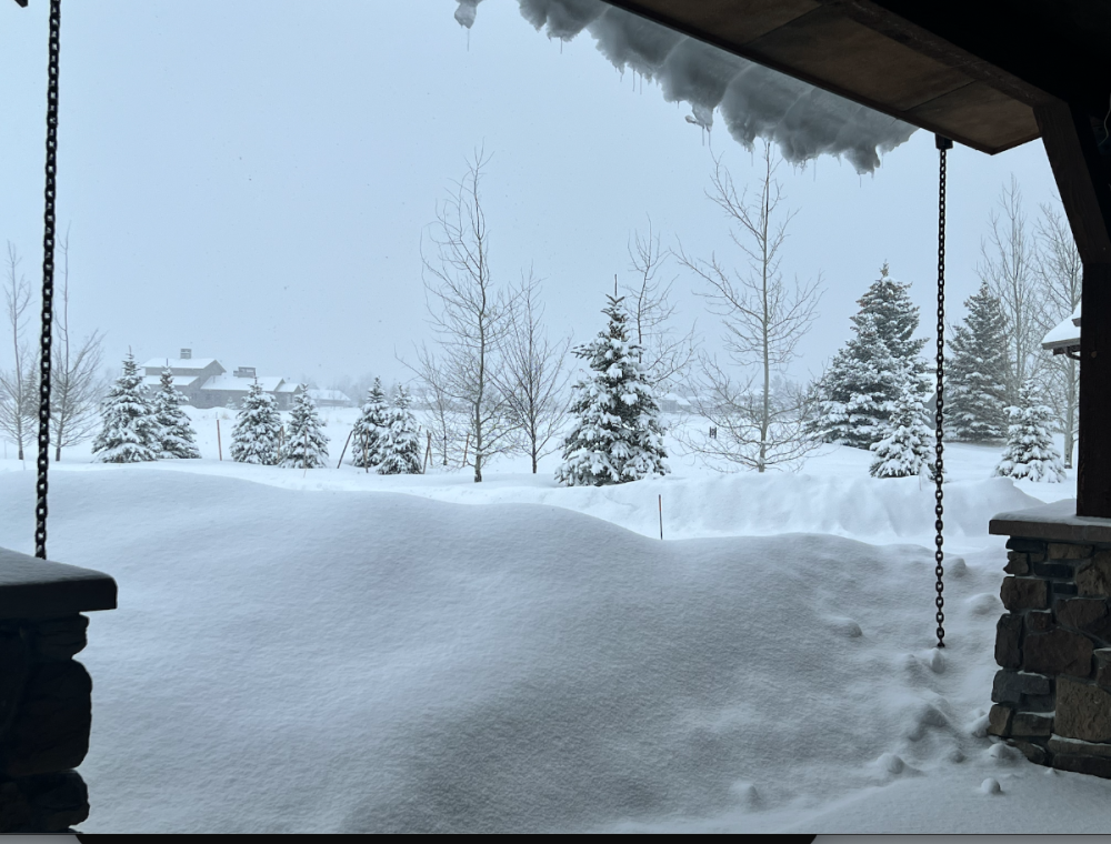
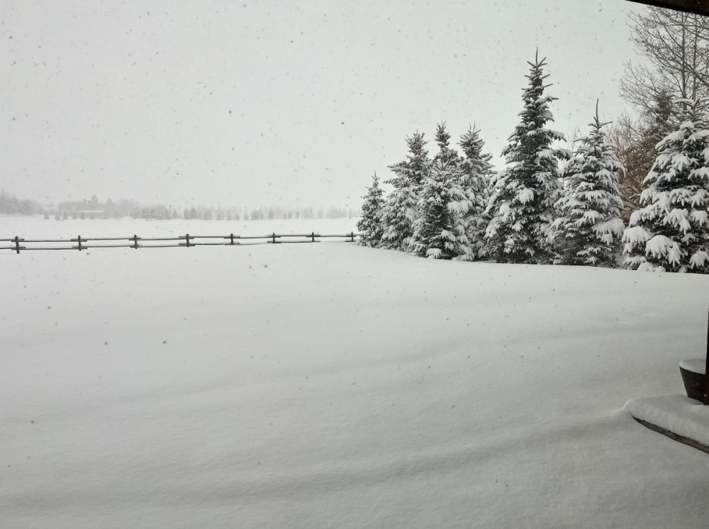
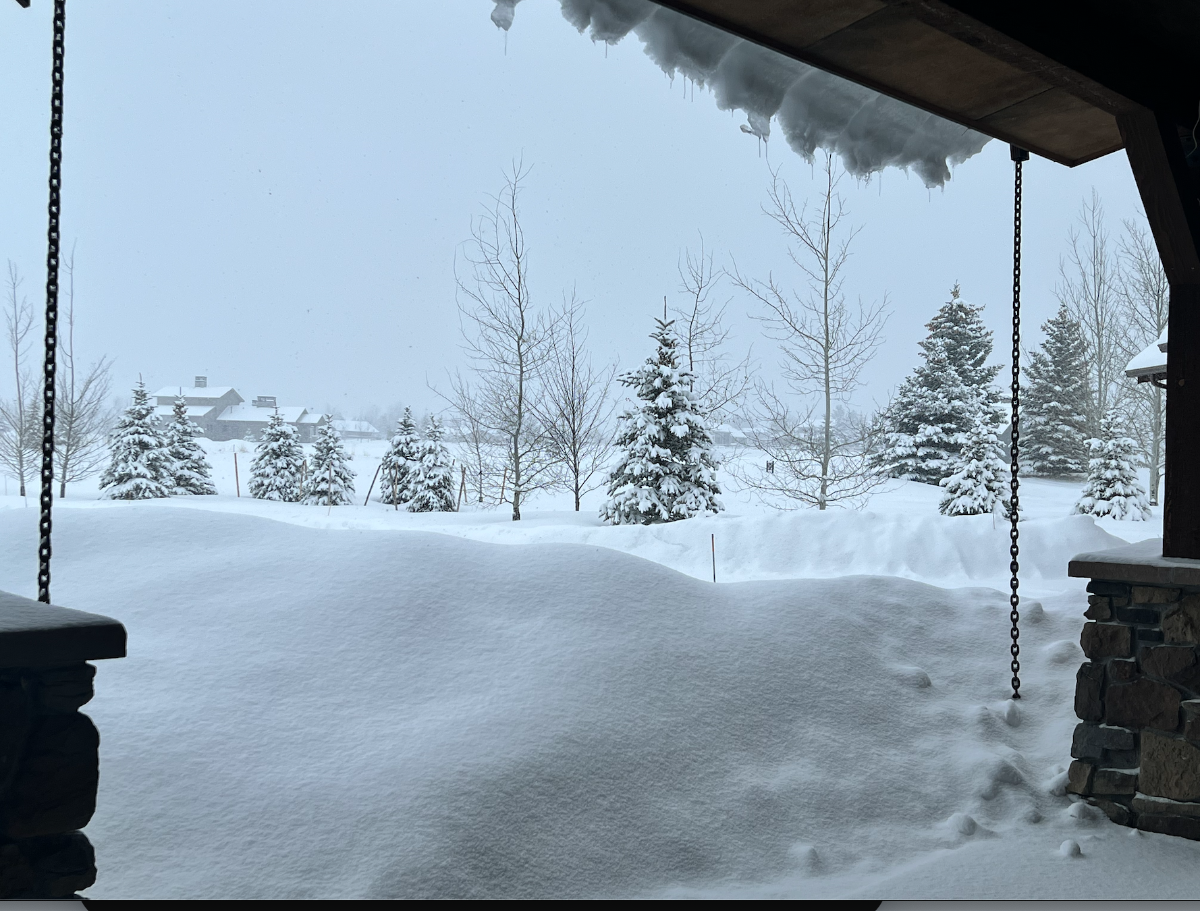
Picked up 10" so far with this storm. Still snowing heavily and 24F.
Back up to about a 3ft base. It's been quite the season. We've had over a foot of snow on the ground since early November with the brunt of the winter well over 2ft on the ground. Will likely have to wait until April to see our grass this year.
-
20
-
7 minutes ago, Perturbed Member said:
Mark:
"Models are still forecasting 850mb temps to drop down to -7 or -8 around sunrise Tuesday. Wind goes calm about the same time. A weak little surface low is sliding down the coastline later tonight; hopefully that southerly breeze ahead of it doesn’t keep temperatures up 2-3 degrees as the heavier precipitation arrives. That could be a snow killer and keep many of us in the TRACE range.
Models in pretty good agreement that most of us get at least a little snow. Our GRAF is looking a bit sparse and gives me confidence that 2″ is the high end. I live at 1,000′ and I’d be surprised if I get 3″. 1-2″ seems more likely up here. "
I haven't been following the models all that closely but the upper levels look good to me for 0.5-1" in that 6-8am time.
Probably safe to go to bed early tonight and plan on a 4-5am wakeup!
-
3
-
-
7 minutes ago, Slushy Inch said:
Usually looks about the same on Weatherbell.
Makes a difference though. 1991-2020 climate norms vs 2003-2022 norms.
Just something to keep in mind I suppose.
-
1
-
-
1 minute ago, SilverFallsAndrew said:
Yeah, obviously the trough isn't here yet at hour 240 on the operational, but it is on the move and heading south.
With already way too much overwater trajectory. That's just not going to get the job done below 1000' in late Feb.
-
3
-
 1
1
-
-
5 minutes ago, RentonHill said:
EPS Day 10 vs Euro
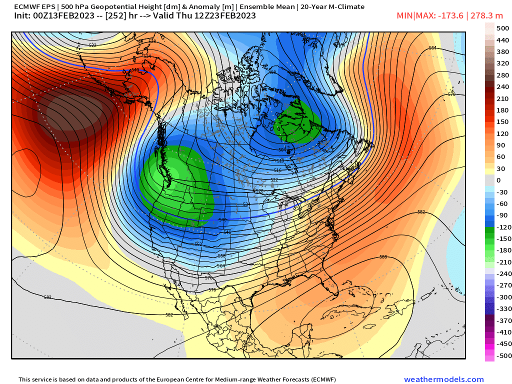
I just realized that those weathermodels maps are based off a 20 year mean. That's kind of making the anomalies look deceivingly great.
-
3
-
-
19 minutes ago, SilverFallsAndrew said:
Looks like the EURO is heading in the right direction at the end. It's just going to take it a little while to get in line with it's older brother.
Right direction if you like 1000' snow levels (which I know you do!)
-
4
-
 1
1
-
-
Under a Winter Storm Warning here for 8-12" of snowfall tonight through tomorrow morning.
Nice to see February coming through again. Bozeman is currently sitting with 82.9" of snowfall for the Oct-Feb period and we should move into the 3rd snowiest on record for the period by tomorrow. Even with the more active pattern upcoming, I don't think we'll quite catch the record of 109" set in 2017-18. That was quite the season for my first winter here!
-
7
-
1
-
-
7 hours ago, Gradient Keeper said:
Livingston, MT has had a lot of fun the past 24 hours.

I90 has been closed since yesterday morning from just past Bozeman to Big Timber because of all that fun!
-
1
-
-
28 minutes ago, Gradient Keeper said:
Livingston, Montana looks like the best morning I can find!
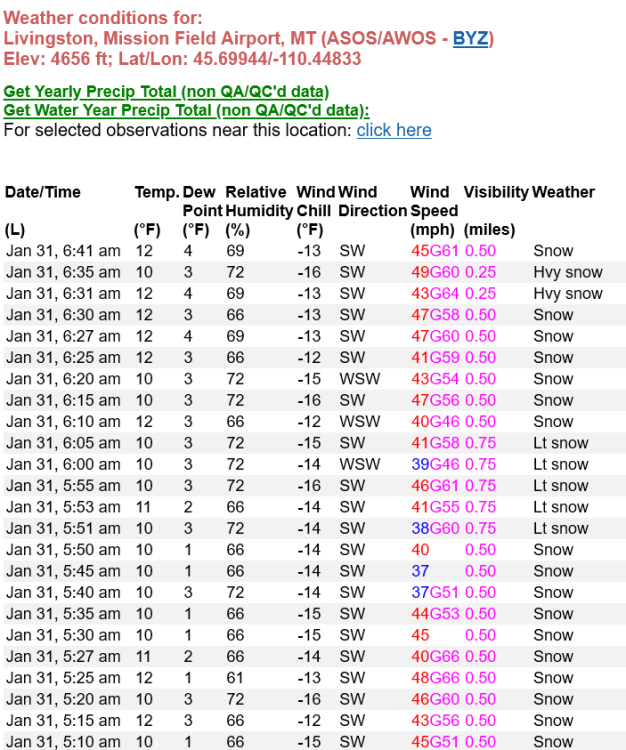
Windiest city in the country! Livingston is only about 15 miles east of me as the crow flies yet it’s dead calm here. The front range is crazy like that.
FWIW, it’s not actually snowing there/here. It’s just a full on ground blizzard and the sensor is picking it up as actively falling snowfall.
-
7
-
 1
1
-
-
Things kind of leveled off last night so I only dropped down to -21F. My spot has never been a very good cold air drainage spot being elevated from the valley. Makes the -40 I saw last month seem even more impressive. That airmass was beautiful!
Looks like the airport hit -30F.
-
4
-
2
-
-
1 hour ago, AlTahoe said:
The only comparable winter here so far for temps and snowfall would be 1992-1993. It's been a long time since we have seen sustained cold from early Nov into Feb.
Shhh this doesn’t fit with the narrative this winter.

-
1
-
1
-
-
21 minutes ago, BLI snowman said:
I think you're a bit clouded being in one of the relatively few areas that has done well. The torching has been almost ubiquitous so far thanks to the historic January (will likely go down as the warmest nationally since 2006). A warm February for the lower 48, which again looks more likely than not at this point, could potentially even put this winter over the top.
And the problem is that the northern tier areas really aren't all doing well either. A lot of the big northern population centers are looking at snowfall deficits, with the Northeast obviously being on the extreme side of things. Chicago, Milwaukee, Detroit, Cleveland, Boston, and of course PDX and SEA who haven't exactly scored in that department.
I would say Buffalo, Minneapolis, Denver, and Salt Lake City are the only large metros that have had "good winters" to date by their own standards, be it from snow or cold or both.
I can say the reverse about you!
 You keep referencing the midwest region when I never said anywhere that they are having a good winter.
MSP, FSD, DEN, SLC all fit within the area that I've been saying that have done well. Throw in places like RNO, TVL, FLG and you have a very large area of the US that is seeing a very decent winter. The areas seeing it are where we needed it most which makes it an even bigger win.
-
2
-
-
While looking at climate data (thanks BLI!) and I just noticed that Bozeman saw 147.8" of snowfall in 2022. Third highest yearly snowfall on record. Can thank the very snowy Oct/Nov/Dec for that!
Down to -20F here.
-
2
-
-
59 minutes ago, BLI snowman said:
Really gotta disagree there. Chicago has only had 13.7" of snow with little or none in sight. They're pretty far from either northern corner of the county. And the Plains south of Nebraska haven't done well at all. Wichita is sitting at 3.9" of snow and Kansas City is at 4.7". With a historically warm midwinter stretch.
The northernmost regions of the Midwest that aren't reliant on cold air availability at all have done well with the poleward-skewing storm track. Ditto for some of the high elevation areas in the Intermountain West. Otherwise it's been a warm and forgettable winter for most of the country, with a mild February looking increasingly likely.
You know just as well as I that it's rare (and getting more rare) for coast to coast cold/snow. Writing was on the wall for the northern tier to see a decent winter which is what we are seeing. To also see the SW score along with the Intermountain region has been a huge bonus which makes this winter a win IMO.
-
2
-
-
1 hour ago, BLI snowman said:
Pretty small percentage of the country, unfortunately. Though nice to see and much needed down there.
I still think you are generalizing it too much. The Plains have also done quite well. It's really just the northern corners of the country that have had limited snowfall/cold.
-
2
-
-
- Popular Post
- Popular Post
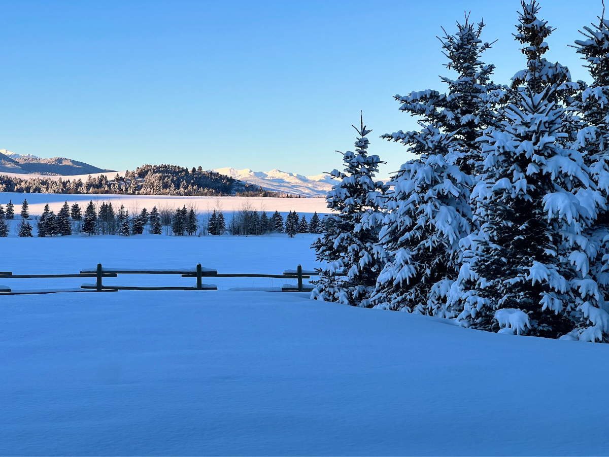
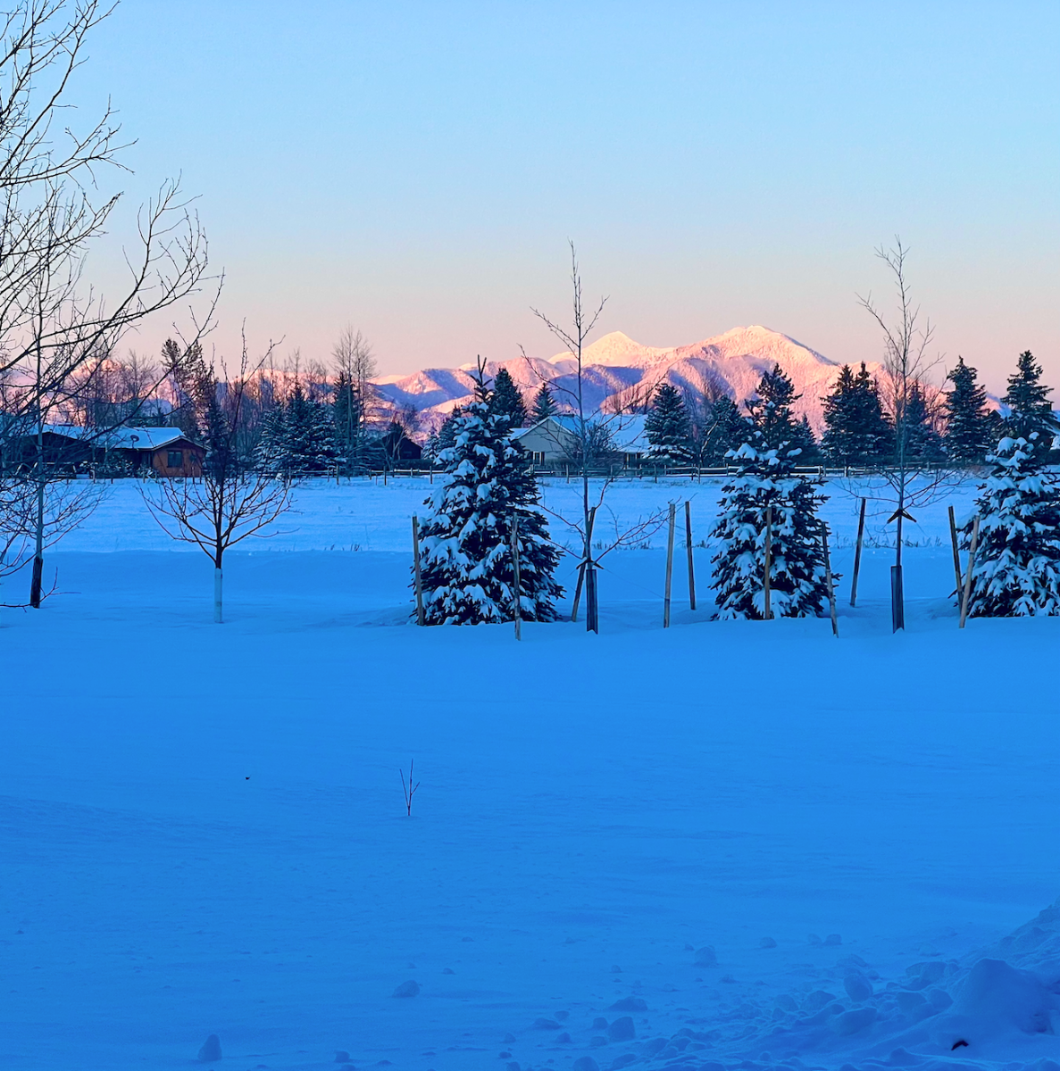
Gorgeous alpenglow on the Bridger's this evening.
Made it all the way up to -4F today but already back down to -15F currently.

-
17
-
1 hour ago, BLI snowman said:
It may well be a cooler than average month in this region, but that doesn't always mean much. By late February coolish onshore flow can easily give us cold anomalies. After this week there's no signs of another pattern favorable for driving arctic air into the region.
Nationally it's pretty clear that barring a freak March, this will be a very mild and snow deprived winter for almost everywhere.
The Sierras and Intermountain region are having a blockbuster winter.
-
1
-


November 2023 Weather in the PNW
in West of the Rockies
Posted
Hey soooo....what'd I miss?!?