


Kayla
-
Posts
5926 -
Joined
-
Last visited
-
Days Won
14
Posts posted by Kayla
-
-
12 minutes ago, Brian_in_Leavenworth said:
She once showed a picture of her house from the outside. Beautiful home. I warned her, though, to not share that picture too much or Hallmark will come knocking at her door wanting to film a Christmas movie there.
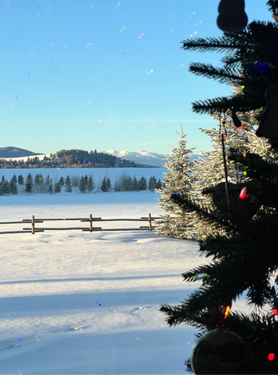
Appreciate that and we feel extremely fortunate. Our house does really seem to come to life over the winter and holidays. We can thank some smart real estate investments in Portland that allowed us to build such a house when building costs were actually affordable here!
-
 6
6
-
-
4 minutes ago, Meatyorologist said:
Bucket list item!! But as someone who has never been in subzero weather (0F in the Gorge in Dec 2008 is my record) I could not imagine tolerating -40F weather. But I'll try one day for sure!
Also good on uploading the video correctly, it's an embedded media artifact, not just an attached file

I always struggle with the best way to upload videos here so I'm glad to hear this way is the best way!
-
3
-
-
Pretty awesome thread from the Missoula NWS. The tech of GOES17 is amazing! Looks like several areas were darn near close to -60!
[1 of 5] Though we may not have that many surface obs to get complete picture of the cold... our satellite #GOESWest #GOES17 is watching us from over the #PacificOcean this morning! The following are images from it's infrared channel 13 (10.35µm) which displays surface radiation
— NWS Missoula (@NWSMissoula) December 22, 2022-
4
-
 2
2
-
-
4 minutes ago, MR.SNOWMIZER said:
The gfs was correct with the high pressure into Montana days ago.
Pretty wild. I think the GFS was actually probably more accurate on low temps as well. Euro definitely has a warm bias in the winter.
-
1
-
-
- Popular Post
- Popular Post
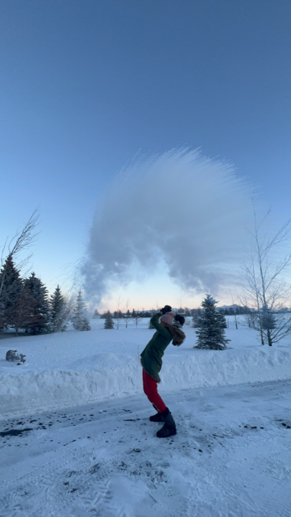
Did the thing on this -40 degree bluebird sky morning!
-
27
-
 1
1
-
1
-
- Popular Post
- Popular Post
Good lord, my station pressure is up to 1070 mb.

-
14
-
1
-
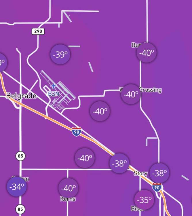
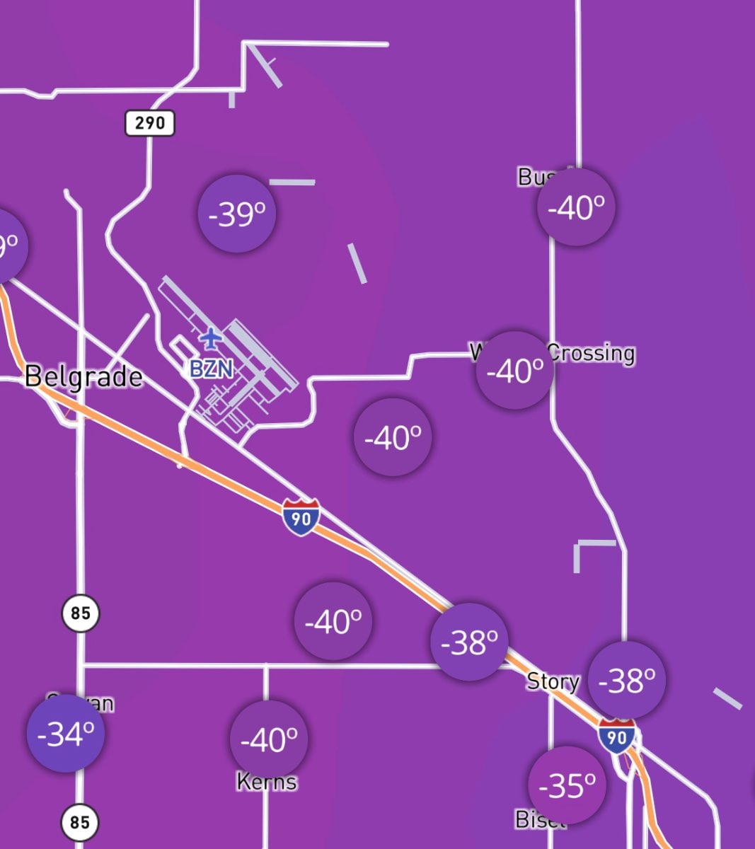
Officially -45 at BZN as of the 9am reading. Another new daily record low shattered from 1983. Just insane.
We now wait to see the inter-hour readings if they broke a new all-time record. I would imagine that they did.
-
5
-
-
- Popular Post
- Popular Post
1 hour ago, TT-SEA said:Its 17 in North Bend with an east wind and it painful to be outside and this would be a heat wave for you. I don't know how you do it. And I grew up in Minnesota! I have to say... I am glad this won't last long here.

I sometimes wonder that myself! It sure is beautiful from inside though!

-
10
-
- Popular Post
- Popular Post
I can’t believe I’m seeing this but it would appear that Bozeman MSU just tied their all-time record low of -43. Records go back to 1892!!

That station was originally in the middle of a wheat field now it’s smack dab in the middle of a large 16,000 student campus in the middle of a city of 50,000+ people!
-
24
-
Looks like a lot of stations around the airport have bottomed out at -40 since that is as low that PWS will record! Didn’t think I’d ever see that!
-
2
-
 2
2
-
2
-
-
- Popular Post
- Popular Post
BZN has been down to -43 this morning already. Oh so close to the all-time record! Some fog has developed there but they still have plenty of time to break it.
They did set a new record low yesterday of -34 breaking the record low of -31 set in 1983.
Currently -34 here and pressure is sitting at 1067 mb!
-
10
-
5
-
5 minutes ago, Meatyorologist said:
Competing with Jan 1950 or Jan 1880 here for cold potential would have me losing it. It's theoretically possible in this part of the city, but not the airport or downtown, not anymore at least.
Yeah it's been hard to wrap my head around what is actually happening right now. Fortunately the airport is still pretty remote but they have broken ground on a massive complex for shopping and hotels nearby so I'm sure we'll see the UHI take more effect there over the coming couple of years.
The downtown station (MSU) is probably already a lost cause but it still seems not horribly affected by UHI.
-
4
-
-
8 minutes ago, Meatyorologist said:
It may not mean a whole lot for Friday's precip type, but it does have quite the implication for our temperatures tonight. A deeper, more entrenched airmass means less clouds, deeper boundary layer, and less thermal energy in the lower atmosphere. Those differences compound and could allow for an extra few degrees of cooling.
I know I'm being a total weenie dork about the low temperatures tonight, but these kinds of rare instances of overperforming cold are growing even more rare by the year. And they are surrounded by an ever larger mass of heat records. I am relishing in this rare, precious win. Especially since the kind if cold potential tonight stacks big, right along our very best cold snaps even decades ago. That is something we haven't really seen in 12 years now, arguably since 1990.
It's pretty awesome. Really difficult to not geek out with this airmass!
Looking more and more likely that tomorrow will be the coldest day here since 1983 which has always been the crown jewel for cold. While this airmass is much more of a quick hitter, the fact that we are even competing for the single day all-time record cold from 1983 tomorrow is just insane to me.
-
7
-
-
3 minutes ago, AlTahoe said:
I was to young to remember that one.
I wasn't born yet!
-
55 minutes ago, AlTahoe said:
Crazy! Yet here at 6300' in the Sierra we are gonna be 50F tomorrow. All the other arctic air masses being listed like 2010, 2008 etc we were also cold. weird to have a top tier arctic air mass miss us entirely. I actually can't think of any others that did.
Yeah those dug a lot more to the SW over NorCal. This airmass is a lot more like 1983 where the arctic airmass is just north and east of you.
-
2
-
-
- Popular Post
- Popular Post
Temp now down to -31F!
-
13
-
1
-
 1
1
-
1
-
9
-
- Popular Post
- Popular Post
Already down to -29F here which is a new record low for me in my 6 years here. Skies are already quite clear and winds are slacking off. Pressure already down to 1056 mb.
Thinking we may even make a run at -40F here tonight. BZN is already down to -24F and MSU is also down to -24. All-time records for those locations are -46 and -43 which are amazingly under threat tonight.
-
6
-
1
-
1
-
11
-
10 minutes ago, Front Ranger said:
It's currently 50 in Denver. In 5 hours or so, should be sub-zero.
Denver takes the cake with the most wild swings in the country.
-
3
-
-
6 minutes ago, Doinko said:
Would 2018/2019 also be an example? The January 2019 blast for the Midwest and then the March 2019 blast for the Rockies. And the cold in February.
Absolutely. I was going to mention that one as well since recency is more important to me than perfect matches in our changing climate.
That January 2019 airmass was brutal in the midwest and then we all know what happened in Feb/March that year!
-
3
-
-
16 minutes ago, BLI snowman said:
-50+!? Don't think that happens too much anywhere outside of the northern Plains and some of the Rockies

1968-69 didn't really have anything too crazy for most of the lower 48 IMO. The extreme stuff was fairly confined to the PNW and northern Rockies.
1984-85 is a fairly good example of repeat big blasts in short succession. Mid January in the East and then early February in the western 2/3 of the country.
1978-79 is maybe the king for persistent and sustained cold in North America. The airmass at the end of December was huge and fairly historic in the West and spilled over into January. And then the East had their turn in February 1979 which was off the charts cold there, with a top tier airmass in the middle of the month especially.
1935-36 was similar but flipped, where the East had their turn in late December and January and then the western 2/3 of the country was off the charts cold throughout February 1936 from several different airmasses.
I think if you just looked at the top 15-20 coldest winters in the U.S. you'll find that a lot of them had repeat airmasses that were fairly historic at the 500mb level. Some winters just have that "it" factor when it comes to blocking.
Ha, looking at 1983/1990/1972/1989/1937 got me going on what years had two MAJOR blasts which also helped with really narrowing down the years.
Good stuff as usual. I totally forgot about 1978-79, that one was a beaut!
-
3
-
-
8 minutes ago, BLI snowman said:
Oh there have been a lot of years with repeat major blasts. Mostly older of course, but 2013-14 jumps out as a recent year with a ton of major airmasses dropping down. 1995-96 had a lot of repeating action as well.
December 1983 has been brought up recently due to this week, and even though it was a close shave for the PNW, the middle part of January 1984 featured another major event that stretched out similarly across the entire continent.
I guess I'm still struggling to see many years with two events that produced -50+ departures over a large swath of the country though. Maybe 1968/69 as well?
-
1
-
-
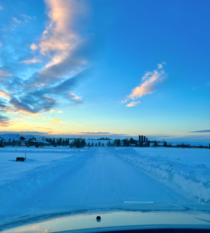
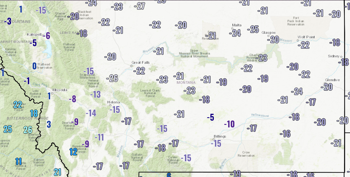
Quick check of mid afternoon temps before things really plummet late this afternoon and temps have really not budged anywhere. Many have even dropped since late this morning.
-20F at my house at 2pm in the afternoon is not something I expected to see!

-
5
-
1
-
-
3 minutes ago, MossMan said:
2006/07! (At least in my backyard)
Ha, I wouldn't call either of the blasts in 2006/07 historic for North America though!
-
1
-
-
54 minutes ago, MossMan said:
We are going to get nailed again this winter, sometime between January 15th and the end of February, but my guess is the second half of January.
What is the precedent of two major North America blasts in one season? Off the top of my head I can only think of 1962 and 1972/73.
-
2
-


PNW December 2022 - Part II
in West of the Rockies
Posted
Yeah you really need at least -20F to get it to work properly. Glad to hear that you gave it a shot though!