


mlgamer
-
Posts
802 -
Joined
-
Last visited
Posts posted by mlgamer
-
-
On many model solutions this morning I only need a south shift of even 30 miles to get in on the higher totals. So near yet so far...
-
 2
2
-
-
2 minutes ago, MIKEKC said:
Speaking with Lezak this morning, he said if the ULL is strong, it likely cuts harder and KC gets dry slotted with little accumulation. Bigger snows will happen in NEB and Iowa...but, if it shears out, it will go SE more and favor KC to get accumulating snow, not a big storm, but a 1-3 inch snow...
This is what the models have been showing all along.
I'd rather the guys up north have a stronger storm to enjoy rather than suffer through another 1" nuisance snowfall. Bring on Spring and let's be done with this garbage winter (here anyway).
-
1
-
-
20 minutes ago, Clinton said:
Models have trended so strong with the first storm that its only leaving scraps for the second. Also the front looks strong and is kinda shearing out the second storm. At hr 84 the NAM looks very positively tilted and stretched out.
I agree Clinton. Back in the glory years of old the first storm would be weak, but just strong enough to put the cold air in place, while the second storm would be the strong one to deliver the goods. It is hardly ever that way anymore it seems.
-
3
-
-
Looks like pretty much a done deal that Topeka to the KC area will miss out on this one. Nothing new really.
-
2
-
-
Don't know if anyone mentioned it, but Jim Flowers turned his Facebook back on. Looks like he plans to do things on a more limited basis.
-
4
-
-
Now we have the usual situation where I need the models to trend south only to see them remain locked in or trend further north. Call it the Cardinal Rule of Topeka Weather.
-
2
-
-
-
27 minutes ago, Clinton said:
Early thought from the KSHB team in KC.
Next chance of heavy snow
There will be two systems that try to pass by next Tuesday-Friday.
The second system is the one to keep an eye on for more accumulating snow as it will follow a similar track to the one that just came through.

I'll admit, I don't have a very good handle on the LRC this year, but I can easily see this system becoming a Dakotas, Northern Nebraska special based on what has transpired this year and the subtle trends and hints coming from the models. I think the GFS, GEM, and ICON already have this pretty much to the north of me with only the Euro nearby.
Not trying to be a pessimist, just trying to keep it real (for my own sanity if nothing else...lol). Still, it will be interesting to keep track of model trends and see how this eventually plays out.
-
5
-
-
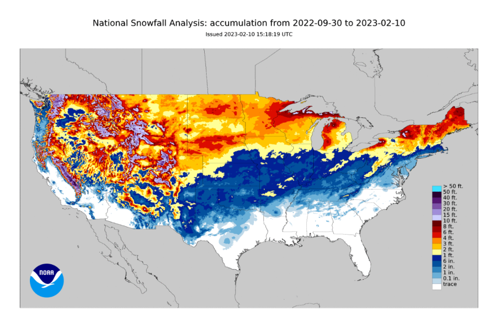
Looking at the latest scorecard, the I-70 snow shield is holding strong from central KS into Indiana (along with the Omaha area snow shield). Will that change before the end of the season...I dunno.
-
6
-
-
I laughed out loud when I saw the 00z 12K NAM moved the entire precip shield to the southeast of me. Over 1" of QPF on recent runs reduced down to less than 0.05". It's hard to take any of this seriously anymore. Local Mets must be wondering why they ever chose this for a career.
-
4
-
-
2 hours ago, Clinton said:
EAX not mentioning any chance of snow here next week. A little bit surprising given the trends on the Euro and CMC. NWS is telling the same story as the GFS, we shall see if that's a wise choice.
Topeka NWS AFD mentions the Euro snow but says too much uncertainty to add to local forecasts. Also mentions possible light snow with the trailing second trough.
-
1
-
-
2 hours ago, Clinton said:
Man I miss those years. Nice snows that stuck around more than 2 days.
Topeka had (I think a record) at least 1" of snow on the ground for something like 54 consecutive days in one of those winters in the early 80s. Hard to believe.
-
4
-
-
2 minutes ago, CentralNebWeather said:
We were having our 5th or 6th massive snowstorm storm/blizzard when you had that ice storm. The winter of 1983-1984 is still remembered around here for snow and record cold. I was in Junior High at the time. Many snow days.
Those winters of the 70s into the mid 80s were awesome! Wish they'd come back...lol
-
5
-
-
40 minutes ago, jaster220 said:
I clearly remember the cold and snowy March. Odd that I cannot remember the warmth of Feb. Especially since I had just finished rebuilding my first snowmobile as a teenager and was keen on whether we were getting good riding conditions or not?
We had one of our very worst ice storms here in March, 1984. I remember it very well.
-
3
-
-
It was nine years ago today that Topeka had a snowfall of greater than six inches. Nine years.
13" of snow fell on February 4, 2014.
Areas 15-20 miles to the east have done better than that...but not here.
-
3
-
 1
1
-
 1
1
-
-
- Popular Post
- Popular Post
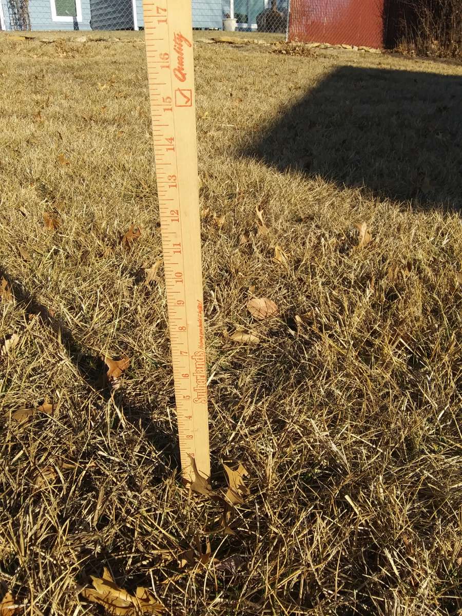
Went out to check on the snowpack this morning. Looks to be pretty close to 0".

-
2
-
 1
1
-
 9
9
-
 2
2
-
Weather Fun Fact Time!
Topeka has recorded 5.2" of snow this season. At this same time last year, we had recorded 5.1" so yes we are ahead of last year by a tenth!
We picked up 16" more last year to finish with 21.1" for the season total. I'm betting the under this year.
-
3
-
-
2 hours ago, Bryan1117 said:
I mean look at that nice “snow hole” near Omaha… that’s just funny and awesome at the same time!
For some reason you guys have been lumped in with normal Topeka "winter" weather this year. Not sure what you did to deserve it but it must have been pretty bad.
-
1
-
1
-
-
The NE Kansas Weather Rule is storms that are north trend further north and storms that are south trend further south. Call it settled science if you will...lol.
Hope those in the path score big! I'm out...can't get excited about yet another 0-1 incher.

-
2
-
1
-
-
Had 1" of snow on the ground this morning from the overnight snowfall (I feel like I'm the King of the 1" Snowfalls!). It was stuck to all of the trees and everything like the pic @OttumwaSnomow posted earlier. Very pretty and picturesque.
-
4
-
-
We have had a nice gentle snowfall at times this morning but nothing falling at the moment. No accumulations as temps have been too warm. Temp is currently 35.8 in MBY.
-
1
-
-
Just now, Clinton said:
Not an LRC match but similar type storm, unless @Tomsees something different. It would be a week late but it sure looks like it. Crazy how you have lived on the edge with storms. When I was younger it seemed like the shoe was on the other foot and your area was a magnet for storms and I was always on the edge.
Yeah, it didn't seem like an LRC match to me but it was definitely a wet storm that looked similar to this one.
Another thing is it seemed the severe weather also shifted away to the east along with the snow. We always had lots of severe weather to go along with the snowy winters back in the day. We've had not much of either overall for seemingly 20-30 years now.
-
2
-
-
39 minutes ago, Clinton said:
It's going to be a close call for you with the 24th-26th storm. I hope you end up on the right side of things. We had a wet storm come up from the Gulf in November seems like the I-70 corridor did well.
That sounds to me like the Nov 26/27 storm which gave me 0.40" of rain and much higher amounts to my south and east towards your way. I'm kinda lost on the LRC cycle length so I don't know if that matches up or not. I did ride the edge on that one. Never a dull moment, huh...lol
-
1
-
-
As things stand I don't expect to get much if anything out of either the Jan 21-22 or Jan 24-26 systems. Holding at 3.1" of snow for the season and probably will stay close to that for the time being.
-
2
-

2/14 - 2/17 Cutter and Panhandle Hook
in East of the Rockies
Posted
Southeast Iowa is in the WSW but it is being hidden on the map by the Wind Advisory. At least I think that is what you're alluding to.