


AbbyJr
-
Posts
629 -
Joined
-
Last visited
Posts posted by AbbyJr
-
-
12 minutes ago, snow_wizard said:
I sure wouldn't rule anything out with the massive SSW event that is about to unfold. Feb has been our month in recent years. That having been said it could well be over. I just think it's kind of short sighted to be so sure it's over.
I'd like to hope for another round of cold and snow but I'm just not seeing any strong evidence for a -PNA pattern.
-
20 hours ago, Phil said:
The upcoming +PNA will attack the PV and possibly force an early/dynamic final warming.
It might be too little too late, but if we do pull off a top-tier dynamic final warming, the niño tendency towards warm/dry springs in the NW US could be muted to some extent.
That said, it didn’t work out that way in 2016 (which was the last such occurrence). Niño might be too strong/stubborn.
The two cases where I recall March performing exceptionally well in the PNW were 1951 and 2002. Both were cold neutral. I'd be very surprised to see a cold March in the PNW during a strong El Niño even with a SSW/PV split.
-
 1
1
-
 1
1
-
 1
1
-
-
3 hours ago, Phil said:
Yes that is a split.
Yay I'm learning. Thanks Phil.
-
1
-
 1
1
-
-
1 hour ago, Phil said:
That’s not a split.
This, however, is a PV split, correct me if I'm wrong?
By the way, I'm not saying this is likely to verify. Just pointing out the raw data.
-
2
-
-
7 hours ago, Phil said:
Blech. I want nothing to do with a niña transition during descent phase of +QBO. Would be 5+ consecutive months of torching here.
If we do transition to a niña then yes it would have a higher chance to produce a cooler outcome in the West versus recent years. But I don’t think it’s a guarantee that we do transition, by any means. Multiple potential failure modes that could lead to a neutral ENSO outcome.
Even if we only make it to neutral, that can still work out well for the PNW if the QBO goes positive. The 1990/91 winter was a neutral/+QBO and produced multiple top tier arctic blasts in the PNW. I've always understood that during neutral years, the ENSO doesn't really play a big role in the upper level pattern. Therefore, such winters can be full of wild swings.
Do you think there is a good chance the QBO will go positive by next winter?
-
23 hours ago, Phil said:
I’m not bullish on early Feb in the NW because historically speaking, subpolar canadian blocking above STJ extensions tends to drive colder ULL/TPV features offshore into the GOA.
I’m more interested in what happens mid Feb onwards, when a more coherent Alaska block and -AO type pattern tries to establish while the jet begins retracting.
Could something similar to February 2018 be a possible solution for mid February in the PNW?
-
13 hours ago, Phil said:
May or may not work out in any given region, but it does seem likely we’ll see another round of high latitude blocking starting mid-Feb, as momentum loss begins and the pacific jet slows (waves break into AK and Greenland again).
Of course AAM will be higher than Jan event, and the PV will be stronger, so odds of a top-tier cold outbreak are lower, but it could still get interesting. But will probably be slightly more progressive overall.
The good news is that we don't need a top tier arctic blast from a PV lobe in order to get cold and snow down to the lower elevations in SWBC. February 2017 was one example of how a medicre outflow event still produced a very snowy pattern in the low elevations. In fact, Abbotsford recorded its highest snow depth since December 2008 during that event. While temperatures were marginal, many areas saw significant snowfall as a low pressure system stalled off the Washington coast and interacted with a modified arctic airmass. Run of the mill cold but top tier snowfall was the outcome.
-
2
-
1
-
-
56 minutes ago, snow_wizard said:
Very good chance next winter will be yet another one to have an Arctic outbreak. So far this decade has already had 5. That's not even counting the Jan 2020 event which was pretty substantial north of Seattle.
It's possible but there have been many La Niña events that did not feature an arctic outbreak in the PNW.
-
1
-
-
Trends?
12Z Today:
00Z Last Night:
12Z Yesterday:

-
3
-
-
26 minutes ago, Phil said:
During the 2nd half of niño winters, that undercutting STJ/trough beneath the Canadian ridge is indeed the easiest way to achieve cold anomalies.
So it’s worth watching, at least. Getting the vortex out of Alaska is integral to that evolution, though.
There is a good chance the PNW could get chilly in mid to late February but I'd be surprised to see any legit arctic air.
-
2
-
-
4 hours ago, ShawniganLake said:
Yea. I agree. I think the odds of arctic air going forward is very low. Even with ENSO dropping off, there is going to be some seasonal lag. Some mountain snow would be nice. Sort of reminds me of 2005 right now. The mountains here have about as much snow at 3000-4000ft as we do near sea level.
Agreed. But I think next winter has a lot of potential if we do end up crashing back into La Niña and the QBO goes westerly. La Niña/+QBO is usually a good combo for PNW cold.
-
2
-
-
1 hour ago, Phil said:
I wouldn’t say that yet, but February is probably a lost cause now. Unless there a massive, systematic error in guidance over Eurasia during week-2.
It’s extremely rare but March has sometimes performed in the PNW. 1951 and 2002 are a couple examples. Though they were both cold neutral. This year we have a strong El Niño making a cold outcome much less likely.
-
2
-
-
2 hours ago, Phil said:
There’s more that goes into these reanalyses than just the ET/500mb pattern. You’d think 2016/17 was a strong niña based on how the 500mb pattern played out, but in reality it wasn’t a niña at all (Jan onwards).
Ha, I’d never actively root against you guys. If anything I’m empathetic since you guys struggle as much, if not more than we do in this climate era.
If I was going to root against anyone it would be Scandinavia since troughing there is a winter killer for all of North America.
Oh yeah, we’re all gonna torch for the next 2-3 weeks. Or at least average well above climo. Alaska and Greenland will score, though!
There’s a chance we could sneak a southern stream system in here without cold (technically it can snow here with above average 850mb temps) but that is threading the needle and usually doesn’t work.
Less than here, but yeah.
It’s the GFS, bro. There won’t be much if any cold in Canada in a +EPO/+PNA pattern. Alaska will probably get cold, but it’s at everyone else’s expense.
And it’s probably correct. Essentially repeating the subseasonal evolution of December (with some minor differences, of course).
At least North America was able to score mid January with that SSW event. Back to El Niño.
-
1
-
-
12 hours ago, Phil said:
God I love winter. I’m not ready for big thaw next week.

We’re about to waste 2-3 weeks on a Pineapple Express pattern thanks to the big AAM spike & WPAC MJO. Basically a repeat of the December pattern.
The big thaw is happening here too. We are all in this together.
-
14 minutes ago, Phil said:
It wasn’t the crash in ENSO itself, but the +QBO and augmentation of off-equator NPAC convection (which is associated with -ENSO and +QBO, but also +PMM to some degree) that amplified the Aleutian High throughout the winter.
(Let me know if I’m using too many acronyms, I’m low on time at the moment and rushing a bit).

If 2024/25 is a healthy Niña, then yes, an amplified Aleutian High and cold PNW winter is likely given the +QBO (and favorable timing of westerly shear).
The exception to that would be if we have an asymmetrical +IOD such as 1999/00. Which for all intents and purposes is what we have now (tho different relations with that in Niño vs Niña winters).
All that being said, the next intradecadal extension of the IPWP is coming soon, so if next winter ends up being a Niña, it’s likely to be a single year event. And +ENSO is likely to dominate the second half of the 2020s.
No problem Phil, thanks for your explanation. It's all good. While I don't always understand your acronyms, I get the gist of what you are saying. Do you think there is a solid chance the IOD could go negative by next winter so as to avoid a 1999/00 outcome?
-
50 minutes ago, Phil said:
What does “like 2016/17” mean?
Little known fact is 2016/17 was not a Niña winter at all. Sure, it started out with a weak Niña low frequency signal, but that collapsed entirely by January.
The second half of that winter featured a hybrid Niño-Costero low frequency signature and +PMM/+PDO signature in the off-equator circulation. It was bizarre and something few expected going into the winter, including myself.
Then, as if nature was intentionally trolling, the niño-costero regime collapsed and inverted into a moderate east-pacific Niña and +PMM during the summer of 2017, which once again caught me off guard.
I remember being extra salty because I never saw that coming, even as it was happening, and that entire summer played out contrary to how I expected it to.
When I said "like 2016/17" I was referring to the persistent cold and snowy pattern. December had an early lengthy cold wave with multiple low elevations snows. January had a few arctic outflow events, and then there was a major snowy pattern in early February with several days of heavy snow. Even March had a low elevation snowfall here in SWBC. The winter seemed to be dominated by high latitude blocking and western troughing. Perhaps I misunderstood you but a while back I recall you mentioned that the sudden crash from the super El Niño in 2015/16 to La Niña was one of the reasons the PNW did so well cold and snow wise in the 2016/17 winter. Since we might crash back into La Niña, I wondered if a similar outcome could unfold.
I'm not sure how one could say it wasn't a La Niña winter when the SST's in the Nino 3.4 region were below normal.-
1
-
-
If we crash back into La Niña by next winter and the QBO goes westerly, do you think the outcome could be similar to 2016/17 for the PNW?
-
2
-
-
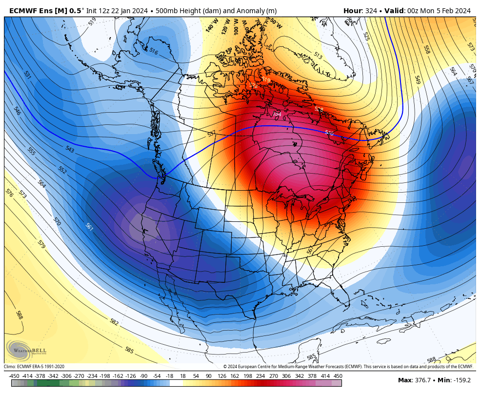
8 hours ago, Phil said:
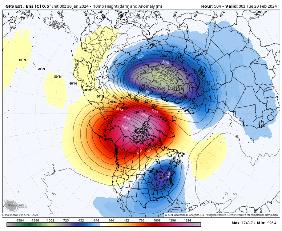
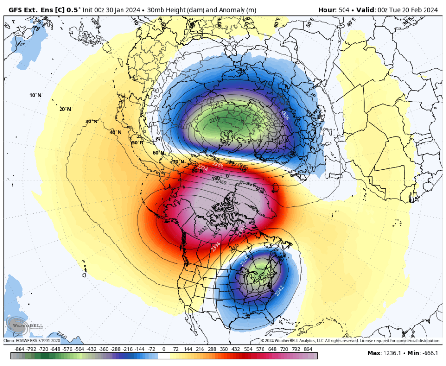
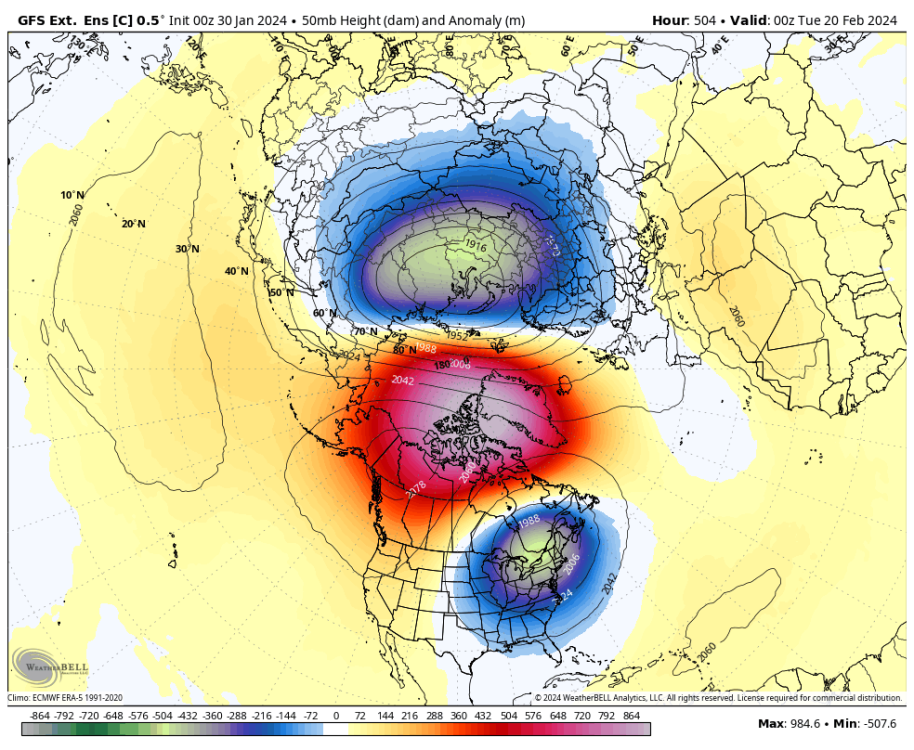
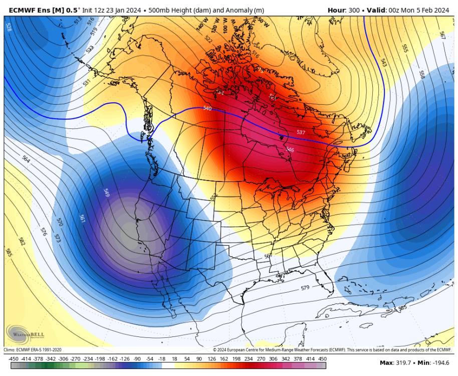
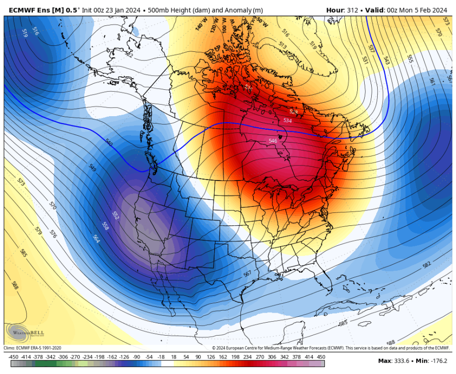
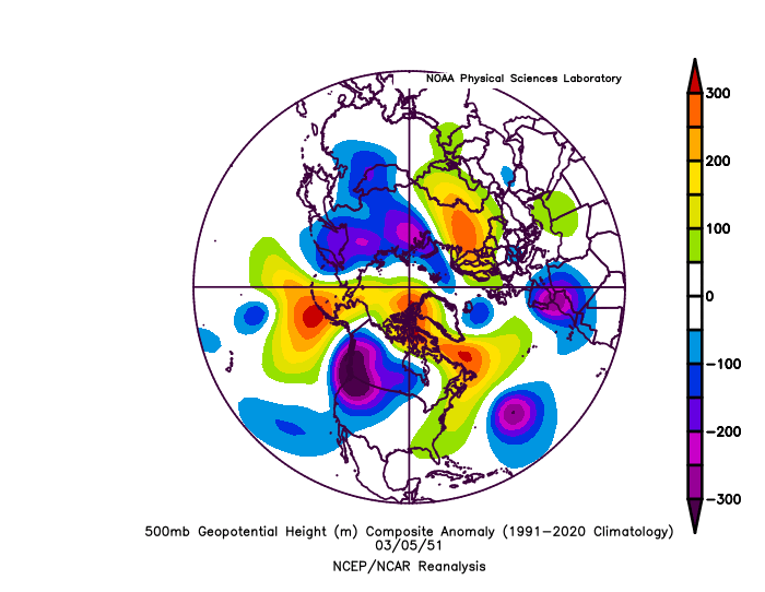
The SSW criteria is probably reached today, but the vortex recovers going forward as we enter a period of wave reflection (augmented by thermal conditions associated with the original SSW, ironically).
Could still have a dynamic final warming in March, though! Those can project similarly to midwinter SSWEs and produce some wild springtime weather extremes.
March 1951 repeat? Probably not but check out the 500mb pattern on March 5th that year:
-
5
-
-
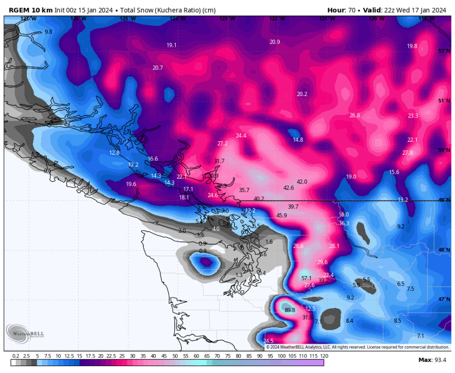
9 minutes ago, ShawniganLake said:
Big snow potential for BC, especially out the valley. Temps look a bit marginal near the coast.
I don't remember the last time I've seen this much snow modelled on the RGEM within 70hrs. Might not verify at that intensity bit still. Huge potential.
-
1
-
-
7 minutes ago, ShawniganLake said:
Crazy amounts of snow up here next week. Euro shows over 20” here from 2 separate storms.
Hopefully it verifies. Models seem to be coming into agreement so its a realistic possibility now but still far from a lock.
-
40 minutes ago, Phil said:
Odds against a cold Feb, however this week is a good example of how fluky timing in pattern forcings can lead to fluky regional weather patterns. Not impossible that could happen in Feb as well.
Fair enough. Do you think the PNW is done with the arctic air for January as well once the PV lobe shifts east?
-
11 minutes ago, MossMan said:
He will just say that if the SSW happens it will be east focused.
Well it may very well be east focused.
-
If I recall correctly, a while back you said that February is a write off for PNW cold. However, do you still think so or has your opinion changed since we are now expecting another SSW event?
-
7 minutes ago, Phil said:
+PNA and -NAO don’t really work well together, so I’d wager at least neutral/dormant PNA during next -NAO cycle (probably starts Feb 10-15).
Maybe another cold period in the PNW around that time then. One can hope. It can still get cold here in February. I remember February 2018 was quite cold and there was a region wide snowstorm up here in SWBC late month.
-
2
-


February 2024 Weather in the PNW
in West of the Rockies
Posted
It's still a long ways out but it will be quite remarkable if the PNW can win another cold blast with the upcoming SSW.
It used to be that SSW's mostly dropped the cold back east but it seems like in recent years that it's almost a given that the PNW gets at least some of the cold. Just wow.