The Snowman
-
Posts
422 -
Joined
-
Last visited
-
Days Won
1
Everything posted by The Snowman
-
2/1 - 2/3 MW/Lower Lakes Major Winter Storm (GHD-3)
The Snowman replied to Tom's topic in East of the Rockies
Will never forget the anti-snow stance Jerry Taft (RIP) would always take (though he would generally end up right more often than you might think!) -
2/1 - 2/3 MW/Lower Lakes Major Winter Storm (GHD-3)
The Snowman replied to Tom's topic in East of the Rockies
Place your bets, 12z ECMWF running. -
2/1 - 2/3 MW/Lower Lakes Major Winter Storm (GHD-3)
The Snowman replied to Tom's topic in East of the Rockies
Attaching a few excerpts of regional NWS AFDs I found interesting, as far as keys to trying to see past model mayhem. OMA: GID: TOP: -
2/1 - 2/3 MW/Lower Lakes Major Winter Storm (GHD-3)
The Snowman replied to Tom's topic in East of the Rockies
Personally I take more comfort in the fact that a significant storm is still being shown than a shift away from me locally; there's plenty of time for further shifts to occur, but the second we start seeing a weaker trend is something to *really* be concerned about. -
2/1 - 2/3 MW/Lower Lakes Major Winter Storm (GHD-3)
The Snowman replied to Tom's topic in East of the Rockies
Agreed, I can relate way too much to the despair but my gut says Iowa ends up in the action. Omaha ... not so sure. -
2/1 - 2/3 MW/Lower Lakes Major Winter Storm (GHD-3)
The Snowman replied to Tom's topic in East of the Rockies
Bummer run I say despite 6" in the forecast -
2/1 - 2/3 MW/Lower Lakes Major Winter Storm (GHD-3)
The Snowman replied to Tom's topic in East of the Rockies
A little faster & further south as it starts coming onshore California at Hour 102 -
2/1 - 2/3 MW/Lower Lakes Major Winter Storm (GHD-3)
The Snowman replied to Tom's topic in East of the Rockies
Energy that will eventually produce this storm looks further south off the SW coast of Cali at Hour 66 (compared to 18z) -
2/1 - 2/3 MW/Lower Lakes Major Winter Storm (GHD-3)
The Snowman replied to Tom's topic in East of the Rockies
Present & accounted for, for the 00z GFS Looking forward to my hopes shattering on this run -
2/1 - 2/3 MW/Lower Lakes Major Winter Storm (GHD-3)
The Snowman replied to Tom's topic in East of the Rockies
Living in fantasyland with the 12z GFS, bear with me here... At its peak, the model has almost 0.4" QPF falling in a six-hour timeframe with temperatures averaging around 15 degrees, which should result in snow ratios good enough for 10" of snow. Pretty wild. -
2/1 - 2/3 MW/Lower Lakes Major Winter Storm (GHD-3)
The Snowman replied to Tom's topic in East of the Rockies
Better than a southward shift I suppose... -
2/1 - 2/3 MW/Lower Lakes Major Winter Storm (GHD-3)
The Snowman replied to Tom's topic in East of the Rockies
GEFS precip shield actually looking somewhat south for Nebraska compared to 06z -
2/1 - 2/3 MW/Lower Lakes Major Winter Storm (GHD-3)
The Snowman replied to Tom's topic in East of the Rockies
Meanwhile, the 12z GFS is also coming in much colder for the evening of February 3rd in the wake of this system compared to the 06z; by 9pm, temps are at -23 in Omaha (-13 in the 06z run, and we ended up bottoming out at -32 degrees that evening) -
2/1 - 2/3 MW/Lower Lakes Major Winter Storm (GHD-3)
The Snowman replied to Tom's topic in East of the Rockies
Well, it looks like this will be the run that sets me up for disappointment when the inevitable shift south (or even continued hatred of snow from the Euro) comes back -
2/1 - 2/3 MW/Lower Lakes Major Winter Storm (GHD-3)
The Snowman replied to Tom's topic in East of the Rockies
Can't share graphics but a look at the 12z ECMWF ENS clusters shows: 50% of members with a low in western TN/KY at Hour 168 37% of members with absolutely no storm and an incredibly suffocating Canadian high pressure 11% of members with a low on the IA/MO/IL border nexus at Hour 168 I share concerns about the Arctic high ending up being too strong; it's happened at least once this winter where a Canadian HP's influence was underestimated by models and only became apparent as the event was happening. -
Things are ... ah ... not so great here in Omaha with these latest runs
-
That's fair, I agree - here in Omaha we'll have to rely on some type of NAM-like solution that shoots out a band of heavy snow west of the actual primary heavy-snow-zone to give us anything above 5", otherwise 2-5" (isolated 5" at least) seems valid.
-
Cheers to double digits! NWS Omaha has slashed the city's point & click total to less than 4", so I envy your upgrade!
-
NAM looks to give areas just north of Omaha a foot, waiting for the event to actually end so I can put up a graphic. But is it really realistic to have snow last that long amidst dry Canadian air after the main snow bands push through?
-
00z NAM reversing the recent trend of drying out the western portion of this snow shield, looking like it will boost totals for Omaha. Also a very pleasant surprise seeing our eastern Iowa friends with juicier totals this run!
-
Fascinating band of moderate to heavy snow shown by the NAM on the northeast NE/southeast SD border between hours 45-51. Edit: A band which lays down somewhere close to a foot of snow, at that!
-
Do I see an eastern shift on the 00z NAM here?
-
Oh I'm not here to advocate one side or the other, that's just my takeaway. The beauty of an open forum like this is that no one is forced to agree with another.
-
FWIW, can't post the graphics but cluster analysis of the ECMWF ENS has 45% of members in line with what Grizz posted just above, 41% of members shifting the core of the snow about 20 miles west, and the last 13% having a further east trajectory not too dissimilar from the 18z GFS (with a sharper western cutoff however). Not sure if it's useful, but there ya go
-
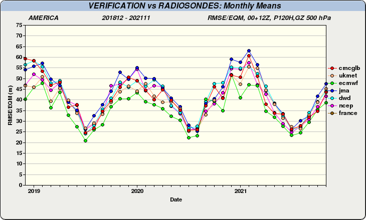
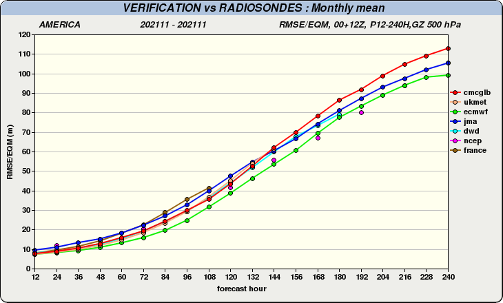
From a statistical view, the ICON (turquoise line, a.k.a. DWD) is more or less on par with the UKMET over the last few years, and not in a good way - indeed, for the month of November, the order of models from most- to least-accurate at the 120-hour timeframe was: ECMWF GFS CMC ICON UKMET JMA On a side note, the GFS was more accurate than the ECMWF beyond hour 144.