The Snowman
-
Posts
422 -
Joined
-
Last visited
-
Days Won
1
Everything posted by The Snowman
-
January 11-13 Major Winter Storm/Blizzard
The Snowman replied to Hoosier's topic in East of the Rockies
Radar returns re-intensifying as they rotate down through eastern Nebraska; snowing essentially sideways at this point, really pretty to watch -
January 11-13 Major Winter Storm/Blizzard
The Snowman replied to Hoosier's topic in East of the Rockies
Absolutely no clue how much we've gotten just west of downtown, lol. Some spots with not even a flake accumulated due to wind, some spots with >2 foot drifts. -
January 11-13 Major Winter Storm/Blizzard
The Snowman replied to Hoosier's topic in East of the Rockies
don't like the radar look for Omaha -
January 11-13 Major Winter Storm/Blizzard
The Snowman replied to Hoosier's topic in East of the Rockies
Well I guess if you're gonna commit to one model, you better commit to the bitter end lol -
January 11-13 Major Winter Storm/Blizzard
The Snowman replied to Hoosier's topic in East of the Rockies
18z GFS continuing a lovely recent trend of strengthening QPF field in Nebraska and Iowa -
January 11-13 Major Winter Storm/Blizzard
The Snowman replied to Hoosier's topic in East of the Rockies
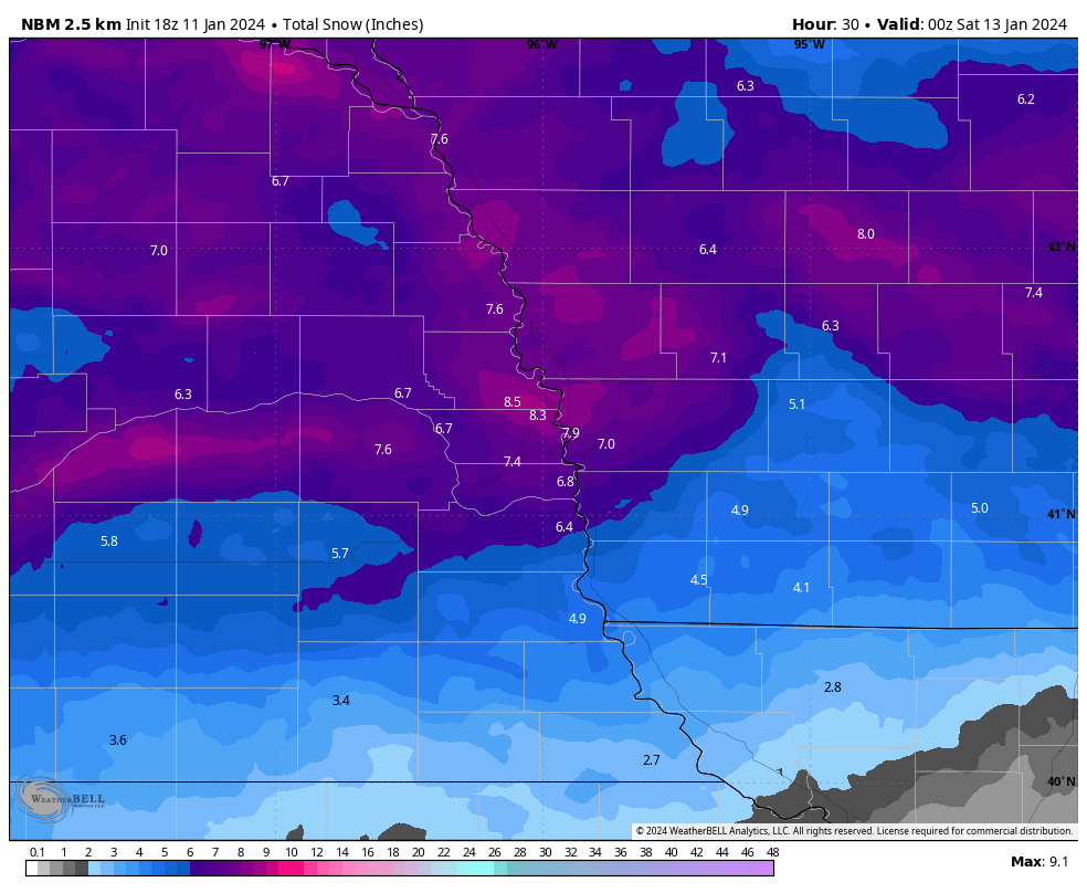
Also strange: if OAX (and most all models, for that matter) are correct in ratios landing somewhere between 15:1 and 18:1, why is NBM going with 8.8" of snow just north of Omaha from 0.71" QPF (ratio of just above 12:1)?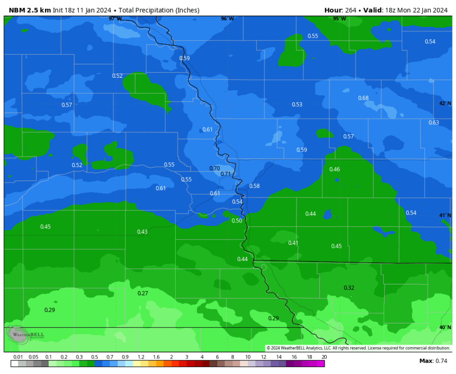

-
January 11-13 Major Winter Storm/Blizzard
The Snowman replied to Hoosier's topic in East of the Rockies
This makes little sense to me - essentially taking 10:1 maps and calling it a day. NWS Omaha expecting much higher ratios though, with their fresh AFD: -
January 11-13 Major Winter Storm/Blizzard
The Snowman replied to Hoosier's topic in East of the Rockies
Once again gnarly stuff from the Euro.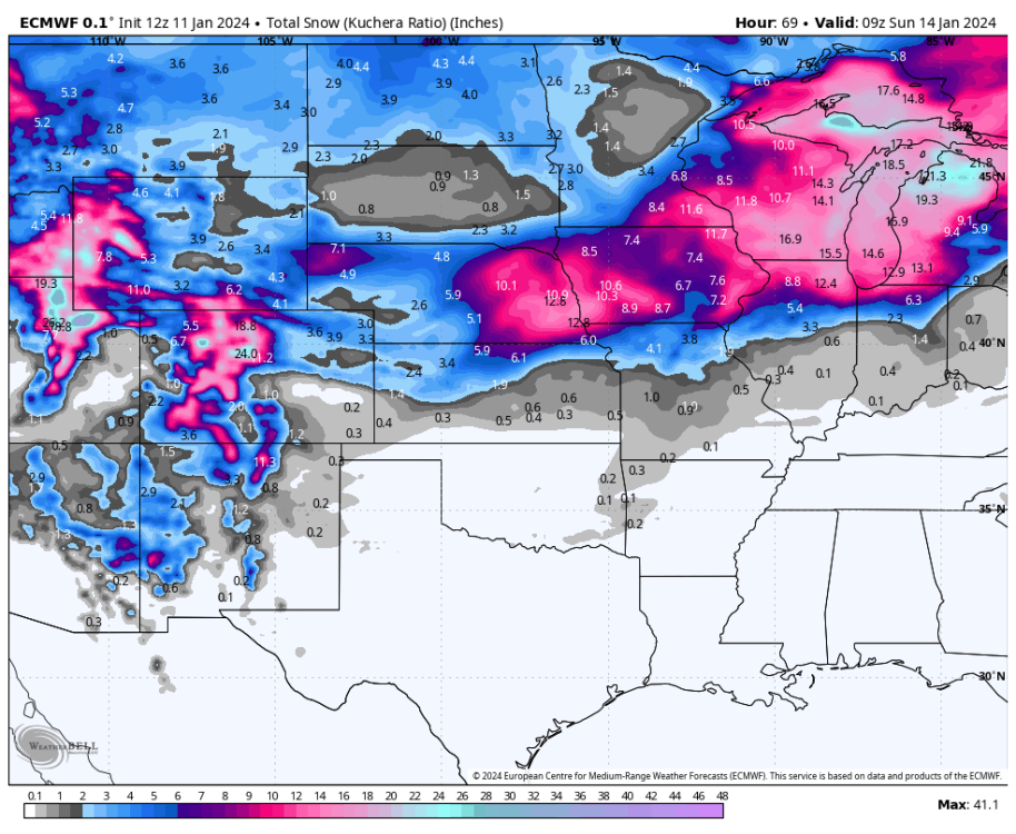
-
January 11-13 Major Winter Storm/Blizzard
The Snowman replied to Hoosier's topic in East of the Rockies
12z models coming in really awesome for Omaha, taking most of them verbatim it would be an easy 6-8" for the metro, and then of course the higher-end hi-res models breach 12". Can't wait to see OAX's update. -
January 11-13 Major Winter Storm/Blizzard
The Snowman replied to Hoosier's topic in East of the Rockies
Alright, so Omaha's outlook now sits as... 00z NAM (Kuchera): 12.0" 00z NAM (10:1): 7.4" 00z NAM 3km (Kuchera): 4.7" 00z NAM 3km (10:1): 2.8" 00z RGEM (Kuchera): 11.2" 00z RGEM (10:1): 6.7" 00z ICON (10:1): 6.9" 00z GFS (Kuchera): 6.8" 00z GFS (10:1): 3.4" 00z GEM (Kuchera): 12.5" 00z GEM (10:1): 6.8" ... Post-00z NBM: 4.5" ... Flowers: 5.5" Strange to me, even accounting for any snow crystal degradation due to wind, that forecasts would come in so firmly below the Kuchera average of 9.4", and even the 10:1 ratio average of 5.7". Edit: The above also implies local SLR of 16:1. -
January 11-13 Major Winter Storm/Blizzard
The Snowman replied to Hoosier's topic in East of the Rockies
Ride or die -
January 11-13 Major Winter Storm/Blizzard
The Snowman replied to Hoosier's topic in East of the Rockies
I guess it’s go-time from a models perspective… if the 0z suite keeps improving Nebraska totals, imagine OAX will follow suit in the overnight update… high stakes! Here we go! -
January 11-13 Major Winter Storm/Blizzard
The Snowman replied to Hoosier's topic in East of the Rockies
Nice increase in QPF for Nebraska after a worrying 12z run. -
January 11-13 Major Winter Storm/Blizzard
The Snowman replied to Hoosier's topic in East of the Rockies
Nice tidbit from Omaha AFD on why the NBM is too low: -
January 11-13 Major Winter Storm/Blizzard
The Snowman replied to Hoosier's topic in East of the Rockies
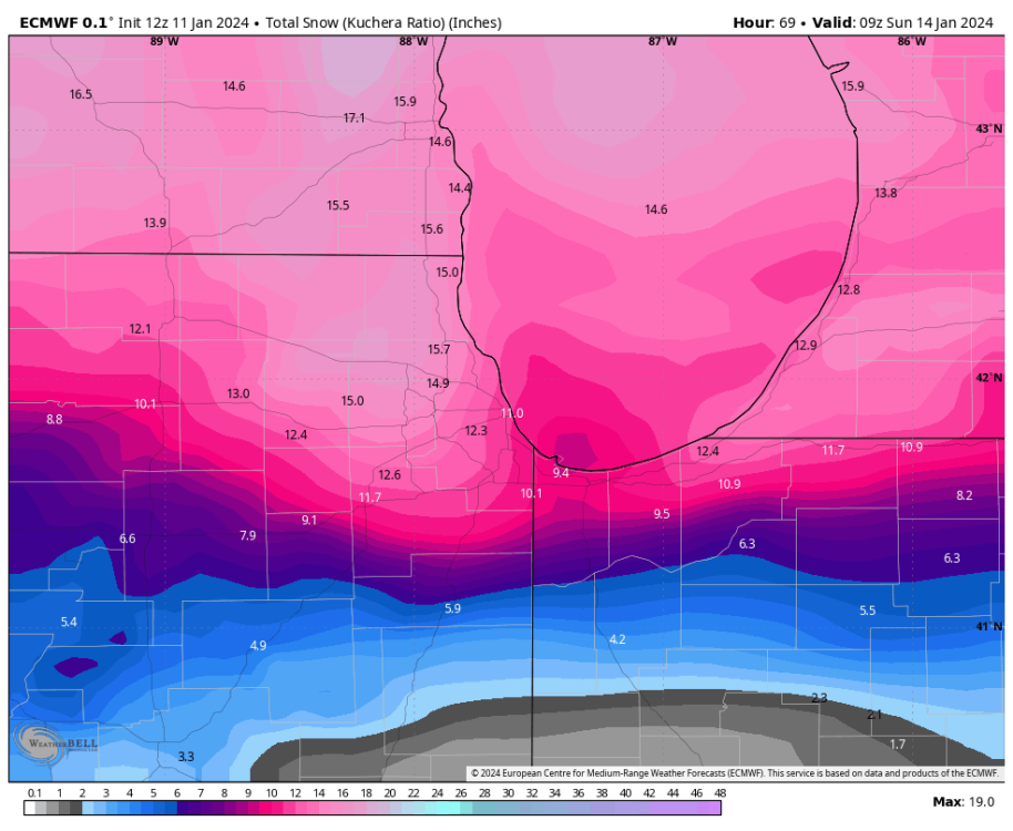
Chicago absolutely buried on that Euro run (subtract ~4" from Cook/Lake/McHenry nexus area to account for today's event)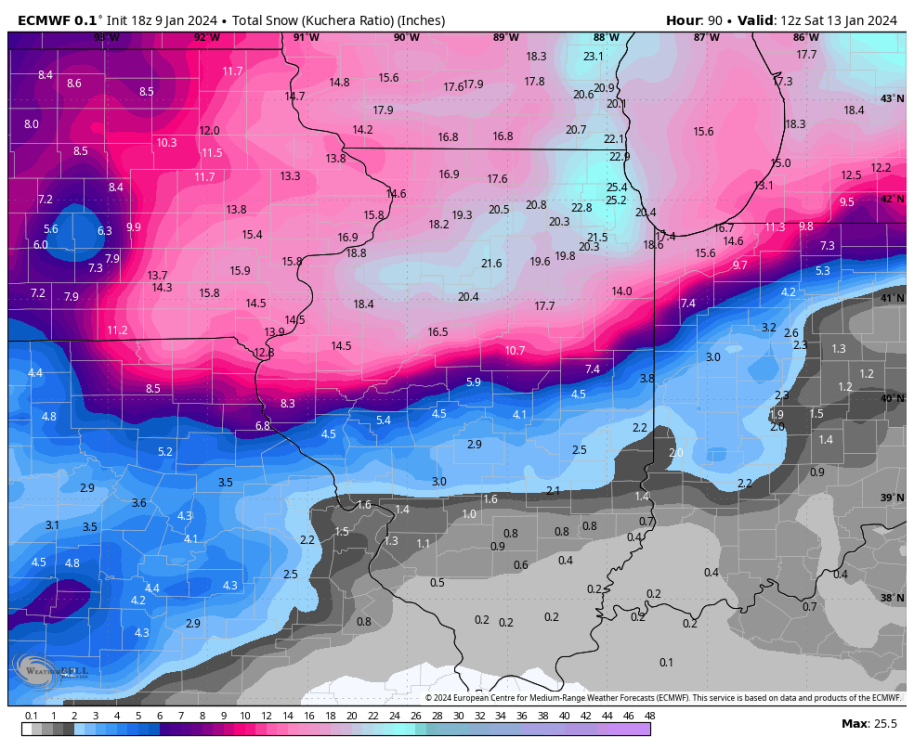
-
January 11-13 Major Winter Storm/Blizzard
The Snowman replied to Hoosier's topic in East of the Rockies
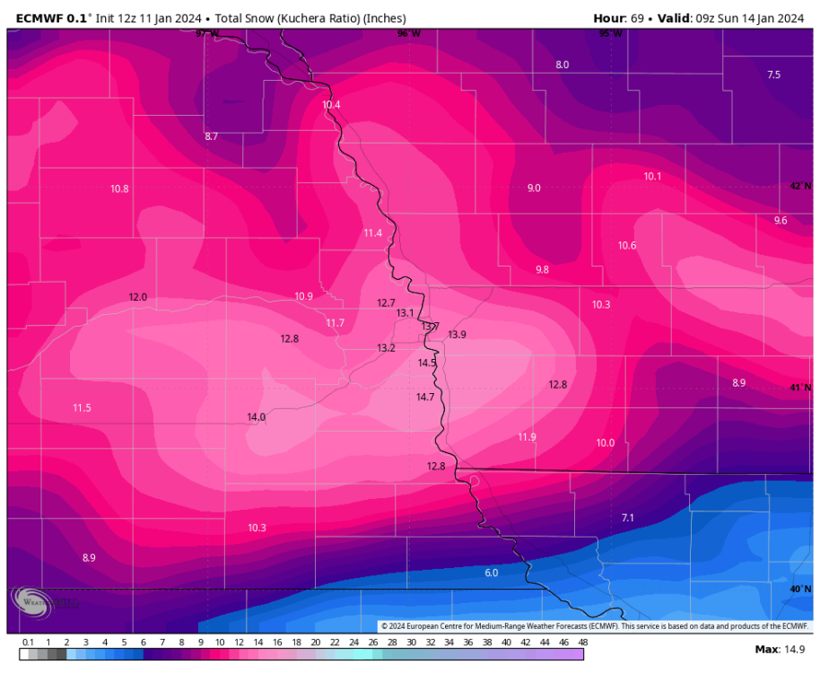
Gnarly Kuchera numbers from the 18z Euro... one can dream of almost a foot of fluff!
-
January 11-13 Major Winter Storm/Blizzard
The Snowman replied to Hoosier's topic in East of the Rockies
EPS control member laying down between 4-5" of 10:1 ratio snows from this system in Omaha; assuming the ~18:1 ratios that most models seem to be targeting, this would likely exceed half a foot. Neat stuff.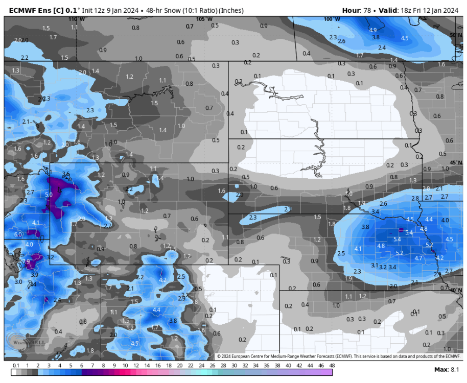
-
Blizzard conditions here just west of downtown Omaha. Wind absolutely screaming
-
Radar filling in over eastern Nebraska as the system starts trekking east and continuing to mature... will be at least a nice consolation prize to see some solid flakes & rates in the streetlights tonight.
-
Absolutely massive flakes, nickel size approaching quarter size
-
Omaha situation certainly looking a little dire early on here but note that NWS Omaha updated the WSWarning around 11:15 AM and left forecast totals unchanged; one would think if they saw serious issues there would have been at least a minor shift. Also, as the storm system begins to really ramp up, already seeing strengthening returns in far SE Nebraska moving northwards ... think early melting might dent totals, sure, but several inches still a very realistic outcome.
-
Big flakes flying here in Omaha, NWS upped forecast to 7-11" (over 8" point & click) ... here we go!
-
00z HRRR appears to be trying to tick north a tad; pushing heavier forecasted snows into Omaha it would seem
-
Post-18z NBM suite bumps up Omaha totals by another 1-2" or so
-
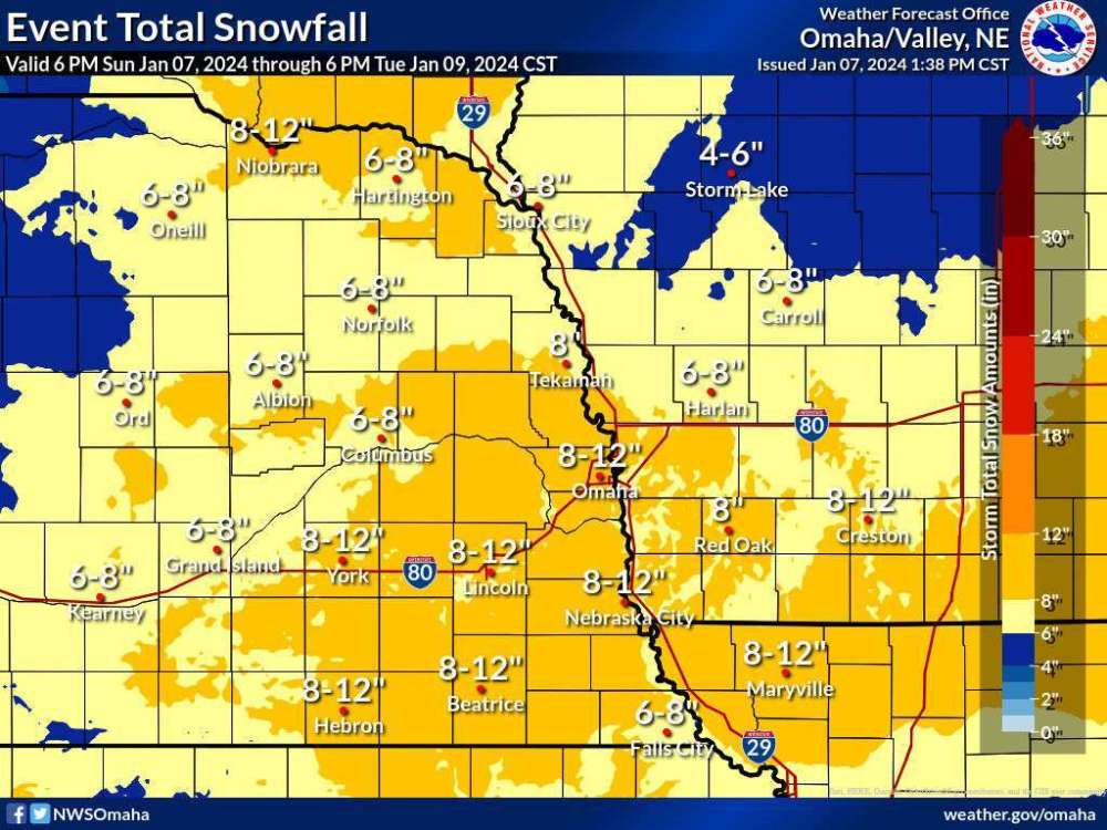
NWS Omaha as of an hour ago; really increased city totals