

jaster220
-
Posts
12213 -
Joined
-
Last visited
-
Days Won
59
Everything posted by jaster220
-

November 2023 Observations and Discussion
jaster220 replied to westMJim's topic in East of the Rockies
@tStacsh GEM hinting at a little action this coming Sunday night wrt LES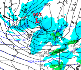
-
11/19 - 11/22 Arklatex Low - Great Lakes/OHV Cutter???
jaster220 replied to Tom's topic in East of the Rockies
DTW hourly calling for 0.82" and blustery conditions late morning/midday: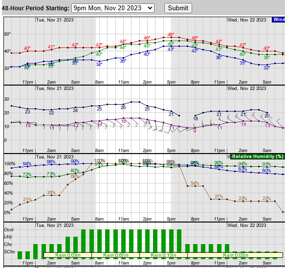
-
11/19 - 11/22 Arklatex Low - Great Lakes/OHV Cutter???
jaster220 replied to Tom's topic in East of the Rockies
How often do you see returns over KOMA and KTOL from the same storm whose SLP is several states away? Returns trying to show SN over parts of WMI. Kind of surprising how close this is to a winter event considering there was no adverting it as such and no dump of arctic air beforehand.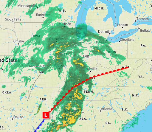
-
11/19 - 11/22 Arklatex Low - Great Lakes/OHV Cutter???
jaster220 replied to Tom's topic in East of the Rockies
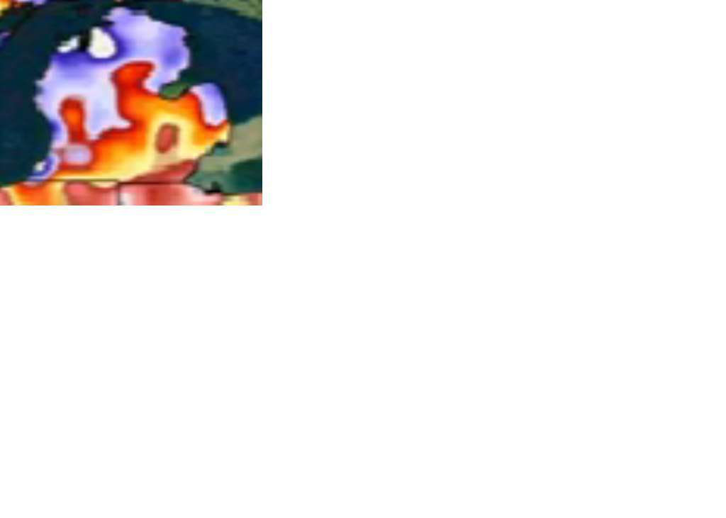
Currently, the freezing line is not more than a county or two ENE of here across S ONT. Even some stations reporting 32F in SEMI. Makes me think that there is more potential for mixy p-type than the offices have been willing to accept. Just then I noticed the NCEP map and sure enough, they have the mixed p-type line just about splitting Detroit. Stubborn cold HP in ONT.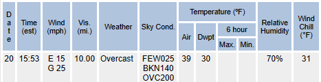
-
11/19 - 11/22 Arklatex Low - Great Lakes/OHV Cutter???
jaster220 replied to Tom's topic in East of the Rockies
Lotta moisture with this. A nice SLP presentation. DTX mentioning that this will come right over top of us, while elsewhere in their pm write-up (multiple contributors ofc) they mention it staying just to our south basically going across Erie into Lk Ontario. Hoping to see qpf on the higher end of forecast for a change. Not to mention we could use the moisture. -
11/19 - 11/22 Arklatex Low - Great Lakes/OHV Cutter???
jaster220 replied to Tom's topic in East of the Rockies
I liked this from the TAF for DTW: -
11/19 - 11/22 Arklatex Low - Great Lakes/OHV Cutter???
jaster220 replied to Tom's topic in East of the Rockies
Unless we spike towards midnight, this will be the coldest day at DTW since the 1st. Currently 39F/31F WC Temps are currently in the 20s just north of Toronto. Seems that region will be our cold source for future version(s) of this set-up. -
11/19 - 11/22 Arklatex Low - Great Lakes/OHV Cutter???
jaster220 replied to Tom's topic in East of the Rockies
Yeah, this system coming into legit cold would be impressive. Let's hope that comes to fruition as they are showing. -
11/19 - 11/22 Arklatex Low - Great Lakes/OHV Cutter???
jaster220 replied to Tom's topic in East of the Rockies
I know I mentioned having cold air to work with in future cycles. But tbh, in keeping with last winter's theme the S Stream systems never had true fresh arctic air to work with. The 12/23-24 storm came into warm conditions with a rain->snow scenario with the bitter air after the fact. Both other storms were very marginal temps as I suspect this one would be, even 4 or 6 weeks from now. Nino's are known to bring us a lot of split flow and here we see it again. -
11/19 - 11/22 Arklatex Low - Great Lakes/OHV Cutter???
jaster220 replied to Tom's topic in East of the Rockies
I was out on an errand and the winds have increased gusting near 30 mph. Many leaves blowing around. With WC's in the mid-30s and now overcast grey skies, its easy to see what this would look like in a future cycle.
-
11/19 - 11/22 Arklatex Low - Great Lakes/OHV Cutter???
jaster220 replied to Tom's topic in East of the Rockies
@Hoosier It looks like that slight bump in the jet will treat Chicago/your area much better than originally expected: This would be a nice system in mid-winter form. Iirc, last winter the S Stream systems just brushed your area and focused more favorably for DTW than ORD. The one on 1/25 for example: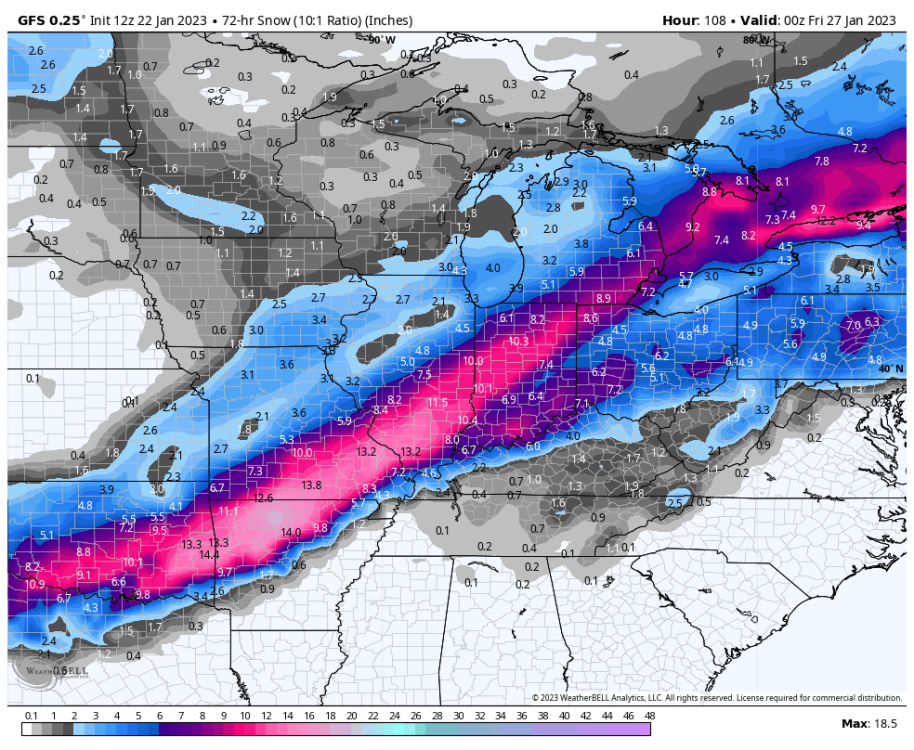
-
November 2023 Observations and Discussion
jaster220 replied to westMJim's topic in East of the Rockies
Clouds have pushed into lower MI a bit earlier than forecasted keeping temps from taking off like they did under sunny skies yesterday morning. Outside the UHI effects, mostly have 30s with the winds at some airports already frisky. A rather brisk day before the storm in progress.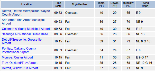
-
11/19 - 11/22 Arklatex Low - Great Lakes/OHV Cutter???
jaster220 replied to Tom's topic in East of the Rockies
I would agree that it is better than a continued warming into super/mega Nino threshold. But, sometimes there is an atmospheric lag-time though. So, while ENSO may have cooled, the effects aren't too quick to effect on our real wx. Anyways, looks like your wish for nice travel conditions has happened for ya. Later this winter, when the next HECS is imminent, you can play Jim Cantore in downtown Chicago for GHD-1, except you'll be in Central Park no doubt. -
Oh, it certainly could be, and tbh what you'd get up there vs here in a typical Nino could be vastly different. For Detroit, last winter acted a lot more like a Nino due to all the warmth. Was hoping maybe this winter would act more like the Nina we were supposed to get last winter. And it may, but nothing says it has to act like 07-08 here. Could just as easily act like 11-12 which was pretty much horrible across the board. I do feel strongly that there is a very low probability that we will see a repeat of the super snowy winter that MSP had:
-
11/19 - 11/22 Arklatex Low - Great Lakes/OHV Cutter???
jaster220 replied to Tom's topic in East of the Rockies
Time will tell, but I do like (for future storms) how it manages to keep the SLP south of here. Not that running up over DTX in November would be rare but it keeps the theme going from last winter in that regard. -
LOL. Thx, you made my day. Tbh, a lot of great winters had very blah Novembers especially outside the LES belts. I realize we pull on different ends of the rope since LES outbreaks rarely even impact Detroit. You're looking for arctic plunges and I'm looking for synoptic events like the one on tap for tomorrow. The rare Nov snowstorm in Detroit has almost always been bad juju so I am not upset this will be a rainer here.
-
Seems our gales of November are on the other side of the globe Cargo Ship Splits In Half During Storm In Turkey - Videos from The Weather Channel
-
Actually, strong Nino's tend to have winter up til Christmas, then it vanishes for a couple months during the heart of winter. The record breaking storm in Nov 2015 is a classic example.
-
November 2023 Observations and Discussion
jaster220 replied to westMJim's topic in East of the Rockies
These cold pools just east/NE in ONT have been a recurring theme. After a slight over-achievement in the high temperature department, the mercury dropped like a rock after sunset. Was already readings in the 20s inside the UHI of the burbs an hour ago. -
November 2023 Observations and Discussion
jaster220 replied to westMJim's topic in East of the Rockies
One year ago this evening visiblity was bliz-level at DTW: It ripped hard and dropped about an inch in 30 minutes or maybe less. It was a brief wall of white as a LES streamer from the ongoing storm in WMI held together like a fire hose all the way across the state. Nothing remotely close going on so far this November.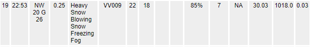
-
11/19 - 11/22 Arklatex Low - Great Lakes/OHV Cutter???
jaster220 replied to Tom's topic in East of the Rockies
Great call in noticing that jet streak movement. DTX: -
November 2023 Observations and Discussion
jaster220 replied to westMJim's topic in East of the Rockies
Yep. Really not seeing any true arctic intrusion into the CONUS besides a very brief period (1 day?) and it only comes far enough south to cover MI/WI really. In a way, I think this may bode well for the winter. Besides the Halloween blast, we are not getting the cold autumn that strong Nino's are known for around here. Typically, resident air masses that can support snow fall don't happen for SEMI until closer to Christmas, so we're about a month away at least around here. -
11/19 - 11/22 Arklatex Low - Great Lakes/OHV Cutter???
jaster220 replied to Tom's topic in East of the Rockies
This morning's 12z GFS and Euro take the SLP up to S Lk Huron. Meanwhile the R/GEM x-fer from WOH over to the EC. This is what I'm watching. IF the more northerly progression wins out, NMI could see a mix and/or coating perhaps before the moisture pulls eastward.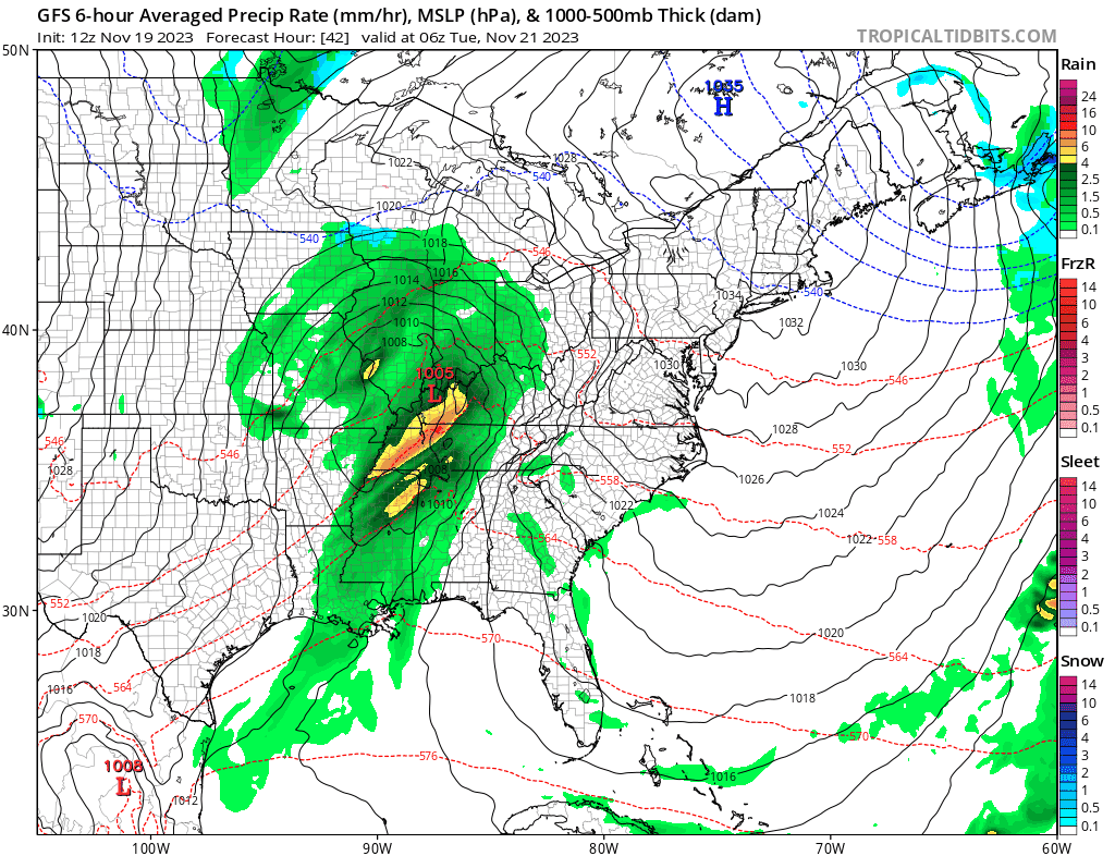
-
11/19 - 11/22 Arklatex Low - Great Lakes/OHV Cutter???
jaster220 replied to Tom's topic in East of the Rockies
Meant to show that was my very own DTX's overnight AFD. I am interested in exactly where the models come into agreement on the SLP track. That ofc is always a make-or-break deal here in the Metro. Is this system a re-visit of this back in June which delivered 0.64" qpf at DTW on a NNE wind? Either way, this will mark the 2nd legit storm this month for SEMI.
-
11/19 - 11/22 Arklatex Low - Great Lakes/OHV Cutter???
jaster220 replied to Tom's topic in East of the Rockies
@Tom Text book STJ system. Maybe in mid-winter we could see some cold air in place along and north of the track. as a second low pressure develops and moves in from the Ark- La-Tex. This will strengthen the pressure gradient over the Great Lakes tomorrow, with the low pressure system moving into the Ohio River Valley on Tuesday. Unsettled weather and breezy conditions are expected as the low approaches the Ohio River Valley and southern Great Lakes.


