


jaster220
-
Posts
12212 -
Joined
-
Last visited
-
Days Won
59
Posts posted by jaster220
-
-
10 hours ago, Iceresistance said:
GFS went for 979 mb in OK
Not sure which run you meant, but I'd take the 12z in a heartbeat.

-
11 hours ago, Tom said:
Late start this morning, but back in the saddle...the data continues to support a southern track...0z EPS indicating an Arklatex Low that cuts NE into the Lower Lakes....for an ensemble showing a mean SLP in the 980's and deepening suggests to me this has Bomb potential. The Operational runs will have varying run-to-run inconsistency with strength/phasing, etc but the overall "picture" is there that a bonafide Winter Storm is in the cards.
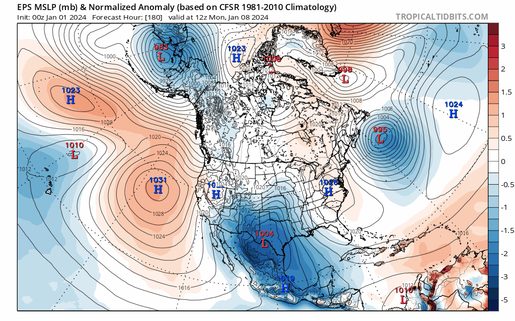
Verbatim how could that be anything but a dynamic storm here in NMI. Seems like it maxes out at this LAT as well. Notably, I do not see any arctic HP feeding cold as you've mentioned before, so without looking into thermals I'm presuming this would be much like our March storm that produced it's own cold via dynamics of lift. Fairly progressive as well, so not huge totals via duration but like in March, a quick-hitting medium totals style system.
Sure would be a nice "welcome present" at my new abode tho!

On a side note, they are making snow furiously at the slopes just south of here:
-
Snow fell here at the new place a couple of times today. Just enough to coat the ground with a couple or few tenths. This evening after dark it got a bit windier and temps were in the 20's so even the roads were getting coated. It looked and felt legit winter a couple times this evening.
-
 2
2
-
-
14 hours ago, Stacsh said:
This will be fun to watch and fall apart. Either way, Looks like a week of winter coming second week of January when it should be winter so that’s cool. Probably will have to rely on LES snow once again.
only 10 days out what could go wrong?
12 hours ago, westMJim said:Where have I seen that before????
Whatever happens, you can be pretty sure the models are over-inflating amounts at this range as seen with every storm the last few years.
-
Lotta worms out there this evening
-
 2
2
-
 1
1
-
-
9 minutes ago, Minny_Weather said:
Say it with me... BARNEY RAMPAGE!!!
This is the EPS control in clown range so it means nothing at all, but god D**n it's been so long since I've seen a map like this lol

What, 5 years prolly. Jan of '19 be my guess.
-
2 hours ago, chescowxman said:Some snow drought factoids that you might find of interest. We have talked about this before but here in Chester County PA if we can just get through January 3rd without recording a full one inch daily snowfall we will set a new record for longest period between such events - our last greater than 1" snow event was on March 12, 2022 when we recorded 4.3" of snow. The current non 1" record is the only winter in Chester County since 1888 that recorded absolutely no snow at all. So nothing measurable (more than a trace) - this was during the non-winter of 1972-73. During that stretch we went from February 24, 1972 until December 16, 1973 or 661 days without a daily observed snowfall of at least 1 inch.To help hopefully put some of this in context for all of you snow lovers out there....be very thankful you were not around to remember back when we really had true snow droughts. Are you surprised to find out that from the mid-1930's through the late 1950's. Here in Chester County we had not even one above average snow season?? (Current 30 year average 35.9") So for 23 straight winter seasons from the winter of 1934-35 season through the 1956-57 season not one winter season featured above normal snowfall - snow enthusiasts must have been miserable!!By contrast folks today with more recent memories of here in Chester County PA may potentially be surprised to hear that the last 2 complete decades (2000's/2010's) featured two of the top four snowiest decades in our history going back through the 1890's. With my view of typical cyclical weather patterns....it would make one think we are way overdue for some non-snowy winters before the next snowy period sets in. Thoughts??
Those crappy decades seem widespread and also were lame here in SMI. Makes you wonder if its part of a longer cycle that we will never have to see again? Perhaps there was a period in the distant past when most of 2-1/2 decades had winters AN and this was nature's balance for that? We just don't really know. I'm sure there are shorter cycles buried within longer ones, but our data set is so short we'd have a hard time figuring out a 100 year event, let alone a once in 250 or 500 year event.
-
2
-
-
11 hours ago, westMJim said:
Some weather history for December 26 in southern Lower Michigan
1985: Muskegon sets a daily snowfall record of 14.4 inches during a long stretch of snowy weather. The monthly total for December is 57 inches.
2001: A foot of lake effect snow piles up at Grand Rapids as a week-long snow blitz drops about 4 feet of snow at Grand Rapids.
2016, Detroit, Flint, and Saginaw set record highs of 57, 56, and 54 respectively.
2012, a large Gulf low lifted northeast along the Appalachian Mountains and clipped southeast Michigan bringing a widespread accumulating snowfall to the area. By the following morning, 4″ to 7″ had accumulated across the southeast half of the area, with higher amounts of 14″ in Lakeport and 11.1″ in Port Huron. Detroit and Flint measured storm total accumulations of 6.2″ and 5″ respectively. Further northwest, Saginaw received a glancing blow and measured only 1.5″.
1914, the overnight temperature plummeted to -12 degrees in Saginaw, which is 30 degrees below the average overnight temperature!
Our good buddy @Tom wrote that one.

-
 1
1
-
-
2 hours ago, Clinton said:
Ensembles of the GFS and CMC seem to target NE Missouri with the highest totals.


Looking better your way. Hopeful for you to score!
-
1
-
-
Meanwhile, to the east side of the massive system. This has been the worst stretch of this I can remember tbh

Since that very brief visit by winter a week ago, the last 6 days here in DTW-land have been very grey, and damp, when not actually raining with highs and lows stuck in a blah range.
-
 3
3
-
-
6 minutes ago, Tom said:
Well, this Beast definitely laid down some white gold over the central Plains...
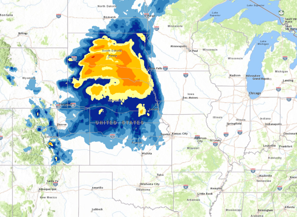
Would more than cover both peninsula's of Michigan. Large storm for sure!
-
3
-
-
Merry Christmas everyone!!! I hope your day is bright and full of good cheer!

-
4
-
 4
4
-
-
34 minutes ago, CentralNebWeather said:
12z FV3. By the way, my family is still sleeping. Nice to have a 23 and 18 year old who would rather sleep in.


You're the real kid on Christmas morning, eh??
-
1
-
-
This was the LES belts of The Mitt a year ago, but SD sure knows how to do Big Dogs.
Blizzard Warning
URGENT - WINTER WEATHER MESSAGE
National Weather Service Rapid City SD
356 PM MST Sun Dec 24 2023

SDZ046-047-049-251400-
/O.CAN.KUNR.WW.Y.0029.000000T0000Z-231225T0000Z/
/O.CON.KUNR.BZ.W.0003.231225T1800Z-231227T0600Z/
Mellette-Todd-Tripp-
Including White River, Norris, Cedar Butte, Mission, Rosebud,
Saint Francis, Parmelee, Winner, and Ideal
456 PM CST Sun Dec 24 2023

...BLIZZARD WARNING REMAINS IN EFFECT FROM NOON MONDAY TO
MIDNIGHT CST TUESDAY NIGHT...
...WINTER WEATHER ADVISORY FOR THIS AFTERNOON IS CANCELLED...

* WHAT...Blizzard conditions expected. Total snow accumulations of
  10 to 22 inches. Winds gusting as high as 55 mph.

* WHERE...Mellette County, Todd County and Tripp County. This
  includes the Tribal Lands of the Rosebud Reservation.

* WHEN...From noon Monday to midnight CST Tuesday night.

* IMPACTS...Travel could be very difficult to impossible.
  Widespread blowing snow could significantly reduce visibility.
  Gusty winds could bring down tree branches.

PRECAUTIONARY/PREPAREDNESS ACTIONS...

A Blizzard Warning means the combination of snow, blowing snow,
and strong winds will create dangerous whiteout conditions.

Road conditions are available on your smartphone from the
5 1 1 app for your state.
-
3
-
-
28 minutes ago, CentralNebWeather said:
Good run for Fremont on 0z HRRR
Good Luck and Merry Christmas to y'all out there in The Plains. Enjoy nature's great Christmas gift!
-
3
-
-
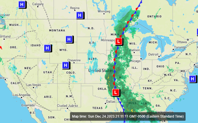
This so reminds me of the due S to N stream of moisture that fed the Halloween 1991 MN Bliz! I remember seeing radar shots on news channel looking like this and the coma head right over MSP.
-
3
-
-
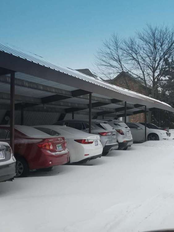
A year ago today, my 2" of fresh snow was whipped into nice little drifts that made it look (in places at least) like a much bigger storm.
-
4
-
-
-
-
3 hours ago, westMJim said:
In looking at the records for Dec 2019 all of lower Michigan was warmer than average that month. It could be that the map is of November of 2019 that was colder than average in lower Michigan.
I did think perhaps the map was not correct. Thx for confirming it
-
1
-
-
44 minutes ago, Anti Marine Layer said:
Long range of dates for the storm to pass through
It's a creeping Low. As @Andie said, some Peeps spend Christmas in Cut-offs (SLPs).
-
1
-
-
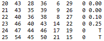
23 minutes ago, Clinton said:
Ya I think it's been warm this December and here is a look at the last 18 Decembers.


Strange. Mby records of Dec 2019 show very few cold days in Marshall with (3) notably hot days. You would not get that impression looking at their map for that year. Not like Marshall is in some micro-climate either.
-
3
-
-
15 hours ago, Niko said:
This December might actually end up being a snowless month for my area and along w that, way AN temps. Nino doing its thing I guess.
Monday spared me that fate. Had a little here in Canton, and from Brighton up towards Flint there was easy 2-3"
-
1
-
-
Been snow OTG all week, and now this.
Certainly not deep, but a lot more like winter than elsewhere.
-
2
-
 1
1
-
2
-


January 2024 Observations and Discussion
in East of the Rockies
Posted
Not sure how THIS is lackluster??